Census 2020
Census 2020 is the most recent decennial census, which generates population counts by age, sex, race/ethnicity, for people living in households and group quarters, as well as counts of housing units, both occupied and vacant.
The decennial (every 10 years) U.S. Census aims to count every resident in the United States. It is mandated by Article I, Section 2 of the U.S. Constitution and has been taking place since 1790. The data collected by the decennial census determine the number of seats each state has in the U.S. House of Representatives and is also used to direct the distribution of federal funds. The results of each decennial census are also used by states for redistricting. Redistricting is when state officials realign congressional and state legislative districts, taking into account population shifts since the last census and assuring equal representation for their constituents.
Users should note that the 2000 decennial census was the last recent census that contained both a short form (given to all of the population) and a long form (given to just a sample, or portion, of the population). Historically, the long form generated the data regarding detailed social, economic and housing characteristics. However, these data are now collected by the ongoing American Community Survey and were not asked in the 2010 or 2020 decennial censuses. Learn more about the American Community Survey (ACS). Click here to download a copy of the questionnaire.
We've catalogued some of the most popular datasets from the 2020 decennial census in the tabs below. Additional tools for locating data 2020 decennial data follow.

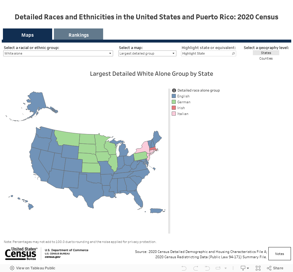
2020 Census Detailed Demographic and Housing Characteristics File A
The 2020 Census Detailed Demographic and Housing Characteristics File A (Detailed DHC-A) includes detailed data tables on population counts and sex-by-age statistics for approximately 1,500 detailed racial and ethnic groups, such as German, Lebanese, Jamaican, Chinese, Native Hawaiian, and Mexican, as well as American Indian and Alaska Native (AIAN) tribes and villages like the Navajo Nation.

How Has Our Population Changed?
See how the total population and race and ethnicity groups have changed over time for the nation, states, metropolitan areas, micropolitan areas, and counties based on the 2000, 2010, and 2020 Censuses,
")
Census 2020 Map Tool (block level)
A web-based application for Minnesota blocks, populated with data from the 2020 Census Redistricting Data publication (PL 94-171).

Redistricting data files for common Minnesota geographies
A series of CSV files prepared by the Minnesota State Demographic Center for commonly used Minnesota geographies. When possible, files contain 2010 and 2020 variables in a single file.

2020 Census Demographic Map Viewer
The Census Bureau’s 2020 Census Demographic Data Map Viewer is a web map application that includes state-, county-, and census tract-level data from the 2020 Census. The map includes data related to population, race, Hispanic origin, housing, and group quarters.

2020 Population and Housing State Data
The Census Bureau’s interactive data tool that displays population and housing unit changes for states, Metropolitan Statistical Areas (MSAs), Micropolitan Statistical Areas, and counties. Data are from the 2010 and 2020 censuses.

Racial and Ethnic Diversity in the United States
The Census Bureau’s interactive data tool that measures racial and ethnic diversity at the state- and county- levels. Data are from the 2010 and 2020 censuses.

data.census.gov
The Census Bureau's data retrieval tool replaces the old American FactFinder. The table display feature allows the user to dynamically add geographies, topics, or any applicable filters.

Quick Facts
The Census Bureau’s QuickFacts provides statistics for all states and counties, and for cities and towns with a population of 5,000 or more, including 2020 census statistics
")
National Historic Geographic Information System (NHGIS)
NHGIS, a project of the University of Minnesota Population Center, provides free aggregate census data and GIS-compatible boundary files for volumes of decennial data back to 1790 as well as the more recent American Community Survey data. Users create a free account to extract data. Statistical software not required; Microsoft Excel will suffice.
")
Integrated Public Use Microdata Series (IPUMS-USA)
IPUMS-USA, a project of the University of Minnesota Population Center, provides free, anonymized individual record census data (microdata) samples for volumes of decennial data back to 1850 as well as the more recent American Community Survey data. The data may be tabulated by advanced users for geographies down to the Public Use Microdata Area (PUMA) level, which contain at least 100,000 people. Users have to create a free account to tabulate data online or extract data. Statistical software required for extracts.

Minnesota Compass
Minnesota Compass, a project of Wilder Research, features thousands of interactive graphs, maps, and tables for MN geographies. Its Demographics Topic section is rich with decennial data on total population, race and ethnicity, and age data, often dating back to the 1950 or 1960 decennial census. By using the dropdown menus in the gray banner above any graph, users can change geographies, further disaggregate data by subgroups, view data tables, or download data in a CSV file. Geographic profiles contain popular 2000 decennial data points compared more recent data.