
 Home
Home  Membership
  Customer Support
  Create
  Blog
Blog 
FREE Blank World Map
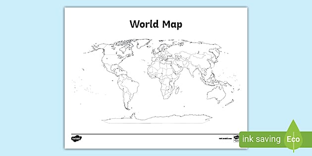
How do I use this Printable World Map for kids?
Our Printable World Map for kids has been designed to help you teach your students about world geography. It can be used to teach children about the different continents, countries, and oceans that make up our planet.
Related Searches
 map of the world
world map with countries
map of world
blank world map
world map with countries labeled
world map template
europe map
geography
continents of the world
map of the world template
map
world map worksheet
map of the world with countries
world map with countries labelled
map templates
map and globe skills
continents
maps
map of the world
world map with countries
map of world
blank world map
world map with countries labeled
world map template
europe map
geography
continents of the world
map of the world template
map
world map worksheet
map of the world with countries
world map with countries labelled
map templates
map and globe skills
continents
maps - Ratings & Reviews
- Curriculum Links
- Make a Request
- Resource Updates
- Twinkl added Super-Eco-Black-and-White 3 years ago
- Twinkl added Super-Eco-Black-and-White 3 years ago
- Twinkl updated the Main Version 3 years ago
How do I use this Printable World Map for kids?
Our Printable World Map for kids has been designed to help you teach your students about world geography. It can be used to teach children about the different continents, countries, and oceans that make up our planet.
You can simply print this world map onto paper or card stock, scaling it to your desired size. This gives you a lot of flexibility, and you can just as easily use this Printable World Map as part of a classroom display as well as a simple lesson activity. You might fancy using this versatile Printable World Map for kids as part of a coloring activity to label countries, cities, landmarks, or geographical features! Or, you might want to explore lines of latitude, longitude, and the Equator.
Save prep time and print our world map to help you when teaching a geography unit on map skills, the continents, or oceans! Made by our team of educators, you can feel confident in the accuracy and integrity of this map!
All you need to do to access this incredible resource is simply hit the “Download Now” button and print as many copies as you need for your class! Our teacher-made Printable World Map for kids will help engage even your most reluctant of budding geographers!
More mapping resources for kids
Continents of the World PowerPoint: To explore the world in greater depth, why not take a trip to each continent? This presentation will help your children understand the similarities and differences between all the landmasses of the Earth. Each slide presents facts about the continents in a fun and exciting way!
Continent Maps With Words and Pictures Pack: These colorful words and pictures pack make a wonderful display for your geography bulletin board. And, they’ll act as the ideal learning scaffold for those geographers in your class that need a little extra support.
Map of the United States: For a map a little closer to home, this USA map will help your children to explore the states and more! Each state is labeled. Your students could use this map to pinpoint state capitals, or even be inspired to research a state of their choice.
What are the seven continents?
There are seven continents that make up our planet. These are:
- North America
- South America
- Europe
- Asia
- Africa
- Australia
- Antarctica