Went to Meijers and Walmart last evening both stores were packed with people which I assume was to stock up for the storm. If you need to pick up supplies, now is the time to do it before we become huddled in our homes which will be the safest place to be from tonight on through Sunday.
Below is the NWS take this morning on the transition zones of the storm:
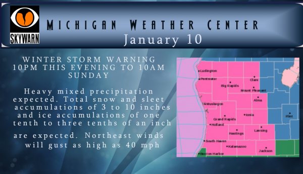
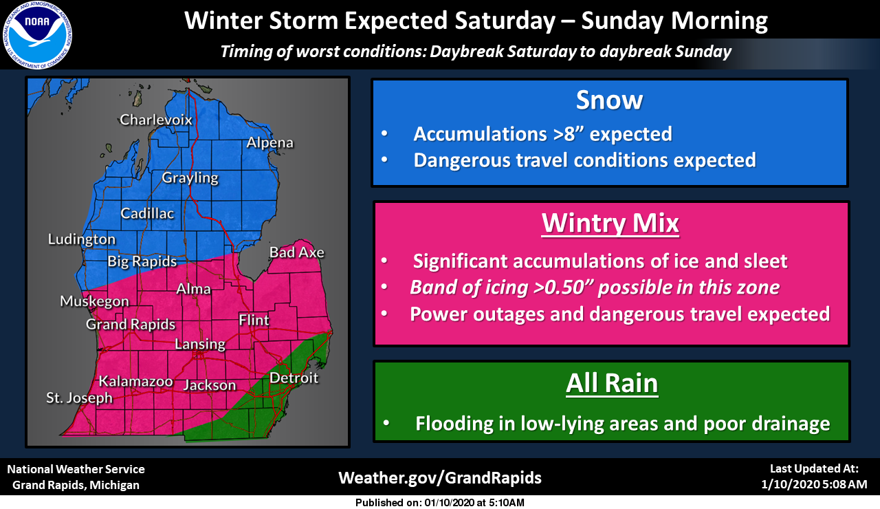
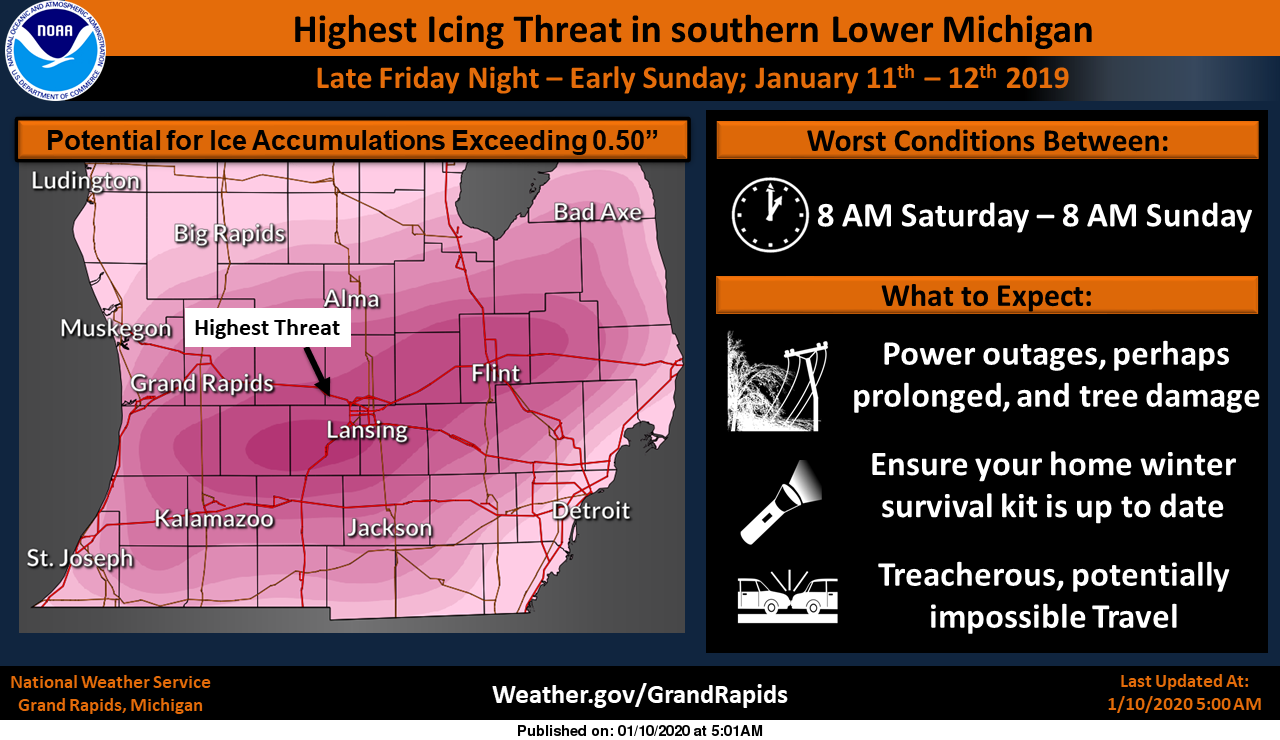
Northwest of a line from Whitehall to Clare, the full transition to
snow is expected to occur by sunrise. Up to one tenth of an inch of
ice and 6 to 10 inches of snow is expected (note the Winter Storm
Warning is broken up differently so the numbers may not match
exactly). Travel will be impacted with blowing snow and falling
temperatures making snow accumulations and removal on roadways
difficult.

Across central Lower Michigan (roughly along I-96), the transition
will begin by sunrise and stall at sleet. Up to one half inch of ice
and 1 to 3 inches of sleet is expected. Falling tree limbs and power
outages are likely especially if the ice accumulations are realized.
Travel will become extremely difficult as sleet has more water
content than snow making it harder to remove and inherently more
slippery. The worst travel impacts are expected in this zone.

Across the south (roughly along I-94), the transition will begin by
mid-morning and stall somewhere between freezing rain and sleet.
This is where the most freezing rain is possible, with a half inch
to three quarters of an inch of ice and 1 inch of sleet possible.
Considerable tree debris and prolonged power outages are likely
especially if the higher-end ice accumulations are realized. Travel
impacts are likely due to at least modest ice accumulation even if
road temperatures start off warm. As much as 2 to 3 inches of liquid
rain may fall before changing to a wintry mix as well, leading to
flooding of low-lying areas and roadways and rapid rises in rivers.
It`s worth noting the ECMWF ensemble shows a 100% chance of at least
2 inches of rain in this zone, which is absolutely remarkable
considering the normal January rainfall in Kalamazoo and Jackson is
1.79" and 1.49", respectively.
There is still some model disagreement as to the passing of the low – the WRF-ARW shows everything shifting south which would give us all snow – regardless this could be a storm for the history books. That said the best place to be would be snuggled up at home with the wife and kids.
Luckily we have a generator to provide heat with our electric fireplace and keep the freezer and fridge going – we also have gas to cook with. If the power goes out here so do the updates and posts so be aware of that if you don’t hear from me. Be safe!
[columns] [span6]
[/span6][span6]
[/span6][/columns]
Here is our interactive radar and forecast for you area:
Check out the forecast discussion. They really backed off on the ice, thank goodness: *** Freezing Rain is forecast – but major ice storm is unlikely for our area *** Pcpn type a little further south along the I-96 corridor will begin to transition from rain to freezing rain and sleet during the mid to late morning hours (around 14Z to 16Z) as increasingly brisk nne winds advect low level colder air in. Significant impacts from freezing rain (and sleet) are forecast with potential for freezing rain accumulations of around a quarter to perhaps a third of an inch near… Read more »
I just walked to the business college and the conditions have definitely worsened over the past hour though. Still not certain we are clear of the ice yet.
Am I the only one staying up for this storm?!?!! Sprites are going down nice!
Lol!! Looks like Bill jumped into the wishcasting! He just said GR will have 11.5 inches of snow by Sunday Morning! I’ve marked that down along with Rocky’s 16 inches of snow for GR by Sunday morning from yesterday. We shall see what the official GRR airport totals add up to come Monday morning.
This is the single worst weather event we could receive during this “season”…
Latest NWS update: 00z Model runs are just coming in. Present indications are that rain will commence shortly from southwest to northeast and continue overnight. Freezing rain is expected to develop near the I-96 corridor shortly after daybreak. We`re not going to change our expected ice accumulation totals at this point as there is a wide spread in the models with respect to total freezing rain accums. We do believe there will be some sleet mixed in as well. The key to this is how quickly the cold air rushes in from the north Saturday morning. Most models suggest this… Read more »
You know this is a wicked storm when in Arkansas there is a tornado warning for one county and an ice storm warning for the next door county.
P.S. RIP Neil Peart
I don’t like this storm’s track at all…. our area is in the bulls eye for mostly ice. I am prepared as best as I can w/o a generator. Freezer should be good for a couple of days, therefore if my church maintain power… may have heat as needed and running water source not too far away 😉 I have never prepared for something like this and I hope all my efforts are wasted…LOL!! Best of luck to you and your family!! Attempted to post a couple of times today but wasn’t able to for some reason..
I’m concerned about this one. Praying for the best. Good luck to you too,
Sheri.
Does anyone have links to the latest runs of the NAM, Euro, or GFS?
Try this site.
http://www.midwestweather.org/p/blog-page.html
Awesome! Thanks and be safe out there.
Breaking weather news>>>>the newly released cpc outlooks are awesome if you like cold and snow! Winter is here and should be around for at least 2+ months! I love it!
Well looks like I have the rest of the weekend off, and not from the storm. Part of our roof collapsed at work. Not going to be good with 2 or 3 inches of rain on the way.
At least it happend before u took over.. maybe u get a new roof before u buy it!!!
Exactly what I said!
This is just the start of Winter storms for west Michigan we have several more on the way and temps even in the 20’s next week prepare now ….INDY
My liver will be thanking Mother nature cause I’ll be busy plowing lol!!!
Yes you will Wild Bill..INDY
Becoming foggy with drizzle at 4:30 – temp is 48 degrees. Cadillac is at 37* and low 30s in the U.P…. Wisconsin is in the 20s and the Dakotas in the single digits – to the south temps are in the 50s and low 60s. Quite a difference…. Here is the 3pm NWS update: Rain will move into this evening through tonight for Central and Southern parts of the CWA. The surface flow turns northerly during this period and that will draw down a sub freezing airmass through most of the CWA by noon Saturday. This will result in a… Read more »
Is there any reason our station never uses Ice Storm Warnings? I was telling some of my project team members earlier that we have a Winter Storm Warning and they were all asking how much snow we would receive.
The Detroit office issued an Ice Storm Warning. Perhaps the offices will coordinate with each other later as we approach the event?
Well, the local ski resorts have been decimated again – and that’s before all this rain coming. This has been an awful winter locally for any kind of recreating from skiing to snowshoeing to ice fishing.
It has gotten very foggy here the temp is still warm at 47
Slim
Here as well. Visibility has dropped almost under a quarter mile. Here’s a pic looking over Chicago Drive:
https://www.flickr.com/photos/184860862@N07/49363763377/in/dateposted-public/
NWS latest Update: The 12Z mesoscale models are still showing some disagreement on the magnitude, timing, and location of the heaviest precip waves on Saturday, most likely due to differences in how they handle regionwide convection and its feedback into mass and momentum fields. But the general idea remains the same: The heaviest precipitation swath would be in a broad zone between Kalamazoo and Lansing, possibly including Jackson. Storm-total precipitation amounts of 3-4 inches would approach records for Dec-Jan-Feb, in competition with February 20, 2018. Fortunately this time around we are not melting a snowpack over frozen ground, but saturated… Read more »
3-4” of precipitation? WOW.
At this time it is warm over much of Michigan with temperatures well above freezing in lower Michigan. State wide they range from 50 at Detroit to 19 at Ironwood. Here at my house I now have 47.
Slim
Trouble on top of trouble…best of luck everybody. The winter forecast was “catastrophic”…
NWS GR has issued an update in their forecast discussion. Here’s an excerpt:
Still possible for an area to receive 0.5 to 0.75 inches of glaze ice by Saturday evening, most likely from Hastings to Lansing (with risk of it occurring to the north or south by 15 miles). Areas with moderate to heavy icing on trees and power lines are most at risk of long duration power outages as the winds increase Saturday evening.
3/4” of ice would be catastrophic.
You know I do not recall the NWS have before trying to pinpoint a forecast with a small 15 mile window before. Will have to see if that is something new or just some fancy footwork.
Slim
Agreed. We were in the bullseye yesterday too. In fact, the forecast from days ago really hasn’t changed much. Nice work, NWS.
Gale warnings out on lk Michigan shuuh any ice build up could mean catastrophe and trees and power lines ..INDY
Blizzard conditions Saturday evening not out of the Question for Grand Rapids now with the lastest MODLE runs … amazing..INDY
For Kalamazoo Co: Tonight Rain. Low around 36. Light and variable wind becoming northeast 5 to 10 mph in the evening. Chance of precipitation is 100%. New precipitation amounts between 1 and 2 inches possible. Saturday Rain before 11am, then freezing rain. The rain and freezing rain could be heavy at times. Temperature falling to around 31 by 3pm. Breezy, with a northeast wind 11 to 20 mph, with gusts as high as 37 mph. Chance of precipitation is 100%. New ice accumulation of around a 0.3 of an inch possible. Saturday Night Freezing rain and sleet, possibly mixed with… Read more »
For Ionia Co: Tonight Rain. Low around 31. Light northeast wind becoming north northeast 9 to 14 mph in the evening. Winds could gust as high as 26 mph. Chance of precipitation is 100%. New precipitation amounts between three quarters and one inch possible. Saturday Rain or freezing rain before 10am, then sleet, possibly mixed with freezing rain. The sleet could be heavy at times. Temperature falling to around 29 by 10am. Breezy, with a northeast wind 15 to 22 mph, with gusts as high as 40 mph. Chance of precipitation is 100%. New ice accumulation of around a 0.4… Read more »
For Kent Co: Tonight Rain. Low around 32. Light northeast wind becoming north northeast 6 to 11 mph in the evening. Winds could gust as high as 28 mph. Chance of precipitation is 100%. New precipitation amounts between three quarters and one inch possible. Saturday Rain or freezing rain before 10am, then sleet, possibly mixed with freezing rain. The sleet could be heavy at times. Temperature falling to around 29 by 11am. Breezy, with a northeast wind 14 to 20 mph, with gusts as high as 39 mph. Chance of precipitation is 100%. New ice accumulation of around a 0.3… Read more »
So much hype on here. Thanks for posting the facts!
Yes the warm weather hype has been off the charts!
For Allegan Co: Tonight Rain. Low around 33. Light east wind becoming north northeast 9 to 14 mph in the evening. Winds could gust as high as 24 mph. Chance of precipitation is 100%. New precipitation amounts between 1 and 2 inches possible. Saturday Rain or freezing rain before 2pm, then freezing rain and sleet. Temperature falling to around 30 by 11am. Breezy, with a northeast wind 14 to 23 mph, with gusts as high as 40 mph. Chance of precipitation is 100%. New ice accumulation of around a 0.4 of an inch possible. New sleet accumulation of less than… Read more »
Here is an interesting article from iWeathernet
https://www.iweathernet.com/tips/beware-snowfall-accumulation-screenshots-many-days-advance#beware
No matter how good a forecast is none are written in stone and subject to change. Even this weekend’s forecast could change before the end.
Slim
just a reminder of using wishcasting or other data other than the reputable weather services so as not to confuse those looking for an accurate forecast – or as accurate as can be determined with current data…
Thank you for the facts! Unfortunately, we’ve seen this very thing from several on this blog.
Yes the warm weather hype and talk of no winter has been off the charts!
Pretty sure the wishcasting he is referring to would be the maps showing us getting 48 to 60 inches of snow over the next few days. Those are beyond hype.
You are correct, Barry.
Like I said the warm weather hype form a few on here has been ridiculous!
I think you need to actually read what MV posted.
Found a weather map on twitter that shows a few isolated areas in sw michigan where precip may start out as $10 bills. Don’t ask where… I’m not tellin.
Storm chase
Slim
geez, that throws a wrench into the forecast – I don’t have the graphics for that one 🙂
I think the biggest concern for this weekend are any ice and the wind. IF the ice is as much as in the forecast this would be one of the worst ice storms in southern Michigan history. On the good side is that it will be warm today and warm at the start of the event and during the day. The bad is that the temperatures will fall into the 20’s and the winds if they occur will not help. So at this time I would say hope for the best and be prepared for the worst. And by the… Read more »
At least next week still looks very mild, so any extended power outages won’t be like last year when temps were in the teens. Don’t have to worry about pipes bursting or extreme cold.
I can remember that there were power outages last year but for some reason I can not find the dates. The only power outage I had last year was in the summer time. But if this plays out in the worst case there could be a widespread power outage more like in April 2003 and March 1976. But we shall see maybe there will be more just rain and not as much ice.
Slim
Lots of snow potentials coming after this storm next week amazing January looks to end up above average snow now from what the MODLES show … WINTER STRIKES BACK we will call it love it …INDY..
January is +8.7 degrees above average. Further, January is almost 7″ below average snowfall and we are about 15″ below average snowfall for the season.
Lol we could get 15 inches of snow by Sunday wow ….INDY
Nope
You know it! The maps are a beautiful sight and the temp trends are also fantastic! Winter is here and no looking Back!
https://www.instantweathermaps.com/GFS-php/conussfc.php?run=2020011006&time=PER&var=ASNOWI&hour=384
Wow, FIVE FEET of snow up by Alpena!!!!
Just kidding. This is one of those maps Michael’s article talks about.
Yeah, that’s the fantasy land map created by fifth graders!
Wow – hit 49 degrees last night! Sure feels like an early spring morning out there today. You wouldn’t know this is supposed to be the dead of winter. Hoping for some thunderstorms this weekend! After this weekend, NWS mentions the possibility of more thunderstorms later in the week too. Unbelievable!
It was 49 for the much of the night and at this time all of the snow in now gone in my area even the snow piles. I am sure the snow piles are still there in the big parking lots but that is just about it. The first 9 days of January 2020 Grand Rapids has only has 0.4″ of snow fall. And for the season GR is now over 14″ below average.
Slim
The latest NWS GRR forecast model track they posted on Twitter shows very little to no snow for GR south now. More like rain then ice then sleet.
Can that ice map be any worse? Probably, but still. 🥶
Yeah it doesn’t look so great for your area.
Gassed up the genny just in case for this one!
The most impressive item in that discussion is the 100% chance of 2 inches of rain. Don’t see that very often, and certainly not in January! Very mild morning again at 48 degrees. Smells like Spring again.
My thoughts now GR will get 6 to 10 inches of snow by Sunday with winds gusty to 45mph Saturday evening will call for blizzard conditions this is going to be a nasty winter storm get to the store and grab more many people will lose power and we have another storm coming next week racking tracking and stacking time have a great Friday …INDY…
Wow and that is quite a prediction! We still need this baby to track a little farther south and east! We know we will be getting a storm however the details are still up in the air?