

West Africa Geography Information (Photo: )
West Africa is the continent’s westernmost region and is near the north, just under the Maghreb nations of Morocco, Algeria, Tunisia, and Libya. The nation that gets bandied about between both West Africa and the Maghreb, depending whose definition you go by, is Mauritania.
Aside from Mauritania, West Africa includes 15 countries – Benin, Burkina Faso, Côte d'Ivoire, Cape Verde, The Gambia, Ghana, Guinea, Guinea-Bissau, Liberia, Mali, Niger, Nigeria, Senegal, Sierra Leone and Togo.
This is a vast, tropical region sprawling over more than 5 million square miles. Its borders include the Atlantic Ocean in the west and a part of the Sahara Desert called the Ranishanu Bend as the northernmost point – which is part of the reason for the “is it or isn’t it?” confusion on Mauritania, as this divider crosses the bottom third of Mauritania. The eastern border is a bit disputed – some say it’s the Benue Trough, part of the Central African Rift, and others say it’s a line stretching from Mount Cameroon to Lake Chad.
The Historic Coasts
West Africa’s coastline plays a huge role in Africa’s story. It’s here one finds the Slave Coast, the Ivory Coast, the Gold Coast, and the Pepper Coast. Sitting under Europe and with the Suez Canal not yet built, from the 1400s on this region was Europe’s go-to for exotic trade – a landscape where one found gold, peppers and other coveted spices, elephants for ivory and, sadly, yes, slaves too.
Of the West African nations, only Niger, Burkina Faso and Mali are landlocked, and the rest meet the Atlantic Ocean. The coasts frequently have sandy beaches, backing up onto low cliffs and rock forms. Its oceans can be as azure as the Mediterranean Sea. And, notably, Senegal is considered to have some of the continent’s best surfing spots.
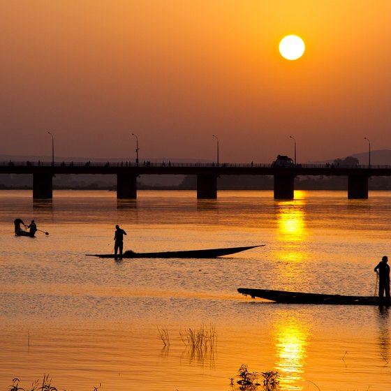
Where there’s coast, there’s fish. West Africa’s are still generally working beaches, where fishermen row out to sea every morning for the catch of the day. But you’ll find these lush African coasts offer plenty of sport fishing for travellers in countries like The Gambia and Sierra Leone, where deep-sea fishing is big business in the Banana Islands.
Up North, in the Sahel
The start of the Sahara is the northern border for West Africa, and just below it is the Sahel, a transitional semi-arid landscape that separates the desert from the savanna grasslands. Unfortunately desertification is happening here, due to land overuse, drought and deforestation, which means the land is slowly turning from semi-arid to arid and joining the inhospitable Sahara.
But for now it’s a landscape that comes alive in the rainy season, turning verdant and fresh. Soon after, it’s consumed by wildlife and locals. Trees that thrive here include the acacia and what is one of the world’s most interesting trees, the drought- and fire-resistant baobab tree, whose trunks can be 50 feet wide and tops look like broccoli crowns.
While the Sahel is narrow north to south, the east-west path of this transitional terrain extends 3,300 miles across the continent, from Senegal to West Sudan.
The Highs and Lows in West Africa
The entire West African region is fairly low, and most of its high points are around 5,000 feet, but the highest mainland mountain is 6,381 feet, in Senegal. However, most of the landscape is below 1,500 feet altitude.
It gets higher offshore where, on the tiny island nation of Cape Verde, Pico do Fogo is a volcano popular with trekkers, which reaches 9,281 feet.
On the southwestern edge, West Africa meets the Cameroon Highlands. Throughout the southeastern West African nations near Cameroon are some mountains and solitary high plateaus in Côte d'Ivoire, Guinea, Liberia, Nigeria, Sierra Leone and Togo.
Most of the region is largely underlain with crystalline rock, making it a hot spot for the diamond and salt industries.
Waterways of West Africa
The Niger is the dominant river of West Africa. This boomerang-shaped river is Africa’s third-longest, after the Nile and Congo, running a distance of 2,600 miles through Nigeria, Niger, Benin, Mali, and Guinea. Its source is found in the Guinea highlands and it ends in the sprawling Niger Delta. In the delta, an area the size of Belgium forms marshes, braided streams, and small lakes, making this a terrific destination for fishing.
The Benue is the largest tributary of the Niger River. Two other notable river systems include the Senegal River, which serves as a 675-mile marker for the border between Senegal and Mauritania. You can do a 7-day cruise on the Senegal with an old French colonial steamer called the Bou El Mogdad. Finally, the Volta is a 1,600-mile river originating in the highlands of Burkina Faso and spilling down into Ghana.
A Few Great Destinations in West Africa
If looking for unique experiences in West Africa, any trekker must consider visiting the Dogon country in Mali, famous for the incredible tiny mud brick houses, some dating back to the 1400s, stacked impossibly on cliff faces. Hire a guide for the trek of a lifetime, which can be between 2 and 10 days.
In Sierra Leone, sign up for a guided trek to the “roof of West Africa,” Mount Bintumani, which hits 6,381 feet in the Loma Mountains.
A safari is one of the ultimate African experiences, and Yinkari National Park in Nigeria is filled with savannas, rolling hills, and wild animals in their natural habitat – one of the few remaining West African places to see animals where they really belong. It’s here where you’ll find Africa’s largest herd of elephants -- over 350 – and warthogs too!
If all that adventuring wears you out and you need a few days at a beach resort, consider ending your adventure at Cap Skirring in Gambia, a popular getaway spot with sandy beaches, palms, and resorts of all levels.
References
Resources
Writer Bio
Steffani Cameron is a freelance writer and journalist with bylines in Washington Post, Canadian Traveller, and many other sites. In 2015, she sold everything to go nomad and has since slow-travelled alone through over 24 countries while working remotely. Her highlight was having Pula, Croatia's Roman Coliseum all to herself one windy November day. She blogs her adventures periodically at FullNomad.com.