
At a Glance
- NOAA's Storm Prediction Center issues outlooks for severe weather every day.
- High-risk outlooks are very rare.
- They indicate either a tornado outbreak or widespread destructive winds are expected.
Sign up for the Morning Brief email newsletter to get weekday updates from The Weather Channel and our meteorologists.
A "high risk" severe weather outlook is one of the most urgent messages NOAA's Storm Prediction Center (SPC) can give hours before a severe weather outbreak.
Only issued by the SPC when there's high confidence in a volatile setup of severe weather for any given day somewhere in the country, high risks catch the attention of meteorologists every time.
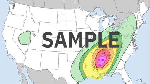
It's the highest level of severity on a scale from 1 to 5 in daily severe weather outlooks issued by the SPC.
(MORE: What the SPC's Risk Categories Really Mean)
When the nation's best severe weather forecasters issue such a high risk, they're concerned about one of the following in the area, according to the SPC website:
- A tornado outbreak with numerous intense and long-tracked tornadoes.
- A long-lived derecho-producing thunderstorm complex that produces hurricane-force wind gusts and widespread damage.
Documentation on past high-risk outlooks is most thorough for those issued this century, but there were also documented cases in the 1980s and 1990s.
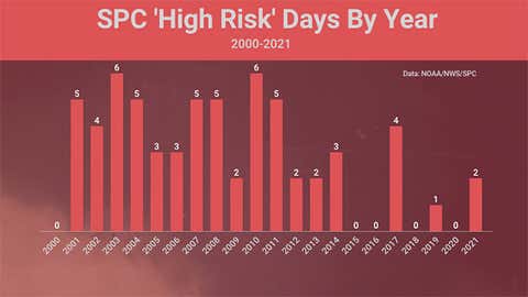
Only a Few Each Year
From 2000 through 2021, the SPC issued a Level 5 high-risk forecast an average of two to three days each year.
The last two high-risk forecasts were issued on March 17 and March 25, 2021, in the Deep South.
Both 2003 and 2010 had the most in any year – six – while a few recent years didn't have a single high risk, including 2020. From June 2014 until late January 2017, no high risks were issued, the longest stretch this century.
Two Dangerous Months
April and May combined to account for nearly two-thirds of all high-risk days from 2000 through 2021, with 21 and 19, respectively. These months frequently have the right volatile mix of enough warm, humid air overlaid by a still-active spring jet stream.
There have been high-risk outlooks issued in the fall and winter months, including a first-ever January high risk in 2017.
Only August and September haven't had a single high-risk outlook. In those months, the jet stream required to prime the atmosphere for large-scale tornado outbreaks or large-scale convective wind-damage events is usually not strong enough.
That's not to say you can't get a rash of tornadoes during a landfalling hurricane, for example, in those months, as we saw with Hurricane Ivan in 2004.

Either in Plains, Midwest or South
This century, all high risks have covered either parts of the Midwest (Mississippi Valley, Ohio Valley, Great Lakes), Plains (Dakotas to Texas) or South (Arkansas and Louisiana to Virginia and the Carolinas).
Here is the breakdown of regions covered by each of the 63 high risks from 2000 through 2021 (some high risks covered multiple regions, so the total below will be greater than 63).
- South/Gulf Coast: 29
- Plains: 26
- Midwest: 22
- Northeast: 0
- Rockies and West: 0
However, one high risk was issued for parts of the Northeast in association with one of the most prolific derechos of recent times – the May 30-31, 1998, Great Lakes and Northeast derecho.
A Solid Track Record
We examined each of the 63 high-risk outlooks from 2000 through 2021 to determine how many of those forecasts rang true to the dire nature of the outlooks.
There are various shades of gray in assessing the accuracy of these forecasts, somewhat analogous to grading the drafts of professional sports teams years after the fact.
Almost three-quarters (46) of the high-risk forecasts were solid.

These not only included obvious cases, like the late-April 2011 Super Outbreak, but also some tougher, more out-of-season forecasts, such as the November 2013 Midwest outbreak and the February 2008 Super Tuesday outbreak.
Only seven of these high-risk forecasts could be clearly categorized as busts, primarily from a lack of tornadoes in the high-risk zone.
As SPC forecasters explained in a discussion regarding the May 18, 2017, high risk, a number of factors, such as too many competing severe thunderstorms interfering with each other, can lead to a busted forecast.
The most recent example of this was on April 27, 2014, when a small part of Arkansas was highlighted in the afternoon, but relatively few tornadoes occurred in that zone.
The other 10 cases weren't clearly either a hit or bust.
One example was April 5, 2017, in the Southeast. The high risk issued around midday certainly seemed to capture a long-track supercell spawning tornadoes in the southern half of Georgia. However, one could argue the density of reports of severe weather was higher in areas surrounding the high risk.
That case points out that while a high-risk area is typically denoted as "particularly dangerous" in the lexicon of meteorologists, you should still take lower level risk areas of severe thunderstorms seriously.
You can check the Storm Prediction Center's outlooks here.
Not Panic, But Preparation
"Due to the rarity of a high risk issuance, the response it generates is tremendous," SPC meteorologist Evan Bentley wrote in a tweet thread on Feb. 28, 2023.
"On the worst days we want people to take unprecedented action to protect themselves," Bentley wrote.
If your area is in a high risk of severe thunderstorms, the government's most experienced severe weather forecasters are confident of either a tornado outbreak or widespread damaging thunderstorm winds, and you should pay particularly close attention to the weather situation that day or night.
Have a dependable method of getting severe weather watches and warnings, whether through local media, NOAA weather radio, social media or a smartphone. Make sure your smartphone is charged and app settings, including volume, are such that you can be awakened from a sound sleep.
(MORE: Nighttime Tornadoes are Particularly Deadly)
Know where to take shelter if a warning is issued.

If you live in a mobile home, find out if your area has a safe shelter underground, or find somewhere else where you can take shelter ahead of time.
(MORE: Where to Go If Your Home Has No Basement or You're in a Mobile Home)
It is more likely in areas covered by a high risk that any tornado warnings will be for confirmed, large and destructive tornadoes, rather than false-alarms based on radar-indicated rotation alone.
Planning ahead for these dangerous severe weather days can save your life.
The Weather Company’s primary journalistic mission is to report on breaking weather news, the environment and the importance of science to our lives. This story does not necessarily represent the position of our parent company, IBM.


