


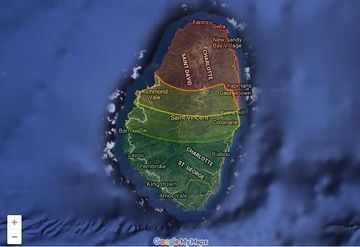
Soufrière St. Vincent volcano (St. Vincent Island, West Indies): Volcanic Alert Level lowered to Green
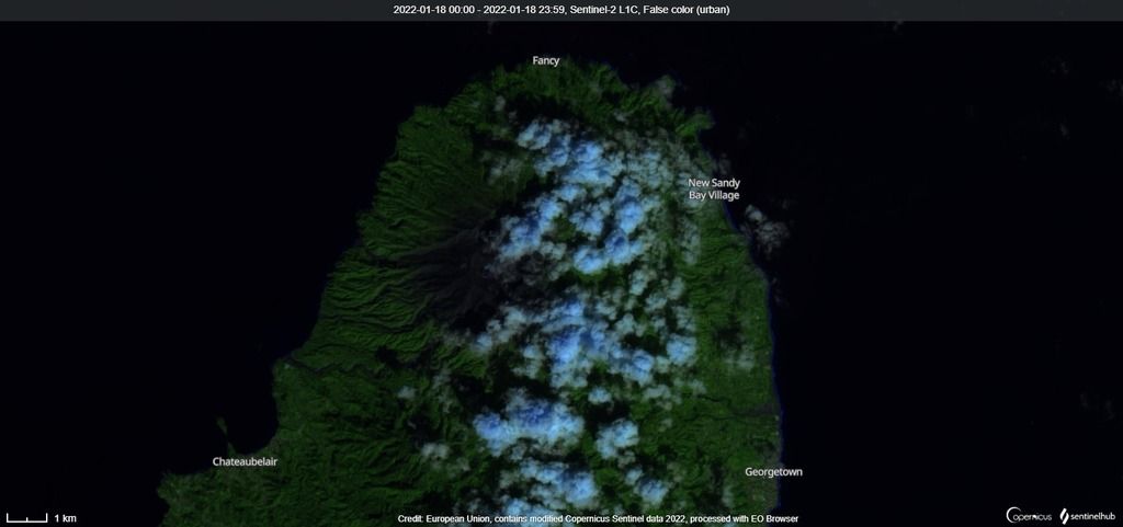
The activity at the volcano is now considered to be at levels similar to the activity prior to the 20-21 eruption.
The decreasing trend has continued over the past months.
No significant change in chemical composition has been observed since late January.
Source: University of the West Indies volcano activity update 17 March 2022
- All news about: Soufrière St. Vincent volcano
- Information about: Soufrière St. Vincent volcano
Soufrière St. Vincent volcano (St. Vincent Island, West Indies): eruptive phase ended
after almost one year of observations, when the new lava dome at the volcano was detected in December last year and are about to leave the local Belmont observatory.
The Soufrière St. Vincent volcano's activity continues at decreasing values since the last explosive eruption on 22 April and all monitoring data indicate the end of the eruptive episode.
Remaining gas and steam plumes and lahars will be monitored remotely from its base in Trinidad and Tobago.
The UWI-SRC's volcanologist prof. Richard Robertson said: “The mountain went through a traumatic experience and will take some time to reshape itself”.
The alert level for the volcano remains at "yellow".
Source: University of the West Indies volcano activity update 30 November 2021
- All news about: Soufrière St. Vincent volcano
- Information about: Soufrière St. Vincent volcano
Soufrière St. Vincent volcano (St. Vincent Island, West Indies): Volcanic Alert Level lowered to Yellow
The activity at the volcano has decreased over the past three months associated by continuous degassing from the summit vent.
Source: The University of the West Indies volcano activity update 16 September 2021
- All news about: Soufrière St. Vincent volcano
- Information about: Soufrière St. Vincent volcano
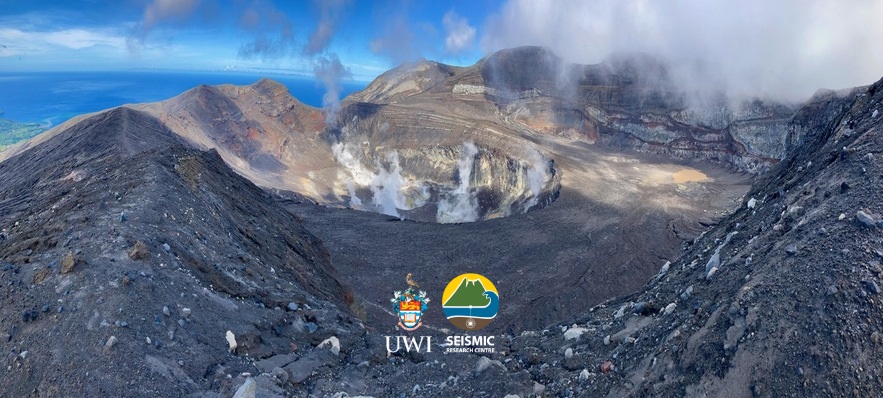
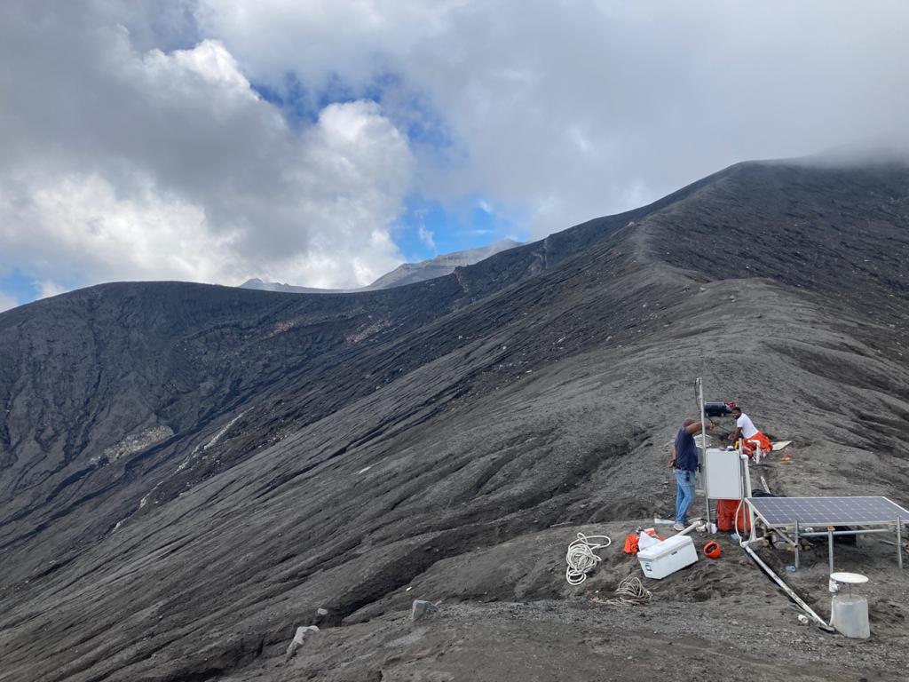
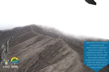
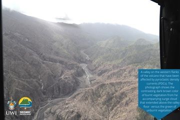
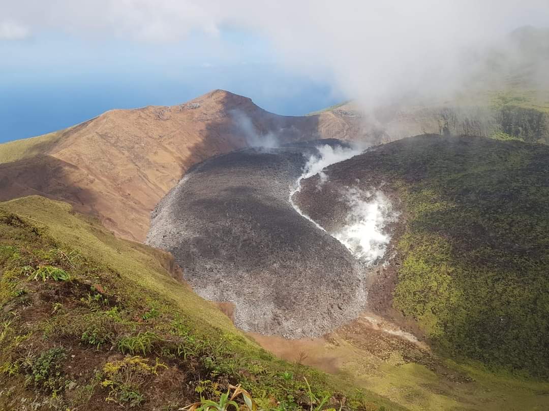
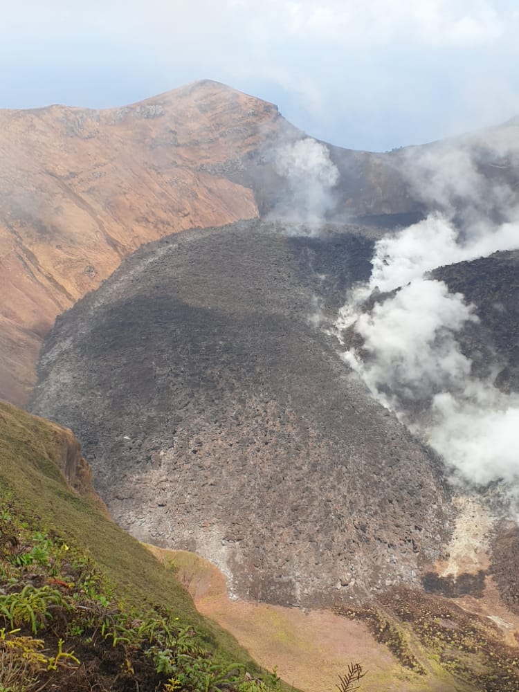
Soufrière St. Vincent volcano (St. Vincent Island, West Indies): new images of 2021 crater area and western flanks
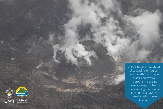
A look into the new crater shows several hydrothermal areas that are responsible for a continuous degassing.
A total destruction of vegetation can be observed on the upper slopes of the volcano related to massive eruptions during April this year. This area is currently covered by thick tuff layers (tephra/pyroclastic material deposits) where heavy rainfalls whittled new-formed V-shaped gullies.
They also took a picture of a valley on the western flanks of the volcano that has been affected by pyroclastic flows. This phenomenon is deadly, turbulent hot avalanche of lava rock fragments of all sizes embedded in a mixture of turbulent gas and ash racing down slopes.
In addition, no new lava dome is observed from available images.
- All news about: Soufrière St. Vincent volcano
- Information about: Soufrière St. Vincent volcano
Soufrière St. Vincent volcano (St. Vincent Island, West Indies): latest image reveals 2021 crater
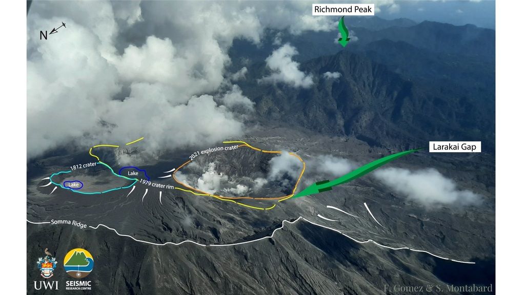
The crater is located next to 1812 crater as can be seen in the attached image.
The volcano continues at seismic unrest.
A near-constant gas and steam venting continues from the summit crater. Sulfur dioxide (SO2) emissions reached to a 461 tonnes/day on 20 May.
Satellite-based images confirmed that no actively growing lava dome appears within the summit crater at this moment and there is no indication that the volcano will return to a dome growing phase again.
- All news about: Soufrière St. Vincent volcano
- Information about: Soufrière St. Vincent volcano
Soufrière St. Vincent volcano (St. Vincent Island, West Indies): volcano remains at seismic unrest

A volcanologist Dr. Adam Stinton from the Belmont observatory noted: "Since the morning of Friday 21st, there have been a handful of earthquakes, just around 20-25. None of the earthquakes are large enough to be felt at the moment; the average per day is about 10-15 since the last explosion on April 22nd".
A near-constant gas and steam venting continues from the summit crater.
Satellite-based images confirmed that no actively growing lava dome appears within the summit crater at this moment and there is no indication that the volcano will return to a dome growing phase again. Judging from the attached image, an uplifted area in the inner summit crater may indicate either extruded magma towards the surface or tephra accumulation immediately after the last eruption.
According to NASA FIRMS a high thermal anomaly continues to be detected within the summit crater.
Sulfur dioxide (SO2) emissions reached to a 461 tonnes/day on 20 May.
The Volcanic Alert Level remains at Orange.
Source: News 784 25 May 2021
- All news about: Soufrière St. Vincent volcano
- Information about: Soufrière St. Vincent volcano
Soufrière St. Vincent volcano update: Volcanic Alert Level lowered to Orange
NEMO bulletin cites further:
"An orange Volcano Alert Level means that the volcano may resume explosions with less than twenty-four hours'notice. As a result of this, the Government of St. Vincent and the Grenadines have also taken the decision that residents of communities in the orange zone from Petit Bordel to Gordon Yard on the Leeward side of the island and up to Mt. Young near the RUBIS Gas Station on the Windward side of the island, can return home and carry out normal activities."
Lahars (mud flows) could continue to occur if heavy rainfalls remobilise the fresh ash deposits in valleys including Wallibou and Rabacca valleys.
Source: The University of the West Indies volcano activity update volcano activity update 7 May 2021
- All news about: Soufrière St. Vincent volcano
- Information about: Soufrière St. Vincent volcano
Soufrière St. Vincent volcano update: heavy rainfalls triggered lahars
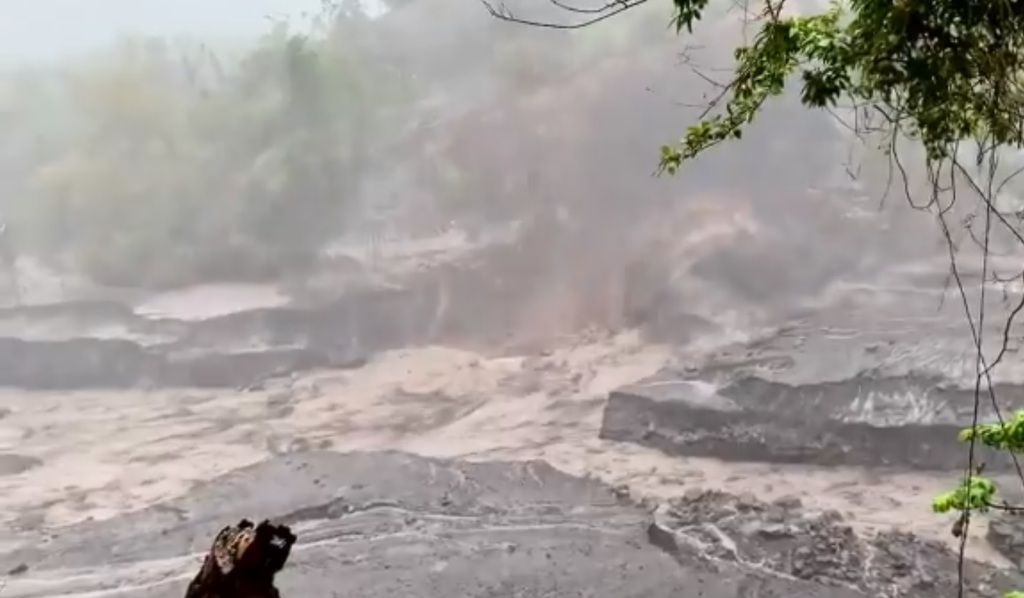
After a series of heavy rainfalls at the island, a few lahars (mud flows) occurred in many valleys as fresh ash deposits from explosions have been remobilised which are expected to threaten inhabited areas.
As the National Emergency Management Organization (NEMO) noted, residents especially in the Yellow, Orange and Red Zones should avoid areas within the vicinity of rivers due to destructive lahars (mud flows).
Source: The University of the West Indies volcano activity update 5 May 2021
Big and hazardous lahars in Wallbou valley on 3 May (source: @PaulCole23/twitter)
Big and hazardous lahars in many valleys on #lasoufrière today. Here is one we witnessed in the Wallbou valley today. @uwiseismic @NEMOSVG pic.twitter.com/SWyv0uRFCZ
— Paul Cole (@PaulCole23) May 3, 2021
- All news about: Soufrière St. Vincent volcano
- Information about: Soufrière St. Vincent volcano
Soufrière St. Vincent volcano update: eruption plumes travel around the world

A GIF animation depicts the volcano's SO2 emissions traveling around the world (source: @PlatformAdam/twitter)
Here the Gif from April 10 to 20 of SO2 emissions from #LaSoufrière eruptions. #volcano #svg #monitoring @uwiseismic @CultureVolcan pic.twitter.com/2Gmz9hfGJC
— ADAM Platform (@PlatformAdam) April 22, 2021
- All news about: Soufrière St. Vincent volcano
- Information about: Soufrière St. Vincent volcano
Soufrière St. Vincent volcano update: vigorous eruption yesterday

After 90 hours since the last eruption, another spectacular vulcanian explosion occurred at 11:08 local time yesterday.
An increasingly large dense ash plume rose nearly to troposphere boundary up to 9,1 km altitude. The eruption column drifted most often W direction, but some ash particles reached Saint Lucia Island. Most of the material seems to be going out towards the sea.
Source: The University of the West Indies volcano activity update 23 April 2021
3-hours animation of the eruption plume from the satellite (source: @tonyveco/twitter)
New explosive eruption today at #LaSoufrière #Volcano around https://t.co/MskIo45C6S the 3-hours animation of #GOES16 starting at 14:40UTC,showing the ash product(by @eumetsat ) mainly flying to W direction and small part towards #SaintLucia island. #EarthDay2021 #SVG @wmo pic.twitter.com/LukGkpAjmi
— antonio vecoli (@tonyveco) April 22, 2021
- All news about: Soufrière St. Vincent volcano
- Information about: Soufrière St. Vincent volcano
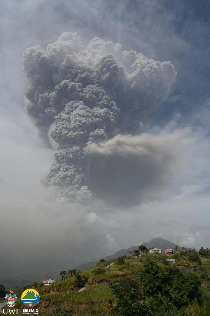
Soufrière St. Vincent volcano update: major eruption yesterday
After more than 2 days since Friday's eruption, another strong explosive episode from the volcano's summit crater occurred yesterday.
A major explosion started around 16:49 local time. A typical tall and dense ash plume rose to estimated 3 km altitude and drifted south and west.
The alert level for the volcano remains red.
Source: The University of the West Indies volcano activity update 19 April 2021
Volcanic ash is dispersed towards the south and west (source: @tonyveco/twitte)
New major eruptive explosion started at #LaSoufriere #volcano around 20:49UTC,with ash & gases flying to the W and partially hitting #Bequia island to the Sout. Here a 2-hours animation of #GOES16 ash product (by @eumetsat )until 22:32UTC #SanVicenteYLasGranadinas #SVG @wmo pic.twitter.com/hCqH7ZneaA
— antonio vecoli (@tonyveco) April 18, 2021
- All news about: Soufrière St. Vincent volcano
- Information about: Soufrière St. Vincent volcano
Soufrière St. Vincent volcano update: eruption plumes continue to advance further E-SE Asia
- All news about: Soufrière St. Vincent volcano
- Information about: Soufrière St. Vincent volcano
Soufrière St. Vincent volcano update: powerful eruptions continue
An increasingly large plume reached up to an estimated altitude of 8,000 ft (2,400 m) as reported Volcanic Ash Advisory Center (VAAC) Washington.
The activity follows a pulsating pattern: Soufrière St. Vincent's tendency to produce such events in series at roughly regular intervals.
- All news about: Soufrière St. Vincent volcano
- Information about: Soufrière St. Vincent volcano
Explosive eruptions expected to continue
During the past 12 hours, the volcano has been in a calmer phase, but that might change soon again.
Eruption plumes drift thousands of kilometers

Earlier eruption plumes have been reaching Africa and the Middle East.
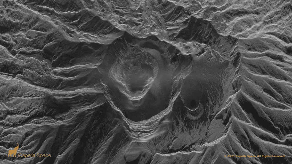
Amazing satellite radar image showing the new crater
UPDATE: Capella's 3D radar imaging captures the #LaSoufriere #Volcano dome collapse on St. Vincent. #SAR satellites can see through smoke and volcanic ash for 24/7 disaster response data. This 50cm very high-resolution image is from April 14, 2021 - 3:21pm UTC. pic.twitter.com/9Gq8rWOwDf
— Capella Space (@capellaspace) April 14, 2021
More detailed imagery of the new crater at the top of #LaSoufriere SVG. Impressive details (0.5 pixel size). The hole is likely several 100s meters deep. Imagery courtesy of @capellaspace. Acquired on 10 April 2021, 14:03 UTC. @uwiseismic @NEMOSVG pic.twitter.com/f1l0MBzO74
— Raphael Grandin (@RaphaelGrandin) April 13, 2021
Strong explosive phases continue, streches of coastline devastated by hot ash flows

Pyroclastic flows (hot turbulent avalanches of collapsing material from the eruption column) traveled down the Rabacca River towards the east coast and mud flows were observed in Sandy Bay area yesterday.
The activity seems to follow a pulsating pattern: Prior to the explosive phases, the volcano is comparably calm, but small volcanic earthquakes under the edifice are picking up until a new batch of magma arrives at the vent, leading to pulsating explosions lasting tens of minutes to few hours, accompanied by strong volcanic tremor. This activity gradually wanes to start a new cycle.
La Soufriere SCIENTIFIC UPDATE - 14/04/21 6:00AM #LaSoufrière #lasoufrière #svg #redalert #volcano #uwiseismic #uwi #stilldangerous @cdemacu @saintluciaNEMO @NEMOSVG @dem_barbados @GrenadaNadma pic.twitter.com/FwtRhGq4MN
— UWISeismic Research (@uwiseismic) April 14, 2021
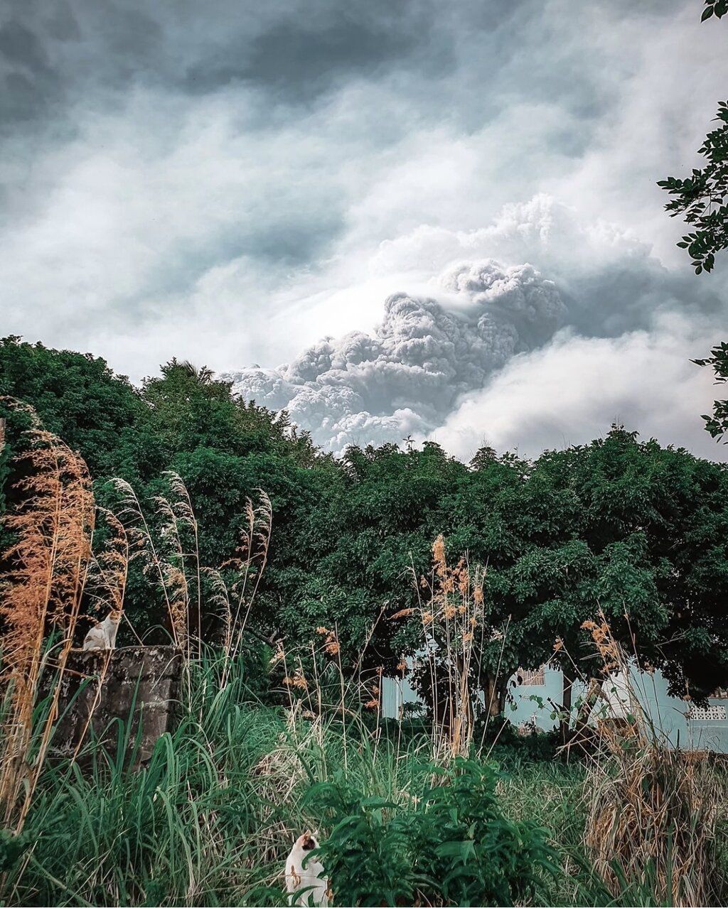
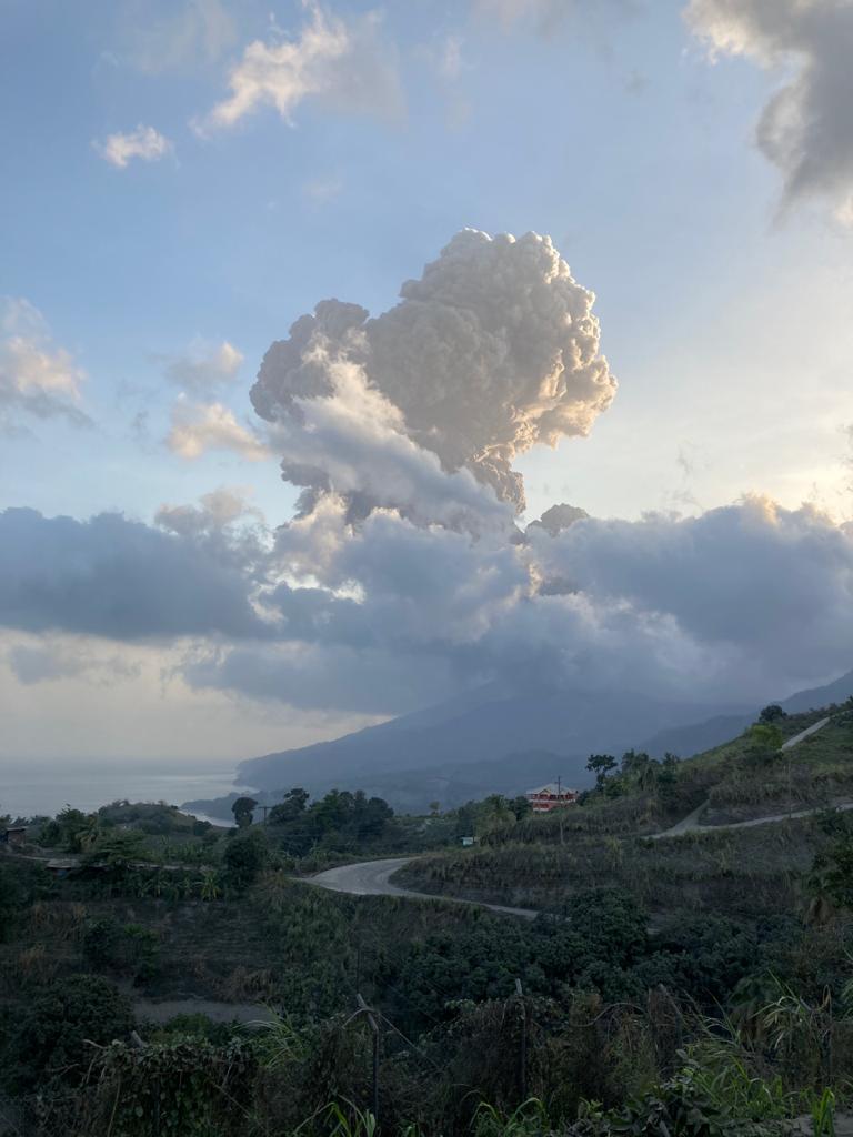
Soufrière St. Vincent volcano update: vigorous eruption sent ash up to 35,000 ft this morning
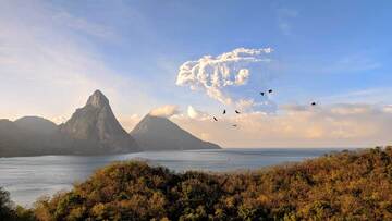
A spectacular dense and dark ash plume rose several kilometers above the summit crater up to troposphere boundary to an altitude of 35,000 ft (10,700 m).
The ash column was seen from the Jade Mountain Resort located on Saint Lucia Island about 60 km to the north as visible in the attached image.
Today's volcano explosion commemorates it's significant eruption exactly 42 years ago.
- All news about: Soufrière St. Vincent volcano
- Information about: Soufrière St. Vincent volcano
Soufrière St. Vincent volcano update: eruption calms down a bit, but risk of new explosions remains high
However, the risk of new large explosions remains high. The University of the West Indies (UWI) monitoring the situation detected a change in seismicity: "The pattern of seismic activity changed again, with the end of the episodes of high-amplitude tremor 2-8 hours apart."
From the latest update posted on Twitter:
"Three episodes of tremor have been recorded since 6am, two of them lower-amplitude and the third, at about 5pm, was high-amplitude.
"The episodes continue to coincide with periods of enhanced venting or explosive activity.
"Observations made indicate that pyroclastic density currents (PDCs) had descended several valleys on the southern and western flanks of the volcano and had reached the sea at Morne Ronde, Larikai and Trois Loupes Bay.
"Extensive damage to vegetation was noted in an area extending from Larikai Bay to Turner Bay on the west coast.
"No other areas along the coast had been affected by PDCs but villages located on the eastern flank of the volcano had been affected by heavy ashfall.
"Explosions and accompanying ashfall, of similar or larger magnitude, are likely to continue to occur over the next few days with the chance of PDCs occurring.
Link: Visit the International Volcanic Hazard Health Network for volcanic ash information resources: http://ivhhn.org/information10"
- All news about: Soufrière St. Vincent volcano
- Information about: Soufrière St. Vincent volcano
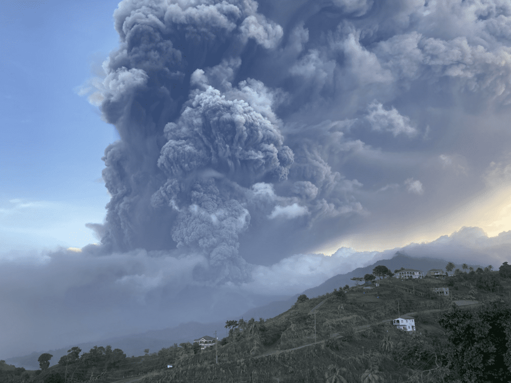
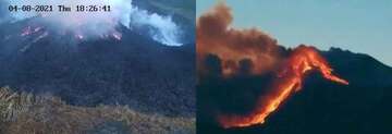
Soufrière St. Vincent volcano: massive explosion at night, dangerous hot avalanches reported
Pyroclastic flows were also reported - these are very dangerous, glowing turbulent avalanches of rock fragments and gas likely caused by collapsing parts of the eruption column that can travel many kilometers and destroy everything in their path. There is no data yet on how far and where exactly the pyroclastic flows traveled. We expect more information to come out in the near future, though.
The dome is confirmed completely destroyed. An important question to find out is whether the magma that has now erupted explosively is different from the one that had been building the dome during the past months, and how much of it is still left able to erupt in more explosions.
A speculation is that the previous magma that had been building the new (now gone) dome until recently was actually older, more or less degassed magma left in the conduit from the previous eruption in 1979, gradually pushed out by a new batch of gas-rich magma rising from depth, and erupting now.
The other possibility is that the dome had grown sufficiently to seal the conduit temporarily, causing magma underneath to form trapped gas bubbles, with increasing pressure, until it exploded, throwing the dome out like a champagne cork.
The sudden release of pressure would then open the upper conduit and allow gas-rich, foamy and viscous magma to rise quickly and erupt explosively.
A combination of both processes is a likely possibility as well.
Live updates from St. Vincent:
- All news about: Soufrière St. Vincent volcano
- Information about: Soufrière St. Vincent volcano
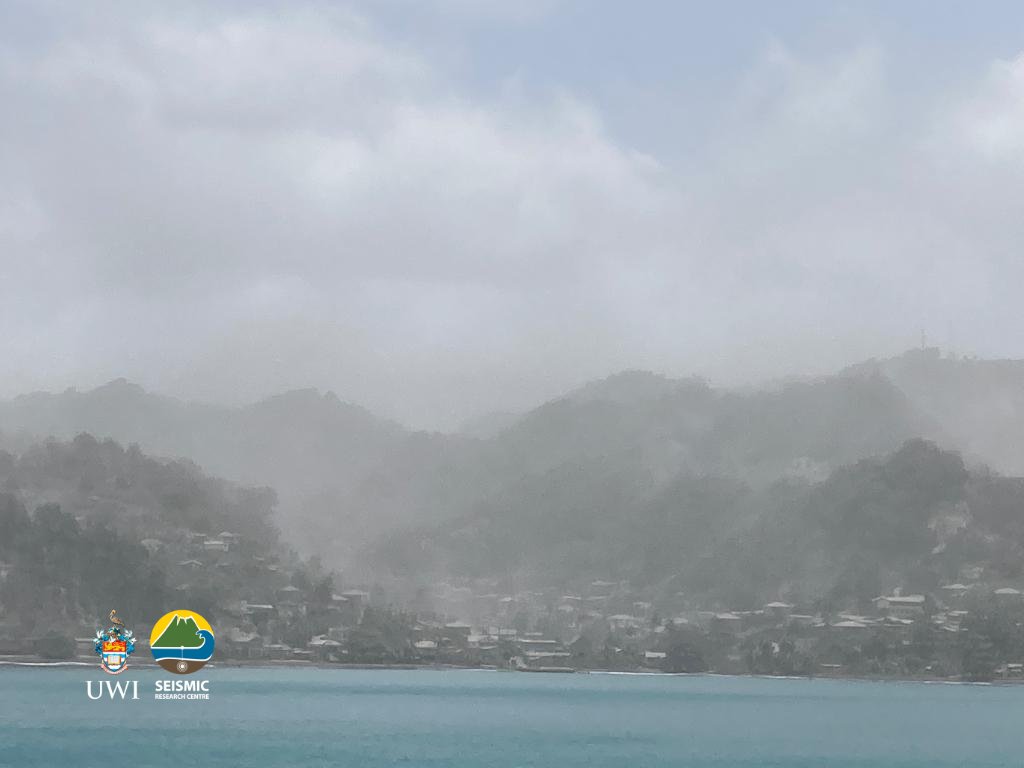
Soufrière St. Vincent volcano (St. Vincent Island, West Indies): heavy ash fall covered entire island
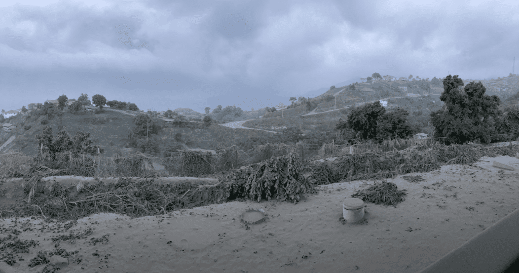
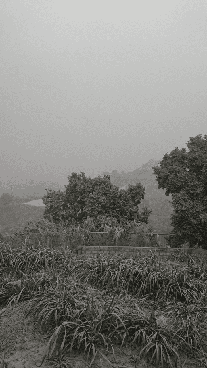
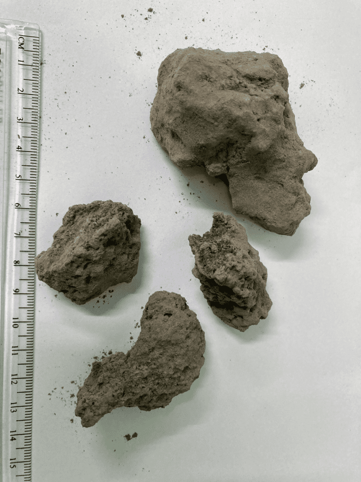
Strong ash and lapilli fall is occurring as far from the volcano as Argyle International Airport some 20 km away as National Emergency Management Organization (NEMO) reported.
A fresh scoria was also present in the ash collected at Rabacca river at about 7,4 km from the volcano.
More than 16,000 residents in "red zones" were urged to evacuate.
- All news about: Soufrière St. Vincent volcano
- Information about: Soufrière St. Vincent volcano
Soufrière St. Vincent volcano (St. Vincent Island, West Indies): dramatic changes to crater
- All news about: Soufrière St. Vincent volcano
- Information about: Soufrière St. Vincent volcano
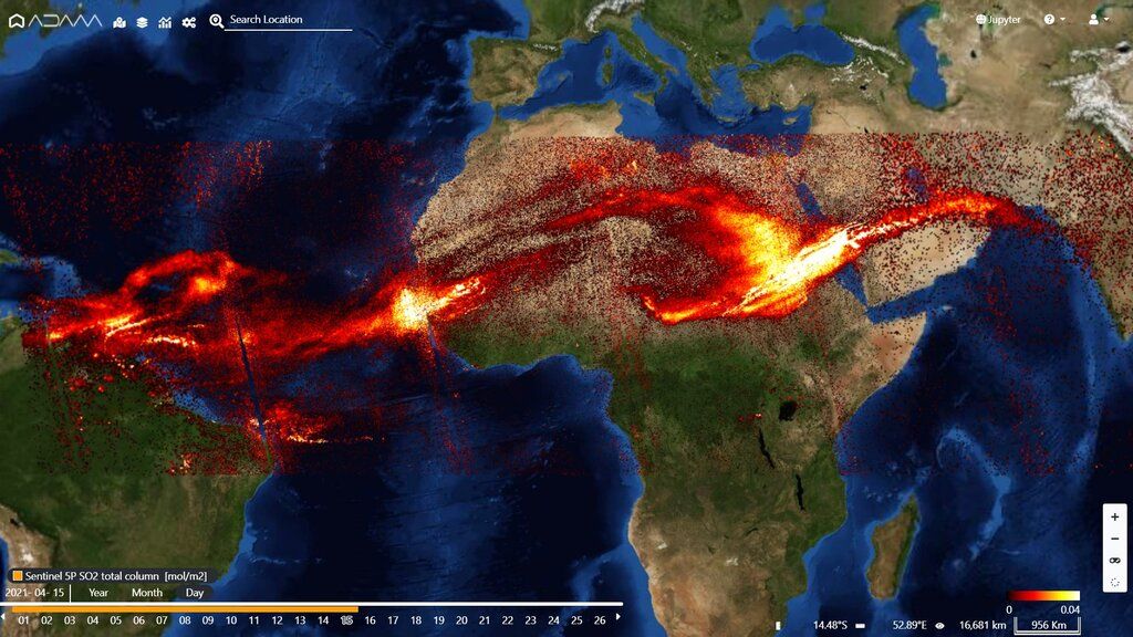
Soufrière St. Vincent volcano (St. Vincent Island, West Indies): powerful eruptions continue with huge ash clouds
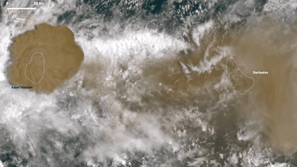
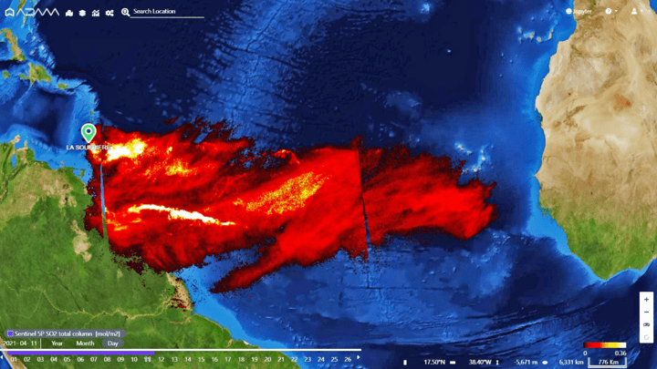
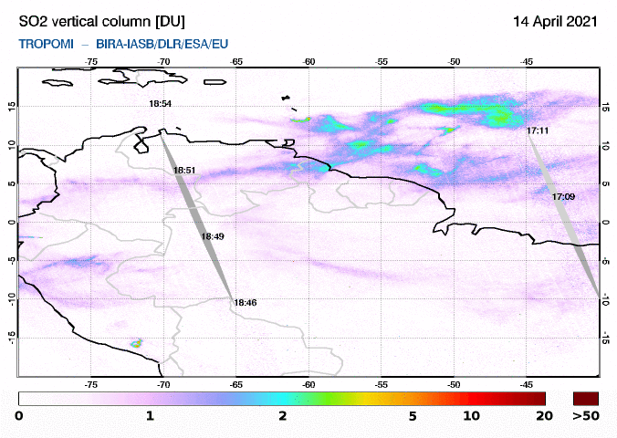
The series of the massive eruptions continue at high levels and are characterized by impressive ash clouds that extended over the Atlantic Ocean advancing the Iberian Peninsula! Satellite-based measurements of SO2 concentrations in the atmosphere show the huge SO2 plumes ejected by Soufrière St. Vincent volcano.
A spectacular dense and dark ash plume reached up to 40,000 ft (12,000 m) altitude that drifted towards the Barbados and further spread about 3,000 km to the E-NE of the volcano.
The warning bulletin of the National Emergency Management Organization (NEMO) urge the residents with respiratory problems to take necessary precautions to remain safe and healthy.
Extending ash cloud over the Atlantic Ocean continues to advance the Iberian Peninsula (source: @m_parrington/twitter)
@CopernicusECMWF Atmosphere Monitoring Service @ECMWF total column SO2 forecast initialized 10 April 12 UTC with assimilated #Sentinel5P obs showing #LaSoufriere plume transport across Atlantic (assuming 500hPa injection height). Visualized by @Windycom https://t.co/WfAgw3vqA8 https://t.co/WvdpDM8U96 pic.twitter.com/34k0lAREux
— Mark Parrington (@m_parrington) April 10, 2021
Huge eruption column visible from satellite (source: @EdPiotrowski/twitter)
Another huge eruption of the #LaSoufriere #volcano this morning. You can see the massive plume of ash and the shock wave emanating from the crater. Incredible! Imagery via #GOES16 pic.twitter.com/Z63PnR2Oi6
— Ed Piotrowski (@EdPiotrowski) April 11, 2021
- All news about: Soufrière St. Vincent volcano
- Information about: Soufrière St. Vincent volcano
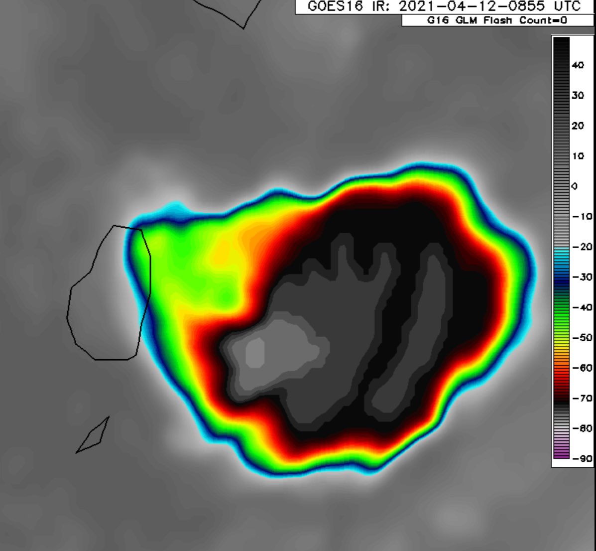
Soufrière St. Vincent volcano (St. Vincent Island, West Indies): second strong explosion in the afternoon
Volcanic Ash Advisory Center Washington reports an ash plume reaching 20,000 ft (7 km) altitude and moving SE. Images taken from the island confirm a tall ash column rising at least 4 km according to estimates from the volcano observatory.
- All news about: Soufrière St. Vincent volcano
- Information about: Soufrière St. Vincent volcano
Soufrière St. Vincent volcano (St. Vincent Island, West Indies): massive eruption sends ash to 20,000 ft
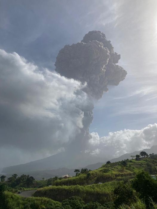
The Belmont volcano observatory indicated the height of the ash plume as high as 8 km (24,000 ft), while the Volcanic Ash Advisory Center of Washington issued alerts of ash to 20,000 ft. The plume drifted east from the island.
Ash fall occurred at the Argyle International Airport and all persons in the red hazard zone, which comprises the northern third of the island, were asked to evacuate immediately. In Georgetown alone, 1,700 people needed to leave their homes.
Video of the eruption:
Change in eruptive behavior
This marks a change in the eruptive style of the young lava dome, from growing rather calmly by effusion of viscous lava towards a much more dangerous mix of effusive and explosive eruptions.
Explosive activity so far had only been minor only, even though videos and images taken the day before (attached) show an increase in degassing, moderate ash venting and glowing rockfalls from the dome, suggesting that something was changing. In any case, the interesting question is what caused this apparent relatively sudden (if not brutal) change. It is not easy to answer this without closer investigation of the eruption products and other parameters only scientists on location have access to, but could help reveal the cause of today's explosion.
One obvious possible reason could be the arrival of more gas-rich magma, which should reflect in a different composition of the eruptive products. Or was it simply that gas-rich parts of the dome's interior, or even trapped pockets of gas had slowly grown beyond a threshold, literally blowing off the cork today?
Certainly, the fact that volume of the accumulated lava in the dome has continued to grow facilitates the process of trapping pockets of gas or gas-charged hot rocks inside. In fact, both explanations can be at work, but we can so far only speculate on this.
It also follows a pattern frequently observed at dome-building volcanic eruptions, such as at Sinabung since 2013, or as a geographically very close example, Soufrière Hills on Montserrat during 1995-2000, but also many others. In the first stage, the eruption is mainly effusive and often brusquely turns to a mix of effusive and explosive activity.
- All news about: Soufrière St. Vincent volcano
- Information about: Soufrière St. Vincent volcano
Soufrière St. Vincent volcano (West Indies, St. Vincent): effusive eruption continues with series of seismic swarm
On 5 April at 06:38 local time a swarm of small volcano-tectonic earthquakes began to occur as the West Indies Seismic Research Centre's (UWI-SRC) seismic station recorded. The quakes increased gradually until about 08:30 local time as continued at steady rate after. The earthquakes were located beneath the volcano's summit at 6 km depth. The largest event reached the magnitude of 3.5 that was felt by residents living close to the volcano. The swarm is related with an elevated seismic activity at the volcano occurred during 23-26 March as a period of volcano-tectonic earthquakes was detected.
The Volcano Alert Level remains at Orange.
Source: University of the West Indies Seismic Research Centre volcano activity update 7 April 2021
- All news about: Soufrière St. Vincent volcano
- Information about: Soufrière St. Vincent volcano
Soufrière St Vincent volcano (West Indies): lava dome continues to grow slowly
Gas-and-steam continued to rise from the top of the dome as well as along the contact between the old and new domes.
As of 19 March the dome was 105 m tall, 912 m long, 243 m wide, and had an estimated volume of 13.13 million cubic meters. The Alert Level remained at Orange (the second highest level on a four-color scale).
- All news about: Soufrière St. Vincent volcano
- Information about: Soufrière St. Vincent volcano
Soufrière St. Vincent volcano (West Indies, St. Vincent): twice length and volume of new lava dome since last update
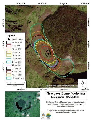
On 19 March the University of the West Indies Seismic Research Centre (UWI-SRC) monitored the volcano by drone to detect of physical changes of the new lava dome.
The central active vent continues to feed the growing lava dome in north-west and south-east direction. The extruded lava dome is currently about 105 m tall, 243 m wide and 921 long (511 m on 4 Feb) with a volume of 13.13 million cubic meters (5.93 million cubic meters on 4 Feb). Its length and volume is almost twice since the last update on 4 February.
The observations confirmed ongoing sulfur dioxide (SO2) emissions concentrated on the top of the new dome as well as at the contact with the 1979 lava dome.
Source: University of the West Indies Seismic Research Centre volcano activity update 22 March 2021
Latest drone video taken of the new dome at La Soufrière, SVG on March 19th, 2021. Its approximate dimensions are 921m in length x 243m width and 105m in height. The volume of material ejected is now estimated to be 13.13 million m3. The Centre and NEMO SVG continues to monitor. pic.twitter.com/BkGJ1olq96
— UWISeismic Research (@uwiseismic) March 21, 2021
- All news about: Soufrière St. Vincent volcano
- Information about: Soufrière St. Vincent volcano
West Indies, St. Vincent, 13.33°N / -61.18°W
Current status: normal or dormant (1 out of 5) Soufrière St. Vincent volcano eruptions:
2020-21, 1979, 1902-03, 1880?, 1814, 1812, 1784, 1718 (historical eruptions observed)
Typical eruption style
effusive (lava dome extrusion) and explosive
More on VolcanoDiscovery

A new fissure eruption started on Iceland's Reykjanes peninsula in Mar 2021. Follow the latest news and updates on this remarkable event!

Visiting an erupting volcano is an unforgettable experience. If you're particularly looking to see "Red Hot Lava", these are among the best places to go to.

This 17-days adventurous expedition is one of our most exciting volcano tours! Visit Halmahera, North Sulawesi and the Sangihe Islands with some of Indonesia's most active volcanoes, including Dukono, Ibu, Lokon, Soputan and Karangetang.

One of the largest and most active volcanoes in East Java, rarely-visited and relatively unknown Raung became (in)famous during its recent eruption in 2015 when its frequent ash plumes forced the repeated closure of Bali's airport.
Support us - Help us upgrade our services!
We truly love working to bring you the latest volcano and earthquake data from around the world. Maintaining our website and our free apps does require, however, considerable time and resources.We need financing to increase hard- and software capacity as well as support our editor team. We're aiming to achieve uninterrupted service wherever an earthquake or volcano eruption unfolds, and your donations can make it happen! Every donation will be highly appreciated. If you find the information useful and would like to support our team in integrating further features, write great content, and in upgrading our soft- and hardware, please make a donation (PayPal or Online credit card payment).
Planned features:
- Improved multilanguage support
- Tsunami alerts
- Faster responsiveness
- Design upgrade
- Detailed quake stats
- Additional seismic data sources
If you like to support Ukraine from abroad:
Ukrainians recommend the Come Back Alive charity. For other options, see StandWithUkraine.


