

The Soos Creek Trail is a nearly 6-mile (one-way) trail that follows the eponymous Big Soos Creek in the East Hill area of Kent. It starts at a trailhead just off SE 192nd St and proceeds in a generally southern direction to a trailhead on 148th Ave SE near Lake Meridian. The entire trail is paved, but for most of it, there is also a parallel soft surface path for those who prefer the dirt or horses. Besides horses and hikers, the trail is also open to cyclists, rollerblades and most other non-motorized travel. Dogs are also welcome (on leash) and are a very common sight.
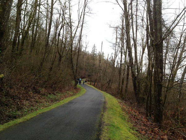
The trail travels through wetlands in several locations as well as through forests in places where the trail is further from the creek. Depending on the time of year, there can be fall foliage to see, birds to watch and even berries to snack on. On clear days, you can see Mount Rainier poking above the trees to the south.
As is typical for trails running in a more suburban environment, there are numerous places to access the trail along the length, mostly at major crossroads. At the north end, the trail starts near the intersection of SE 192nd St and 124th Ave SE with an established trailhead and about 15 parking spots, and usually a port-a-potty. Following the trail south from here, the trail is on an elevated concrete causeway a foot or two above marshlands, with high-voltage powerlines running overhead. The trail here is flat for about a half mile, when it climbs up away from the creek and powerlines, and enters the woods. There is neighborhood access from SE 201st Pl here, but no parking. At about 1.1 miles from the start, the trail crosses SE Lake Youngs Way with a dedicated traffic signal.
The trail meanders a bit more through trees until arriving at Gary Grant Park at SE 208th St about 1.4 miles from the start. Gary Grant Park has some small fields, some playground equipment for kids, permanent restrooms and a parking area. Despite having about 40 parking spots, on a summer day, this lot fills up quickly.
Continuing to follow the trail south, cross SE 208th St. There is a crosswalk here and flashing yellow lights, but exercise caution, as traffic can be quick. From here, the trail continues with patches or marshland and occasional tree cover for another half mile (1.9 miles from the start) to the next road crossing: SE 216th St. Turning left here (east) will get you a connection to the Lake Youngs Trail. The connector to the Lake Youngs Trail is the street itself. No sidewalks or paths, for the first half, but the street is a dead-end street with just a handful of houses so traffic is not a concern. It is also a narrow street, so there are no opportunities for parking here. Keep going on the Soos Creek Trail, and in another half mile (2.4 miles from the start) you’ll get to SE 224th St.
If you aren’t paying attention, you may think the trail just ends at 224th. Instead, just turn right (west) and follow 224th for about 400 feet, and the trail continues on the south side of the street. Again, no sidewalks or shoulders, but the street is a dead end with only one house on it. Proceeding down the trail, the overhead powerlines have returned, and the trail follows pretty much right under them for 0.6 miles. So if you are doing this on a hot summer day, you'll be out of luck for shade for a little bit. It ducks back into the trees afterward though, and stays pretty shady to the next major intersection at 148th Ave SE. Cross 148th carefully as there are no lights here. Also while you might think you could squeeze in a couple of cars to park here, it is signed no parking.
Immediately after crossing 148th, you’ll pass over a bridge that crosses "Big Soos Creek," but don’t blink. Someone clearly used a lot of artistic license in naming the creek. In 0.3 miles (4.2 miles from the start) you cross SE 240th Ave SE. The trail crosses at a bit of a blind corner, and cars can come up quick — however, there are dedicated traffic signals here, so make sure to hit the button and use them. No parking here either.
In 0.4 miles, you get a choice as the trail forks. Turn right and in 600 feet, you’ll reach a trailhead that’s on 148th Ave SE (aka the northern 148th Ave SE trailhead, there’s another one further on), with about 50 parking spots, and besides a port-a-potty, that’s about it. If you go to the left the trail continues towards SE 256th St. It's been reported that in the winter, after the leaves have fallen, you can see a heron rookery in the wetlands here.
At nearly exactly 5 miles from the start, you cross SE 256th St. It’s another moderately busy road, with just a crosswalk and no lights, so make sure to watch any small ones who are with you. This is also where the powerlines cross over the trail for the last time, not to be seen again. The trail then heads up from the creek into the trees for another 0.6 miles to end at another trailhead on 148th Ave SE (a.k.a. the southern 148th Ave SE trailhead). You know you’re getting close when you cross SE 264th St, which is little more than a gravel driveway. The trailhead has about 25 parking spots, and is equipped with a port-a-potty as well.
Were you hoping to actually finish at Lake Meridian? Maybe go for a dip? Well if you backtrack about 100 yards from the trailhead, you’ll find a dirt trail taking off to the left. Follow that dirt trail for about a quarter of a mile where it ends at 152nd Way SE. On the opposite side of the street is Lake Meridian Park. But cross carefully, there isn’t a crosswalk here.
 Trailhead


