Russian Federation
Russian Federation: Russia, the world’s largest country. russian federation 14 countries: Azerbaijan, Belarus, China, Estonia, Finland, Georgia, Kazakhstan, North Korea, Latvia, Lithuania, Mongolia, Norway, Poland, and Ukraine. It shares the maritime borders with Japan, Sweden, Turkey and the United States.
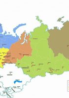
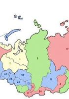
Political Map of the Russian Federation
it is the largest country in the world, covering more than 11% of Earth’s land areas.
With an area of 17,098,242 km² the country is somewhat larger than twice the size of the contiguous United States, it is still the largest country in the world, covering more than 11% of Earth’s inhabited areas.
Geography of Russia
But vast regions of the country were uninhabited or uninhabitable. Russia is a country with a very low population density (8.5 people/km², compared Germany 226 people/km², USA about 33 people/km²). But still, Russia has a population of 144 million people (in 2015). Moscow is the capital and core of political power and the center of culture, and trade, St. Petersburg is the second largest city.