
An informed but personal interpretation of travel access across the Sahara, believed to be correct at the date of updating. For Saharan travel in a specific country click ‘Country Info’ above or visit the forum.
Updated March 2024

For centuries crossing the Sahara has been limited to a handful of routes. In the old days camel caravans followed a string of reliable wells, while circumventing difficult terrain like mountain ranges or sand seas (left). Prevailing routes also shifted according to political alliances and the activities of bandits.
It’s not an exaggeration to say the situation today is broadly similar. The Sahara remains by and large, a huge unpoliced wilderness where the risks to the traveller are not to be underestimated. Following the desert tourist-kidnapping era, foreign overland travellers and tourists are now rare outside of Morocco.

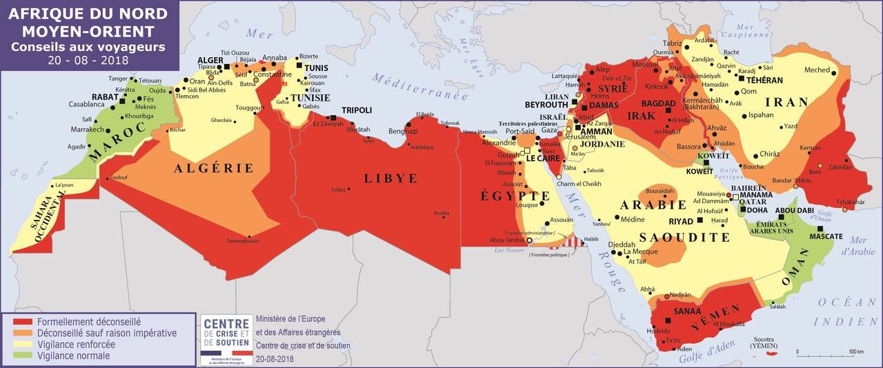
The map above shows the current Atlantic Route, the newly open-to-all Tindouf Route and two Nile Routes in green. These border crossings are the only way motor tourists can cross the Sahara. Formerly safe tourist routes are in red, none have been used for at least a decade. Right now there are four desert border crossings on these routes:
• Morocco–Mauritania Guergarat – Nouadhibou on the Atlantic Route
• Algeria–Mauritania Tindouf – Bir Mogrein – Zouerat
• Egypt–Sudan Argeen (Nile west)
• Egypt–Sudan Wadi Halfa (Nile east)

Government Travel Advisories
UK FCO • US DoS • French MAE
![FCO 329 - Egypt Travel Advice [WEB] Ed16](https://saharaoverland.files.wordpress.com/2013/09/fcoegypt.jpg)

Click links above for official government travel advice, but note some maps and advice exaggerate limitations and risks. For example, the French MAE map (below) correctly suggests access between Moroccan Western Sahara and Mauritania. At the time of this update, the British FCO version still does not. Then again, the last version of the French MAE map below exaggerates the lack of access in Algeria, while the current British FCO map could not be more different. Remember, these are travel advisories, not rules.
Nile Route: Egypt – Sudan
2024 and the current conflict in Sudan mean this route is probably closed or unsafe
In the 1970s, crossing the Nubian desert from Egypt right through Sudan to Uganda was the main route to East Africa until the Sudanese civil war put an end to that. A war now rumbles along in South Sudan which separated from Sudan in 2011 and, at the date of this update, it seems civil war in Ethiopia has blocked the route to East Africa. See here.
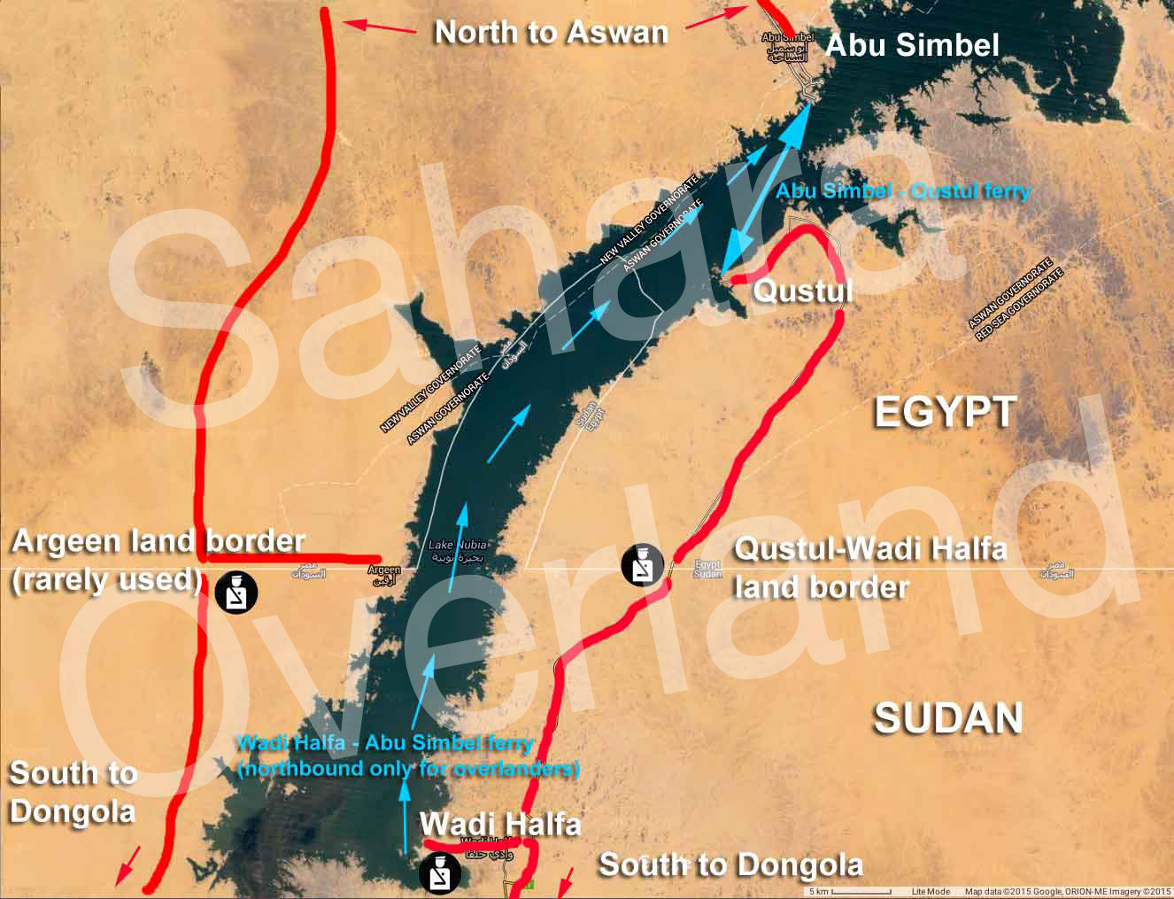
In 2014 a land border finally opened between Egypt and Sudan, though it still requires a short ferry crossing between Abu Simbel and Qustul port (see map above) on the lake’s east shore. Reports from 2018 mention the ferry still runs the full length of Lake Nasser from Wadi Halfa to Aswan but maybe only for passengers and trucks.
Private cars and buses using Argeen or Qustul. In 2017 Argeen was used without the former extortionate fees and so as predicted, this may finally be an all-land crossing between Sudan and Egypt, though one gets the feeling the Wadi Halfa crossing prevails. Report and costs here (got to latest post).
With the current situation in Syria, Egypt is no longer accessible via Turkey, far less via a transit of Libya from Tunisia. The status of Ethiopia in 2022 also blocked the East Africa overland route, though this may have eased. The current solution is a ferry to Israel then Jordan and ferry to Nuweiba, Sinai (Egypt). The ability to do so comes and goes: more here (go to latest post).
Atlantic Route: Morocco – Mauritania
When Algeria initially closed to tourism in the 1990s, the flow of trans-Saharan traffic, both commercial and touristic, shifted west via Morocco and Western Sahara to Mauritania. This is now a sealed road across the desert, barring a few kilometres of piste through No Man’s Land (technically, Polisario territory, not NML). I rode nearly all of it in 2020 and unless you slow down in Morocco, or head inland once in Mauritania, the Atlantic Route can be an unsatisfactory run if you’re looking to experience the real Sahara. Fuel and lodgings are no more than 250–300-km apart.


Note that despite what many maps show, ‘Western Sahara‘ is not a country but a name applied to the former colony of Spanish Sahara, occupied since the 1980s by Morocco to the west and the Algerian-supported SADR (‘Polisario’) inland. Between the two Morocco built a 1500-km long defensive Berm or sand wall.
In 2009 there was a spate of kidnappings in Mauritania. All were released and the road from Nouadhibou to Nouakchott is now well patrolled with checkpoints and is as safe as it ever was. But further south the Route d’Espoir running east from Nema may be less safe.
The Tindouf Route: Algeria – Mauritania

During the French colonial era this was the main trans-Sahara route linking Algiers or Oran with St Louis or Dakar in Senegal. It dodged Spanish Sahara by staying on French West African territory.
It closed in 1963 by which time Algeria and Mauritania were independent. Up till then, today’s Atlantic Route was in Spanish-controlled territory (see map left). This 1965 book dramatically describes the inland transit in 1959.
Following the announcement in 2018 of the re-opening of this 900k off-road route between Tindouf and Zouerat, by the winter of 2019 a couple of southbound tourists had crossed the reopened border, with the last known crossing in February 2022. The honeymoon briefly ended for tourists and groups have had to turn back; only freight was permitted. In 2023 Algeria and Mauritania agreed on a plan to make this a new trans Sahara route between Tindouf and Zouerate, and in February 2024 it was announced with much fanfare that the route was now open to non-freight traffic which may include foreign tourists. A day or so later a Swiss couple crossed from RIM in Algeria (have failed in the other direction the previous year).


Because of Algerian visa and escort issues, it may be easier in a southerly direction, so it’s important to state on your Algerian visa application (in your home country) that you’re exiting via Tindouf. Then your agency’s previously submitted itinerary will have been approved by the Ministry of Foreign Affairs (or not) and will be linked to your application. Or it may have just got a whole lot simpler and be like any other border. Southbound is untested, as yet


It’s about 960km from Tindouf in western Algeria to Zouerat in RIM where the road network resumes. Expect to have to join a military escort at Abadla (700km east of Tindouf) near Bechar (several have dodged this). Once out of Tindouf buy your €55 RIM visa at ‘Hassi Abdallah 75‘, just below the cut line 75km from Tindouf (left; no money changing). With your Mauritanian authorisation, your vehicle is written into your passport alongside the visa and they issue a free vehicle importation permit (TVIP).

From Hassi 75 it’s 885-km of piste to Zouerat. In December 2019 a Norwegian tourist who cut across the PFZ had quite a lot of bother from military checkpoints, but got to Bir Mogrein eventually.
In November 2021 three Algerian trucks were bombed and drivers killed near Bir Lahlou, north of Ain Ben Tili in the northern PFZ (Polisario Free Zone). Algeria blamed Moroccan drones. Algerian truckers were bombed again in April 2022 near Ain Ben Tili and in January 2024 south of Smara (miles away). One presumes Morocco is careful to bomb Algerian truckers when only when they cut across the PFZ between Algeria and Mauritania, and where an outcry would be minimal.
Tourists are advised not to cut across the PFZ as most locals may do, but to work their way south, then turn west at the ‘corner’ towards the fort at Ain Ben Tili (above left; water) – a sandy region with no defined tracks. With other traffic now diverting this way following the bombings, you may no longer be alone on this 310km stage from Tindouf. You will need a 550km fuel range to reach Bir Mogrein, followed by another 410km to Zouerat.

At Ain Ben Tili (ABT; no fuel officially) you rejoin what was the ‘main route’ where the PFZ shortcut came in from the north. There are confusing cross tracks to Bir Mogrein (240km from ABT; fuel, hotel, resto, money change). On the way you’ll pass only nomad tents, some selling fuel.
From Bir Mogrein the southbound piste 410km to Zouerat (fuel, hotels, restos, money change, train to NDB) is well-defined. And from Zouerat you’re on the Mauritanian road network. All distances estimates from online maps. For track-and-tree level aerial imagery, Bing in much better than Google in this part of the Sahara.
Trans-Sahara Highway: Algeria – Niger


The Trans Sahara Highway (‘TSH’) is now sealed from Algiers to the Niger border just south of In Guezzam. From there it’s 15 sandy km to the Niger border post at Assamaka from where it’s now less than 100km to where of tarmac leads to Arlit, 250km from Assamaka.
In February 2021 Algeria boldly announced that this final section would be completed by the summer. Once the section below is sealed the TSH will be all tarmac

No tourist has crossed this way since before the Libyan revolution of 2011 and escorts were required in Algeria when it was last done, plus a military escort (convoys) in the northeast of Niger. It’s said that army escorted commercial convoys leave Tam for Agadez every 15 days, swapping at In Guezzam or Assamaka for a Niger army escort to Arlit and Agadez. I’ve not heard of any tourists being able to join this convoy.
The isolated border post of Assamaka has been attacked several times, most recently in June 2021 and today Point Zero (below) has become a place where 1000s of northbound migrants are regularly expelled from Algeria and left in the desert to walk back to Assamaka.
Tanezrouft Route: Algeria – Mali
Although it was never that popular, following the 1990s the Algerian stage of the Tanezrouft Route south of Reggane (and west of the TSH) got closed to tourists, and even trying to get to Bordj Moktar from Tam became risky or forbidden. The north Malian portion of the Tanezrouft route is a war zone, and for years north Mali was where most hostages ended up in the hands of AQIM or similar groups. For a few years, the French and other forces were engaged in controlling this territory; the left in 2022.
There are other trans-Saharan routes that you might think possible, but for tourists these routes are marginal, dangerous or…
For recent information visit the Sahara Forum or follow the links at the top of this page.


Pingback: Border Crossing Algeria-Mauritania? - Horizons Unlimited - The HUBB
Pingback: 30 days! | Dove Step
Pingback: Horizons Unlimited - The HUBB
Pingback: Horizons Unlimited - The HUBB
Pingback: Maps of the Sahara | Sahara Overland
Pingback: dakar, 18 may | crossroadsofempires
Pingback: Sahara by 2WD Fat Bike | Sahara Overland
Pingback: Book review: The Forgotten Path ~ David Newman | Sahara Overland
Pingback: Y is for: Land Yachting, Sahara, 1967 | Sahara Overland
Pingback: Palin ‘Sahara’ TV reminiscences (BBC) | Sahara Overland
Pingback: ‘S’ is for Shell’s Guide to Sahara Motor Tourism, 1955 | Sahara Overland
Pingback: Sahara Camel Trek • Immidir Plateau | Sahara Overland
Pingback: A is for Atlantic Highway to Mauritania | Sahara Overland
Pingback: Overlanding with Chris Scott, Saharan Expert – News Media
Pingback: Sahara Overland A6: Djanet to Tamanrasset | Sahara Overland
Pingback: Map review: Reise Know-How Morocco 1:1m (2023) | Sahara Overland
Pingback: Ten Positively Insane Facts about the Sahara Desert - Listverse - USMAIL24.COM
Pingback: ▷ Diez datos realmente locos sobre el desierto del Sahara - Listas10Blog