About Us
PAGASA, one of the attached agencies of the Department of Science and Technology (DOST) under its Scientific and Technical Services Institutes, is mandated to “provide protection against natural calamities and utilize scientific knowledge as an effective instrument to insure the safety, well being and economic security of all the people, and for the promotion of national progress.” (Section 2, Statement of Policy, Presidential Decree No. 78; December 1972 as amended by Presidential Decree No. 1149; August 1977)

Mission
Protecting lives and properties through timely, accurate and reliable weather-related information and services.

Vision
Center of excellence for weather related information and services

Values
Integrity, Commitment and Patriotism
Brief history
-
1865
01 January
Philippine Meteorological Service begun under the Observatorio Meteorologico de Manila now Manila Observatory.
-
1879
7 July
The first issuance of typhoon warning crossing Northern Luzon made by the Observatorio and in November of the same year predicted that a strong typhoon will cross over Manila
-
1894
28 April
Under the Royal Decree of Spain, the Manila Observatory was recognized as an official institution under the Jesuits.
-
1901
22 May
By act of the Philippine Commission, the Observatorio was re-organized under the Act No. 131 and was formally named as Weather Bureau under the administrative control of the Department of Interior.
-
1917
The Weather Bureau was placed under Department of Agriculture and Natural Resources when the latter was created.
-
1945
February
The Weather Bureau was blasted to destruction during the battle of Manila. All instruments, records and scientific knowledge accumulated through the years were lost.
24 July
Re-establishment of the Weather Bureau with 7 men constituting its personnel under Mr. Edilberto Parulan as OIC
-
1946
Pursuance to the provision in the Philippine Rehabilitation Act of 1946, a U.S. Weather Mission was sent to Manila to undertake survey of the Bureau’s need. As a result, the Bureau acquired meteorological equipment and technical assistance from the U.S. and pave the way for the establishment of standard weather services patterned after similar institutions in the more technically advanced countries of the world. The Bureau was placed under the Department of Commerce and Industry during this time.
-
1947
The Weather Bureau under the Commonwealth era was transferred to the Department of Agriculture and Commerce and for a brief period under the Department of Public Works and Communications during the Japanese Occupation. Likewise, the Weather Bureau’s Central Office was moved to Marsman Bldg. opposite Pier 15 at the Port Area, while the Forecasting Center was transferred to the MIA Balagbag terminaland it became the Manila Main Meteorological Office or MMMO.
-
1949
New Geophysical Observatory was set-up behind the UP grounds.
-
1950
A teletype service connected the Forecasting Center to Clark Air Force Base, Sangley Point Naval Base and the Bureau of Telecommunications. Exchange of weather reports with foreign countries, aircrafts-in-flight and four aeronautical stations in the country – Laoag, Legaspu, Cebu & Zamboanga began at this year.
-
1954
Astronomical Observatory, UP Diliman Campus. Time signals were transmitted seven times daily by radio.
15 July
Dr. Casimiro del Rosario was appointed Vice Chairman of the NSDB and Mr. Ricardo C. Cruz Chief of the Astronomical Division was appointed OIC.
-
1958
1 August
Dr. Roman L. Kintanar was appointed Director of the Weather Bureau. The youngest ever to hold the post anywhere in the government at the age of 29.
-
1963
The first weather surveillance radar was installed atop the Marsman Building. It was damage by fire and beyond repair in 1978.
-
1968
Computerization of the Weather Bureau and the setting up of a Telemetry System in Marikina River Basin.
-
1969
Weather Bureau Central Office moved once again to its new office at the Asiatrust Bldg, Quezon. Ave. Q.C.
-
1970
Satellite Meteorology came of age in the Philippines when an Automatic Picture Transmission (APT) system was set-up to intercept photo-transmission of the upper atmosphere by satellite. ESCAP/WMO Typhoon Committee Secretariat established its headquarters in the Weather Bureau.
-
1971
Five new radar stations were linked with the Manila radar station to form the Weather Radar Surveillance Network.
-
1972
Establishment of PAGASA under PD 78. PAGASA was transferred from Department of Commerce and Industry to Department of National Defense.
-
1977
02 June
Transfer of the administrative control of the Typhoon Moderation Research and Development Council to PAGASA
-
1984
17 September
PAGASA under EO 984 was transferred from Ministry of National Defense (MND) to National Science & Technology Authority (NSTA)
-
1987
30 January
EO No. 128 mandated the reorganization of NSTA now Department and Technology (DOST) in which PAGASA is one of their line agency
-
1988
01 January
Pursuant to EO 128, the PAGASA was reorganized consisting of (5) major branches and (3) support units.
-
2003
15 January
PAGASA Central Office moved again to a new building and now its permanent headquarters, at the ScienceGarden, Agham Road, Diliman, Quezon City.
-
2008
October
Pursuant to Executive Order 366 series of 2004, the PAGASA was then re-organized under the Rationalization Program in a goal to make the government focus its efforts on vital/core functions and enhance effectiveness and efficiency of public service. PAGASA was re-organized to 5 technical divisions, 5 Regional Services Divisions and 2 support divisions.
Function (Executive Order No. 123; January 1987)
- Maintains a nationwide network pertaining to observation and forecasting of weather and flood and other conditions affecting national safety, welfare and economy;
- Undertake activities relative to observation, collection, assessment and processing of atmospheric and allied data for the benefit of agriculture, commerce and industry;
- Engage in studies of geophysical and astronomical phenomena essential to the safety and welfare of the people;
- Undertake researches on the structure, development and motion of typhoons and formulate measures for their moderation; and
- Maintain effective linkages with scientific organizations here and abroad and promote exchange of scientific information and cooperation among personnel engaged in atmospheric, geophysical, astronomical and space studies.
Product & Services
- 24-Hr Public Weather Forecast issued twice daily and 4-day Extended Weather Outlook for Selected Cities
- 5-day Weather Outlook for Selected Tourist Areas
- Severe Weather Bulletins: 6-hourly Tropical Cyclone Warnings
- Hourly Tropical Cyclone Update
- Shipping forecasts & Tropical Cyclone Warning for Shipping
- Gale Warning
- Storm Surge Warning
- Aviation Meteorological Se4rvices through Access to the World Area Forecast System (WAFS)
- Rainfall Warning system
- Thunderstorm Alert System
- Basin Flood Bulletins for Telemetered Basins and General Flood Advisories for the Non-Telemetered Basins
- Dam Discharge Warning Information during Spilling Operation of the Monitored dams
- Community-Based Flood Early Warning System
- Daily hydrological forecasts during Non-Flood Watch
- Daily Farm Weather Forecast & Advisories
- 10-day Regional Agro-climatic Weather & Advisories
- 10-day Philippine Agro-climatic Review & Outlook
- El Niño/La Niña Watch/Advisory and Information
- Monitoring and Prediction of Seasonal Rainfall
- Climate Projections for Climate Change Adaptation Activities
- Conduct of R&D on Hydrometeorology, Tropical Meteorology, Weather Modification, Meteorological and Hydrological Instruments and on Astronomy, Space Science and applications
- Dispatch Storm Chaser Team to areas threatened and affected by typhoons
- Conduct Calibration, Repairs & Testing (for private and government sectors) of Barometers and other related Equipment
- Assist Researchers from Different Schools, Colleges, Universities and other Agencies
- Public Awareness Campaign on Natural Hazards, specifically Weather, Climate, Typhoons, Floods, Storm Surges and other related hazards
- Conduct of Seminars/Workshops on Meteorological & Hydro-meteorological Hazards
- Conduct of Seminar for Science Teachers on Basic Astronomy
- Public Information Drive for the target areas of monitored Dams
- Conduct of Flood Drills
- Conduct of Annual Media Seminar-Workshops on PAGASA Services
- Conduct of Annual Typhoon and Flood Awareness Week
- Participation in Special Events like Exhibitions, School Celebration and other government and non-government organizations
- Development of PAGASA print materials and non-print materials (flyers, brochures, posters and exhibit display materials)
- Philippine Standard Time (PST)
- Promotion of Astronomy through Stargazing/Telescoping Sessions and Planetarium Shows
- Planetarium tour in selected areas in Luzon
International and Local S&T Linkages
- (WMO) World Meteorological Organization
- (UNESCO) United Nations Educational, Scientific & Cultural Organization
- (FAO) Food and Agriculture Organization
- (IOC) Intergovernmental Oceanographic Commission
- (UNEP) United Nations Environmental Program
- (IPCC) Intergovernmental Panel on Climate Change
- (UNESCAP) United Nations Economic and Social Commission for Asia and the Pacific
- (ACIAR) Australian Centre for International Agricultural Resear
- (UNDP) United Nation Development Program
- (US-AID) US Agency for International Development
- (AUS-AID) Australian Agency for International Development
- (JICA) Japan International Cooperation Agency
- (KOICA) Korean International Cooperation Agency
- (TECO) Taipei Economic and Cultural Office
- (NORAD) Norwegian Agency for Development Cooperation
- (NDRRMC) National Disaster Risk Reduction and Management Council
- (DILG) Department of Interior and Local Government
- (OCD) Office of Civil Defense
- (MMDA) Metro Manila Development Authority
- (ASTI) Advance Science and Technology Institute
- (NRCP) National Research Council of the Philippines
- (PCIEERD) Philippine Council for Industry, energy and Emerging Technology Research and Development
- Philippine Coast Guard
- National Irrigation Administration (NIA)
- National Grid Corporation of the Philippines (NGCP)
- National Power Corporation
- Climate Change Commission
Partnership with Media and Busines/Private Sector
AGHAM Partylist SMART Communications
PDRF (Philippine Disaster Recovery Foundation)
Pscijourn (Philippine Science Journalist Association)
About the Logo
The four circles joined together signify S & T Progress through; Excellence, Relevance, Cooperation and Cost-Effectiveness. The 6 stars are for the major PAGASA Branches and the date 1865 to commemorate the Weather Services as one of the first in Asia. The wind vane and anemometer represent the agency's functions, and the colors (black) represent the Unknown, (white) truth and Enlightenment and (blue) Progress.
Hydrometeorology Division
MISSION
A participatory hydrology service of PAGASA to help prevent/ mitigate the disastrous effects of flooding; and to assist in the development and management of water-related structures nationwide.
VISION
Continually improve flood and warning and hydrometeorological/ hydrological prediction; Extend these activities to other river systems and ungauged areas through the coordinated participation of the local government.
Section Functions
- To formulate, administer and review the implementation of the operational hydrology plans, programs and policies of the agency.
- To coordinate technically the general operations of the HMD Central Office-based units with the PAGASA Regional Services Division (PRSD)/ River Flood Forecasting and Warning Centers, as well as with the concerned offices within and outside the agency involved in the flood disaster risk management.
- To coordinate with the NPC, NIA, DPWH, NDRRMC and others, regarding the inter-agencies Flood Forecasting and Warning Systems for Dam Operation (FFWSDO) and with the MMDA regarding the Metro Manila Effective Flood Control Operation Systems (EFCOS); and
- To maintain local/ international hydro-related linkages/cooperation
- To monitor the meteorological and hydrological conditions of the country's river basins/systems being serviced in collaboration with the PRSDs, for the provision of hydrological/flood information packages;
- To collaborate with: NPC and NIA in the implementation of the hydrological aspect of Flood Forecasting and Warning System for Dam Operation (FFWSDO); MMDA on the Metro Manila EFCOS; and other national institutions involved in flood disaster mitigation and other related activities;
- To improve the methods, procedures and tehcniques in hydrological (flood) forecasting and warning; and
- To conduct public information/education on floods and other related topics in the national level.
- To undertake basic hydromet/hydrologic data acquisition and processing for the provision of hydromet/hydrologic predictions or design storms, hydro forecasting models, flood hazards maps and other applications;
- To improve the methods, procedures and techniques in hydromet/hydrologic applications and in the maintenance of the Division's database management system;
- To monitor the River Flood Forecasting and Warning Center's non-real-time data acquisition and primary processing; and
- To coordinate with the PRSD regarding the outputs of the hydrometeorological station network
- To monitor the overall operation and maintenance of the Division's/ PRSD River Forecast Centers telemetry/telecommunication system networks, telemetering gauging instruments / equipments and other electronic and electro-mechanical facilities, for real-time hydrologica data acquisition.
- To improve the methods and procedures in the operation and maintenance of the telemetry and multiplex telecommunication system.
- To collaborate with NPC and NIA in the implementation of the telecommunication aspect of Flood Forecasting and Warning System for Dam Operations (FFWSDO).
The primary functions of the Pampanga, Agno, Bicol and Cagayan (PABC) River Flood Forecasting Warning Centers are:
- To monitor the meteorological and hydrological conditions of the concerned river basin and the dam operation in coordination with FFWS, for the issuance of various hydrological information packages;
- To conduct river hydrographic survey and primary data processing, and basin post-flood investigation in coordination when needed with HMDAS and FFWS, respectively;
- To maintain the hydrological observation facilities and telemetry system of the basin, including the electro-mechanical and gauging equipment / instruments, in coordination with HMTS;
- To conduct public information drives on floods and other related topics in the local level; ands
- To collaborate/cooperate with local institutions involved in flood disaster mitigation and other related activities.
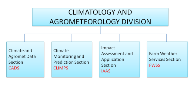
Climatology and Agrometeorology Division
Climate Information, Monitoring and Prediction Services and related activities
The Climatology and Agrometeorology Division (CAD) is responsible for the collection, quality control, processing, storage and retrieval of meteorological, agrometeorological, climatological and allied data and information in usable format; the provision of standard statistical products, customized climatological products and user services specially tailored for policy/decision makers and other users in the various sectors, such as in agriculture, energy and water resources; and, the preparation and issuance of long term climate predictions, seasonal climate outlooks and advisories on extreme climate events such as El Niño and La Niña. It also undertakes specialized climate and climate change studies and researches in support of national development.
Data Management
This involves the operation and maintenance of the PAGASA's Climate Data Bank and Management System for the collection, processing, storage and retrieval of climatological and allied data for research and for general usage. Maintain and update the database of Meteorological, Climatological, Agromet, Marine, Ozone, Solar radiation and allied data and information. To ensure the integrity and reliability of data, the quality control, processing, and archiving of meteorological, climatological and allied data are done in accordance with World Meteorological Organization (WMO) recommended practices and standards.Certified customized information to interested clientele such as those required in litigation proceedings and other purposes, are routinely issued.The CAB also generates and issues meteorological and climatological publications, and other processed information such as standard statistical products, for the consumption of scientists, researchers, professionals, students and other interested parties.
Information And Prediction Services
The CAB vigorously pursues activities to develop and evaluate techniques for the improvement and/or operationalization of medium and long term climate information and prediction services for industry, agriculture and other sectors, including a viable system for packaging and commercialization of information specially tailored to the specific requirements of clients/users.Drought bulletins, intra-seasonal climate predictions, weather-based crop calendars, agrimet bulletins and advisories, and customized climate information are periodically prepared and issued for educational, engineering, commercial, industrial, agricultural and other purposes needed for sustainable development.The CAB also prepares and issues, on a regular basis, climate impact assessments for various sectors such as in energy, land use, building design, tourism, marine and water resources, pollution, and health, among others, as inputs to planning and decision making.
Research And Development
Specialized monitoring stations for research, are operated and maintained by the CAB. These include climate / rain, agro-meteorological, ozone and regional background air pollution monitoring stations.As part of its research and development activities, researches and studies on the application of meteorology and climatology, especially as they relate to agriculture, human health, industry, commerce, and the environment, are undertaken. Studies are also conducted on agriculture- weather relationships, validate or modify available statistical/dynamic models, and develop agroclimatic indices and zoning for the country.The CAB maintains liaison and coordinate with local and international bodies and organizations in the conduct of collaborative researches and studies in climatology, seasonal climate prediction/variability, climate change, agrometeorology and allied fields.It also undertakes the processing, analysis and interpretation of data such as ozone, climate change, rain acidity and chemistry, and conduct relevant studies, as part of its regular functions.
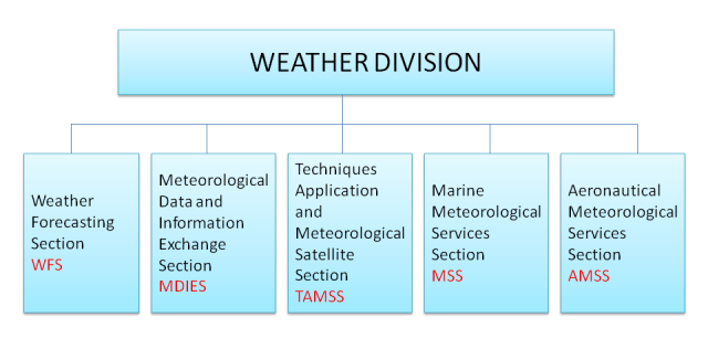
Weather Division
MISSION
Real time collection of high-quality meteorological data for effective use in the provision of weather information, the issuance of timely and accurate forecasts and warnings for the general public, shipping and civil aviation.
VISION
Envisions itself to be of relevant service to society by attaining world-class competence in weather forecasting and warning that will ensure the safety and welfare of communities vulnerable to meteorological hazards and promote the economic well-being of the nation.

FUNCTIONS
Undertakes continuous monitoring, analysis and prediction of atmospheric conditions and issues forecasts daily for the general public, shipping and civil aviation. Issues warnings and bulletins on tropical cyclones and other potential dangerous meteorological conditions for the welfare of society and the country; maintains an efficient meteorological telecommunication system for effective collection/reception of data, local and international exchange of data and warning bulletins, weather forecasts and other relevant information; and conducts operational studies/investigations for the continuing development/improvement of weather analysis and prediction techniques.
Weather Forecasting Section
- Implements plans and programs pertaining to the improvement of the quality of real-time weather analysis and forecasting
- Undertakes routine tri-dimensional atmospheric analysis on a real-time basis using surface and upper-air maps with plotted data from synoptic and upper-air stations, aircraft and ship reports, and meteorological satellite imageries and RADAR data;
- Performs real-time prognostication of the synoptic condition or systems using guidance NWP products and other techniques and issues public weather forecast, and specialized forecast for specific clients;
- Conducts continuous surveillance of severe tropical disturbances and issues warnings and bulletins on tropical cyclones and other severe weather systems that threaten to affect the country; and
- Disseminate forecast and warning bulletins through radio and tv broadcasts, dial-up voice server, electronic fax and email system.
Marine Meteorological Service Section
- Implements plans and programs pertaining to the improvement of the quality of weather and sea condition analysis and wave forecasting;
- Conducts continuous surveillance of weather and sea conditions;
- Performs real-time prognostication of the synoptic condition or systems using guidance NWP products and other techniques and issues shipping forecasts for domestic and international shipping vessels and during tropical cyclone occcurences and other severe weather systems as well as marine gale warning and marine bulletin and other marine related information to appropriate agencies concerned, ship owners and operators, fishermen and coastal raidio staions;
- Disseminate forecast and warning bulletins through radio and tv broadcasts, dial-up voice server, electronic fax and email system.
Techniques Application and Meteorological Satellite Section
- Develops, creates, tests and maintains operational and application programs to automate general weather forecasting procedures and specifications;optimize tropical weather and typhoon prediction models, numerical weather prediction softwares and adapt them for operational use;
- Develop, maintains and updates the Weather Division Homepage;
- Coordinate in the installation of softwares (applications and operating system upgrades) to ensure a smooth running of the Weather Division computer system;
- Handles system administration (including diagnosis and repair of software and hardware problems as they occur) of all computer systems within the Weather Division;
- Undertakes verification and evaluation of numerical weather prediction products being used
- Archives numerical weather prediction products, tropical cyclone information for future research activities; and
- Provides technical assistance to the users within the computer network.
- Conducts routine operation and maintenance of both the polar orbiting satellite tracking, receiving and processing systems and the geosynchronous satellite receiving system to provide continuous real-time weather satellite imagery for weather analysis and forecasting.
- Undertakes activities to generate advanced application products from satellite data for tropical cyclone forecasting, mesoscale convective system analysis, and other useful applications; and
- Performs archiving of satellite data from both system for research purposes and other future uses.
Meteorological Data and Information Exchange Section
- Implements plans and programs pertaining to the development and improvement of the meteorological telecommunication system for efficient reception, dissemination, and local/international exchange of data, forecasts, warning bulletins and other relevant information;
- Performs 24-hour realtime operation of the meteorological telecommunication facility of PAGASA and receives/collects meteorological data and disseminates weather forecasts, weather bulletins and other relevant information/messages; and
- Conducts continuing telecommunication-related activities in relation to the World Meteorological Organization - World Weather Watch Program and operates the message switching system for PAGASA
Aeronautical Meteorological Services Section
- Undertakes continuous monitoring and reporting of weather changes in the aerodrome, issues trend forecast with every regular and special observation reports, and issues warning bulletin for significant meteorological phenomena hazardous to aircrafts approaching and within the aerodrome;
- Conducts routine weather analysis and prognostication for the preparation and issuance of flight documentations for all scheduled international airline flights originating from the Philippines;
- Issues routine terminal and aerodrome forecasts and other aviation-related information and disseminates these through the aeronautical fixed telecommunication network; and
- Conducts briefing and debriefing of pilots and flight dispatchers
Research & Development and Training Division
- Supervises and monitors and planning, coordination and conduct of research and developmental activities in the fields of Hydrometeorology, Agrometeorology, Tropical Meteorology, Meteorological and Hydrological Instrument, Space Science and Astronomy;
- Supervises and monitors the planning, coordination and conduct of technical training in line with the Human Resource Development Plan of PAGASA;
- Directs and supervises the activities of the RDTD through the Chiefs of Sections to ensure its continuous functions;
- Supervises the implementation of Agency policies and programs in RDTD and
- Perform other assignments as directed by higher management.
- Develops and tests new techniques to enhance climatological analysis and prediction particularly the use of numerical weather analyses and prediction products and satellite images;
- Undertakes studies on climate change/variability with the view of predicting such changes and extreme unusual climate events; and
- Undertakes researches pertaining to crop-weather models water balance, radiation, etc.
- Undertakes researches in the atmospheric, hydrologic, agrometeorological and meteorological instruments design including but not limited to the application of remote sensing technique; Conduct flood risk assessment studies;
- Conduct flood risk assessment studies;
- Designs and develops prototypes of meteorological instruments with the maximum use of indigeneous materials and technology;
- Undertakes researches on understanding and predictability of the unusual behavior of tropical cyclones such as sudden change in intensity/structure, and erratic movement in support to the operation needs of tropical cyclone forecasting;
- Undertakes researches on the numerical analysis of typhoons and other related weather systems and on the capability of developing medium range forecasting
- Undertakes studies on the development of an expert system of tropical cyclone and weather forecasting scheme; and
- Undertakes researches on rainfall forecasting utilizing all conventional techniques which include remote sensing.
- Undertakes researches on the application of Numerical Weather Prediction (NWP) in understanding unusual weather pattern and extreme rainfall events;
- Undertakes initiatives in the advancement of numerical modeling on weather; climate and hydrologic forecasting;
- Maintains database of all NWP products generated including related information acquired from known Meteorological Centers;
- Adapts and calibrate atmospheric hydrologic and climate numerical models for operational and research purposes; and
- Ensure the full utilization of the Super Computer system both in research and operation.
- Undertakes studies and investigations of astronomical objects and phenomena;
- Conducts researches in astronomy, space technology and applications;
- Operates and maintains space and astronomical observation. Measurement and/or recording of space objects and phenomena;
- Maintains and disseminates precise Philippine Standard Time (PST);
- Promotes astronomy and space science through the conduct of lectures, seminars, workshops, planetarium shows and stargazing and telescoping sessions; and
- Maintains linkages with local and international space and astronomy organizations/institutions in information and data exchange and related activities
- Formulates and implements plans and programs for the conduct of training activities in the atmospheric, geophysical and space sciences, including the administration of local and foreign training grants;
- Operates and maintains the training facilities of the Agency in support of its human resources development program;
- Operates and maintains library facilities and services for the agency as well as other users; subscribes books, magazines; newspapers, scientific journals and other technical publications in support of the training and research activities of the agency.
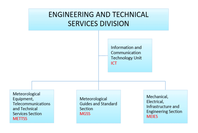
Engineering and Technical Services Division
Office of the Division Chief
- Management, coordination and supervision of activities concerning engineering and technical services for the agency including maintenance of facilities and equipment;
- Direct functions, operations, programs, activities and services of the Division;
- Implements plans and programs for field station infrastructure, facilities and equipment modernization;
- Provides updated standards and guides on meteorological instruments and methods of observation in accordance with established international and/or regional techniques and procedures for meteorological observing services.
Meteorological Equipment, Telecommunications and Technical Services Section (METTSS)
- Undertakes installation, repair and maintenance of the agency’s Weather Surveillance Radars, Upper-Air Sounding equipment, Automatic Weather Station (AWS), Meteorological basic instruments and equipment;
- Provides technical services for the maintenance of the agency’s meteorological telecommunications system (s) and facilities;
- Provides technical assistance to other offices/branches primarily in the installation, repair and maintenance of various telecommunications system and other electronics and communications equipment;
- Undertakes design, development and maintenance of agency’s network infrastructure and other services pertaining to Information Communication Technology (ICT); and
- Formulates updates and implements an effective and efficient agency Information System Strategic Plan (ISSP).
Mechanical, Electrical, Infrastructure and Engineering Section (MEIES)
- Coordinates the planning, management and supervision on matters concerning the maintenance, repair and rehabilitation of the agency’s critical support facilities and equipment, power generators, air-conditioning and refrigeration, water pumps and other electrical and office equipment;
- Fabricate instrument shelters, wind mast and similar support facilities for basic meteorological instruments and related products necessary and/or required for the maintenance of facilities;
- Provides technical services for the repair and/or maintenance of agency’s service vehicles
- Undertakes planning, design and implementation of infrastructure programs and projects of the agency.
Meteorological Guides and Standard Section (MGSS)
- Undertakes quality control of surface synoptic, upper-air, marine, aeronautical agro-meteorological, precipitation and weather radar observation data in accordance with national/regional/international standards for real-time and other uses by the agency’s major units;
- Coordinates and monitors status of station operations and recommends solution and alternative to maintain field station operations;
- Provides updated guidelines, procedures and technical regulations on weather instruments and methods of observation in accordance with the WMO standards.
Organizational Chart