
The Philippine Atmospheric, Geophysical and Astronomical Services Administration (PAGASA), derived from the Tagalog word “pag-asa,” meaning “hope,” stands as the country’s forefront National Meteorological and Hydrological Services (NMHS) agency.
Established on December 8, 1972, through the reorganization of the Weather Bureau, PAGASA holds the vital responsibility of safeguarding the nation against natural calamities.
Its core mission revolves around ensuring the safety, well-being, and economic security of the people, contributing to national progress through the provision of scientific and technological services in meteorology, hydrology, climatology, astronomy, and other geophysical sciences.
As one of the Scientific and Technological Services Institutes under the Department of Science and Technology, PAGASA plays a crucial role in advancing knowledge and resilience in the face of atmospheric and geophysical challenges.
In this article, we will dive into the rich history of PAGASA, explore the diverse range of jobs within the organization, and uncover more about its critical contributions to the nation’s safety and well-being.
Keep reading to gain insights into the dynamic world of PAGASA, and scroll down for a detailed job list within this esteemed agency.
Table of Contents
Job Opportunities:
Explore diverse career prospects within the Philippine Atmospheric, Geophysical and Astronomical Services Administration (PAGASA). Uncover a variety of roles crucial to weather monitoring, disaster preparedness, and scientific advancements.
Embark on your journey to enhance your career by perusing the latest job openings listed below or in collaboration with related government agencies.
Each position presents a unique opportunity to contribute to PAGASA’s vital scientific and technological services in meteorology, hydrology, climatology, astronomy, and other geophysical sciences.
Click on the job title to delve into the details of the role and discover application instructions, bringing you closer to your next career endeavor.
Whether you’re an experienced professional in the field of atmospheric and geophysical sciences seeking a new avenue or someone eager to make a positive impact in the dynamic realm of meteorology, PAGASA offers a platform for professional growth and meaningful contributions.
Seize the opportunity today by exploring the diverse career possibilities with the Philippine Atmospheric, Geophysical and Astronomical Services Administration.
Your future in shaping the scientific and meteorological landscape could be just a click away!
History of PAGASA:
Explore the rich history of the Philippine Atmospheric, Geophysical and Astronomical Services Administration (PAGASA).
From its inception to key milestones, this section delves into the historical evolution of PAGASA, shedding light on its significant contributions to meteorology, geophysics, and astronomy in the Philippines.
Discover the journey of PAGASA in shaping the nation’s understanding of weather and celestial phenomena, marking crucial moments in the development of this essential institution.
Establishment of the Observatorio Meteorológico de Manila (1865-1899)
In 1865, Jesuit scholastic Francisco Colina initiated formal meteorological and astronomical services in the Philippines by founding the Observatorio Meteorológico de Manila.
Located on Padre Faura Street, Manila, Colina, and another Jesuit, Jaime Nonell, systematically observed and recorded weather conditions two to three times a day.
The observatory gained attention after publishing observations in the Diario de Manila, leading businessmen to finance the procurement of a universal meteorograph.
This instrument, invented by Jesuit Fr. Angelo Seechi of the Vatican Observatory, significantly enhanced day and night weather observations.
In 1866, Federico Faura, SJ, became the director of the observatory. The institution’s reputation solidified in 1879 when it issued a warning about a tropical cyclone crossing northern Luzon, leading to effective government precautions.
Over the years, the observatory expanded its services to include seismology, terrestrial magnetism, and timekeeping.
By 1894, it received royal recognition, becoming an official institution under the Jesuit order with support from the Spanish Crown.
American Period: The Weather Bureau (1899-1945)
Following the Spanish–American War, the United States acquired the Philippines under the Treaty of Paris in 1898. In 1901, the Manila Observatory was reorganized into the Weather Bureau under the Department of Interior.
Over the next 45 years, the Weather Bureau gained international acclaim for accurate typhoon forecasts, contributing significantly to meteorology, geomagnetism, and astronomy.
Its first weather map in the Far East, released in 1908 by Fr. Coronas, became crucial for tropical cyclone forecasting.
During World War II, the bureau played a vital role, providing valuable information to the American forces in the liberation of the Philippines from Japanese occupation.
The Battle of Manila in 1945 resulted in the destruction of the Weather Bureau’s offices, marking the end of its operations as part of the Observatorio Meteorológico de Manila.
3. Second World War and Postwar Era (1942-1951)
Under Japanese occupation (1942-1945), the Weather Bureau operated with limited activity, yet its personnel played a crucial role in providing accurate weather information to the combined liberation forces of American and Filipino soldiers.
The war brought a halt to the bureau’s operations when its offices were destroyed during the Battle of Manila in February 1945.
After the war, the Observatorio ceased to function as the Weather Bureau. However, on July 24, 1945, the Weather Bureau was reestablished by seven personnel under Edilberto Parulan’s leadership.
In 1946, a US Weather Bureau mission surveyed the needs of the Weather Bureau under the Tydings War Damage Act.
This survey resulted in acquiring meteorological equipment and technical assistance from the United States, leading to the establishment of standard weather services.
The bureau was transferred to the Department of Commerce and Industry, and its functions were carried out by five divisions.
Postwar Era (1945–1972): Rebirth and Modernization
In 1947, the central office of the Weather Bureau was relocated to the Marsman Building in Manila, and a Forecasting Center was established at the old Balagbag terminal, becoming the Manila Main Meteorological Office (MMMO).
The first post-war geophysical observatory was established in 1949 behind the University of the Philippines campus in Diliman.
The Weather Bureau joined the World Meteorological Organization (WMO) in 1949, and by 1950, a teletype service connected the MMMO to Clark Air Force Base and other locations. Weather reports were exchanged with foreign countries and aeronautical stations.
In 1963, weather surveillance radar was installed atop the Weather Bureau’s Central Office, but it was destroyed by fire in 1978.
By 1965, half of the weather stations across the country were linked through single side-band radio transceivers, forming an independent meteorological communication system.
The Philippines joined the Typhoon Committee in 1968. In 1969, the 5-year “WMO Training and Research Project, Manila” aimed to meet the training needs of meteorological personnel and carry out research.
The project involved technical in-service training and a post-graduate course in meteorology, leading to the acquisition of an IBM 1130 and the initiation of computerization in the bureau.
Satellite meteorology began in the Philippines in 1970 with the establishment of an Automatic Picture Transmission system intercepting photo transmissions of the upper atmosphere by weather satellites.
The same year saw the launch of the “Typhoon Research Project” with financial assistance from the National Science Development Board.
In 1971, the ECAFE/WMO Joint Unit relocated to Manila and became the Typhoon Committee Secretariat.
The Weather Radar Surveillance Network was established by linking five weather surveillance radars.
1970s: From Weather Bureau to PAGASA
In the early 1970s, the Philippines faced a series of devastating typhoons, including super typhoons Sening, Titang, and Yoling, resulting in significant loss of life and extensive damage.
In response to these calamities, in 1972, during the martial law rule of President Ferdinand Marcos, a transformative decision was made.
The Weather Bureau was abolished, and a new agency emerged — the Philippine Atmospheric, Geophysical and Astronomical Services Administration (PAGASA).
This development was in accordance with the Atmospheric, Geophysical and Astronomical Science Act of 1972 (Presidential Decree No. 78, s. 1972) and the Integrated Reorganization Plan (Presidential Decree No. 1, s. 1972) of the Philippine government.
PAGASA was placed under the authority of the Department of National Defense (DND).
Simultaneously, through Executive Order No. 387, s. 1972, President Marcos established the Presidential Committee on Typhoon Moderation.
This committee was tasked with coordinating, planning, and implementing programs aimed at mitigating the severe effects of weather.
Additionally, the Typhoon Moderation and Flood Control Research and Development Council were created to facilitate research and the application of modern scientific methods to moderate typhoons and minimize damage.
Cloud Seeding and Weather Modification Experiments (WEMEX)
In the aftermath of the destructive 1973 typhoon season, the Typhoon Moderation Program began exploring the Cloud Seeding Program as a means of minimizing the dangers of typhoons.
PAGASA director Roman Kintanar led efforts to weaken typhoons by ‘seeding’ them with elements, notably silver iodide.
This process aimed to increase the width of the typhoon’s eye, subsequently enlarging the diameter and reducing rainfall intensity.
This concept was inspired by previous endeavors like the U.S.’s Operation Popeye in 1967 and Project Stormfury in the early 1960s.
Kintanar detailed Weather Modification Experiments (WEMEX), including WEMEX I initiated over Central Visayas in 1975 and WEMEX II over Central Luzon the following year.
While the results were inconclusive, the data collected proved valuable for meteorologists in future tracking of weather patterns and typhoon forecasts.
Structure and Expansion of PAGASA
Initially comprising four organizational units, PAGASA undertook crucial roles in meteorology, geophysics, and astronomy.
The National Weather Service focused on forecasting and issuing weather and flood condition warnings. The National Atmospheric, Geophysical, and Astronomical Data Service handled data acquisition, quality control, and processing.
The National Geophysical and Astronomical Service conducted observations of seismological and astronomical phenomena and provided official time.
The National Institute of Atmospheric, Geophysical, and Astronomical Sciences was responsible for training scientists and technical personnel.
In 1977, the Typhoon Moderation Research and Development Office and the National Flood Forecasting Office were placed under PAGASA’s administrative supervision, expanding its capabilities.
Accomplishments and Projects
During the Marcos regime, PAGASA achieved significant milestones. In 1973, the Pampanga River Basin Flood Forecasting and Warning Project, a joint effort with the Ministry of Public Works, Transportation and Communications, was inaugurated.
This project, supported by the Japanese government, involved the installation of automatic stations along the Pampanga River to monitor water levels.
Impressed by the success of this project, President Marcos instructed PAGASA to explore similar systems in the Agno, Bicol, and Cagayan River Basins.
In 1974, the UNESCO-sponsored Regional Seismological Network in Southeast Asia set up an office in the PAGASA Geophysical Observatory, enhancing earthquake monitoring.
In 1977, a strong motion accelerograph network was established in Metro Manila to record earthquake vibrations. The Science Garden Planetarium, equipped with a Minolta planetarium projector, was opened to the public in April 1979.
In 1983, PAGASA initiated the Flood Forecasting and Warning System for Dam Operations, covering various dams with assistance from the Japanese government.
The agency continued to expand its capabilities, with projects such as the Bicol flood forecasting sub-system and the Ground Receiving Station for the Geostationary Meteorological Satellite.
Post-1986: PAGASA Today
Following the restoration of the democratic government after the People Power Revolution in 1986, President Corazon C. Aquino ordered the reorganization of the National Science and Technology Authority and its agencies, including PAGASA.
This reorganization established five major branches and three support divisions, a structure that remained until 2008 when a Rationalization Program was implemented under Executive Order 366, s. 2004.
In 2003, PAGASA transferred its central office to the Science Garden in Diliman, Quezon City. The agency continued its efforts to modernize and enhance its capabilities.
Republic Act No. 10692, the PAGASA Modernization Act of 2015, allocated funds for equipment upgrades, employee salary schemes, and the creation of the PAGASA Data Center.
On August 8, 2019, Republic Act No. 11363, known as the Philippine Space Act, was signed, creating the Philippine Space Agency (PhilSA) to manage the country’s space program. PhilSA took over responsibilities previously handled by PAGASA.
Meteorological Advancements and Climate Resilience:
In response to growing climate challenges, the Philippines has made significant progress in advancing meteorological capabilities.
This article delves into the efforts undertaken by PAGASA (Philippine Atmospheric, Geophysical and Astronomical Services Administration) to strengthen the country’s ability to monitor and respond to extreme weather events.
From sophisticated climate monitoring to innovative solutions, the Philippines is committed to staying at the forefront of meteorological science for effective disaster preparedness and community safety.
Climate Monitoring and Prediction:
PAGASA (Philippine Atmospheric, Geophysical and Astronomical Services Administration) plays a crucial role in monitoring and predicting the climate in the Philippines.
The agency utilizes daily rainfall and temperature data, along with monthly observations of the standard precipitation index, soil moisture, runoff, and vegetation.
Involved in the World Meteorological Organization (WMO) Regional Climate Centres network node for Southeast Asia, PAGASA offers climate predictions, including subseasonal to seasonal forecasting and one-month probabilistic forecasting with a focus on high-impact weather events.
Specialized forecasts are conducted, gathering data on regional rainfall outlooks in critical areas such as dams, watersheds, river basins, and flood-prone zones.
PAGASA issues regular advisories on regional to global climate phenomena, such as El Niño–Southern Oscillation (ENSO) or La Niña, and provides seasonal climate projections for dry spells, droughts, and monsoons (Habagat and Amihan).
PAGASA’s Climatology and Agrometeorology Division offers services for obtaining climate data, including various climatic elements observed following the best practices recommended by the WMO.
Tropical Cyclones:
The Philippines, being prone to tropical cyclones, falls under the Philippine Area of Responsibility (PAR) for tropical cyclone warnings. PAGASA monitors cyclone activity within this area and issues warnings accordingly.
The PAR is defined by specific coordinates, and PAGASA releases tropical cyclone bulletins every three hours for active cyclones affecting the country, six hours before anticipated landfall, and twelve hours when cyclones are not impacting land.
As of March 23, 2022, PAGASA classifies tropical cyclones into five categories based on maximum 10-minute sustained winds:
1. Tropical Depression – 39 to 61 km/h
2. Tropical Storm – 62 to 88 km/h
3. Severe Tropical Storm – 89 to 117 km/h
4. Typhoon – 118 to 184 km/h
5. Super Typhoon – over 185 km/h.
Tornadoes:
Recognizing the need for a tornado warning system, PAGASA implemented such a system after destructive tornadoes hit Central Luzon.
The agency issues warnings as part of its commitment to public safety, particularly in response to the occasional occurrence of tornadoes that can cause significant damage to houses and infrastructure.
The tornado warning system enhances preparedness and response measures in tornado-prone areas.
The combination of these efforts reflects PAGASA’s comprehensive approach to climatology, encompassing monitoring, prediction, specialized
forecasts, and specific warnings for weather-related events such as tropical cyclones and tornadoes.
PAGASA’s involvement in regional and global climate monitoring networks underscores its commitment to staying at the forefront of meteorological science and providing essential information to safeguard the Philippines from the impacts of climate variability and extreme weather events.
Doppler Weather Radar Network:
PAGASA (Philippine Atmospheric, Geophysical and Astronomical Services Administration) has strategically positioned Doppler weather radar stations across the country to monitor typhoons, precipitation levels, and atmospheric conditions in real-time.
As of 2020, the operational radar stations include locations in Luzon (Basco, Aparri, Baguio, Subic, Baler, Tagaytay, Busuanga, Quezon, Daet, Virac), Visayas (Mactan, Iloilo, Alburquerque, Guiuan), and Mindanao (Zamboanga City, Tampakan, Hinatuan).
Expansion Plans:
PAGASA has ambitious plans for expanding its Doppler weather radar network. Currently, three new stations are under consideration in Agno (Pangasinan), Cataingan (Masbate), and Laoang (Northern Samar).
The bureau aims to achieve a total of twenty operational radar stations nationwide by the end of 2020.
Technological Innovations:
To address forecasting inaccuracies and improve data transfer capabilities, PAGASA has adopted modern technologies.
An automated rain gauge, installed in cooperation with Smart Communications, monitors excess rainfall to provide early warnings against flash floods and landslides.
The bureau is also implementing an automated data acquisition system, modeled after Japan Meteorological Agency’s AMeDAS, to streamline data transfer from ground forecasting stations to the main headquarters.
Collaboration and Support:
Collaborating with international partners, PAGASA is set to benefit from modernization programs.
The Japan International Cooperation Agency is supporting initiatives to enhance meteorology, flood forecasting, and tornado warnings.
Additionally, Taiwan has donated fifteen weather stations to the Philippines, fostering collaboration between PAGASA and Taiwan’s Central Weather Bureau to expand the range of weather forecasts.
Innovative Solutions for Natural Disasters:
PAGASA has introduced innovative solutions to mitigate the impact of natural disasters. Landslide Early Warning Sensors (LEWS), developed by the University of the Philippines, aim to reduce casualties by detecting ground movements and triggering immediate evacuation alerts.
The bureau plans to deploy ten LEWS units in landslide-prone areas by 2012.
Automated Weather Stations (AWS):
The adoption of Automated Weather Stations (AWS) further enhances flood alerts.
Designed to monitor rainfall and flood levels, AWS units, controlled by computers, provide timely information for emergency responses.
PAGASA has begun installing AWS units in various locations, with plans for extensive coverage.
Mission:
“Protecting lives and properties through timely, accurate, and reliable weather-related information and services.”
Vision:
“Center of excellence for weather-related information and services.”
Values:
“Integrity, Commitment, and Patriotism”
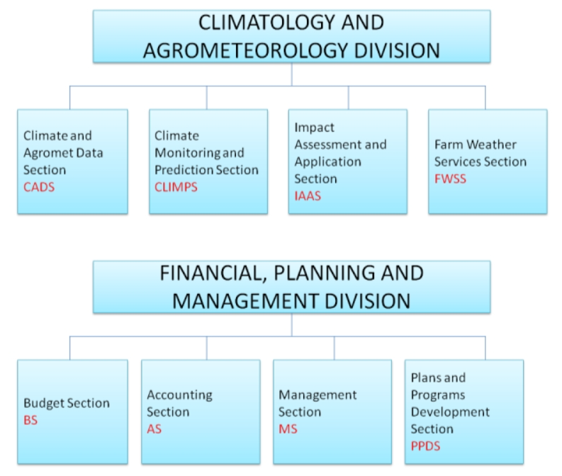
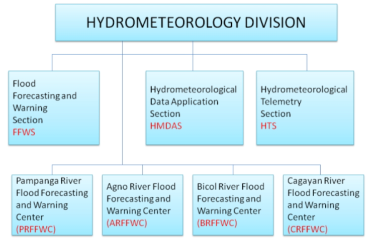
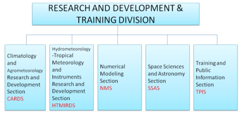
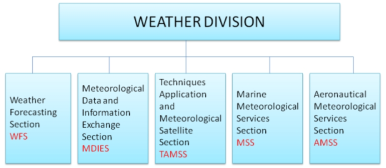
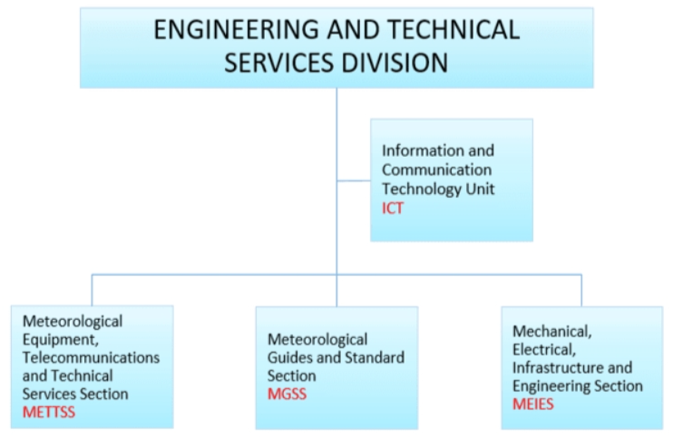
Organizational Structure:
Explore the inner workings of the Philippine Atmospheric, Geophysical and Astronomical Services Administration (PAGASA) through its Organizational Structure.
Gain insights into the hierarchical arrangement, key departments, and the collaborative framework that enables PAGASA to fulfill its crucial role in meteorology, hydrology, climatology, astronomy, and other geophysical sciences.
Dive into the interconnected roles and responsibilities that contribute to PAGASA’s mission of safeguarding lives and ensuring the nation’s resilience against natural calamities.


Contact Details:
If you have any questions or need further assistance, please feel free to reach out to PAGASA using the following contact details:
| Contact Us | Email Address |
| Address | Science Garden Compound, Senator Miriam P. Defensor-Santiago Avenue, Barangay Central, Quezon City, Metro Manila, Philippines 1100 |
| Trunk Line Number | (02) 8284-0800 |
| Connecting all offices at PAGASA Central Office Building, Weather and Flood Forecasting Center, and Climatology and Agrometeorology Division | |
| Local Hotlines | |
| Weather Division | 89271541 |
| 89271335 | |
| 89264258 | |
| 4802 | |
| Hydromet Division | 4826 |
| Climatology and Agrometeorology Division | 4906 |
| Astronomical Unit | 3016 |
| Public Information | 1100 / 1101 |
| FOI Receiving Officers | FOR ADMIN CONCERNS |
| Ms. Rosalie A. Albacite | Administrative Officer V, Records Management Section, AD |
| (02) 8284-0800 local 1356 | |
| Mr. Noli Francis B. Itoralba | Administrative Officer III, Records Management Section, AD |
| (02) 8284-0800 local 1355 | |
| Direct Telephone Line | 3434-2665 |
| FOR DATA CONCERNS | |
| Mr. Christian Mark S. Ison | Weather Specialist I, CAD |
| (02) 8284-0800 local 1121 / 1122 | |
| Ms. Abigail Allen S. Vicente | Weather Observer III, CAD |
| (02) 8284-0800 local 1121 / 1122 |
This table represents the contact information for PAGASA, including the address, trunk line number, local hotlines, and contact details for specific concerns.
If you have any questions or need assistance related to administrative or data concerns, please feel free to contact the respective officers listed.
Conclusion:
In conclusion, the Philippine Atmospheric, Geophysical and Astronomical Services Administration (PAGASA) stands as a vital institution committed to safeguarding lives and ensuring the well-being of the Filipino people.
Through its comprehensive meteorological infrastructure, cutting-edge technologies, and proactive initiatives, PAGASA plays a crucial role in monitoring and predicting climate patterns, tracking tropical cyclones, and providing valuable data for disaster preparedness.
The progress made in Doppler weather radar installations, automated weather stations, and innovative solutions like Landslide Early Warning Sensors reflect PAGASA’s dedication to staying at the forefront of meteorological advancements.”
If you are passionate about contributing to the nation’s resilience against natural calamities, consider exploring career opportunities within PAGASA.
The agency offers a dynamic environment where professionals can make a meaningful impact.
Browse through the latest job openings and take the first step towards a rewarding career in meteorology, hydrology, climatology, astronomy, and other geophysical sciences.
Your skills and dedication can play a crucial role in advancing PAGASA’s mission and ensuring the safety and prosperity of the Philippines.
Disclaimer:
The Philippine Go does not collect fees and is not a hiring agency, nor is it related to any hiring agency for employment abroad.
All information contained here is solely for informational purposes and rightfully belongs to its rightful owner.
Attached in the last section of the content are references for further verification, if needed. Read more
Reference:
1. PAGASA. (n.d.). Philippine Atmospheric, Geophysical and Astronomical Services Administration – Wikipedia. Retrieved from [https://en.wikipedia.org/wiki/PAGASA]
2. PAGASA. (n.d.). About Us. Retrieved from [https://www.pagasa.dost.gov.ph/about-us]
3. PAGASA. (n.d.). Contact Us. Retrieved from [https://www.pagasa.dost.gov.ph/contact-us]