Newton Center
Newton Centre station is a light rail station on the MBTA Green Line D branch, located in the Newton Centre village of Newton, Massachusetts. A former commuter rail station, it was converted for light rail use and reopened on July 4, 1959, along with the rest of the line.Photo: Pi.1415926535, CC BY-SA 3.0.
Photo: Wikimedia, CC BY-SA 2.0.
- Type: Locality
- Description: light rail station in Newton, Massachusetts
- Postal code: 02459
Notable Places in the Area
Newton Centre Branch Library
Library

Photo: Magicpiano, CC BY-SA 4.0.
The Newton Centre Branch Library is a historic library building at 1294 Centre Street in Newton, Massachusetts.
First Baptist Church in Newton
Church

Photo: Tibbetts2c, CC BY 3.0.
The First Baptist Church in Newton was founded in 1788.
Localities in the Area
Newton Centre
Suburb
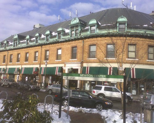
Photo: Mshteinie, CC BY-SA 3.0.
Newton Centre is one of the thirteen villages within the city of Newton in Middlesex County, Massachusetts, United States.
Thompsonville
Suburb

Photo: Faolin42, CC BY-SA 4.0.
Thompsonville is one of the thirteen villages within the city of Newton in Middlesex County, Massachusetts, United States.
Newton Center
- Category: tram stop
- Location: City of Newton, Middlesex, Massachusetts, New England, United States, North America
- View on OpenStreetMap
Latitude
42.33065° or 42° 19' 50" northLongitude
-71.1995° or 71° 11' 58" westElevation
157 feet (48 metres)Open Location Code
87JC8RJ2+75GeoNames ID
4945289Wikidata ID
Q7020162Newton Center Satellite Map
© OpenStreetMap, Mapbox and Maxar
Also Known As
- Chinese: 牛頓中心站
- Chinese: 牛顿中心站
- English: Newton Center station
- English: Newton Centre
- English: Newton Centre station
- French: Newton Centre
- Spanish: Newton Center
- Spanish: Newton Center (Metro de Boston)
- Spanish: Newton Centre (Metro de Boston)
Other Places Named Newton Center
In the Area
Newton Center is situated close to the suburb Newton Highlands and the locality Eliot station.
Localities
- NewtonvilleSuburb
- WabanSuburb, 1½ miles west
- Chestnut HillSuburb, 1½ miles east
- Newton Upper FallsSuburb, 2 miles southwest
- West NewtonSuburb, 2 miles northwest
- Newton CornerSuburb, 2 miles north
Landmarks
Popular Destinations in Massachusetts
Escape to a Random Place
About Mapcarta. Thanks to Mapbox for providing amazing maps. Text is available under the CC BY-SA 4.0 license, excluding photos, directions and the map. Description text is based on the Wikipdia page Newton Center. Photo: Pi.1415926535, CC BY-SA 3.0.