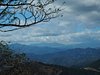
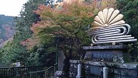
Mt. Oyama
4
About
Suggested duration
More than 3 hours
Suggest edits to improve what we show.
Improve this listingFull view
Revenue impacts the experiences featured on this page, learn more.
Top ways to experience nearby attractions


The area
Best nearby
We rank these restaurants and attractions by balancing reviews from our members with how close they are to this location.
Restaurants
41 within 5 kms

Oyama Sancho Chaya
3
22 m
Saryo Sekison
3
1.2 km$ • Japanese • Cafe
Oyama Afuri Jinja Sanshuden Senshinkaku
8
1.2 kmJapanese • International • Japanese - Other
Sakuraya
8
1.2 kmCafe

Echigoya
4
1.2 kmInternational

Kurumi
4
1.3 km
Kimagure Cafe
7
1.9 kmCafe
Oshokujidokoro Motodaki
6
1.9 kmJapanese

Kankiro
7
1.9 kmJapanese • International • Japanese - Other

Tofu Restaurant Ogawaya
17
2 kmJapanese
Attractions
145 within 10 kms
Fujimidai
6
0.5 kmScenic Walking Areas
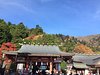
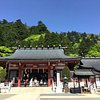
Oyama Afuri Shrine
186
1.2 kmHistoric Sites • Points of Interest & Landmarks
Hanatsuki Rock of Tengu
8
0.8 kmPoints of Interest & Landmarks
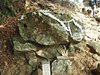
Botan Rock
7
0.9 kmPoints of Interest & Landmarks
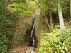
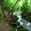
Niju Falls
7
0.9 kmWaterfalls
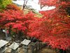
Oyama Temple
65
1.5 kmPoints of Interest & Landmarks
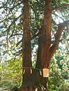
Fufusugi
8
1.1 kmPoints of Interest & Landmarks
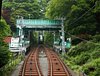
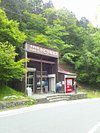
Oyama Cable
130
1.9 kmTrams
Bankoku Chureito
9
1.1 kmMonuments & Statues
Yabitsu Pass
57
1.8 kmHiking Trails
Contribute
Detailed Reviews: Reviews order informed by descriptiveness of user-identified themes such as cleanliness, atmosphere, general tips and location information.
We perform checks on reviews
Tripadvisor’s approach to reviews
Before posting, each Tripadvisor review goes through an automated tracking system, which collects information, answering the following questions: how, what, where and when. If the system detects something that potentially contradicts our community guidelines, the review is not published.
When the system detects a problem, a review may be automatically rejected, sent to the reviewer for validation, or manually reviewed by our team of content specialists, who work 24/7 to maintain the quality of the reviews on our site.
Our team checks each review posted on the site disputed by our community as not meeting our community guidelines.
Learn more about our review moderation.
4.0
131 reviews
Excellent
38
Very good
73
Average
18
Poor
2
Terrible
0

jjunnn
Tokyo, Japan477 contributions
Sep. 2019
For people coming by car, parking space near the information centre is 1,000 yen for a day. From there, you can pick up a map of the area at the Information Centre before heading up. You will have a short 15 mins walk/climb through the shops and restaurants before reaching the cable car station. There are 3 stations where the cable car stops. The first station is at the beginning of the trail, which is the Oyama Cable Car Station (大山ケーブル駅). The second stop is Oyama-dera/Daisenji Station (大山寺駅). The final stop is the Afuri Shrine Station (阿夫利神社駅). Cable car service starts at 9 am every day and ends at 4.30pm on weekdays, and 5 pm on weekends. Do note that there are no services during lunchtime from 12 pm to 1 pm. It operates on a 20 minutes interval. The cable car doesn't bring you up to the summit of the mountain, so from there you will need to take 90 minutes to hike up the trail to reach the summit. Estimated time to descend from summit back to Afuri Shrine Station is about an hour. For hikers who do not wish to take the cable car at all, you can choose between two trails, the men or the women trail. Only women's trail has lights along the path after dark, so do avoid using men's trail if it's getting dark. Depending on an individual's fitness and the trail you take, it's about an hour or less to reach Afuri Shrine Station. From Afuri Shrine Station onwards, there is only one common path up to the summit. Total climbing time from the bottom to the summit will take you about 2 to 2.5 hours (one way). The steps are pretty steep and are potentially slippery on wet days. Do be cautious and wear proper shoes and attire if you plan on climbing. Watch out for leeches, snakes, and bears.
Written 18 September 2019
This review is the subjective opinion of a Tripadvisor member and not of Tripadvisor LLC. Tripadvisor performs checks on reviews.

Pat T
Zama, Japan28 contributions
Mar. 2019 • Solo
After living in the shadow so to speak of Oyama I finally decided this perfect 68F blue sky day was the day.
Take the Odakyu towards Isahara station (someone on here mentioned the wrong station which will really put you in the wrong direction)
Take the north exit out of the train station and follow the signs in English to bus stop four and take bus #10, the bus says to Oyama cable car, it's the last stop on the bus.
First off, if you aren't in shape this trail will be awful, this is your warning.
The trail just climbs for about 3,200 feet non-stop. It's not scenic in any particular way until you get to the top. In fact it's mostly just a ill-maintained washed out trail through what in the US wouldn't be considered a legitimate trail due to it's grade and lack of switchbacks (however my guess is this wasn't considered when this trail was made probably 800 years ago)
If you don't go on a clear day it is essentially a waste of time as the summit will just be misty and cloudy. On a clear day like I had, Fuji was visible, Enoshima island, Tokyo and even Ito down on the Izu peninsula are visible. Overall, if you are hiking this for a good view of Fuji, i wholeheartedly recommend Mt. Takao, less strenuous and much more fun plus a cool town with lots of onsens. And the view of Fuji is just as good.
If you can rent or bring hiking poles i recommend you do so, it will make going down a lot easier on your knees.
Written 20 March 2019
This review is the subjective opinion of a Tripadvisor member and not of Tripadvisor LLC. Tripadvisor performs checks on reviews.

555SD
3 contributions
Jan. 2019 • Family
Drove over to Oyama, just a 22km jaunt for myself, but was a 43min drive. There is some free parking located here (35.4372723, 139.2545558), it’s for a campground, but wide open to whomever, want to say probably enough parking for at least 50 cars.
It’s a 4.3km (+/- depending where you park) hike with an elevation gain of 880m to the 1252m summit. This was my first ever hike, not counting a run (literally) up Fuji from station 5 on the south side to about half way between 7 and 8 once when I was on a drive, people coming down thought I was crazy as I was just in shorts/t-shirt with some basketball shoes and zero gear whatsoever.
Anyways this route is not at all easy, steep steps(natural or manmade) with plenty of open roots and rock. Twisted my ankle about half way up, but kept on going though my pace was quite slowed due to it. Legs completely cramped up with about 150m still to climb, powered on through the pain. We started late as it was an impromptu decision so got underway right before 1PM, got back to the parking area in complete agony at about 5:45. Using our phones as flashlights as it got completely dark once back down into the forest.
If you’re looking for a nice little leg burn, I can easily suggest this hike. Not sure if the normal route from the cable car stations that most take is easier or harder, but if harder, all I can say is damn that. :)
Written 2 January 2019
This review is the subjective opinion of a Tripadvisor member and not of Tripadvisor LLC. Tripadvisor performs checks on reviews.
Joy_Sinha
Kolkata (Calcutta), India2,388 contributions
Oct. 2017 • Friends
Mount Oyama is located at border of Isehara, Atsugi, Hadano in Kanagawa prefecture, peaking at 1252 metres.
Me and my friend hiked to the peak from the Afuri Jinja shrine. The hiking is medium level with some steep areas along the trail. Takes about 1.5 hours from the Afuri Jinja shrine to the peak. Great views of the surrounding mountain areas and the coastline from the top.
To access , get down at the Isehara station of the Odakyu main line between Shinjuku and Odawara. From station, take a local bus to base station of Oyama Cable car. Go up to Afuri Jinja shrine using cable car. The hiking trail begins at an area behind the shrine.
It is suggested to be well equipped in gears during this hiking course.
Written 11 September 2018
This review is the subjective opinion of a Tripadvisor member and not of Tripadvisor LLC. Tripadvisor performs checks on reviews.
i-love-zermatt
Zurich, Switzerland102 contributions
May 2018 • Friends
While staying in Tokyo over a WE, me and my friend decided to do some workout on Sunday. Mount Oyama presents you with a couple of reasonable challenges. The altitude gap between the foot of the mountain and the top is about 900 meters. The trail is pretty steep, especially when you take the “man’s trail” from the bottom of the cable car station to the top of it. The great thing about that first part was that there weren’t that many people on the trail as mostly everyone seemed to ride up with the cable car and then hike up to the top from there. This is then indeed the second challenge: on that Sunday it was extremely crowded, which is OK on the ascent but kind of difficult when you’re on your way down. The weather was fantastic, but the wind was a bit breezy, so I was getting a little cold in my T-Shirt.
We were on a moderately sporty pace and it took us 25 minutes from the bottom to the mid point and then another 55 minutes from there to the top. I realize that this is not everyone’s pace, but it was also not a pace that took us to the limit - so, if you’re doing this for an exercise, you can easily do it in 1 hr 30 up and 1 hour down.
On the descent you want to consider a) that this will demand some leg muscles and if you’re not used to it, you’ll feel it the next day for sure ;-) and b) if the trail isn’t as dry as it was on this Sunday, it can surely be very slippery.
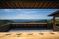
Other than that, you should definite take a lot of pictures as the views are pretty cool.
We were on a moderately sporty pace and it took us 25 minutes from the bottom to the mid point and then another 55 minutes from there to the top. I realize that this is not everyone’s pace, but it was also not a pace that took us to the limit - so, if you’re doing this for an exercise, you can easily do it in 1 hr 30 up and 1 hour down.
On the descent you want to consider a) that this will demand some leg muscles and if you’re not used to it, you’ll feel it the next day for sure ;-) and b) if the trail isn’t as dry as it was on this Sunday, it can surely be very slippery.
Other than that, you should definite take a lot of pictures as the views are pretty cool.
Written 20 May 2018
This review is the subjective opinion of a Tripadvisor member and not of Tripadvisor LLC. Tripadvisor performs checks on reviews.

redeyeblues
Edinburgh, UK1,266 contributions
May 2018 • Solo
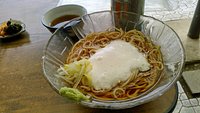
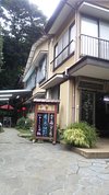
While it may not be so difficult that it's undoable, it is pretty strenous and you need to be reasonably fit. If going continuously uphill on steep uneven stone steps, braches, leaves, and loose rocks is not your idea of fun, this is probably not the place for you. It's not an easy walk in the forest but an actual hike you need sensible shoes to complete. The stretch from the bus stop to the cable car station is lined with shops and restaurants/ryokan, many selling multi-dish tofu sets. From the 1st cable station to the 2nd one, it's not so bad but it starts to get quite steep from there. After the last cable car station past the temple, it becomes even more challenging. Another option is to just take the cable car to the last stop and walk back down (trail down is next to the nice coffee shop) although going back down is not exactly a cakewalk either as it's a bit hard on the knees - beautiful though. The bus back was packed with equally sweaty people even on a weekday.
Written 16 May 2018
This review is the subjective opinion of a Tripadvisor member and not of Tripadvisor LLC. Tripadvisor performs checks on reviews.
Frequentflyer046
Buckinghamshire129 contributions
May 2017 • Solo
Upon visiting Japan in 2016 , I spent a day travelling to Isehara by train (No surprises there) At the above station you can use your Pasmo card to take a bus to the bottom of the mountain . Its worth getting food and water from the station for the days walking , as you can burn a lot of fuel on the walk.
There is an abundance of things to see at various levels of the walk , including A temple . The views are great , the walk is steep in many places , and has large steps , not for the infirm or hard of walking.
There is a cable car that goes up part of the way so that is an alternative.
Along the way there are some street vendors .
Thoroughly enjoyed the walk , it was 30 degrees and 90% humidity , but i would go back and do it again.
Good luck to all who try it.
Written 26 April 2018
This review is the subjective opinion of a Tripadvisor member and not of Tripadvisor LLC. Tripadvisor performs checks on reviews.

Virendra-Yadav_2014
Yokohama, Japan672 contributions
Feb. 2017 • Solo
I have been to this mountain 3 times for a day hike. It is much better to visit this mountain when there is snow at peak. When I visited it in Feb-2017, it was same. Temperature at peak was -5 degree. Very cold, even staying at peak for more then 10 minutes was very difficult if you dont have proper cold wear. But viewing from top of the mountain is superb. You can view Eastern sealine cost easily from Mount Oyama. Also cable car is very much convenient to use. To reach here you need to stop at Aikoishida(Odakyu Line), then take bus(30 min rides, Bus Number 4) till Mount Oyama Cable car station. Either you take cable car or start trekking, its upto you. But I suggest to take cable car till shrine at Mount oyama.
Written 12 March 2017
This review is the subjective opinion of a Tripadvisor member and not of Tripadvisor LLC. Tripadvisor performs checks on reviews.
Recson D
27 contributions
Oct. 2016 • Family
Great day hike for any person who wants to start climbing mountains. The trail is generally easy even for beginners. You just have to watch out for your pace because there are elderly people climbing and man do they climb really fast. So when they pass you, don't get discouraged. Just keep moving and eventually you'll reach the top.
Our itinerary:
9:00AM: arrival at isehara station (rode bus 10)
9:30AM: arrival at bus stop leading to cable car
9:40AM: arrival at cable car station
9:50AM: arrival at grand shrine(jump off point)
10:40AM: arrival at mahidarashi viewpoint
***you'll pass by a waterfall, a shrine, a holy tree along the way. So take plenty of pictures.
At the viewpoint, there are tables available for you to take your break. And the view is spectacular.
10:50AM: start assault to top of oyama
12:30PM: arrival at the summit
12:30- 1:30PM: lunch break
1:30PM: start going down via the other route passing through the mt. fuji viewpoint
3:00PM: arrival at grand shrine(jump off point)
3:40PM: cable car going down
4:00PM: bus to isehara
4:30PM: arrival at isehara station
Things to bring:
-water about 2 liters
-trekking poles
-good hiking shoes(running shoes would do but they have to have traction)
-lots of plastic bags as there are no trash cans at the mountain.
-jacket for rain/umbrella
Notes:
-the road is very slippery during the wet season so always follow the trail.
-no restroom stop between the jump off point and the summit so tinkle first before you start climbing.
-bring a good camera with you.
-buy the wooden souvenir(¥600) and good luck charm(¥200) at the summit to support the locals taking care of the mountain
-support the local business (price is higher than those at the stores below the mountain but thats expected since they bring their ingredients up)
-always say konnichiwa! to the people you meet along the way and be polite and give way to the elderly.
If you have more questions especially foreigners who want to climb, feel free to contact me.
Written 30 September 2016
This review is the subjective opinion of a Tripadvisor member and not of Tripadvisor LLC. Tripadvisor performs checks on reviews.

Venkata Ramana ... S
Machida, Japan45 contributions
May 2016 • Friends
The mountain is 1250Mt and it will test your stamina.I went for trekking 4 hours and returned when it still needed 1.5hrs to reach top. there are two ways to hike 1 otokozaka(mens route) and 2.onnazaka(ladies route). we went UP by ladies route it was steep and was fine.but took Mens route while coming down. as it was completely steps, it was not very easy and have to be very carefull while getting down. for people who dont want to trek, you can go and comeback by cable car.
Written 17 May 2016
This review is the subjective opinion of a Tripadvisor member and not of Tripadvisor LLC. Tripadvisor performs checks on reviews.
Revenue impacts the experiences featured on this page, learn more.


Mt. Oyama (Kanagawa Prefecture): All You Need to Know
Frequently Asked Questions about Mt. Oyama
- Restaurants near Mt. Oyama:
- (0.02 km) Oyama Sancho Chaya
- (1.17 km) Saryo Sekison
- (1.22 km) Oyama Afuri Jinja Sanshuden Senshinkaku
- (1.22 km) Sakuraya
- (1.22 km) Echigoya
- Attractions near Mt. Oyama:
- (0.52 km) Fujimidai
- (1.15 km) Oyama Afuri Shrine
- (0.81 km) Hanatsuki Rock of Tengu
- (0.86 km) Botan Rock
- (0.94 km) Niju Falls