
Plan a route on Google Maps: app, Android, iPhone

Planning a road trip can be both an exciting and stressful venture. With so many factors at play, it's easy to become overwhelmed with which routes to take, how to avoid traffic or tolls, or how to include all points of interest without getting completely lost. Luckily, Google Maps makes it easy to create itineraries, and even customize them on the go. Here's how to get started using Google Maps.
How to plan a route with Google Maps?
Google Maps offers users the ability to visualize their route options between any number of points of interest. Depending on how you'd like to scale your trip, the application allows you to be as specific as (i.e. "taco bar in New York") or as vague (i.e. "Canada") as you like with your searches, and will calculate ideal itineraries from which to choose. You can even use built-in map filters to narrow down your options based on tolls, traffic, or any number of factors. Google Maps is available both online and via smartphone application for Android and iPhone, both formats work the exact same way.
If you already have the address of your destination, you're off to a good start. However, if you're unsure of an address, Google Maps offers you a number of options to help you get to your destination. Here are three ways of calculating your itineraries.
Between two known addresses
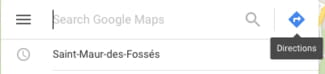
Head to Google Maps and click on the Directions icon located to the right side of the search bar:
A blue options box will appear with a number of icons that represent different modes of transport (car, bus, train, on-foot, bicycle, air):

By default, Maps will automatically calculate the best itinerary for automotive travel, but you can easily switch to another mode of transport by simply clicking on one of the icons.
Enter your starting point into the first field, and the destination into the second. Then click on Calculate. The resulting map will indicate your starting point with a black and white bubble, and your destination with a red bubble. Possible routes are indicated by either a blue line (which indicates the most efficient route), or one of two types of grey lines (which indicate alternate routes):
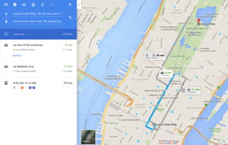
Note that a solid grey line indicates that a route utilizes one mode of transport. If a line also includes dotted grey lines, this indicates that an alternate mode of transportation will also be necessary. In the example above, you'll see that one of the alternate routes includes both automotive transportation as well as walking.
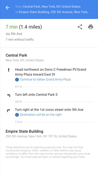
Once you've decided on your preferred route, simply click on the option you'd like to use. Google Maps will provide you with step-by-step instructions on how to reach your destination. These directions will include distance and probable travel time between destinations, as well as turn-by-turn instructions:
With one known address
If you're looking to calculate an itinerary based on your current position, or if you only have one known address, you can use the same tools as above to calculate your itinerary.
Head to Google Maps and either input the desired location into the Search box, or click on the Directions option at the right of the search bar. Type in your destination in the Search field:

Maps will provide you with an overlay of your destination as well as any information given about the location. Click on the Directions icon given in this menu. Maps will then ask you to provide a point of departure. Type in Current Location into the search bar to generate an itinerary based on your current position.
Calculate Google Maps route manually
This third method of using Google Maps is done using your computer mouse. Head to Google Maps, and zoom to find your point of departure or point of arrival. Click on this point.
In the menu that opens, choose From this location or To this location. Then search for your second destination point. Click on it and choose one of the two above commands. Google Maps will generate your ideal itinerary between these two points.
How to plan a route on Google Maps with multiple stops?
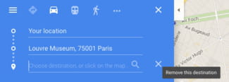
At any point, you may add or delete a destination on your itinerary. To do this, simply right click on the map and choose Add a Destination on the contextual menu. Enter your destination in the field that appears.
You may adjust the desired order of your destinations by simply dragging and dropping the letter options. As you change the order of your options, you will notice that the ideal itinerary (the blue line) given by Google Maps will change according to your plan. The instructions given at the left side of your screen will also change in tandem.
To delete a destination, simply hover over the address in the side bar, and click on the x:
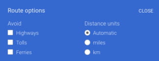
How to add Google Maps filters?
Google Maps offers you several filters to help you modify your routes, including the ability to avoid highways or extra tolls. To apply these filters, simply click on the Options button and select your filters:
You may print your final itinerary by clicking the Print icon shown in the menu. You can choose to print your route with accompanying maps, or as text-only. You can even add notes to your document before printing the final itinerary.
Need more help with Google? Check out our Forum!