


COPYRIGHT 2024 BY CHANNEL 3000. ALL RIGHTS RESERVED. THIS MATERIAL MAY NOT BE PUBLISHED, BROADCAST, REWRITTEN OR REDISTRIBUTED.
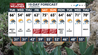
WHAT WE'RE TRACKING:
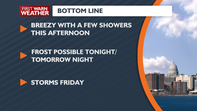
A few afternoon showers today
Frost possible tonight & Wednesday night
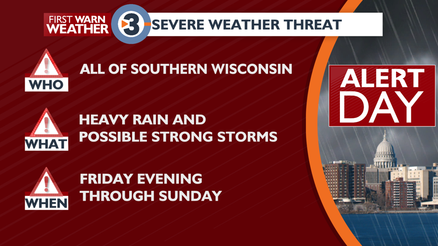
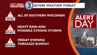
ALERT DAY conditions expected next weekend
PLANNING THE NEXT 24 HOURS: It will be mild today with a chance of showers this afternoon. An isolated thunderstorm is possible. It will be chilly tonight, with frost possible.

EXTENDED FORECAST: There is another frosty night chance Wednesday night, lasting into early Thursday morning. ALERT DAY conditions are possible Friday night, lasting through Sunday. The First Warn Weather Team is tracking periods of thunderstorms with heavy rain, along with the threat for strong storms during this period. The best chance for strong storms will be Saturday afternoon, and then again later Sunday afternoon and evening, especially if clouds can clear some to allow for the atmosphere to get warm and humid enough.


COPYRIGHT 2024 BY CHANNEL 3000. ALL RIGHTS RESERVED. THIS MATERIAL MAY NOT BE PUBLISHED, BROADCAST, REWRITTEN OR REDISTRIBUTED.
Madison, WI
Right Now
- Humidity: 54%
- Feels Like: 58°
- Heat Index: 60°
- Wind: 11 mph
- Wind Chill: 58°
- UV Index: 7 High
- Sunrise: 06:02:34 AM
- Sunset: 07:50:23 PM
- Dew Point: 43°
- Visibility: 10 mi
Today
Variable cloudiness, breezy, and mild with a chance of showers. An isolated thunderstorm is possible in the afternoon. Wind: W/NW 10-20 MPH, with gusts to 30 MPH
Tonight
Becoming partly cloudy, breezy, and cold, with a slight chance of an evening shower. Frost is possible late, especially in open and low-lying areas. Wind: N 8-15 MPH, with gusts to 25 MPH
Tomorrow
Partly cloudy and cool. Wind: E 5-10 MPH
Chance of Rain: 40%
Sunrise: 06:02:34 AM
Sunset: 07:50:23 PM
Humidity: 44%
Wind: W @ 15 mph
UV Index: 7 High
Tuesday Night
Becoming partly cloudy, breezy, and cold, with a slight chance of an evening shower. Frost is possible late, especially in open and low-lying areas. Wind: N 8-15 MPH, with gusts to 25 MPH
Chance of Rain: 10%
Sunrise: 06:01:02 AM
Sunset: 07:51:34 PM
Humidity: 45%
Wind: NE @ 9 mph
UV Index: 7 High
Wednesday Night
Partly cloudy with areas of frost after midnight. Wind: SE 5-10 MPH
Chance of Rain: 10%
Sunrise: 05:59:32 AM
Sunset: 07:52:44 PM
Humidity: 39%
Wind: SE @ 9 mph
UV Index: 7 High
Thursday Night
Mostly cloudy.
Chance of Rain: 70%
Sunrise: 05:58:02 AM
Sunset: 07:53:54 PM
Humidity: 68%
Wind: SE @ 19 mph
UV Index: 3 Moderate
Friday Night
Breezy with scattered showers and thunderstorms.
Chance of Rain: 50%
Sunrise: 05:56:34 AM
Sunset: 07:55:04 PM
Humidity: 82%
Wind: SSW @ 22 mph
UV Index: 6 High
Saturday Night
Chance of showers and t-storms.
Chance of Rain: 60%
Sunrise: 05:55:06 AM
Sunset: 07:56:13 PM
Humidity: 90%
Wind: S @ 17 mph
UV Index: 3 Moderate
Sunday Night
Chance of showers and t-storms.
Chance of Rain: 40%
Sunrise: 05:53:40 AM
Sunset: 07:57:23 PM
Humidity: 75%
Wind: SW @ 18 mph
UV Index: 6 High
Monday Night
Partly cloudy and cooler.
Chance of Rain: 10%
Sunrise: 05:52:15 AM
Sunset: 07:58:32 PM
Humidity: 67%
Wind: W @ 12 mph
UV Index: 7 High
Tuesday Night
A slight chance of a shower or a storm.
Chance of Rain: 40%
Sunrise: 05:50:52 AM
Sunset: 07:59:42 PM
Humidity: 73%
Wind: WSW @ 12 mph
UV Index: 6 High
Wednesday Night
Chance of showers and storms.
Chance of Rain: 50%
Sunrise: 05:49:29 AM
Sunset: 08:00:51 PM
Humidity: 66%
Wind: W @ 12 mph
UV Index: 7 High
Thursday Night
Partly cloudy skies. Low 48F. Winds SW at 5 to 10 mph.