
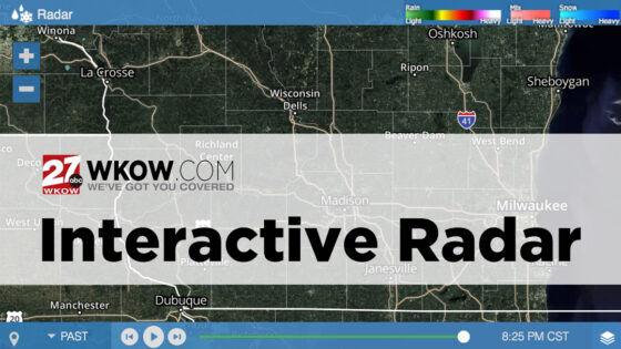
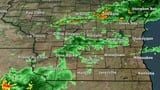
- 27 Storm Track:
- Interactive Radar
- Check the Forecast
- 27 News:
- Download Our Apps
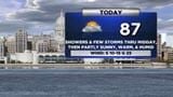
Forecast
Right Now
- Humidity: 38%
- Cloud Coverage:35%
- Wind: 13 mph
- UV Index: 0 Low
- Sunrise: 05:59:39 AM
- Sunset: 07:52:56 PM
Advanced Tools


Hourly Forecast
Madison, WI
Wind: ESE @ 12mph
Precip: 0% Chance
Humidity: 38%
Wind Chill: 53°
Heat Index: 56°
UV Index: 0 Low
Visibility: 10 mi
Wind: ESE @ 12mph
Precip: 0% Chance
Humidity: 43%
Wind Chill: 48°
Heat Index: 52°
UV Index: 0 Low
Visibility: 10 mi
Wind: ESE @ 11mph
Precip: 1% Chance
Humidity: 49%
Wind Chill: 43°
Heat Index: 48°
UV Index: 0 Low
Visibility: 10 mi
Wind: ESE @ 9mph
Precip: 1% Chance
Humidity: 55%
Wind Chill: 41°
Heat Index: 46°
UV Index: 0 Low
Visibility: 10 mi
Wind: ESE @ 9mph
Precip: 1% Chance
Humidity: 63%
Wind Chill: 39°
Heat Index: 44°
UV Index: 0 Low
Visibility: 10 mi
Wind: ESE @ 9mph
Precip: 1% Chance
Humidity: 68%
Wind Chill: 38°
Heat Index: 43°
UV Index: 0 Low
Visibility: 10 mi
Wind: ESE @ 9mph
Precip: 1% Chance
Humidity: 71%
Wind Chill: 37°
Heat Index: 43°
UV Index: 0 Low
Visibility: 10 mi
Wind: ESE @ 9mph
Precip: 3% Chance
Humidity: 74%
Wind Chill: 36°
Heat Index: 42°
UV Index: 0 Low
Visibility: 10 mi
Wind: ESE @ 10mph
Precip: 3% Chance
Humidity: 73%
Wind Chill: 36°
Heat Index: 42°
UV Index: 0 Low
Visibility: 10 mi
Wind: SE @ 10mph
Precip: 3% Chance
Humidity: 75%
Wind Chill: 35°
Heat Index: 41°
UV Index: 0 Low
Visibility: 10 mi
Wind: SE @ 10mph
Precip: 3% Chance
Humidity: 73%
Wind Chill: 36°
Heat Index: 42°
UV Index: 0 Low
Visibility: 10 mi
Wind: SE @ 11mph
Precip: 3% Chance
Humidity: 72%
Wind Chill: 36°
Heat Index: 42°
UV Index: 0 Low
Visibility: 10 mi
10-day Forecast
Madison, WI
Chance of Precip: 3%
Sunrise: 05:59:34 AM
Sunset: 07:52:51 PM
Humidity: 61%
Wind: ESE @ 13mph
UV Index: 0 Low
Thursday Night
Mainly clear. Low near 40F. Winds ESE at 10 to 15 mph.
Chance of Precip: 62%
Sunrise: 05:58:05 AM
Sunset: 07:54:01 PM
Humidity: 69%
Wind: SE @ 18mph
UV Index: 3 Moderate
Friday Night
Showers with a possible thunderstorm in the evening, then variable clouds overnight with still a chance of showers. Gusty winds and small hail are possible. Low 52F. Winds SSE at 10 to 20 mph. Chance of rain 80%.
Chance of Precip: 38%
Sunrise: 05:56:36 AM
Sunset: 07:55:11 PM
Humidity: 77%
Wind: SSW @ 22mph
UV Index: 5 Moderate
Saturday Night
Showers and thunderstorms likely. A few storms may be severe. Low 58F. Winds S at 10 to 15 mph. Chance of rain 90%.
Chance of Precip: 92%
Sunrise: 05:55:09 AM
Sunset: 07:56:21 PM
Humidity: 91%
Wind: SE @ 15mph
UV Index: 3 Moderate
Sunday Night
Rain early...then remaining cloudy with showers late. Low 61F. Winds S at 10 to 20 mph. Chance of rain 80%. Rainfall near a quarter of an inch.
Chance of Precip: 53%
Sunrise: 05:53:43 AM
Sunset: 07:57:30 PM
Humidity: 81%
Wind: SW @ 18mph
UV Index: 5 Moderate
Monday Night
Partly cloudy. Low 48F. Winds WSW at 10 to 15 mph.
Chance of Precip: 20%
Sunrise: 05:52:18 AM
Sunset: 07:58:40 PM
Humidity: 64%
Wind: SW @ 13mph
UV Index: 7 High
Tuesday Night
Partly cloudy. Low around 55F. Winds WSW at 10 to 15 mph.
Chance of Precip: 23%
Sunrise: 05:50:54 AM
Sunset: 07:59:49 PM
Humidity: 66%
Wind: W @ 13mph
UV Index: 7 High
Wednesday Night
Cloudy with showers. Low around 50F. Winds NW at 10 to 15 mph. Chance of rain 40%.
Chance of Precip: 19%
Sunrise: 05:49:31 AM
Sunset: 08:00:59 PM
Humidity: 58%
Wind: NNW @ 12mph
UV Index: 7 High
Thursday Night
Partly cloudy skies. Low 44F. Winds NNW at 5 to 10 mph.
Chance of Precip: 17%
Sunrise: 05:48:10 AM
Sunset: 08:02:08 PM
Humidity: 54%
Wind: NNW @ 13mph
UV Index: 7 High
Friday Night
Mostly clear skies. Low 44F. Winds ENE at 5 to 10 mph.
Chance of Precip: 20%
Sunrise: 05:46:50 AM
Sunset: 08:03:16 PM
Humidity: 56%
Wind: ESE @ 13mph
UV Index: 7 High
Saturday Night
A few clouds. Low 47F. Winds SE at 10 to 15 mph.