Los Alamos County, New Mexico
County in New Mexico, United States / From Wikipedia, the free encyclopedia
Dear Wikiwand AI, let's keep it short by simply answering these key questions:
Can you list the top facts and stats about Los Alamos County, New Mexico?
Summarize this article for a 10 year old
Los Alamos County (English: "The Poplars" or "Cottonwoods"; Spanish: Condado de Los Álamos) is a county in the U.S. state of New Mexico. As of the 2020 census, the population was 19,419.[1] The smallest county by area in the state, Los Alamos County was formerly administered exclusively by the U.S. federal government during the Manhattan Project, but it now has equal status to New Mexico's other counties. The county has two census-designated places: Los Alamos and White Rock.[2]
Los Alamos County | |
|---|---|
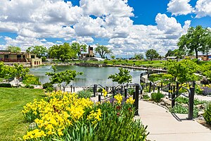
 Ashley Pond Park in Los Alamos, New Mexico | |
 Location within the U.S. state of New Mexico | |
 New Mexico's location within the U.S. | |
| Coordinates: 35°52′N 106°19′W | |
| Country | |
| State | |
| Founded | 1949 |
| Seat | Los Alamos |
| Largest community | Los Alamos |
| Area | |
| • Land | 109 sq mi (280 km2) |
| • Water | 0.09 sq mi (0.2 km2) 0.08% |
| Population (2020) | |
| • Total | 19,419 |
| • Density | 178/sq mi (69/km2) |
| Time zone | UTC−7 (Mountain) |
| • Summer (DST) | UTC−6 (MDT) |
| Congressional district | 3rd |
| Website | www |
Los Alamos County comprises the Los Alamos Micropolitan Statistical Area, which is also included in the Albuquerque–Santa Fe–Las Vegas combined statistical area.
The county is home to the Los Alamos National Laboratory. Los Alamos County is noted for having the lowest level of child poverty of any county in the United States.[3]
Oops something went wrong:
