


Severe Thunderstorms in Northwest Texas; Critical Fire Weather Concerns in Colorado and Guam
Isolated strong to severe thunderstorms capable of producing large hail and damaging winds will be possible through Tuesday evening across northwest Texas. The combination of dry conditions and gusty winds have led to elevated to critical fire weather concerns across southern Colorado and Guam. Read More >
LOADING...
Click a location below for detailed forecast.
Last Map Update: Tue, Apr. 23, 2024 at 10:32:57 pm CDT
Severe Storms Thursday
Remaining Very Warm
Low Chance of Storms Tue/Wed
Severe storm potential increases on Thursday, with low chances (10- 40%) for storms to become severe across the eastern Permian Basin and Lower Trans Pecos late Thursday afternoon and Thursday evening. Storms that develop will move to the east-northeast. Take action now to prepare - ensure weather alerts on your smart devices are turned on, and have multiple ways to receive warnings. Secure loose objects that could be damaged by strong winds. And plan to shelter vehicles and property from potential hail damage if possible.
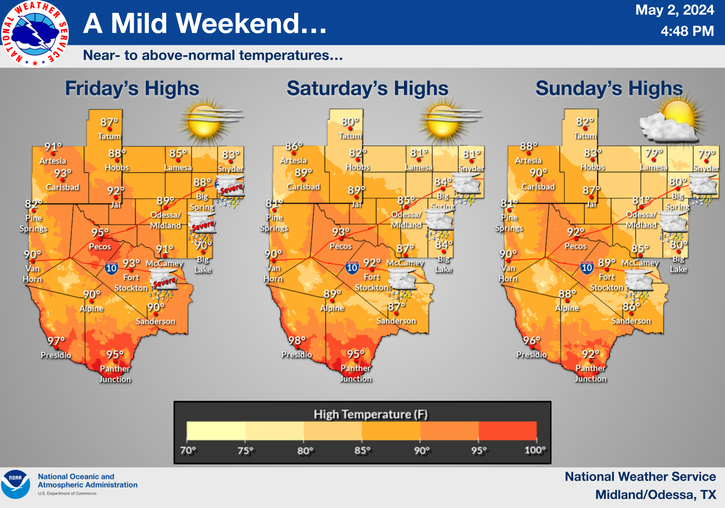
This afternoon and Wednesday afternoon sees the return of and continuation of very warm temperatures across the region. Widespread 80s and 90s can be expected across the area under plentiful sunshine.
There will be a low chance (10-20%) of thunderstorms across portions of the area this afternoon and Wednesday afternoon. Thunderstorms this afternoon will be confined to the northeast Permian Basin and Stockton Plateau. Thunderstorms Wednesday afternoon may reach across the eastern Permian Basin to the Lower Trans Pecos. Keep an eye on the weather as there is a low chance of severe weather should any thunderstorms develop.
|
Text Product Selector (Selected product opens in current window)
|
|
 |
 |
 |
 |
 |
 |
| Storm Reports | Spotter Briefing | Storm Spotters | Storm Data | Tornado Statistics | Social Media |
 |
 |
 |
 |
 |
 |
| Forecast Discussion | Hourly Forecast | Graphical Forecast | Fire Weather | Aviation | Hydrology |
 |
 |
 |
 |
 |
 |
| Observations | Air Quality | Satellite | Climate | Past Events | Weather Radio |
 Local Radar
 Weather Map
 Satellite