Dogs Off-leash


Bikes are not allowed on the PCT. Please respect closures and signage.
Overview
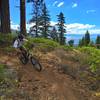
This ride is long and difficult enough to challenge almost any rider, but it's not difficult enough to turn an intermediate rider away. And the rewarding views of the Sierras from the ridge you'll ride along make it worth the work.
Finally, the rocky, technical riding mixed in is enough to keep anyone motivated. It's one of those special, "pleases everyone" type of rides. Don't miss it!
Need to Know
Some people use two cars and shuttle. If you choose this option, continue on I-80 west over Donner Pass and take the Soda Springs exit. Take a right at the bottom of the exit, and take another immediate right at the fire station on Sherritt Ln. Just past the fire station you'll see dirt parking on the left side. This is where the trail will drop you out.
If you dont shuttle, you'll have to ride from here back uphill to your car. This additional section is just under 5 miles. The ride is written up as a complete loop, so if you shuttle, take 5 miles off of the total, and about 800 feet of climbing.
Description
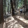
Follow the jeep road west, and almost immediately you'll see a road to your left. Continue straight west for 1.1 miles and you'll see a large Forest Service sign with a map of your trip. This is where your singletrack starts.
Take a left on the singletrack, and you'll quickly gain just over 500 feet in 1.6 miles (2.7 miles from the start). The trail now drops down the west side of the ridge, and this is where the technical section starts, so be careful. Continue for 1.8 miles (4.5 miles) where you'll encounter a singletrack coming in from your right. This singletrack takes you to the Peter Grubb on the Pacific Crest Trail (no bikes). This is a good shelter to know about if you get stuck up here in bad weather.
Continue for 1 mile (5.5 miles) and you'll come to another fork in the trail. If you take a left, you can ride to Sand Ridge Lake, which is only 1/4 mile off of your path, and worth the view. Retrace your path, and take a left at the fork in the trail. Continue for 3.2 miles (9.2 miles) and you'll cross directly over a jeep road.
Continue over the jeep road, and the trail continues past Hole in the Ground Lake which you'll never see, and to my knowledge, has no trail to it. Anyway, continue on the singletrack for .8 miles (10 miles) where you'll again come to a fork in the trail. If you take a right, you'll travel .1 miles (10.1 miles) to Lower Lola Montez Lake. This is a great spot to take a break.
Once refreshed, retrace your steps back to the main trail and take a right. Continue on the singletrack and in .4 miles (10.6 miles) the singletrack will turn into a jeep road. Follow the jeep road for 1 mile (11.6 miles), and you'll see a singletrack drop off to the left. This is probably the most technical part of this ride. It drops 350 feet in 1/2 mile (12.1 miles) and is very loose, and rocky.
At this point you drop out on the same jeep road you left above. Follow this jeep road for .9 miles (13 miles) where again, you'll see a singletrack veer off to the left. Take the left, and follow the singletrack for 1/4 mile (13.25 miles) and you'll end up on Sherritt Ln, a paved road. Take a right on Sherritt Ln and follow it down hill for 1/4 mile (13.5 miles) to Donner Pass Rd where you'll take a left and cross over I 80.
Continue on Donner Pass Rd. until you pass the small town of Soda Springs at .9 miles (14.5 miles). In 12 mile (15 miles) you'll see a large wooden sign on your left that says University of California Sierra Snow Research Libratory. Take a left on this road. I have never seen a street sign on this road, but according to the map, it is called Bunny Hill Road. This section of road will travel 1.5 miles (16.5 miles) in a northerly direction and parallel I-80 back to the Boreal Ski Resort parking lot. Continue through the parking lot to the far side, and take a left out of the parking lot and travel under I-80 on your left.
This is the road you came in on. Follow the paved road uphill back to your car.
Contacts
Shared By:
Michael Ahnemann
with improvements
by Ashley Seaward

 Continue with onX Maps
 Continue with Facebook


 Difficult

 4.3 (93)


15 Comments