TAMPA, Fla. — A map considered to be the very first map of the Florida peninsula is going on display at the Tampa Bay History Center.
“The Shape We’re In: Early Maps of Florida” exhibit opens Sept. 19, showing off the earliest maps of the Sunshine State before it was known as a state or even as Florida.
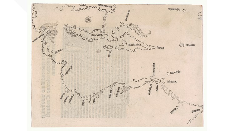
One of the maps on display is the incredibly rare “Peter Martyr” map, printed in 1511 – two years before European explorer Ponce de Leon arrived on Florida’s east coast. The map is considered by historians to be the first to illustrate the Florida peninsula.
“It really is a map of firsts,” said Rodney Kite-Powell, Touchton Map Library Director at the Tampa Bay History Center. “It’s the first printed map of the Caribbean, the first map to use the name ‘Cuba,’ and the first map to hint at a large landmass north of the Caribbean.”
The history center said there are only 20 of these Martyr maps in existence.


This map and the others in the exhibit are some of the oldest of our state but are also inaccurate, clearly showing the evolution of how European explorers and cartographers understood Florida’s geography from the 16th century until even as recent as the early 19th century.
Kite-Powell said “early map makers struggled” with charting Florida on paper. Some of the maps in the exhibit show mountain ranges in the state, islands in the interior and even sea monsters lurking off the coast.
“You can really see the shape of Florida come into view as the centuries pass, and as people begin to better understand the contours of the peninsula,” he said. “It’s really neat to see this evolution through maps.”
As many Floridians and history buffs know, Juan Ponce de Leon lead the first official expedition to Florida, landing on the peninsula in 1513. More than 50 years later, Spanish explorer Pedro Menendez de Aviles created the first European settlement in La Florida and in the United States – St. Augustine.
1565 was also the year many historians agree that the "first Thanksgiving" was held on the American continent. When Spanish settlers landed in St. Augustine on Sept. 8, 1565, they celebrated with a Mass of Thanksgiving and then shared a meal with the native Seloy tribe, according to the National Parks Service.
What other people are reading right now:
- Granville Ritchie sentenced to death for murder of 9-year-old Felecia Williams
- Florida bars allowed to reopen at half-capacity starting Monday
- 19 years later: Remembering Sept. 11 through unforgettable photos
- CDC: People who tested positive for COVID-19 twice as likely to report dining at restaurants than those who test negative
- 12-year-old accused of bringing three guns to school, mom tells deputies he recently shot, killed family dog
- She went to a Tampa hospital for surgery. Her family says she left with a deadly infection. She's not alone.
►Breaking news and weather alerts: Get the free 10 Tampa Bay app
►Stay In the Know! Sign up now for the Brightside Blend Newsletter