The Pacific Crest Trail can be wonderful year-round if you’re a hiker who also likes to backcountry ski or does other snow sports. Truly, the PCT is a world-class place for winter recreation! But if you’re only a hiker, you’ll generally aim to head out during the snow-free months. Snow is challenging and can be dangerous. Most people prefer dry trail when hiking.
The weather and snowfall are variable. This page discusses generalized trends and does not fully capture the situation in very dry or snowy years.
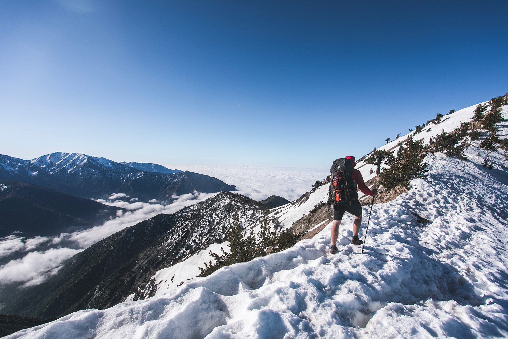
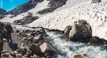
A hiker crosses the mountains of southern California on April 21, 2019, during a heavy snow year. Photo by Joshua Leung.
Make sure to check local conditions and weather forecasts before your trip. Do not assume that weather and trail conditions will be ok or easy. Think conservatively and make sure you will be hiking in conditions comfortable for you.
If you’re heading out early in the season, be aware that you likely will get to places before trail crews have gone out. You may find lots of downed trees or other obstacles.
Here are some resources to check trail conditions before your trip.
Use our interactive map to look at weather forecasts, satellite images and snow data.
When in doubt, ask a friendly front desk staffer at the local land management agency.
The desert is hot. The mountains are snowy. And other broad generalizations.
Summer and early fall are generally the best time to hike in the mountains, while low-lying parts of California are most pleasant in spring and fall. Winter snow buries most of the trail from around October or November into early July. Those looking for normal dry-trail conditions wait until the snow has melted.
Southern California (Mexican Border to Walker Pass)
Don’t be fooled by “the desert.” The PCT often crosses high, seasonally snow-covered mountains in Southern California. You’ll pass ski resorts. Between each mountain range, the trail drops to low elevations and is usually snow-free. Higher elevations typically become snow-covered in the winter, possibly by late October or November, but sometimes not until January. Snow can remain an obstacle into early May, and new snow has been known to fall on Memorial Day weekend. Winter snow is usually deepest in the San Jacinto mountains above Idyllwild (widely, but especially Apache Peak, Antsell Rock, and Fuller Ridge), the San Bernardino mountains above Big Bear (especially south of Coon Creek Jumpoff), and the San Gabriel mountains along the Angeles Crest Highway near Wrightwood (especially on Mount Baden-Powell). At the southern end, Mount Laguna above San Diego gets periodic winter snow. On the northern end, the Piute and Scodie Mountains between Tehachapi and Walker Pass can regularly be snow covered.
Spring, summer, and early fall in this section vary between perfect temperatures and dangerously hot. Spring, from about late March through May and fall (September, October, and November) are the most popular times to go hiking in Southern California. Do not underestimate the heat. It’s not safe to hike in extremely hot temperatures. While winter hiking is wonderful in some of the low-lying parts of this section, mid-summer is just as comfortable at the higher elevations.
Water scarcity is always an issue in Southern California. Plan ahead and prepare for this fact in advance of your hike.
High winds are also a fact of life in the region. They can be strong enough to ruin a trip.
Central California and the bulk of the Sierra Nevada (Walker Pass to Donner Pass)
Like the mountains everywhere, summer is prime time for dry trails in the Sierra Nevada. Early fall can also be nice, but nights are cold. The first winter snowstorms can arrive as early as late-September but typically hit sometime in October, or even as late as November. Fall and winter can also be extremely cold.
The southern portion of this section, between Walker Pass to the high meadows around Kennedy Meadows, gets winter snow, but it’s usually less deep and the snow season is shorter. It can be a good place to hike in the spring and fall shoulder seasons.
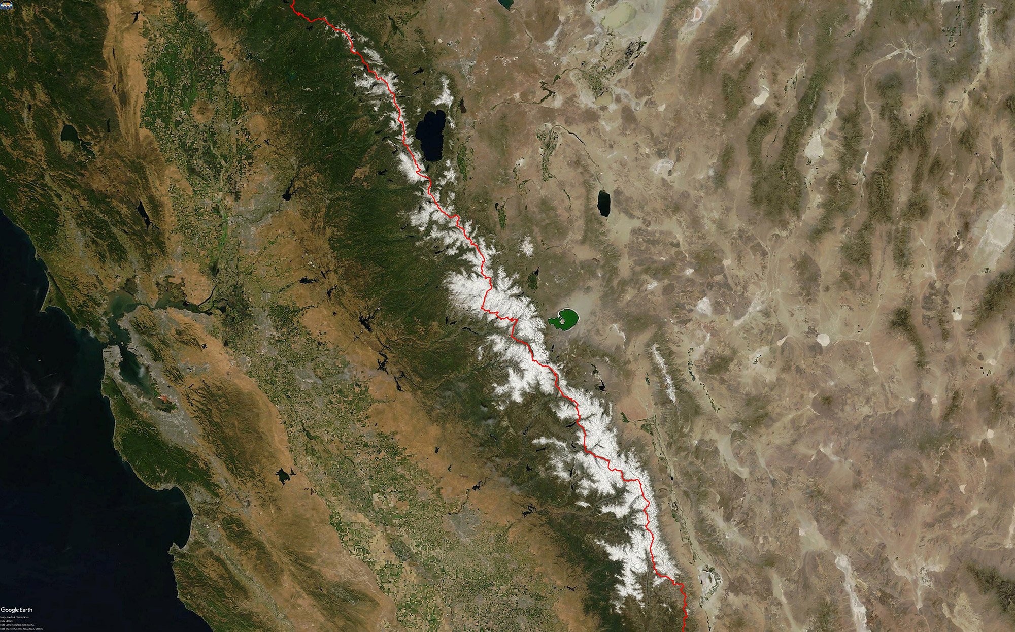
Snow blankets the Sierra Nevada on June 17, 2017, a heavy snow year. Travel was difficult and there were multiple fatalities.
Snow usually stops accumulating and begins to melt sometime in April or May, but moderate-sized snowstorms are not unheard of in June; and light snow falls even in the middle of summer. May and June are generally a hazardous time to hike in the Sierra — much of the trail will still be covered in snow and creeks will be full of fast-moving water, making fords dangerous.
In a normal year, mid-June is generally considered to be an early time to be in the high country. You’ll find snowy passes and flooding rivers that will test your body and risk tolerance. It’s not until a good bit after July 4 that conditions are generally summer-like everywhere. If you’re attempting to travel the Sierra portion of the PCT in May or the first half of June, beware. May is often prime ski season in the backcountry. You might find yourself in the snow all the way to Canada, including down in the valley bottoms. Conditions have not gotten easier yet — you’re a month or more too early for normal backpacking on dry trail.
Don’t be fooled into thinking the Sierra Nevada’s northern extent is around Yosemite. The mountain range continues north for another 350 trail miles. Before early July, it’s likely snowy throughout the range. A few day hikes melt off first, but as this is a high elevation section, it takes a while before backpacking becomes easy. To be clear: even the Tahoe to Yosemite section and the Lake Tahoe section can hold difficult snow in June and July.
This region includes some steep snow slopes that present a real risk of long falls. To name a few notorious ones: Forester Pass, Glen Pass, Mather Pass, both sides of Sonora Pass, Raymond Peak, and Dicks Pass.
The region is also home to dangerous stream crossings when water is high. To name some, but not all: Rock Creek, Tyndall Creek, South Fork Kings River, Evolution Creek, Bear Creek, upper crossing of North Fork of Mono Creek, Silver Pass Creek, White Fork, Return Creek, Spiller Creek, Matterhorn Creek, Piute Creek, Kerrick Creek, Stubblefield Canyon, and Falls Creek.
In mid-June of an average to heavy snow year, you’re likely to start encountering snow a little north Mulkey Pass (mile 745). At that time of year, the snow extends north all the way to the Quincy region.
Northern California (Donner Pass to the California/Oregon border)
In Northern California, the trail stays in the mountains as it transitions from the Sierra Nevada to the chain of Cascade volcanoes and takes a “big bend” around Mount Shasta into the Klamath Mountains.
As is typical in the mountains: winter is snowy, snow persists into early summer and summer is beautiful at high elevations and hot at low elevations. Most people wait for dry summer trail. As summer progresses, wildfire impacts, like smoke, become more likely.
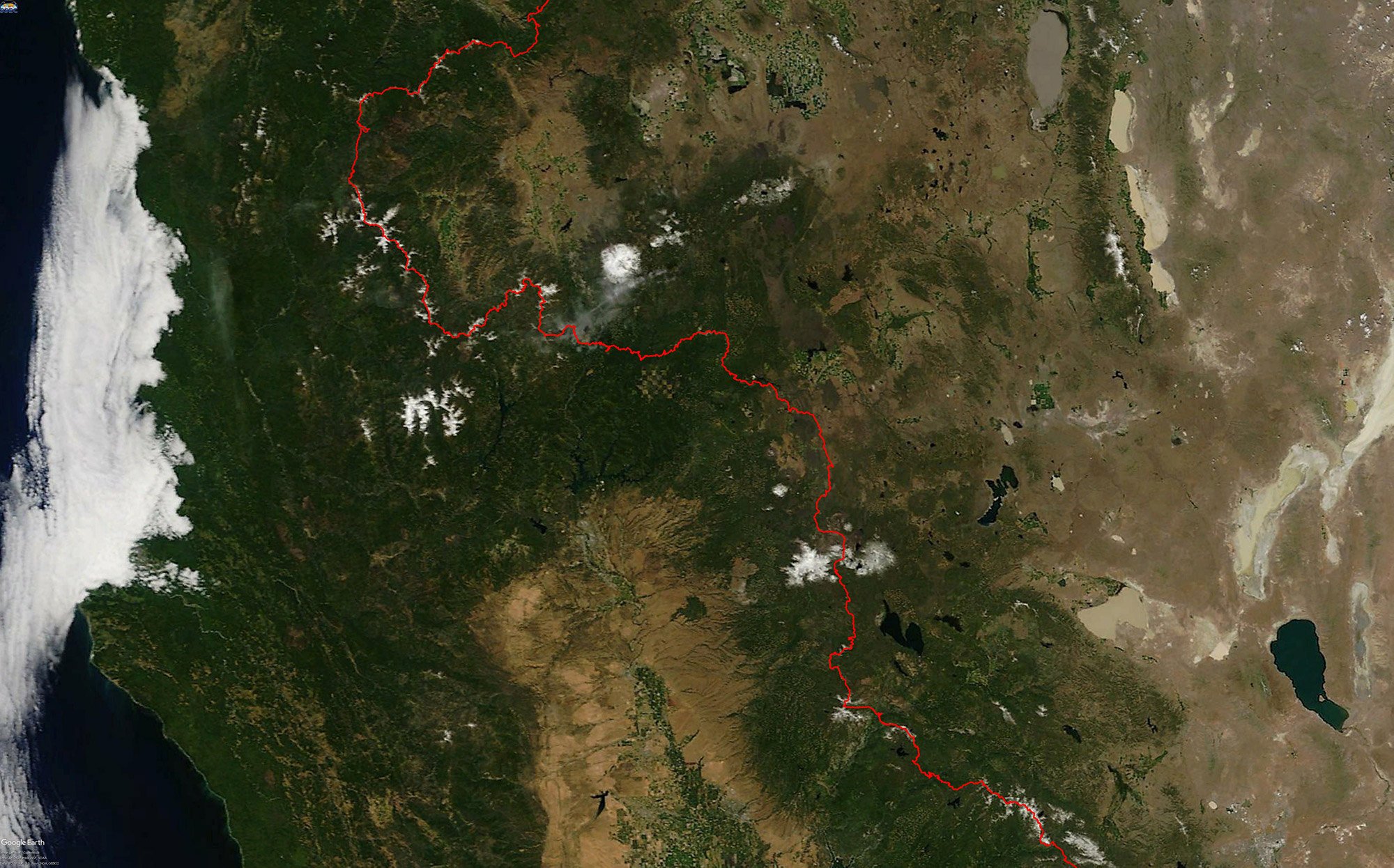
The PCT, being at the top of the mountains remained blanketed in snow for most of northern California during the heavy snow year of 2017. Satellite image was taken on June 17, 2017.
From Donner Pass to Lassen Volcanic National Park, the trail will be snowy until around July 1. Lassen, being a relatively high area, often holds snow a little longer. North of Lassen until it crosses Interstate 5, the trail stays at a lower elevation and is more likely to be snow free at least a few weeks earlier. Hat Creek Rim gets some winter snow but it usually doesn’t last long. The trail there is likely to be entirely snow-free by late April. Just north of there, the higher elevations between Red Mountain and Grizzly Peak can hold snow to late June. Otherwise, the region between Burney Falls and I-5 should be snow free around mid-June.
This whole region, but especially the lower elevation climbs, can be very hot in summer.
North of I-5, the PCT climbs (very hot mid-summer) into the Klamath mountains and cooler temperatures. The trail is likely to have snow-covered areas until early July. A problem area is a few miles north of Carter Meadows Summit as you enter Russian Wilderness. The trail crests a saddle onto the northwest face of some impressive granite where steep snow often lingers. There is a similar situation on the north and south sides of Etna Summit. Easier early season travel can be found where the trail goes through Seiad Valley, which is at a significantly lower elevation. That section is primarily a road walk so it may not be an appealing hike except as part of a larger trip. The climb north from Seiad Valley is very hot mid-summer.
Snow can start falling in most of Northern California in October, and winter starts in earnest in November. Early fall can be a chilly but beautiful time to explore this section outside of peak season.
Oregon
The Pacific Crest Trail remains at a relatively constant elevation (generally between 5000-7,000 feet) throughout the state. In the lower Cascade Range, which begins at Lassen Volcanic National Park in Northern California, you’ll walk past a chain of volcanoes with forests in between. The border region between Seiad Valley and Ashland, the high Siskiyou Crest, often holds snow into late June. Further north, the shoulders of the volcanoes get deeper snows and hold it longer into summer, especially along north-facing ridges where deeply shaded forests protect the snow from melting. Snow begins melting quickly in May, and the trail is usually mostly snow-free by early to mid-July. Snow lingers on the high mountains: Devils Peak, Union Peak, Crater Lake, Mount Thielsen, Howlock Mountain, Diamond Peak, The Twins, Irish Peak, the Three Sisters, Mount Washington, Three Fingered Jack, Mount Jefferson, and Mount Hood. Mosquitoes can be terrible in June and July. August and September are great months to go out. The snow should be gone by then and the mosquitos become less troublesome as the summer wanes. However, this is also wildfire season, so the trade-off is a risk of thick smoke and trail closures.
Early summer hikers will find the best chance of snow-free trail between Siskiyou Summit (I-5) and Lake of the Woods Highway (Hwy 140). North from there, if you can get on around Mount McLoughlin, you might find snow-free trail through Luther Mountain in Sky Lakes Wilderness. Day hikers might enjoy early season hikes in June near Willamette Pass (Hwy 58) and Santiam Pass (Hwy 20). Olallie Lake to the Mount Hood Highway (Hwy 35) melts earlier, with the Timothy Lake area and the Columbia Gorge area having the longest snow-free seasons. The popular trip from Mount Hood to the Columbia River holds troublesome early season snow on the mountain until you’re north of the Sandy River.
Blanketing snows can come in early October, but in some years, areas may be passable (although cold!) through the month.
Washington
Hiking season is short in the North Cascades. Washington’s deep snows persist well into summer. With many steep traverses, it’s usually best to wait until all the snow has melted in mid to late July or August. Even then, there may be a few snowfields to cross. Those with the fortitude for dangerous snow can consider starting a trip in early to mid-July, but June is almost always very early at high elevations.
Snow holds later in the season around: Mount Adams, Goat Rocks, the ridges of William O. Douglas and Norse Peak wilderness areas, next to Mount Rainier and most of the way from Snoqualmie Pass to Canada. Steep snowfields are too numerous to mention, but highlights include the wilderness areas of Goat Rocks, Alpine Lakes, Glacier Peak, and Pasayten.
Early season hikers will look to do short trips around: the Columbia River Gorge (which is often snow-free year-round), perhaps all the way north to Crest Camp just south of Indian Heaven Wilderness; a day hike on either side of Forest Road 23 south of Mount Adams; around the river valleys near Stehekin: south down the South Fork of Agnes Creek or north through North Cascades National Park to Highway 20.
Recent history has brought season-ending snowfall as early as the last week of September. So while the fall colors are spectacular, it is very important to keep an eye on the weather forecast and to be thoroughly prepared.