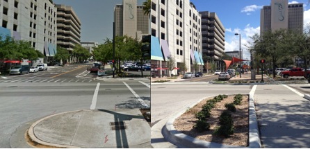
LED BY FEI-FEI Li, the director of the Stanford University artificial intelligence lab and a newly minted Google employee, a team of academics recently explored a new way of tracking socioeconomic trends across the US. Rather than knocking on doors and asking questions, they pulled more than 50 million photos from Google Street View and fed them into neural networks. The results were promising. Simply by identifying the make, model, and year of automobiles appearing in the photos, the researchers said, their tech could accurately estimate the income, race, education, and voting patterns of citizens in particular precincts.
If the number of sedans on a short stretch of road exceeded the number pickup trucks, for instance, they found that a city was 88 percent likely to vote for a Democrat during the next presidential election. If pickups exceeded sedans, a city was 82 percent likely vote Republican. “Our results suggest that automated systems for monitoring demographic trends may effectively complement labor-intensive approaches, with the potential to detect trends with fine spatial resolution, in close to real time,” the researchers write in a recently-released paper detailing this study.
Fei-Fei and her colleagues declined to discuss their project because the paper is still under peer review. But their work reflects a much larger effort to gain more insight into broad societal and economic trends through new sources of data, crowdsourcing, and machine learning. In the years to come, machines—not statisticians—will paint the more accurate picture of how humans think, live, and spend.
At a San Francisco startup called Premise, machines parse data collected by an army of people spread across the world, building real-time consumer price indexes. A Palo Alto startup, Orbital Insight, uses artificial intelligence to analyze photos taken by satellites, identifying economic trends from what it finds. And various other researchers have predicted unemployment rates and poverty using everything from Twitter to cellphone metadata.
Fei-Fei and her collaborators see their methods as a replacement for the American Community Survey, a $250 million-a-year study conducted by the US Census Bureau that identifies a vast array of American demographic trends. Online data and machine learning, the researchers say, will reduce the cost of door-to-door demographic studies like these while providing greater accuracy. Door-to-door surveys, after all, don’t operate in real time. They’re out of date before they’re finished.
The methods outlined in Fei-Fei’s study still require some on-the-ground data gathering to establish a baseline from which AI-powered techniques can extrapolate. But most of the process is automated. Well-trained neural networks can recognize the make, model, and year of cars in photos with much greater efficiency than humans. As described in the paper, the system needs only one-fifth of a second to sort a vehicle into any of 2,657 categories.
But if Street View photos offer one kind of insight, the view from space offers another path to automated forecasting. Orbital Insight now tracks 250,000 parking lots outside 96 retail chains across the country and uses the number of cars in lots as an indicator of company health. This quarter, for instance, the number of cars in JCPenney lots fell 10 percent. Not surprisingly, perhaps, the retailer just announced the closure of about 130 stores amid declining sales. Premise, meanwhile, pays a network of people across the developing world to collect economic data on the ground—the price of canned coffee in a particular town, for instance, or the freshness of the lettuce on sale in another. Using machine learning techniques similar to those used to analyze Street View and satellite images, the company can then looks for price patterns.
Apply these methods across multiple retailers and multiple industries, and you have what starts to look like an unprecedented collection of economic indicators. Machines can detect patterns that humans can’t, or at least with much greater speed and accuracy. As they get smarter, the promise is that these automated forecasts will provide a foundation not just for better economic planning but a better democracy. In a political climate beset by deniers of facts, the hope remains that better information will yield better decisions by the people with the power to make them.
Source: www.wired.com