6 Best Free Google Earth Alternative Services
Here is a list of best free Google Earth Alternative Services and software. Google Earth is a popular service to explore the earth, find locations, get directions, and find nearby services. It also offers an interactive 3D earth map with satellite imagery to view and analyze any location that you want. Now, in case you are looking for its alternative, I have created this list of Google Earth’s alternative services and software. Most of these are online services that offer an interactive world map with satellite imagery. Plus, virtual street map to view routes and plan trips are also available in most services. Similar to Google Earth, you can use your mouse to pan and zoom-in on the interactive world maps of these alternatives. Through these services, you can also easily find monuments, cities, popular buildings, etc., by using their names.
Apart from locating nearby locations and monuments, you can also use most of these alternatives to find routes between two locations. To find routes, these services offer a navigation feature similar to Google Earth. Using the navigation feature, you can find shortest routes and alternative routes along with time estimate to reach your destination. Plus, the real-time traffic status of your current routes is also provided by most of these Google Earth alternatives. These services also let you share a location and map with other users and on social media platforms. There are many other features that you can find in these alternatives. Go through the list to know more about these services.
My Favorite Google Earth Alternative Service or Software:
Marble is my favorite alternative because it is closest to Google Earth in terms of features. In it, you can find all the major Google Earth features like Satellite View, Street View, Navigation, Location Search, and more.
HERE WeGo is a good online alternative of Google Earth that you can try if you need real-time traffic updates and multiple routes suggestions.
You can also check out lists of best free BlueStacks Alternative, Visio Alternative, and QuickBooks Alternative software for Windows.
Marble
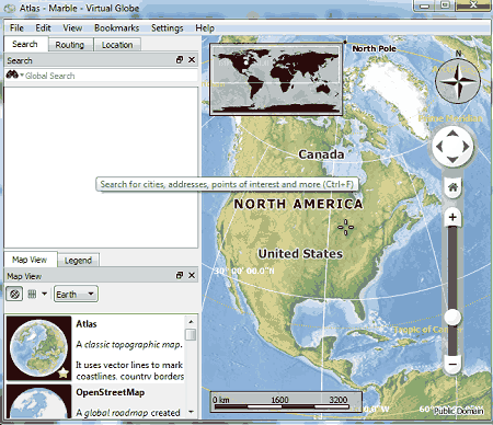
Marble is a free Google Earth alternative software for Windows, Linux, Android, and macOS. In this software, you can explore the earth just like Google Earth. Plus, it lets you search for any location on the earth that you want to closely view. It also offers multiple maps such as Atlas, OpenStreet Map, Satellite View, Earth at Night, and more. Besides this, you can also use it to find the faster routes between two locations just like Google Earth. Let’s take a brief look at the main features of this alternative.
Main Features:
- Map View: It offers multiple map views such as Atlas (it is a classing topographic map of the earth with added coastlines and country borders), OpenStreetMap (it offers a global roadmap to analyze streets and roads of different parts of the world), Satellite View (to view the earth as it is seen from space), Earth at Night (to view the night time view of the earth), and more.
- Simple Navigation: Similar to Google Earth, it also lets you navigate across the globe with the help of mouse strokes. By using the mouse wheel, you can also zoom in or zoom out on the map. Plus, important markings like poles direction, distance scale, attitude & longitude, etc., are also present in it.
- Search & Routing: Through these features, you can search for any location by its name. Plus, they also help you find the optimum route between two locations.
- Bookmark: Use it to save the longitude and latitude information of a location in the form of the Bookmark.
- View: Using it, you can adjust the viewing experience by enabling or disabling the atmosphere, eclipse, clouds, compass, elevation profile, scale bar, overview map, etc., from the earth view.
Additional Features:
- Export Map: Use it to select and export a selected part of the map in the form of JPG and PNG images.
- Work Offline: By enabling this mode, you can view and analyze existing maps without the need for an active internet connection.
Final Thoughts:
It is one of the best free Google Earth alternative software that offers a good set of earth exploring, navigation, and location search features.
HERE WeGo
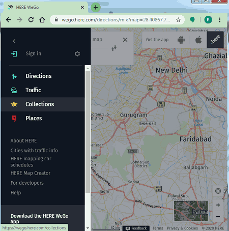
HERE WeGo is another free Google Earth alternative service. Like most other software it is also an online map service. Although Android and iOS apps of this service are also available. It offers all the main features that Google Earth offers like Earth View, Simple Map Navigation, Location Search, Directions, Traffic, and Places. Let’s take a brief look at the main features of this Google Earth alternative.
Main Features:
- View: Using it, you can quickly switch between Classic, Satellite, and Terrain views. The Classic view offers a virtual map highlighting the roads, streets, and area names. On the other hand, the Satellite view shows the actual satellite pictures of a location along with secret/ road names, and nearby places names. The last Terrain view is similar to the Classic view. Although unlike the Classic view, it also helps you visually identify the terrain of a location by using colors like green to highlight forest area, yellow to highlight desert, etc.
- Search Location: Using it, you can find any location and popular monuments over the map using their names.
- Directions: Use it to find the distance and set of routes between two locations. It also shows the time estimate to reach the destination using different transport modes like car, transit, motorcycle, etc.
- Traffic: Use it to view the real-time traffic situation of a specific route.
- Places: It shows all the nearby monuments, restaurants, museums, restaurants that you can visit.
Final Thoughts:
It is another easy to use Google Earth alternative through which you can explore world map, nearby locations, track traffic, and get directions.
Bing Maps
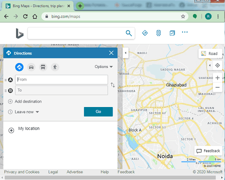
Bing Maps is yet another free Google Earth alternative service. It is an online map service in which you can view traffic and satellite view of various parts of the earth just like Google earth. It also makes it easy to find nearby monuments, grocery stores, restaurants, amusement parks, etc. With its help, you can also find directions of a location along with the current traffic status of your route. Now, check out some of the main features of this Google Earth alternative.
Main Features:
- View: As mentioned earlier, it offers two main views namely Road (Traffic) or Ariel (Satellite) view. The Road view only shows a street map of a location highlighting the traffic and route associated information. The Ariel view shows the actual satellite pictures of a location that you can closely analyze.
- Directions: Use it find out the shortest or traffic-free route of a destination location. It also marks the routes in various colors to highlight the traffic congestion like red color (heavy traffic), yellow color (light traffic), orange color (moderate traffic).
- Nearby Locations: In it, you can explore all the nearby locations such as restaurants, monuments, gas stations, etc.
- Simple Navigation: It offers the same set of navigation features that you get in Google Earth such as mouse wheel movement to zoom in on a location, grab and flick to move around the map, etc.
- My Places: By logging in to Microsoft account, you can also save your home and office locations to quickly navigate to saved locations and find the traffic status of that route.
Additional Features:
- Embed a map: Use it to generate an embed code for a portion of the map that you want to incorporate to a website.
- Share: Using it, you can easily share a location or an entire area with other users on social media platforms like Facebook, Twitter, etc.
Final Thoughts:
It is another very capable Google Earth alternative that offers an interactive world map to view locations, navigate between locations, and analyze the current traffic situation of a route.
mapquest
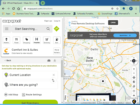
mapquest is one more free Google Earth alternative service. It is a simple online map service that lets you view and navigate around the world map. It mainly offers two viewing modes namely Sattelite and Map view just like Google Earth. Plus, it also highlights traffic, landmarks, borders, etc., on the map. Similar to Google Earth, you can also move the map and zoom in on a specific location using the cursor and mouse wheel. However, unlike Google Earth, it shows a lot of ads on its interface. Now, check out the main features of this service.
Main Features:
- Map View: It offers two map views namely Map and Satellite. The standard map view shows a virtual world map that helps you identify traffic routes, landmarks, etc. On the other hand, the satellite view shows real satellite images of the earth. Plus, similar to Google Earth, it lets you closely view actual monuments, houses, and buildings.
- Traffic View: Using it, you can view all the traffic slowdown areas, traffic incidents, and actual traffic webcam views.
- Search Nearby: Using this service, you can find various nearby restaurants, hospitals, shopping malls, grocery shops, etc.
- Booking: Unlike Google Earth, this feature lets you book flights, hotels, and rental cars. For bookings, it uses Priceline.com.
Additional Features:
- Share: Use it to share a map of a specific location over the social media or generate embed link to incorporate the map to a website.
- Print: Using it, you can save maps along with the list of nearby locations in the form of the PDF document.
Limitation:
- It shows multiple ads on its interface.
Final Thoughts:
It is another decent Google Earth alternative that you can use to view and analyze traffic and locations of different parts of the world.
Waze Live Map
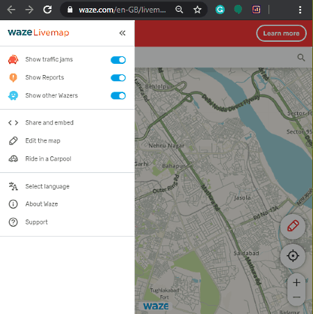
Waze Live Map is the next free Google Earth alternative service. You can also use this service from your Android and iPhones using the Waze app. This service is mainly built to help drivers find out the best routes in real-time. Plus, it also shows real-time traffic jams and recent incidents that happened on your route. Similar to Google Earth, it can also be used to search any location or monument by its name, overview the map of any area, and zoom in on a location. Although it lacks the important satellite view feature.
Main Features:
- Interactive Street Map: It offers a virtual map of the world through which you can find routes, analyze routes, view all the nearby locations, view street. road names, etc. Plus, similar to Google Earth, you can zoom and pan the map through the mouse.
- Directions: Use it to find out the optimum route between any two locations. It also offers multiple alternative routes that you can take to reach your destination. During your trip, it also incorporates real-time traffic information and incidents occurred in your route.
- Edit the map: By signing in to Waze account, you can edit and add information about a route like new restaurants, monuments, and any other popular location.
- Search: It is a simple search feature through which you can find the location of an area, monument, building, etc., over the Waze map.
Additional Features:
- Waze Carpool: Using it, you can book a shared taxi. However, this service is only available in selected countries namely the US, Mexico, Brazil, and Israel.
Final Thoughts:
This Google Earth alternative offers an intuitive world map along with essential direction and location search features.
RAND MCNALLY
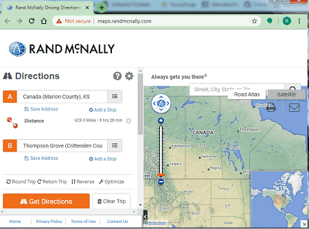
RAND MCNALLY is another free Google Earth alternative service. It is a US-specific online map service through which you can quickly explore various parts of the United States. Plus, it also helps you find routes between any two locations of the United States. Although, you can still use its world map to view and explore different parts of the World. Now, check out the main features of this software.
Main Features:
- Map View: It offers two map views namely Road Atlas and Satellite view. The Road Atlas shows a virtual world map highlighting the roads, road names, intersections, etc. The Satellite view shows the actual satellite images of the world through which you can view actual pictures of a location, monument, buildings, etc. Plus, you can easily zoom in on any location or monument to closely analyze it. Through your mouse, you can grab and move the world map to move over different countries as its internal search feature does not search places outside of the United States.
- Directions: Use it to find the optimum routes between two locations within the United States. You can use it to plan the round trip routes and return trips.
- Search: Using it, you can locate any area, monument, building, etc., within the United States by typing its name.
Additional Features:
- Print: After finding the optimum route for a trip, you can print or save it in the form of the PDF document.
- Share Directions: Use it to quickly share the trip directions with others through Email.
Limitations:
- The search and direction features of this service only work for the locations within the United States.
Final Thoughts:
It another easy to use Google Earth alternative that you can try if you live in the United States.


Naveen Kushwaha
Passionate about tech and science, always look for new tech solutions that can help me and others.
About Us

We are the team behind some of the most popular tech blogs, like: I LoveFree Software and Windows 8 Freeware.
More About UsArchives
- April 2024
- March 2024
- February 2024
- January 2024
- December 2023
- November 2023
- October 2023
- September 2023
- August 2023
- July 2023
- June 2023
- May 2023
- April 2023
- March 2023
- February 2023
- January 2023
- December 2022
- November 2022
- October 2022
- September 2022
- August 2022
- July 2022
- June 2022
- May 2022
- April 2022
- March 2022
- February 2022
- January 2022
- December 2021
- November 2021
- October 2021
- September 2021
- August 2021
- July 2021
- June 2021
- May 2021
- April 2021
- March 2021
- February 2021
- January 2021
- December 2020
- November 2020
- October 2020
- September 2020
- August 2020
- July 2020
- June 2020
- May 2020
- April 2020
- March 2020
- February 2020
- January 2020
- December 2019
- November 2019
- October 2019
- September 2019
- August 2019
- July 2019
- June 2019
- May 2019
- April 2019
- March 2019
- February 2019
- January 2019
- December 2018
- November 2018
- October 2018
- September 2018
- August 2018
- July 2018
- June 2018
- May 2018
- April 2018
- March 2018
- February 2018
- January 2018
- December 2017
- November 2017
- October 2017
- September 2017
- August 2017
- July 2017
- June 2017
- May 2017
- April 2017
- March 2017
- February 2017
- January 2017
- December 2016
- November 2016
- October 2016
- September 2016
- August 2016
- July 2016
- June 2016
- May 2016
- April 2016
- March 2016
- February 2016
- January 2016
- December 2015
- November 2015
- October 2015
- September 2015
- August 2015
- July 2015
- June 2015
- May 2015
- April 2015
- March 2015
- February 2015
- January 2015
- December 2014
- November 2014
- October 2014
- September 2014
- August 2014
- July 2014
- June 2014
- May 2014
- April 2014
- March 2014
