Bury Interchange
Bury Interchange is a transport hub in the town of Bury, Greater Manchester, England. Opened in 1980, it is the northern terminus of the Manchester Metrolink's Bury Line, which prior to 1992 was a heavy-rail line. It also incorporates a bus station.Photo: Paul Anderson, CC BY-SA 2.0.
Photo: Zackhally, CC BY-SA 4.0.
- Type: Bus stop
- Description: Transport hub in Bury, Greater Manchester, England
- Wheelchair access: yes
Notable Places in the Area
Fusilier Museum
Museum

Photo: David Dixon, CC BY-SA 2.0.
The Fusilier Museum is a museum in Bury, Greater Manchester, England. Fusilier Museum is situated 440 feet northwest of Bury Interchange.
Bury Bolton Street railway station
Railway station
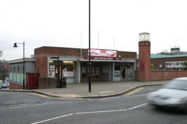
Photo: R lee, CC BY-SA 2.0.
Bury Bolton Street railway station is a heritage railway station in Bury, Greater Manchester, England. Bury Bolton Street railway station is situated 910 feet northwest of Bury Interchange.
Bury Transport Museum
Museum
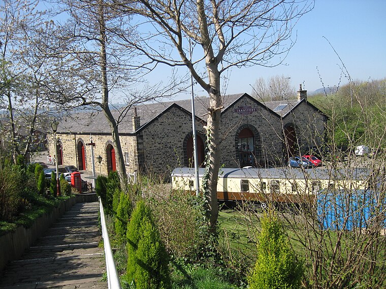
Photo: Chemical Engineer, CC BY-SA 4.0.
Bury Transport Museum is a transport museum in Bury, Greater Manchester, situated in the former Castlecroft Goods Warehouse, a Grade II listed building from 1846, on Castlecroft Road, with the main entrance from Bolton Street, BL9 0EY. Bury Transport Museum is situated 1,400 feet northwest of Bury Interchange.
Localities in the Area
Bury

Photo: jolmartyn, CC BY-SA 3.0.
Bury is a town and borough in Greater Manchester, in the North West of England, ten miles north of central Manchester.
Walshaw
Village

Photo: Wikimedia, CC BY-SA 2.0.
Walshaw is a village forming part of the Metropolitan Borough of Bury, in Greater Manchester, England. Walshaw is situated 2 miles west of Bury Interchange.
Birtle
Hamlet
Photo: michael ely, CC BY-SA 2.0.
Birtle is a hamlet within the Metropolitan Borough of Rochdale, in Greater Manchester, England. Birtle is situated 2½ miles northeast of Bury Interchange.
Bury Interchange
Latitude
53.59127° or 53° 35' 29" northLongitude
-2.29713° or 2° 17' 50" westElevation
318 feet (97 metres)Network
TfGMOpen Location Code
9C5VHPR3+G4OpenStreetMap ID
node 533802603OpenStreetMap Feature
highway=bus_stopOpenStreetMap Feature
public_transport=platformOpenStreetMap Attribute
wheelchair=yesGeoNames ID
7676817Wikidata ID
Q5001099Bury Interchange Satellite Map
© OpenStreetMap, Mapbox and Maxar
Also Known As
- French: Bury
- Welsh: Gorsaf Metrolink Bury
In the Area
Localities
- Buckley WellsSuburb
- FishpoolSuburb
- Woodhill FoldQuarter
- PimholeQuarter
- FernhillSuburb
- GiggSuburb
Other Places
- Bury Interchange STAND JBus stop
- Bury Interchange STAND SBus stop
- Bury Interchange STAND KBus stop
- Bury Interchange STAND TBus stop
- Bury Interchange STAND RBus stop
- Bury Interchange STAND LBus stop
Popular Destinations in England
Escape to a Random Place
Discover the railway station Haymarket Metro station in Newcastle upon Tyne, United Kingdom and the railway stop Farrer Park MRT station in Singapore.
About Mapcarta. Thanks to Mapbox for providing amazing maps. Data © OpenStreetMap contributors and available under the Open Database License. Text is available under the CC BY-SA 4.0 license, excluding photos, directions and the map. Description text is based on the Wikipdia page Bury Interchange. Photo: Paul Anderson, CC BY-SA 2.0.