

During the Cold War the Soviet Union carried out a huge project to create detailed military maps of the west.From the 1940's right up until the 1990's the Soviet military worked on mapping the whole world in very fine detail. One of these detailed Soviet city maps was created for the Northern Ireland city of Belfast.
Soviet Belfast presents the USSR's map of Belfast side-by-side with a modern day street map of the city. The Russian map, at a scale of 1:10000, presents the city of Belfast with street names and other locations labelled in Russian using the Cyrillic alphabet. The modern day map of the city helps to show not only the incredible detail of the Soviet map but also allows you to more easily navigate around a Belfast map written in Cyrillic.
The Soviet map includes 91 'Important Objects', which are presumably locations and facilities in the city that the USSR believe to be of significant strategic importance. These 'important objects' include power stations, pumping stations, army barracks, docks and train stations. If you click on the military hat in the map sidebar you can read these 91 'Important Objects' translated into English.
The Soviet map of Belfast also includes a lengthy 'Reference' section, which presents a general introduction to the city of Belfast. This 'Reference' section describes local social, economic, military resources & statistics. Information that might just prove useful if you had plans to say invade the city.
Hat-tip: GeoConor for both the link to the map and for his detailed Twitter thread on the Soviet Belfast map.
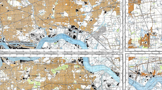
London's East End showing the strategically important docks
You can explore a large number of these Soviet military maps created for other cities around the world on the OpenTiles Soviet Military Maps interactive. On this interactive map you can zoom in and explore thousands of Soviet military maps of Europe, the Middle East and large parts of Asia. The Soviet military created their maps at many different scales. You can use the map layer control to switch between the maps produced at the various different scales.
You can view some of the Soviet military maps created for U.S. cities (and the rest of the world) on GeaMap's Soviet Military Mapping of the World.This map can be a little confusing to navigate as map tiles disappear at some zoom levels. Red stars show where there are Soviet military maps to view. You may have to zoom in very closely on a city before the Soviet Military map appears.
John Davies has written an interesting article on the Soviet military maps for the British Library. Soviet Military Mapping of the Cold War Era includes more information about the composition of the Soviet military maps, the cities mapped and some informed speculation on how these maps were made.
You might also be interested in exploring Germany's Secret Invasion Maps of Britain.
1 comment:
This is brilliant! Really interesting. Thanks a lot for posting.
Post a Comment