Matt Taylor looks back at 70 years of TV weather
- Published

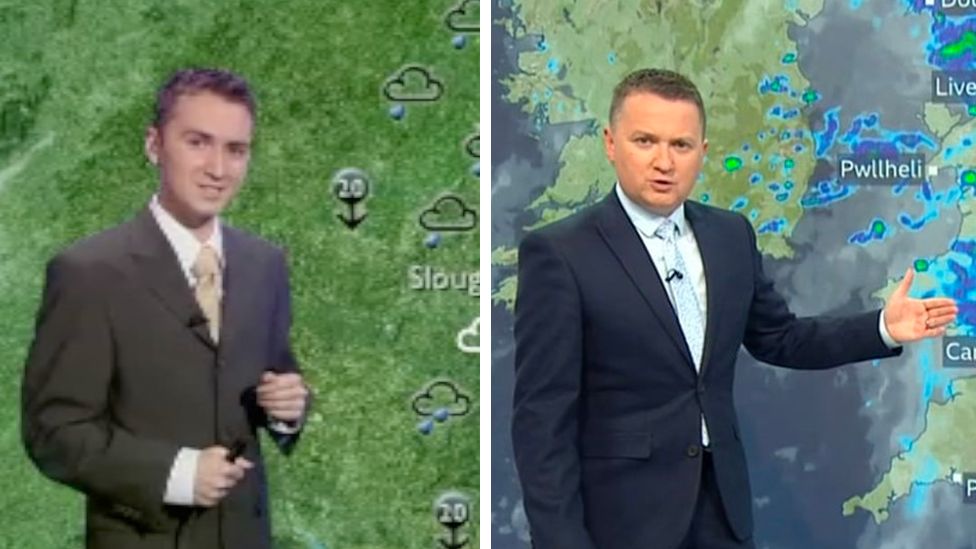
So much has changed in TV weather in just the last two decades. Matt Taylor in 2004 and in more recent times
The nation's favourite conversation went mainstream on 11 January 1954 when the BBC introduced on-screen weather presenters to deliver the daily forecast. Seventy years on the weather forecast remains a steadfast part of TV schedules.
Little did I know, as a young lad obsessed with the weather in a rain-soaked Glasgow, that one day I'd end up delivering forecasts into homes across the world.
A good day to hang out washing
It was 2004 when I walked through the doors of BBC TV Centre and crossed to the other side of the TV screen, 50 years after George Cowling became the very first meteorologist to step in front of the camera.
Today I have a huge range of graphics, computer generated charts and images to illustrate the weather we're experiencing. George and fellow presenter Tom Clifton had nothing more than a couple of charts and a lot of charcoal sticks to draw with.
George Cowling was the first forecaster to appear on air in 1954 and had to draw his own weather charts
When he used the informal approach and suggested that tomorrow would be "good for hanging out the washing" it made newspaper headlines.
But that personal touch became a template for presenters such as me, as we try to take a complex science full of uncertainties and make it accessible and understandable.
Weather presenters soon became household names. We've had songs written about us, our presenting style has been satirized on comedy programmes, and our appearance is sometimes hotly debated.
A female face
Today my BBC Breakfast colleague Carol Kirkwood is a household name but in the early days the faces on TV weather were all male. It wasn't until 1974, a full 20 years after that first on-air forecast, that we saw a woman present the weather, when Barbara Edwards made the move from radio onto TV.
Barbara Edwards was the first female meteorologist to appear on-screen, 20 years after TV forecasts began
The public attention, including the obsession with what she was wearing on air, as well as the attitudes of the time saw Barbara return to radio four years later. But she paved the way for many who followed.
The launch of BBC News 24 in 1997 lead to the biggest increase in the number of weather presenters yet and the arrival of my colleagues Carol, Louise Lear and Helen Willetts.
From charcoal to CGI
We've seen huge changes in technology since that first TV forecast.
Early broadcasts were given in front of hand-drawn charts. The 1970s brought the introduction of magnetic weather symbols, a version of which you can still see today on our broadcasts, website and BBC Weather app. Sadly, I missed out on the opportunity of sticking my favourite symbol - the thundery shower - by hand onto the map.
In 1985 computer technology heralded the arrival of the "green screen" and we presenters went from standing in front of a physical chart to a blank background with our graphics generated behind us.
While viewers at home can see the images behind us, we can only see them on a tiny monitor mounted on the camera.
Two weather icons - the weather symbols, designed by an art student in Norwich, and of course Michael Fish
I'll never forget my early days in the job and the fear I felt hoping that all my graphics were in the right place.
It's still like that sometimes even today. Lots of people don't realise that we don't have an autocue and we speak unscripted to a set length of time, which often changes just before we go on air or occasionally while we're actually broadcasting live.
Forecasting technology
Improvements in computing have seen forecasting accuracy increase dramatically. A four-day forecast these days is now more accurate than a one-day forecast was decades ago, allowing us to look further into the future with our daily broadcasts.
Increases in forecast resolution - how detailed a forecast could be - also meant that a new way of displaying the information was required. The 3D weather graphics were introduced in May 2005. I remember that the look and feel wasn't to everyone's liking but those graphics certainly shaped the way your weather looks on air today.
Advances in technology have revolutionised the detail and accuracy of TV weather broadcasts
The future of forecasting
The abundance of weather apps and websites out there means almost all of us now have forecasts at our finger tips. They're often driven by raw weather model data and don't offer any wider explanation of what is going on and why.
That's why my role as a TV weather forecaster is as important as ever. As well as helping you plan your day, I'm also trying to give you a greater understanding of the intricacies of the forecast and increasingly the role of climate change.
If George was able to join me on my shift tomorrow he'd probably be struck both by how much and how little has changed.
- Published9 January
- Published2 January