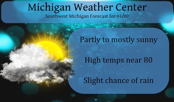
We reached 81° yesterday down here in the valley of Otsego and we have another day which could push to the same temps. Some scattered showers may develop late in the afternoon into the evening. On-and-off downpours and scattered thunderstorms will be more likely on Thursday. This weekend’s weather is unsettled, with a chance for soaking rain between Saturday afternoon and Sunday morning. All of this could mean only one thing – we will be mowing grass very soon. With the promise of soaking rain, it would also be a good time to put out the weed and feed on the lawns.
Weather History for SE Michigan
April 4
On April 4, 2003, a severe two-day ice storm ended over southeast Michigan. The storm was responsible for up to an inch of accumulated ice in Oakland County, which caused 500,000 people to be without power and $50 million in damage!
April 5
On April 5, 1995, Flint had a record low of 13 degrees for the day. The day before, on the 4th, Flint had the same record low of 13 degrees for that day.
Also on April 5, 1982, a snowstorm hit Southeast Michigan in the evening hours and continued into the 6th. The storm moved across the Ohio River Valley and left Detroit with 7.4 inches of snow, Flint with 7.1 inches, and Saginaw with 4.0 inches.
April 6
On April 6, 2010, a prolific hail storm moved from southern Livingston County to southern Macomb County. The storm produced 1.5 inch diameter hail in Brighton, 1.75 inch in Commerce, and 2.25 inch hail in Sterling Heights.
On April 6, 2009, a low-pressure system tracking northeast through the Ohio River Valley produced a late season heavy snowfall across Southeast Michigan. Snowfall totals averaged 1 to 4 inches south of I-94, 4 to 8 inches between I-94 and I-69, and 1 to 4 inches north of I-69. Due to the heavy snow and winds to around 30 mph, tree branches came down which resulted in power outages focused along the M-59 corridor. Some of the higher snowfall included Grand Blanc 6.3 inches, Elba 7.0 inches, Cement City 6.0 inches, Howell 6.3 inches, Shelby Township 6.4 inches, White Lake 7.8 inches, Deckerville 6.0 inches, Ann Arbor 6.0 inches, and Romulus 6.7 inches.
On April 6, 1886, the biggest snowfall ever recorded in Detroit in a 24 hour period occurred with 24.5 inches. This snow had a very high water content (2.43 inches) and was therefore very heavy and packed. This made it difficult for residents and services, such as police and medical, to travel anywhere. Amazingly, the next day temperatures rose to 40 degrees and up into the 50s later in the week.
Also on April 6, 1882, the earliest recorded Michigan tornado outbreak hit Southern Lower Michigan. Six tornadoes rolled across the southern part of the state including Midland, Bay, Livingston and Oakland Counties. In the state there were 10 deaths and 54 injuries as a result of the outbreak. The Midland tornado started just north of Midland and ended near Inwood in Bay County. This tornado was responsible for 1 death and 15 injuries. The Livingston tornado started near Hartland and moved to Clyde in Oakland County. Five homes were destroyed near Clyde where the 3 deaths and three injuries were reported.
April 7
On April 7, 1954, an F2 tornado hit Genesee county at 6:40 pm causing 2 injuries and $25,000 in damages.
April 8
On April 8, 1980, Wayne County was hit by an F1 tornado at 7:15 PM.
On a temperature note, a high of 79 on this date in 2001 broke a 130-year old high-temperature record /76-1871/.
April 9
On April 9, 2016, a late-season snowstorm that begins the night before produced significant snowfall over southern portions of the area. Adrian measured 7.2 inches and 6 to 7 inches fell in Temperance, the Irish Hills, and Manchester.
Also on April 9, 2001, Ann Arbor, Manchester, Saline and Belleville had reports of golf ball size hail during the morning hours. Other areas in Metro Detroit reported 2-3 inch diameter hail.
April 10
On April 10, 1977 the temperature rose from a pre-dawn low of 35 degrees to an afternoon high of 86, or a 51 degree rise, the greatest daily temperature rise ever recorded in Detroit.
Weather History for SW Michigan
April 4
2003: A devastating ice storm strikes central Lower Michigan. Heavy rain from thunderstorms falls into a layer of cold air near the ground and freezes on contact, creating sheaths of ice up to 3 inches thick that brings down thousands of tree limbs. It was estimated that 450,000 homes and businesses lost power during the storm and that nearly 50,000 people were without power for a week as persistent cold temperatures keep the heavy ice on the trees for 4 days after the storm. Crews came from four different states to help local utility companies restore power.
April 5
1982: Arctic air pours into Lower Michigan in the wake of a snowstorm and lake effect snows pile up over a foot across western Lower Michigan. The 12 inches of snow at Muskegon makes this the snowiest April day on record there.
April 6
1882: A tornado outbreak strikes Lower Michigan, killing 10 people and injuring more than 50 others. Tornadoes struck Midland and Kalamazoo Counties, killing one person each. Four people were killed in a tornado that moved between Bedford and Charlotte. Three people were killed in Oakland County by a tornado that passed between Clyde and West Highland. A tornado that struck east of Dansville in Ingham County killed one person. A barn and home were destroyed by a tornado a mile west of Charlotte, but no one was killed.
1997: A strong cold front moved through with a line of thunderstorms producing wind gusts to 70 mph and causing widespread damage across much of southern Lower Michigan.
April 7
1954: A tornado destroyed two barns and damaged a house and apartment building near Fulton in Kalamazoo County.
1982: Temperatures plunge to near zero as arctic high pressure persists over the Great Lakes states. Lansing falls to 2 below zero for a record low for the date and the latest sub-zero temperature on record. Muskegon falls to one degree above zero and Grand Rapids to 3 above for their coldest April temperatures on record.
April 8
1938: A snowstorm drops several inches of snow across southern Lower Michigan. Lansing sets a record for the day with 5.1 inches and Grand Rapids with 4.3 inches.
1947: Three to five inches of rain and warmer temperatures combine with melting snowpack and partially frozen ground to cause some disastrous flooding along the Grand and Kalamazoo Rivers. Millions of dollars of damage occur as large sections of Grand Rapids, including the Comstock Park area, are under several feet of water.
2016: A spring snowstorm drops 4 to 6 inches of snow from Grand Rapids to Lansing. A total of close to 10 inches of snow fell at Grand Rapids during a wintry first week of April.
April 9
1969: A brief tornado damaged a house near Loomis in Isabella County.
1973: A snowstorm dumps 3 to 8 inches of snow across much of Lower Michigan. Record snowfall for the date includes the 6.5 inches at Muskegon, 5.2 inches at Lansing and 4.4 inches at Grand Rapids.
2008: A tornado hit from near Plainwell in Allegan County to Doster in Barry County at 1:40 a.m. It did significant damage to a horse barn, lifted a trailer adjacent to the barn, damaged gravel yard equipment, lofted a tank, and uprooted numerous large trees.
April 10
1977: A three day spell of 80 degree temperatures begins across Lower Michigan. Record highs include the 81 degrees at Lansing, where temperatures would hit records of 82 degrees on the 11th and 83 on the 12th.
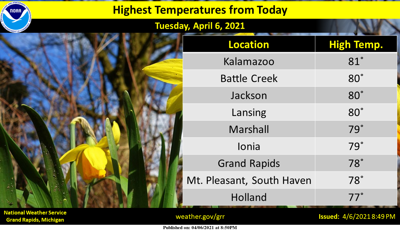
First 80 of the season !It’s only April !
Tenth of an inch of rain yesterday, tenth of an inch today. Reminds me of our “new normal” during the Winter where we get a tenth of an inch of snow at a time.
Todays official high of 78 is the earliest day to reach 78 since 2005. At this time it is rather dark to the west and the current unofficial temperature here is 80 and some rain has just started.
Slim
I assume that should read 2015, correct?
No that is 2005. It did not reach 78 or better in 2015 until May 7th
Slim
GR has hit 78 degrees so far today! Wow!
Just like yesterday, 1 stray shower just came over top of us. It was pouring sideways with the wind, now the suns coming out again. Temp dropped from 80 to 62 and back on the way up.
Sitting out on the deck today getting drunk in the sun getting sun tan woo woo hump day at it’s best ….INDY
Summer in early April continues! My friends opened their pool yesterday. Incredible.
I remember the ice storm from April 2003 pretty well, even though I was only a few years old at the time. I remember sitting in my living room and seeing a powerful lightning strike outside and then losing power. We then went to a hotel the next day and right when we checked in our power apparently came back on so we returned home.
Wow, 24 degrees above average yesterday. Seems we’ve had quite a few days at 20 or more degrees above average over the last 5 or 6 months. Back in November we had that whole week in the 70’s. Crazy stuff.
At Grand Rapids since November 1st there has been 4 days when the mean has been 20° warmer than average. There has been a total of 30 days when the mean has been 10° or more above average. On the flip side there have been 1 day when the mean was 20° below average and a total of 12 days with the mean 10° colder than average. At this time it is sunny and a very mild 68 here.
Slim
What about the daily high temps? That’s more what I was referring to, not the daily mean.
For day time highs there have been 10 that have been 20° or more above average. 2 in November (the 8th and 9th) 1 in December (the 23rd) 0 in January and February 5 in March (the 9,10,11,22 and 23) and so far here in April 2. Yesterday and today. As of today it has to reach 75 or warmer to be +20 for a high and the current official reading at Grand Rapids is 76.
Slim
Interesting stats. It surprises me that we didn’t have more days 20 degrees below average during the “polar vortex” in February, even when using the mean of the day. It is probably easier to achieve +20 from average than -20 from average during the winter anyways.
The mean for the day was -13.1 but with a high of 13 the high on the 15th of February was -21 below average. The coldest mean for the month of -22.1 was on the 17th when the official low was -12.
Slim