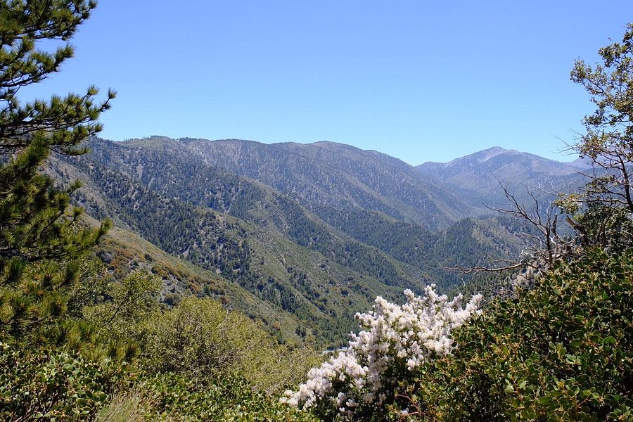
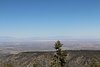
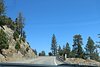
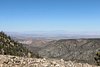
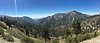
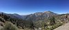
Angeles Crest Highway
Angeles Crest Highway
4.5
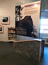
Full view


Top ways to experience nearby attractions


The area
Neighborhood: Central L.A
Reach out directly
Best nearby
We rank these restaurants and attractions by balancing reviews from our members with how close they are to this location.
Attractions
4 within 6 miles
Contribute
Most Recent: Reviews ordered by most recent publish date in descending order.
Detailed Reviews: Reviews ordered by recency and descriptiveness of user-identified themes such as wait time, length of visit, general tips, and location information.
4.5
38 reviews
Excellent
27
Very good
10
Average
1
Poor
0
Terrible
0

CharG1965
Mission Viejo, CA98 contributions
Aug 2020
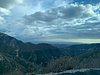
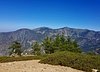
I have never been here and I have lived in Orange County for 33 years. It was a beautiful drive. My husband loves to drive and her really enjoyed all of the switchbacks. I was happy to just be a passenger as if I was the driver I would not have appreciated all of the spectacular scenery along the way. Due to time constraints, we didn't go all the way to Wrightwood (another day when we have more time!) Highly recommend as you feel you are so far detached form civilization, but in reality only a hop skip and a jump from the greater LA area. Bathrooms and picnic areas were open and there were quite a few people gathered at those areas. We wanted to isolate so did not stop there. Tons of hiking and a few overnight camp areas up in the Angeles National forest as well for those more adventurous.
Written August 3, 2020
This review is the subjective opinion of a Tripadvisor member and not of Tripadvisor LLC. Tripadvisor performs checks on reviews as part of our industry-leading trust & safety standards. Read our transparency report to learn more.
joaniemaria
Eldridge, IA2,443 contributions
Mar 2024 • Family
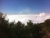
Beautiful views and a curvy highway. You will quickly climb above Los Angeles and the views are amazing. You will feel far away from the city, even though in reality it is nearby. We did not go all the way to the top. The road goes to Palmdale. It would be fun to go to the top when we hav3 more time someday.
Written March 23, 2024
This review is the subjective opinion of a Tripadvisor member and not of Tripadvisor LLC. Tripadvisor performs checks on reviews as part of our industry-leading trust & safety standards. Read our transparency report to learn more.
CATTSAR
Provincetown, MA22,299 contributions
Nov 2012 • Solo
A must if you love the great outdoors!!
I have wanted to do this for years, it was worth the wait. I drove west from Palm Springs on the 10/210 and started at the western end at La Cañada Flintridge. The lighting is better with the sun at your back The day was perfect for this~ pristine so I could appreciate the vistas. As mountain driving goes this is not difficult. The road is in good shape, the curves easy, and there are guardrails! Turn outs are plentiful for pictures, and there are enough passing lanes till you reach the Mt. Wilson cutoff. No gas stations , there are restrooms and a couple cafe's. Pack a lunch, fill the tank and enjoy the ride!
BTW it tops out at about 7,900 ft It'll be cool!
Written November 20, 2012
This review is the subjective opinion of a Tripadvisor member and not of Tripadvisor LLC. Tripadvisor performs checks on reviews as part of our industry-leading trust & safety standards. Read our transparency report to learn more.

Cavydad
Camarillo, CA2,207 contributions
Jul 2017 • Couples
Must do Drive! Began in La Canada Flintridge and goes to the Antelope Valley. Very few straight always and plenty of curves. Take a rest break at Mount Wilson and visit the iconic telescopes and enjoy the view over Los Angeles and on a clear day perhaps Catalina Island. Continue on passing Red Box and have a picnic at Chilao Flats. Do not rush the drive. It's not an ultra marathon. Climb Mount Baden Powell, perhaps an all day hike, but fantastic. Soon you will descend into the Antelope Valley. Buy peaches in Pearblossom or stop at Charlie Browns Farm for a milk shake. The big decision is to backtrack over the mountains again or take Highway 14 home.
Written September 15, 2017
This review is the subjective opinion of a Tripadvisor member and not of Tripadvisor LLC. Tripadvisor performs checks on reviews as part of our industry-leading trust & safety standards. Read our transparency report to learn more.
NikiMustTravel
Huntington, NY147 contributions
May 2016 • Friends
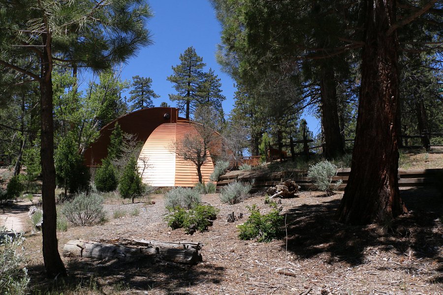
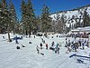
I've lived in the ever increasing congestion of Los Angeles for 15 years now, but had not ventured up the Angeles Crest Hwy until this past year. And I kicked myself the whole way up and back down my first time for waiting so long to get up there! What a beautiful drive through the gorgeous Angels National Forest! There are many turn-offs that hold breath taking views, aka plenty of camera ops!. There is little to no cell reception once you climb past 3,500 feet, but who the heck do you want to be chatting with when you've got vistas to behold?! There are also several hiking trails and even a few different sections of the famous Pacific Crest Trail you can take too. Don't forget to get your day pass or have your Annual park pass in order to park there for more than any length of time. (Day pass $5, Annual pass $30.) Recently I ventured all the way across from La Canada to Wrightwood and camped at Table Mountain ($20 per night) located at 7,200ft - cold but gorgeous! We stumbled upon many trails and campsites along our journey that will bring me back to these mountains all summer. But if you're just planning a day trip, at least head up to 5,400ft to Newcomb's Ranch, which is about at the half-way point, and join the bikers for a burger!
Written May 24, 2016
This review is the subjective opinion of a Tripadvisor member and not of Tripadvisor LLC. Tripadvisor performs checks on reviews as part of our industry-leading trust & safety standards. Read our transparency report to learn more.
Robert F B
Reston, VA1,089 contributions
Aug 2015 • Solo
I first heard of Mount Wilson on my first visit to Los Angeles when I was 14. On our first night in Pasadena I caught the sign-off KBSC-TV, channel 52 a little before 10 that evening. They mentioned that their transmitter was located on “Mount Wilson, 5,700 feet above sea level:". Well, coming from a place where the tallest TV tower was 1,117' above sea level with most of the others much lower, this was impressive. Eight years later, on my first trip to L.A., where my parents finally let me have the rental car to myself, I finally got to drive up to Mount Wilson when I tagged along with a bunch of fellow ham radio operators to track down an unknown transmitter. I was impressed! All of the major L.A. TV and FM stations have their transmitter sites up there. And, when I went back in August 2015, there were sttll a lot of the old analog TV antennas on the short towers that are a Mount Wilson hallmark along “Video Road." How short? More than a few are unlit! Check the web for the various websites that detail the broadcast history of Mount Wilson and show the transmitter sites up there. Do be aware that for a lot of very good reasons, the transmitter sites on Mount Wilson are securely fenced in with most of them under video surveillance from the TV stations. It is unwise to even linger. Also, if you have a cardiac pacemaker, ask your cardiologist before you make the trip to the mountain. There are many high-power transmitters up here that create some of the highest RF field levels of such a comparatively small area anywhere in North America, if not the world. There is enough RF up there to possibly throw off the operation of a pacemaker. The RF level is such that the post office up there has perhaps the shortest hours of any post office in the U.S.P.S. to limit employee exposure.
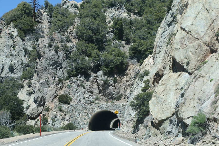
But, the drive itself is awesome. If you're coming-up from Los Angeles, stop at the Shell gas station on Angeles Crest Hwy, that's just south of the 210 Foothill Freeway, and get yourself a one-day U.S. Forest Service Adventure Pass, unless you already have an annual pass or a Golden Age Adventure Pass. The Shell station is the easiest place I've found to get the pass. Hours of the rangers stations are just to variable. Just park and go into the gas station office. It's open 24X7. Do be careful turning into the place if you're coming off the Foothill Fwy and going south on Angeles Crest! That left turn across Angeles Crest can be dicey! It's only $5.00 for a one-day pass and it's needed to legally park within the forest and must be prominently displayed when you park. That includes Mount Wilson. Going-up and coming back, you'll be treated to some of the most awesome views of Los Angeles and the Antelope Valley. That's as far as I've been so far. This could easily be a ½ day if not all day drive. There are several turn-offs and parking areas on the way north. I recommend you take the time to stop on your way north. Using these when going south is way too dangerous between the winding nature of the roads and the absurd speeds many drivers take this road at.
This drive is a must if you like mountain driving and mountain scenery. But, as other reviewers have said: Pay attention to your driving and watch your speed! Note that parts of this drive may be closed in winter due to snow and at any time due to fallen rocks.
Written March 28, 2016
This review is the subjective opinion of a Tripadvisor member and not of Tripadvisor LLC. Tripadvisor performs checks on reviews as part of our industry-leading trust & safety standards. Read our transparency report to learn more.
Jay661
New York City, NY54 contributions
May 2018 • Family
The 66 mile drive from La Cañada Flintridge to Wrightwood is nothing less than spectacular, winding its way back and forth, up and down, through the San Gabriel Mountains. There are scenic stops everywhere, and plenty of places to park, picnic, hike and camp. Highlights include the Mount Wilson Observatory and Newcomb's Ranch Roadhouse. A spectacular drive with lots to do throughout.
Written May 29, 2018
This review is the subjective opinion of a Tripadvisor member and not of Tripadvisor LLC. Tripadvisor performs checks on reviews as part of our industry-leading trust & safety standards. Read our transparency report to learn more.

rendahl
Torrance, CA141 contributions
Jun 2020
The drive from La Canada to Wrightwood is everything the other reviewers are saying. After many years, I convinced my adult children to accompany me on a day-long scenic drive. I don't think they had ever been there, and they seemed enthusiastic for the whole day. My trip was during the Phase 2 opening up of the nation where being outdoors was one of the favorable activities, as long as there were not too many people around.
I will focus on two complaints: the Mt. Wilson Observatory area, and the National Forest Service. This was the last week of June, and things like picnic grounds, take-out cafes, and some buildings were allowed to be open. Mt Wilson has a huge parking lot, a large covered picnic area with rest rooms and a popular snack bar (Cosmic Cafe) that should be open on Saturday and Sunday. The organization that runs the Observatory has chosen to keep everything closed except to walkers. I think they should have opened the parking lot, the rest rooms, and the Cosmic Cafe, at least.
I am angry at the National Forest Service for their callous cruelty in locking up almost all of the rest rooms from La Canada to Wrightwood, with a couple of exceptions. They can close their visitor centers, picnic areas, and campgrounds if they want. But the Sunday I went there were hundreds of cars and motorcycles along the route (with very little traffic). You would think someone there would realize that people need to pee and otherwise use the toilet, and this is not an option. At the Red Box corner, the parking lot was nearly full and the restrooms were locked up tight. The concrete porch into the toilet area was wet and running through the back wall from desperate people heeding nature's call the best way they could. Many other locations along the road had rest rooms but most of them were locked up tight too. Unsanitary. Insulting. I have to give the Forest Service an "F" or one star, damaging the rating of the entire attraction.
Written July 1, 2020
This review is the subjective opinion of a Tripadvisor member and not of Tripadvisor LLC. Tripadvisor performs checks on reviews as part of our industry-leading trust & safety standards. Read our transparency report to learn more.
europeanperson
Pomona, CA2 contributions
Feb 2018 • Solo
IF YOU HAVE A LOWERED CAR, DON'T DRIVE THIS OR TURN AROUND WHEN YOU SEE SNOW. When you start seeing snow, there are generally relatively large rocks on the road. Luckily my lancer GTS isn't dropped and has a relatively high stock height so I was able to barely clear them, but several times I had to swerve into the other lane to avoid the rock slides on the road (thank you no traffic). I encountered this maybe halfway up highway 2, and it seems to be also when 80% of the people dissapear. This route is fun and can be done with those with lowered cars, you just won't go all the way up or you have to finish at La Canada as that way you won't be driving along the rocky sides.
I did this drive all the way from start to end of highway 2 starting at la canada and going up. My mission was simple, speed and get sick photos of my car. Yes roll your eyes at my stupid youthfulness. Anyhow, it seems that going down had a lot more traffic when I went but there are a ton of motorcycles and people with tuner cars taking pictures. The views are absolutely amazing and it's probably the closest you can get to snow either to show your kids for some cute photos or car photos in my case. I highly recommend this drive if you enjoy cars and windy roads!
I did this drive all the way from start to end of highway 2 starting at la canada and going up. My mission was simple, speed and get sick photos of my car. Yes roll your eyes at my stupid youthfulness. Anyhow, it seems that going down had a lot more traffic when I went but there are a ton of motorcycles and people with tuner cars taking pictures. The views are absolutely amazing and it's probably the closest you can get to snow either to show your kids for some cute photos or car photos in my case. I highly recommend this drive if you enjoy cars and windy roads!
Written February 17, 2018
This review is the subjective opinion of a Tripadvisor member and not of Tripadvisor LLC. Tripadvisor performs checks on reviews as part of our industry-leading trust & safety standards. Read our transparency report to learn more.
CarmichaelVentura
California2,604 contributions
Jul 2014
This is not, strictly speaking, an L.A. attraction as it's located in a national park miles away. But it is a wonderful drive with fresh fragrant air, lots of green and great views. Drive carefully.
Written November 7, 2014
This review is the subjective opinion of a Tripadvisor member and not of Tripadvisor LLC. Tripadvisor performs checks on reviews as part of our industry-leading trust & safety standards. Read our transparency report to learn more.
houdini919
2 contributions
Is it RV friendly?

Robert R
Scottsdale, AZ722 contributions
There aren’t any corners or grades that a normal RV couldn’t handle. However, it would be three hours of constant, car sickness-inducing sawing at the wheel to negotiate all of the corners. Unless the driver needs an upper body workout or hates his/her passengers, I’d suggest taking the highways to the south or the wide open roads to the north.
is the road still open (not washed out) between the la canada/ la cresenta area and hesperia


Is this your Tripadvisor listing?
Own or manage this property? Claim your listing for free to respond to reviews, update your profile and much more.
Claim your listingAngeles Crest Highway - All You Need to Know BEFORE You Go (2024)
Frequently Asked Questions about Angeles Crest Highway
- Hotels near Angeles Crest Highway:
- (2.33 mi) Huttopia Paradise Springs
- (2.33 mi) Big Rock Creek Camp
- (8.81 mi) Grand Pine Cabins
- (2.66 mi) Little Jimmy Trail Camp
- (7.81 mi) St. Andrew's Abbey Retreat House
- Restaurants near Angeles Crest Highway:
- (9.09 mi) Grizzly Cafe
- (4.12 mi) Crystal Lake Snack Bar
- (8.88 mi) Blue Ridge Inn
- (8.86 mi) Evergreen Cafe & Racoon Saloon
- (8.86 mi) Village Grind
- Attractions near Angeles Crest Highway:
- (6.73 mi) Ziplines at Pacific Crest
- (5.27 mi) Devil's Punchbowl Natural Area and Nature Center
- (6.20 mi) Bridge To Nowhere
- (8.67 mi) Southern California Soaring Academy
- (3.96 mi) Grassy Hollow Visitor Center