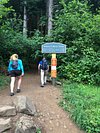
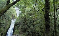
Angels Rest Trail
Angels Rest Trail
4.5

Tours & experiences
Explore different ways to experience this place.
Full view


Top ways to experience Angels Rest Trail and nearby attractions


The area
Best nearby
Restaurants
1 within 3 miles
Attractions
19 within 6 miles


Contribute
Most Recent: Reviews ordered by most recent publish date in descending order.
Detailed Reviews: Reviews ordered by recency and descriptiveness of user-identified themes such as wait time, length of visit, general tips, and location information.
4.5
52 reviews
Excellent
38
Very good
11
Average
3
Poor
0
Terrible
0
alandmich
Tualatin, OR14 contributions
Mar 2019 • Couples
My husband and I are not hikers, but we do enjoy the occasional hike and checking out the scenery. We chose Angels Rest because it was considered "moderate", had a waterfall, and of course the beautiful lookout at the gorge. The trail was much more difficult and crowded than we expected. I think it is usually crowded but with so many trails still closed due to the fire it is probably more crowded than usual. The hike was very pretty and it had a variety of terrain which I like (rocky, dirt, rock covered). I thought it was a difficult hike, not moderate. It was a 1600 ft elevation climb so pretty much uphill going and downhill returning. The rock covered areas were difficult on the feet and calves. I wonder if there were more rocks on the trail than usual due to rock slides with the fire and rains. We were quite sore the few days after the hike. We did make it to the top and the view was beautiful. We packed a light lunch and enjoyed our time at the top. We took about 2 hours to get up and 1 to get down. We did take our time going up and took lots of pictures along the way.
I wouldn't take small children though a lot of people did. Many of them didn't go the whole way up though. If we had our kids with us we would hike to the waterfall and bridge and then turn around. I think our kids would like that part of the hike.
I wouldn't take small children though a lot of people did. Many of them didn't go the whole way up though. If we had our kids with us we would hike to the waterfall and bridge and then turn around. I think our kids would like that part of the hike.
Written April 13, 2019
This review is the subjective opinion of a Tripadvisor member and not of Tripadvisor LLC. Tripadvisor performs checks on reviews as part of our industry-leading trust & safety standards. Read our transparency report to learn more.

Pebble_Daddy
Buda, TX235 contributions
Apr 2017 • Family
Went on this hike with my teenage son. I am in good shape and so is he but we're still d dearly challenged. The trail ranks moderate to difficult depending upon the conditions in my mind. The trail and views are beautiful and the top is stunning. The trial is decently sloped - we gained over 1600 feet in elevation. My phone showed round trip over 6 mile, which took us about 2 hours. The trail condition was super muddy in numerous locations - good hiking shoes are a must this time of year. At the top we saw a healthy wind and rain and at least 10-15 degrees cooler than the start. We came prepared so no issues for us but saw many folks coming up in tank tops and shorts? The trails got a little contested at times. The payoff is worth the effort and plan accordingly.
Written April 2, 2017
This review is the subjective opinion of a Tripadvisor member and not of Tripadvisor LLC. Tripadvisor performs checks on reviews as part of our industry-leading trust & safety standards. Read our transparency report to learn more.

kellerdrake
Portland Oregon31 contributions
Sep 2015 • Couples
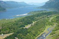
Don't kid yourself if you think you'll have the whole of this 2.2 mile (4.4 mile r/t) hike to yourself. On sunny weekends the trail is more like a line for an amusement park ride, and deservedly so: the view from the top is arguably one of the best views of the North American West you can find within a half-hour of any metropolitan area between the Pacific and the Rocky Mountains. The trail itself is in good condition and features a steady, albeit somewhat steep, hike to the top with very few flat or downhill portions. Folks in good condition age 12 to 60 should be able to get to the top and that spectacular view in 60 - 80 minutes. Wear comfortable shoes, carry water, use your head, don't go off the trail -- there's poison oak up there. My best tip about Angels Rest: go early on a weekday morning.
Written October 7, 2015
This review is the subjective opinion of a Tripadvisor member and not of Tripadvisor LLC. Tripadvisor performs checks on reviews as part of our industry-leading trust & safety standards. Read our transparency report to learn more.
Loree_Harrell
Corbett, OR33 contributions
Jul 2012 • Solo
Having lived here all of my life, I have driven by the large (relatively) parking area at the Angels Rest Trailhead dozens of times, and never really noticed it. In July, King and I packed up early and were the third car in the lot, and started up the hill.
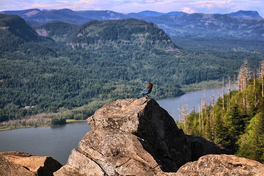
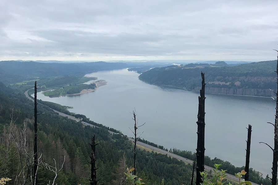
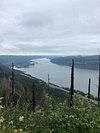
It's an up hike, but, just at the point you're starting to weigh payoff versus pain, the payoff comes in the form of magnificent glimpses of the Columbia River Gorge, and at the top are the most glorious large rock formations and a view to remember forever.
I hiked up to Angels Rest, and crossed over through Wahkeena Springs (sweet spot) to the Wahkeena Falls trail to come back down. The trails are decently marked (take your map anyway as stuff happens), and the only issue was that some idiot neglected to notice that once out at Wahkeena, there was a three mile hike along the Historic Scenic Highway to get back to the van. On a sunny Saturday in July. Very narrow, very busy road, very bad idea - if you're going to do the loop, park a car at both trailheads and take the civilized path back. Otherwise do an up and back. I made it the first two miles and then made the choice for life (actually, King made it - he went down on his belly and refused to continue letting me block him into the nettles) and called a friend to come rescue me.
There are points on the between trail that are going to be marshy when the rains come (if the rains ever come this year), but boot up and you should be fine. Don't recommend this trail if you've been sitting on the couch drinking beer for two years, but if you're in decent shape, you'll love it. Allow four hours for the loop, three for the up and back.
Written October 3, 2012
This review is the subjective opinion of a Tripadvisor member and not of Tripadvisor LLC. Tripadvisor performs checks on reviews as part of our industry-leading trust & safety standards. Read our transparency report to learn more.
Wendy D
Castle Rock, CO17 contributions
Jan 2019 • Family
We went New Years Day as we were passing through Oregon on our way to Seattle. We thought it was a good idea to get out and stretch our legs a bit during the trip. We arrived with cars parked on both sides of two narrow roads stating no parking and violators would be towed. The parking lot holds approximately twelve cars. We waited for a space and shortly received one.
We knew from the cars it would be crowded; however, on most crowded trails people are mindful of each other. Most groups had a least one dog which made an already narrow, muddy then icy path narrower. Most down hikers kept going, pushed past uphill hikers, even going off path instead of pausing. We witnessed several falls due to the frozen mud and lack of courtesy including same direction trails runners knocking people out of the way. Scenery was only okay after all of that. I would not recommend this unless they start monitoring crowds or you can figure out a day that may be light.
We knew from the cars it would be crowded; however, on most crowded trails people are mindful of each other. Most groups had a least one dog which made an already narrow, muddy then icy path narrower. Most down hikers kept going, pushed past uphill hikers, even going off path instead of pausing. We witnessed several falls due to the frozen mud and lack of courtesy including same direction trails runners knocking people out of the way. Scenery was only okay after all of that. I would not recommend this unless they start monitoring crowds or you can figure out a day that may be light.
Written January 3, 2019
This review is the subjective opinion of a Tripadvisor member and not of Tripadvisor LLC. Tripadvisor performs checks on reviews as part of our industry-leading trust & safety standards. Read our transparency report to learn more.

Jenny Singh Mott
Vancouver, WA73 contributions
Nov 2018 • Couples
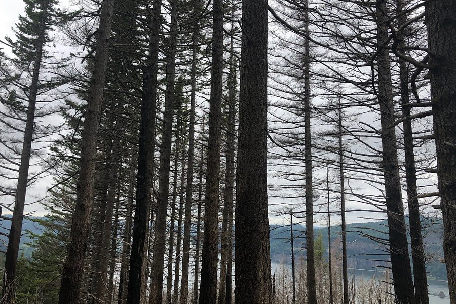
This trail just st re-opened this past weekend Nov 24th,2018. This was one of the trails that was affected by the Eagle Creek fire(2017). The volunteers have done an impeccable job restoring the trails, and other than wind gusts today, we had a great day on the trails👍🏼I am so happy to see life return to our beautiful Gorge.
Written November 27, 2018
This review is the subjective opinion of a Tripadvisor member and not of Tripadvisor LLC. Tripadvisor performs checks on reviews as part of our industry-leading trust & safety standards. Read our transparency report to learn more.

Rebecca_Bee_8
Bristow, VA59 contributions
Aug 2017 • Friends
My mom and I had a great time here! We went with the intention of being at the top at sunset because I friend said that you couldn’t miss it, but we wound up leaving early. It seemed like it would be dangerous to walk down in the dark because there are a few places that are exposed to a drop off. The hike itself was pretty easy for me, but my mom had to go a little slower. When you reach the top pay attention! We walked right past the lookout and started walking in the “devil’s rest” trail, which is a continuation. It is much narrower, so you will probably be able to tell if you go to far.
Written February 8, 2018
This review is the subjective opinion of a Tripadvisor member and not of Tripadvisor LLC. Tripadvisor performs checks on reviews as part of our industry-leading trust & safety standards. Read our transparency report to learn more.

karen b
Pittsburgh, PA500 contributions
Jul 2017 • Couples
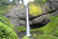
Along the water fall loop hike or can drive there and park then a short walk to fall. Really pretty and worth the stop
Written November 26, 2017
This review is the subjective opinion of a Tripadvisor member and not of Tripadvisor LLC. Tripadvisor performs checks on reviews as part of our industry-leading trust & safety standards. Read our transparency report to learn more.
Jiro_Shiba
95 contributions
May 2017 • Solo
"Woohoo! As good as it gets!" Approximately 30 minutes away from downtown Portland is this beautiful place in the Columbia River Gorge area. This short 4.1 mile hike would probably be considered a moderate hike with a good amount of incline but nothing too crazy steep. Lots and lots of people but I can see why this place is so popular.....because it's absolutely BEAUTIFUL!! The hike is mostly shaded around the 1st half or so and the trail was relatively muddy with some slippery rocks (nothing too bad though). If you have about 2 hours to spare from your day and don't mind getting sweaty, do this hike! You will not regret it! Spectacular view of the gorge at the summit and you will get there relatively quick! There is a rocky section a little before the summit that opens up and kind of makes you feel like you've reached the summit, but keep going and the trail actually continues. At the summit, you will see large rocks where you can scramble up and find that perfect spot to enjoy the perfect view with the perfect snack.
I was in a bit of a rush this day but really wanted to conquer this hike before I head back to California...and I'm really glad I did it! It took me about a total of 1 hour 30 minutes for this hike with 20 minutes for pictures, rock scrambling and staring at the view. I did have to run down with my hiking boots & day pack (almost fell several times although I'm a trail runner....don't recommend running with hiking boots & a day pack) since I was short on time so it may take longer if walking down. You can make this hike longer by going to Devil's Rest. I shall conquer that one next time.
Forest pass is not required to park. The lot is quite small and parking can be difficult due to the popularity. There was a sign that said restrooms are available 0.4 miles away from the Angel's Rest trailhead. Total elevation gain is 1,490 feet.
Written May 23, 2017
This review is the subjective opinion of a Tripadvisor member and not of Tripadvisor LLC. Tripadvisor performs checks on reviews as part of our industry-leading trust & safety standards. Read our transparency report to learn more.

KarenH302
Montville, NJ236 contributions
Sep 2016 • Friends
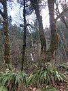
What an amazing hike. We hiked from Wahkeena Falls to Fairy Falls. The beginning of the hike is paved switchbacks, which get a little boring. Once you reach the top, there is an overlook over the valley. The well maintained trail continues past flowing streams and moss covered trees. Print a trail map out ahead of time from the website. I believe the incline is about 100 feet but it is gradual. Go at your own pace and the views are definitely worth it.
Written October 30, 2016
This review is the subjective opinion of a Tripadvisor member and not of Tripadvisor LLC. Tripadvisor performs checks on reviews as part of our industry-leading trust & safety standards. Read our transparency report to learn more.
No questions have been asked about this experience
Is this your Tripadvisor listing?
Own or manage this property? Claim your listing for free to respond to reviews, update your profile and much more.
Claim your listingAngels Rest Trail - All You Need to Know BEFORE You Go (2024)
Frequently Asked Questions about Angels Rest Trail
- Hotels near Angels Rest Trail:
- (0.70 mi) Bridal Veil Lodge
- (1.98 mi) Ainsworth State Park
- (4.05 mi) Quiet waterfront cabin on an acre lot with private hot tub & river access
- (5.60 mi) Angels Rest Bed & Breakfast Lavender Farm
- (5.67 mi) Huge home on 10 acres with Hot tub/Sauna & Privacy
- Restaurants near Angels Rest Trail:
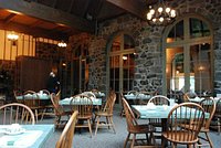
- (2.94 mi) Multnomah Falls Lodge Restaurant
- (9.67 mi) K&M Drive In
- (9.70 mi) Riverview Restaurant
- (7.49 mi) 54°40′ Brewing Company
- (5.77 mi) Corbett Country Market