Visayas
The Visayas are a major island and cultural grouping in the midsection of the Philippines. Nearly every part of the region has some fine beaches along its coasts, some fine diving areas including many coral reefs teeming with life, and some interesting historic buildings, mostly from the Spanish colonial period, in the cities and some towns.| Tap on the map to travel |
Popular Destinations
Dumaguete

Photo: MarionPaulBaylado, CC BY-SA 3.0.
Dumaguete is the capital city and main port of Negros Oriental, the province that occupies the south-eastern part of Negros Island, in the Philippines.
Bacolod

Photo: Pbsouthwood, CC BY-SA 3.0.
Bacolod is the capital of the province of Negros Occidental in the Philippines, and the most populous city on Negros Island at about 600,000 in the 2020 census.
Boracay
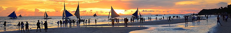
Photo: EzykronHD, CC BY-SA 3.0.
Boracay is a tropical island about an hour's flight from Metro Manila in the Philippines.
Destinations
Cebu Province
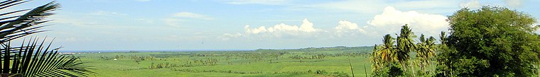
Photo: Matt Kieffer, CC BY-SA 2.0.
Cebu Island is a large island in the Visayas region of the Philippines.
Negros

Photo: Princeofmagatas, CC BY-SA 4.0.
Negros is a large island in the Visayas, the island group that forms roughly the central third of the Philippines.


Samar Island
 Samar is the third largest island in the Philippines, after Mindanao and Luzon islands.
Bohol

Photo: Jjtkk, CC BY-SA 3.0.
Bohol is the main island of Bohol Province, which also includes 75 smaller islands.
Western Visayas
 Western Visayas is an administrative region in the Visayas island group in the Philippines.
Central Visayas
 The Central Visayas is one of the administrative regions of the Philippines, part of the Visayas island group.
Siquijor
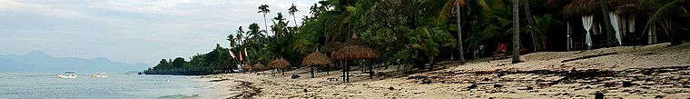
Photo: Renzelle Mae Abasolo, CC BY 2.0.
Siquijor is a small island province in the Visayas lying some 22 km east of Southern Negros.
Eastern Visayas
 Eastern Visayas is one of the three administrative regions in the Visayas group of islands, and is designated Region VIII out of the 17 regions of the entire Philippines.
Biliran

Photo: marge bagsic, CC BY 2.0.
Biliran, officially the Province of Biliran, is an island province in the Philippines located in the Eastern Visayas region.
Visayas
- Type: Island with 14,800 residents
- Description: one of the three island groups of the Philippines
- Categories: island group of the Philippines, statistical territorial entity and locality
- Location: Municipality of Santo Tomas, Davao del Norte, Davao Region, Mindanao, Philippines, Southeast Asia, Asia
- View on OpenStreetMap
Latitude of center
11° northLongitude of center
123.5° or 123° 30' eastPopulation
14,800Elevation
43 metres (141 feet)OpenStreetMap ID
node 302033096OpenStreetMap Feature
place=islandGeoNames ID
1697736Wikidata ID
Q211436Visayas Satellite Map
© OpenStreetMap, Mapbox and Maxar
Also Known As
- Afrikaans: Visayas
- Arabic: Kabisay-an
- Arabic: بيسايا
- Armenian: Վիսարյան կղզիներ
- Asturian: Visayas
- Azerbaijani: Visay adaları
- Basque: Bisayak
- Belarusian: Вісайскія астравы
- Breton: Visayas
- Catalan: Visayas
- Cebuano: Kabisay-an
- Cebuano: Kabisay·an
- Central Bikol: Visayas
- Chavacano: Arcipiélago Bisayo
- Chavacano: Bisayas
- Chinese: 米沙鄢群岛
- Chinese: 米沙鄢群島
- Chinese: 維薩亞斯群島
- Croatian: Visayas
- Czech: Visayské ostrovy
- Danish: Visayas
- Dutch: Visayas
- English: Visayan Islands
- English: Visayas island group
- Esperanto: Bisajoj
- Estonian: Visayani saared
- Filipino: New Visayas
- Finnish: Visayas
- French: Visayas
- Galician: Visayas
- Georgian: ვისაიასი
- German: Visayas
- Greek: Βισάγιας
- Hakka Chinese: Mí-sâ-yên Khiùn-tó
- Hausa: Visayas Khiùn-tó
- Hebrew: ויסאיאס
- Hindi: विसाया
- Hungarian: Visayan-szigetek
- Hungarian: Viszajan-szigetek
- Iloko: Visayas
- Indonesian: Visayas
- Indonesian: kelompok pulau Visayas
- Indonesian: kepulauan Visayas
- Italian: Arcipelago Bissaio
- Italian: Bissaie
- Italian: Isoli Bissaie
- Japanese: ビサヤ諸島
- Japanese: ヴィサヤ
- Japanese: ヴィサヤ諸島
- Kinaray-A: Kabisay-an
- Kinaray-A: Kabisay·an
- Korean: 비사야스 제도
- Lao: Visayas
- Latin: Bisaiana
- Latin: Bisaianae insulae
- Latin: Bisajana
- Latin: Bisajanae insulae
- Latin: insulae Bisaianae
- Latin: insulae Bisajanae
- Latvian: Visaju salas
- Lithuanian: Visajų salynas
- Macedonian: Висајски Острови
- Malagasy: Bisayas
- Malay: Bisayak
- Malay: Visayas
- Marathi: विसायस
- Northern Frisian: Visayas
- Norwegian: Visayas
- Norwegian Bokmål: Visayas
- Norwegian Nynorsk: Visayaøyane
- Ossetian: Висайтæ
- Pampanga: Kabisayan
- Pampanga: Visayas
- Persian: ویسایا
- Polish: Visayas
- Portuguese: Visayas
- Portuguese: Vissaias
- Romanian: Visayas
- Russian: Висайские острова
- Serbian: Висајска острва
- Slovak: Visayské ostrovy
- Slovenian: Visaje
- Spanish: Arcipiélago Bisayo
- Spanish: Bisayas
- Spanish: Islas Bisayas
- Swedish: Visayas
- Swedish: Visayaöarna
- Tagalog: Bisayas
- Tagalog: Kabisayaan
- Tagalog: Visayas
- Tagalog: kapuluan ng Bisayas
- Tagalog: kapuluan ng Visayas
- Tamil: விசயன் தீவுகள்
- Tatar: Висай утраулары
- Thai: วิซายัส
- Turkish: Visayalar
- Turkish: Visayas
- Ukrainian: Вісайські острови
- Urdu: ویسایا
- Venetian: Bisaje
- Vietnamese: Visayas
- Waray (Philippines): Kabisay-an
- Wu Chinese: 米沙鄢群岛
- Yue Chinese: 維薩亞斯群島
- 비사야 제도
Escape to a Random Place
About Mapcarta. Thanks to Mapbox for providing amazing maps. Data © OpenStreetMap contributors and available under the Open Database License. Text is available under the CC BY-SA 4.0 license, excluding photos, directions and the map. Description text is based on the Wikivoyage page Visayas. Photo: Wikimedia, CC0.