
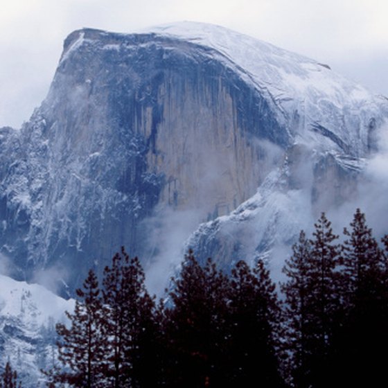
Half Dome is one of the most famous landforms in Yosemite Valley. (Photo: Medioimages/Photodisc/Photodisc/Getty Images )
A landform is a naturally occurring feature on the surface of the earth. California’s landforms are as varied as its multi-cultural population. Some have survived without alteration; others have been tweaked by the hand of man but still remain suitably impressive. The most famous of California’s landforms grace postcards, enhance tourism websites and offer tantalizing invitations to visit the Golden State.
San Francisco Bay
When Gaspar de Portola got his first look at San Francisco Bay from the top of Sweeney Ridge in what is now Pacifica, he saw one of the largest natural harbors on the planet. Back in 1769, the Golden Gate Bridge did not exist, nor the elegant San Francisco skyline. What Portola saw was a huge body of water surrounded by hills, beaches and marshes. This California landform perhaps is most famous for its golden bridge and the infamous Alcatraz Island, yet take away the trappings of civilization, and California is left with an impressive waterway leading out into the Pacific Ocean, not to mention numerous places to do a bit of fishing.
Yosemite Half Dome
Looking a bit like half an ice cream scoop awaiting the next bite, Half Dome is an iconic landform in Yosemite National Park. At one time the mountain, with its near vertical granite face, was considered inaccessible. Yet today it is one of the most challenging climbs in the park. Those who make it to the top of the near 5,000-foot high landform are rewarded with a view of Yosemite Valley and a good portion of the Sierra Mountains. The park service has laid out trails and installed cables to help climbers reach the summit. Other than that, Half Dome remains in its natural state.
Death Valley
Death Valley is a place of extremes. In summer, temperatures can get above 120 degrees Fahrenheit and stay there. During the winter, mountains rimming the canyon can have a dusting of snow on their peaks. Death Valley was created by the shifting of the earth’s crust in earthquake-prone California. At 282 feet below sea level, Death Valley is the lowest bit of land in North America. It sits between two mountain ranges, the Panamint Range to the west and the Amargosa Range on the valley’s east end. Borax commercials featuring the legendary 20 mule teams that hauled the raw borax ore across this desert made Death Valley a well-known name. Today, Death Valley National Park attracts visitors wanting to explore this challenging environment. Sand dunes, salt flats and Salt Creek, home to the endangered pupfish, are all part of the experience.
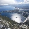
Lake Tahoe
California shares Lake Tahoe, located in the Sierra Nevada mountains, with the state of Nevada, but two-thirds of the lake is inside the California border. Created by active fault lines, the lake’s surface sits 6,225 feet above sea level. The surrounding mountains have peaks that reach some 10,000 feet in height. At a maximum depth of 1,645 feet, Lake Tahoe is considered one of the United States' deepest lakes. In winter skiers flock to the various ski-hills that rim the lake. During the summer, camping, boating and fishing are the big attractions. Of course, the Nevada side offers year-round gambling, which is illegal on the California side of the lake.
References
Resources
Writer Bio
Monica Wachman is a former editor and writer for FishersTravelSOS, EasyRez.com and Bonsai Ireland. She has an AA degree in travel from Career Com Technical and is an avid RV buff and gardener. In 2014, she published "Mouschie and the Big White Box" about an RV trip across North America.