Sundance Resort
Last updated| Sundance Resort | |
|---|---|
 Sundance in the fall | |
 Sundance Resort Location in Utah  Sundance Resort Sundance Resort (the United States) | |
| Location | Uinta National Forest Utah County, Utah |
| Nearest major city | Provo - 13 miles (21 km) |
| Coordinates | 40°23′31″N111°34′44″W / 40.392°N 111.579°W |
| Vertical | 2,150 ft (655 m) |
| Top elevation | 8,250 ft (2,515 m) |
| Base elevation | 6,100 ft (1,859 m) |
| Skiable area | 450 acres (1.8 km2) |
| Trails | 44 |
| Lift system | 5 chairlifts (1 high speed quad, 3 fixed-grip quads, 1 triple) 1 handle tow |
| Terrain parks | 2 intermediate/advance- beginner |
| Night skiing | limited |
| Website | sundanceresort.com |
Sundance Resort, also known as Sundance Mountain Resort, is a ski resort located 13 miles (21 km) northeast of Provo, Utah. It includes more than 5,000 acres (2,000 ha) on the slopes of Mount Timpanogos in Utah's Wasatch Range. Alpine skiing began on the site in 1944. Actor Robert Redford acquired the area in 1968, [1] [2] [3] and established a year-round resort that would later spawn the independent Sundance Film Festival and the non-profit Sundance Institute. The resort was first listed as a census-designated place (CDP) before the 2020 census. [4]
Contents
History
The area known today as the Sundance Resort in the North Fork canyon was surveyed in the mid-1800s by Andrew Jackson Stewart Jr. and his sons, Andrew, Scott, and John Stewart. While working for the U.S. government, they discovered the view of Mt. Timpanogos. They each received 160 acres of land under the Homestead Act, and nearby lots were given to family members. Soon, members of the Stewart family erected log cabins. By 1911, they owned 2,200 acres and were raising sheep and cattle. They formed a company, North Folk Investment Co., to share income and protect the land. The area was known as "Stewart Flats" after the large number of Stewart family members living in the area. [5] : 1
Until 1920, "Stewart Flats" was connected to the wider world by a single unpaved road with a grade of 18 to 20 degrees on the last half mile. It was referred to as the "big dugway" due to the trench formed from dragging large trees down the road. In the early 1920s, the Utah County Commission built an automobile road that passed through "Stewart Falls" as it connected the towns of Aspen Grove and Wildwood. [5] : 9–12
Hiking trails
Mount Timpanogos became a popular mountain to hike after 1912, when Eugene L. Roberts, a professor at Brigham Young University opened a hiking trail and began taking students. [6] The Timpanogos Hike began after mid-July when there was a full moon. The night before the hike, participants would gather for a celebration that usually had a bonfire. A favorite part of the celebration was the enactment of the "Legend of Timpanogos" that tells the story of an Indian princess who falls in love with a soldier who goes off to war; the soldier did not return, but she watched and waited for him atop Mount Timpanogos until she died. [5] : 25 Roberts' event spawned an annual Timpanogos Hike.
In 1922, the Forest Service over the Wasatch National Forest, part of the United States Department of Agriculture, requested to put in a trail that crossed part of the property owned by the North Folk Investment Co, [7] The Stewart family appreciated the hikes since they brought more popularity to the area. [5] : 26 Today, the trails around the Sundance Mountain Resort offer views of North Fork, Utah and of Stewart Falls. Many trails also feature plaques to mark flora and fauna in the area and are lined with benches. [8] There are also three major biking trails at Sundance that even have ski-lift service after Memorial Day weekend. [9]

Timp Haven
Ski races began on the Mount Timpanogos Glacier during the annual Timp hike in July 1941. The race was a slalom race. This race would be held three more times in 1947, 1948, and 1949. A ski area later opened as Timp Haven in 1944. [10] The name was chosen by a contest in which anyone could submit their suggestion. Ruth Biddulph submitted the winning name of Timp Haven and was given a season pass. [11] Timp Haven was owned by S. Paul Stewart and run with the help of his brother Ray Stewart for over twenty years. [10] Paul managed the slopes, built the ski lodge, and installed the water system. Ray Stewart was responsible for clearing and developing the Timp Haven Ski Resort and contributed to the original rope tow used. Hilda Stewart, Paul's wife, had a cafe on the resort property and served hamburgers and other meals to ski guests. Paul later purchased the interests of other members of the Stewart family, which altogether owned between 3,000 and 4,000 acres of the property. [8] The investment in the land in North Fork never paid dividends for the North Fork Investment Company owners. [5] : 32

The resort had a rope tow [10] that was built by J.W. Daniel, who had tried to make a tow in Hobble Creek Canyon near Springville, Utah. The tow was powered by a Chevrolet truck, but was unsuccessful in that area. The Timpanogos Mountain Club persuaded Daniel to bring the tow to North Fork Canton. The tow was not ready for winter of 1944, and so it was abandoned by the club. Ray Stewart bought the truck and equipment and overhauled it to create a working tow to run on Saturdays and Sundays. The tow was difficult to use, however, because some of the roads leading to the resort were not plowed regularly making it difficult to drive the truck, and cold mornings caused the vehicle to freeze over. The tow pulled skiers 500 feet up the mountain. In addition, When Timp Haven opened, the creek was closer to the hill than it is today, so skiers had to make a quick turn at the bottom to avoid falling into the water. Ski season at Timp Haven started around Christmas and lasted until early March. A day pass to ski was only $1, and due to lighting installed by Provo City, Timp Haven allowed night skiing on Mondays, Wednesdays, and Fridays. [11] While owned by the Stewart family, the ski area was closed on Sundays. [12] Timp Haven also held ski races that were sponsored by various local organizations like the Timpanogos Ski Club or the Hoover Cup. [11] The Timponogos Mountain Club cleared an area on the east hill and built a 45-foot ski jump. [13]
Ski classes at the resort were started by Jessie Scofield, the supervisor of Provo City Recreation, in the winter of 1946. Professors at Brigham Young University also started ski classes, bringing buses of students in the afternoons. By that time, Timp Haven also had a tubing and toboggan hill. The Stewart family began expansion in 1947, and a T-bar lift was added at the base in 1948 (the same year as the ski jump was rebuilt) [11] which was about 1,000 feet (300 m) in length, [10] The lower terminal was seated on a platform that was 14 feet in the air. A 1938 Ford truck provided the power for the lift. This lift ran until 1953 when [14] a single chairlift was added in the fall. It had a length of about 2,500 feet (760 m). [15] [16] The first double chairlift was installed in the fall of 1965 and replaced the lower single chair and an upper T-bar, vertically climbing 1,400 feet (430 m). [17] It had an accident the following July which resulted in two fatalities. [18] The resort continued expanding, however, and a lodge was built in 1957 (whose foundation is under the General Store and Grill Room today). A poma lift was added in 1958. A modern ski lift, the Mandan, was installed in 1964 and the two T-bar lifts were removed. The Navajo lift was installed in 1969, and the Arrowhead lift in 1985. [19]
Ownership under Robert Redford
The Stewart family built a subdivision on "Stewart Flats" in the 1960s called Timp Haven Homes. Robert Redford purchased a 2-acre lot. [5] : 48 Later, in August 1968, Redford purchased the entirety of Timp Haven, the land that is now known as Sundance, [2] [20] [21] : 11 The resort was renamed from Timp Haven to Sundance, after the role Redford played in the 1969 film Butch Cassidy and the Sundance Kid . [20] The resort of Sundance is not to be confused with the town of Sundance, Wyoming, the location from which the Sundance Kid received his name. Redford's 1972 film Jeremiah Johnson was filmed near the resort. [22]
Because of its lower elevation, the resort had a shorter ski season than its competitors. In order to increase revenue, Redford wanted to create an Aspen-like atmosphere and use the resort to promote the arts and draw in Hollywood stars. The Sundance Film Festival was held at the resort to help it achieve this purpose. [21] : 11
Sundance Institute and Film Festival
In November 1979, Redford held a 3-day conference for filmmakers and professional artists at the Sundance Mountain Resort. The goal of the event was to promote indie filmmakers. These efforts laid the foundation for what would become the Sundance Institute. [21] : 8–13 In 1981, the Sundance Institute was founded to foster and celebrate the diversity of American filmmaking. [23]

In 1985, the Sundance Institute took over operations of the United States Film Festival. The organization had been founded in 1978, however, it became a part of Sundance, and in 1989 the name was officially changed to the Sundance Film Festival. [24] : 3 In 1985 Redford hosted the first film festival at Sundance to promote independent films. [25] Redford initially objected to taking over the film festival, and in its early years it was "regarded by many [film] distributors as toxic". [21] : 29 In 1989, however, the film festival gained recognition after its showing of Sex, Lies, and Videotape by Steven Soderbergh. That was the year the festival began to achieve its goal of shaping independent film making. Although it has increased in popularity, the film festival has maintained its support of the making and distribution of indie films. [24] : 3–5
Today, the Sundance Film Festival is held each year in January and primarily 30 miles (50 km) north in Park City, and is a popular and well-known competition for independent film makers. It is the largest independent film festival in the United States, and also one of the largest in the world. It features documentaries, large films and small films. The festival receives over 9,000 submissions, and around 200 are featured. More than 50,000 people attend the festival each year. [26]
The small town that surrounds the resort is home to 28 full-time residents, with many residents living in the area more than 50 years.[ citation needed ] Several notable people have owned residencies in the Sundance Resort properties, including Sydney Pollack, William Devane, and Daniel Melnick. [8]
New ownership
Robert Redford reached an agreement to sell the 2,600-acre resort to Broadreach Capital Partners and Cedar Capital Partners. He announced the sale [27] to employees on December 11, 2020.
Though the resort has been Redford's Utah home for more than a half-century, it also "created a lot of weight for me to be carrying around", Redford told the Salt Lake Tribune [27] in December 2020, ahead of the announcement of the sale. "I had been searching for years for the right people to take it to the next level, so that I could take that weight off my shoulders and enjoy my life".
As part of the sale, Broadreach and Cedar have committed to continue Redford's policies of responsible development and land preservation. The resort's 2,600 acres include 1,845 acres that are preserved through a conservation easement and protective covenants.
Climate
| Climate data for Sundance, Utah, 1991–2020 normals, 1997-2007 precip/snow: 6620ft (2018m) | |||||||||||||
|---|---|---|---|---|---|---|---|---|---|---|---|---|---|
| Month | Jan | Feb | Mar | Apr | May | Jun | Jul | Aug | Sep | Oct | Nov | Dec | Year |
| Mean daily maximum °F (°C) | 31.5 (−0.3) | 33.4 (0.8) | 41.8 (5.4) | 49.4 (9.7) | 61.7 (16.5) | 73.2 (22.9) | 80.8 (27.1) | 79.5 (26.4) | 67.7 (19.8) | 52.8 (11.6) | 40.2 (4.6) | 30.9 (−0.6) | 53.6 (12.0) |
| Daily mean °F (°C) | 25.3 (−3.7) | 26.9 (−2.8) | 34.1 (1.2) | 40.6 (4.8) | 51.0 (10.6) | 61.2 (16.2) | 69.2 (20.7) | 68.0 (20.0) | 57.2 (14.0) | 44.4 (6.9) | 33.4 (0.8) | 24.8 (−4.0) | 44.7 (7.1) |
| Mean daily minimum °F (°C) | 19.2 (−7.1) | 20.4 (−6.4) | 26.4 (−3.1) | 31.7 (−0.2) | 40.2 (4.6) | 49.3 (9.6) | 57.6 (14.2) | 56.4 (13.6) | 46.7 (8.2) | 36.0 (2.2) | 26.5 (−3.1) | 18.6 (−7.4) | 35.8 (2.1) |
| Average precipitation inches (mm) | 6.76 (172) | 4.62 (117) | 3.19 (81) | 3.96 (101) | 2.94 (75) | 2.17 (55) | 0.83 (21) | 1.63 (41) | 2.01 (51) | 3.34 (85) | 3.44 (87) | 4.98 (126) | 39.87 (1,012) |
| Average snowfall inches (cm) | 40.60 (103.1) | 38.10 (96.8) | 25.90 (65.8) | 16.20 (41.1) | 2.90 (7.4) | 0.00 (0.00) | 0.00 (0.00) | 0.00 (0.00) | 0.20 (0.51) | 3.20 (8.1) | 19.70 (50.0) | 41.60 (105.7) | 188.4 (478.51) |
| Source 1: NOAA [28] | |||||||||||||
| Source 2: XMACIS2 (precipitation & snowfall) [29] | |||||||||||||
Recent developments
Skiing trails

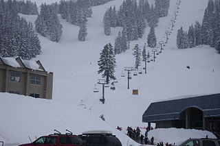
Today, Sundance Mountain Resort has skiing for every ability, with 20% beginner trails, 40% intermediate trails and 40% advanced trails. The resort terrain climbs 2,150 vertical feet (655 m) up the northeast slope of Mount Timpanogos, reaching the crest of the ridge at Bearclaw Cabin. This restaurant at the resort's apex of 8,250 feet (2,515 m) provides spectacular 360° views of the surrounding landscape, and of Mount Timpanogos as it rises to a height just short of 12,000 ft (3,660 m). [30]
Chairlifts
In 1994, CTEC constructed a fixed-grip quad named Ray's, to honor Ray Stewart and his work in developing Timp Haven. The lift offered direct access to the back of the mountain and covered over 5,400 feet with a vertical rise of 1,400 feet, with an uphill capacity of 1,800 people per hour. [31]
The mountain is serviced by four chairlifts and a handle tow for beginners at the mountain's base.[ citation needed ] Sundance now offers the 6th longest zip line in the United States, which features the most vertical drop of any zip line on the North American Continent. [32]
In 2016, the Arrowhead triple was retired and replaced with a fixed-grip quad, constructed by Doppelmayr USA. The new lift was named Red's, after Redford and his family, and carried 500 more people uphill per hour over its predecessor.
For the 2021-2022 season, Doppelmayr USA constructed two chairlifts to replace the aging Ray's lift. The front side portion was replaced by a high speed quad, known as the Outlaw Express, running on an alignment previously used by the Mandan double chairlift that Ray's replaced, with a mid-unload station below Marmot Gulch to service beginner terrain that had been accessible from the winter mid-station on Ray's. The backside portion was replaced with a new fixed grip quad called Stairway, running from the bottom of Red's to the Mandan summit.
Related Research Articles

Mount Timpanogos, often referred to as Timp, is the second-highest mountain in Utah's Wasatch Range. Timpanogos rises to an elevation of 11,752 ft (3,582 m) above sea level in the Uinta-Wasatch-Cache National Forest. With 5,270 ft (1,610 m) of topographic prominence, Timpanogos is the 47th-most prominent mountain in the contiguous United States.
Alta is a ski area in the western United States, located in the town of Alta in the Wasatch Mountains of Utah, in Salt Lake County. With a skiable area of 2,614 acres (10.58 km2), Alta's base elevation is 8,530 ft (2,600 m) and rises to 11,068 ft (3,374 m) for a vertical gain of 2,538 ft (774 m). One of the oldest ski resorts in the country, it opened its first lift in early 1939. Alta is known for receiving more snow than most Utah resorts, with an average annual snowfall of 545 inches (13.8 m). It is also regularly ranked as having the best snow in North America. Alta is one of three remaining ski resorts in the U.S. that prohibits snowboarders, along with nearby competitor Deer Valley and Vermont's Mad River Glen.
Silver Star Mountain Resort is a ski resort located near Silver Star Provincial Park in the Shuswap Highland of the Monashee Mountains, 22 km northeast of the city of Vernon, British Columbia, Canada. Silver Star's snow season runs from late November to mid-April, weather permitting. Silver Star provides summer lift access for mountain biking and hiking from the end of June through September.

Snowbasin Resort is a ski resort in the western United States, located in Weber County, Utah, 33 miles (53 km) northeast of Salt Lake City, on the back (east) side of the Wasatch Range.

Bogus Basin Mountain Recreation Area is a ski area in Boise County, Idaho, sixteen road miles (26 km) north-northeast of the city of Boise.
Powder Mountain is a ski resort east of Eden, Utah, stretching between Weber and Cache counties and 55 miles (89 km) from Salt Lake City International Airport. Covering 8,464 acres, Powder Mountain is the largest ski resort in the US by skiable acreage. The resort has 154 trails, nine lifts, and two terrain parks.
Mount Bachelor ski resort is a ski resort located in Central Oregon, approximately 22 miles (35 km) west of Bend, along Century Drive Highway. The ski area is on the northern side of Mount Bachelor, a stratovolcano rising atop a volcanic shield in the Cascade Range.

Copper Mountain is a mountain and ski resort located in Summit County, Colorado, about 75 miles (120 km) west of Denver on Interstate 70. The resort has 2,465 acres of in-bounds terrain under lease from the U.S. Forest Service, White River National Forest, Dillon Ranger District. It is operated by POWDR.

Solitude Mountain Resort is a ski resort located in the Big Cottonwood Canyon of the Wasatch Mountains, thirty miles southeast of Salt Lake City, Utah. With 66 trails, 1,200 acres (4.9 km2) and 2,047 feet (624 m) vertical, Solitude is one of the smaller ski resorts near Salt Lake City, along with its neighbor Brighton. It is a family-oriented mountain, with a wider range of beginner and intermediate slopes than other nearby ski resorts; 50% of its slopes are graded "beginner" or "intermediate," the highest such ratio in the Salt Lake City area. Solitude was one of the first major US resorts to adopt an RFID lift ticket system, allowing lift lines to move more efficiently. It was followed by Alta Ski Area in 2007. Solitude is adjacent to Brighton Ski Resort near the top of Big Cottonwood Canyon. Solitude and Brighton offer a common "Solbright Pass" which provides access to both resorts for a nominal surcharge.
Brian Head Ski Resort is a ski destination for Southern Utah and the southern California, Arizona, and Las Vegas areas. It is located 3.5 hours north of Las Vegas and four hours south of Salt Lake City. The resort is Utah's southernmost. Brian Head Resort was established in 1964, and once operated as a one chairlift resort. Currently, the resort has 8 chairlifts, 71 runs, and over 650 skiable acres. It also features a bridge between its two skiable mountains, Navajo Peak and Brian Head. A free town shuttle can transport you around the town and resort for no cost.

Park City Mountain Resort (PCMR) is a ski resort in the western United States in Park City, Utah, located 32 miles (51 km) east of Salt Lake City. Park City, as the ski resort and area is known, contains several training courses for the U.S. Ski Team, including slalom and giant slalom runs. During the 2002 Winter Olympics, it hosted the snowboarding events and the men's and women's alpine giant slalom events.

The Summit at Snoqualmie is a recreation area in the northwest United States, located on Snoqualmie Pass, Washington. It provides alpine skiing and snowboarding, Nordic skiing, mountain biking, winter tubing, and scenic lift rides. Owned and managed by Boyne Resorts, it is 52 miles (80 km) east of downtown Seattle on Interstate 90.
Vail Ski Resort is a ski resort in the western United States, located near the town of Vail in Eagle County, Colorado. At 5,289 acres, it is the third-largest single-mountain ski resort in the U.S., behind Big Sky and Park City, featuring seven bowls and intermediate gladed terrain in Blue Sky Basin.

American Fork Canyon is a canyon in the Wasatch Mountains of Utah, United States. The canyon is famous for the Timpanogos Cave National Monument, which resides on its south side. It is named after the American Fork River, which runs through the bottom of the canyon.

Seven Springs Mountain Resort is an all-season resort located in the borough of Seven Springs, Pennsylvania. It has a relatively high elevation for a Pennsylvania ski area, at 3,001 feet (915 m) above sea level. Activities include biking, canopy touring, ziplining, sporting clays, fishing, hiking and golfing in the summer and skiing, snowboarding and snow tubing in the winter. The ski season at Seven Springs typically begins on the day after Thanksgiving and continues to mid-April, weather permitting.

State Route 92 (SR-92), also known in various portions as the Timpanogos Highway, and Alpine Loop Scenic Highway is a scenic state highway in Utah County, Utah that runs from I-15/US-89 in Lehi to US-189 in Provo Canyon. The route is 27.296 miles (43.929 km) long and is the only road with access to Sundance Ski Resort and the Aspen Grove Family Camp and Conference Center.

Snow King Mountain is a summer and winter resort in the western United States, in Jackson, Wyoming. The mountain is Jackson's original 1936 ski hill, located on the southeast edge of the city, and was the first ski area in Wyoming. Locals sometimes refer to Snow King as "The Town Hill," and it offers skiing, hiking, an alpine slide, and many other attractions. The ski season runs from December to late March, and has a summer season that runs from June to October. Skiing is offered after the closure of lifts, until the snow is gone thanks to a boot pack trail on the west side of the resorts Runs. Hiking trails are offered all over the mountain.

Provo Canyon is located in unincorporated Utah County and Wasatch County, Utah. Provo Canyon runs between Mount Timpanogos on the north and Mount Cascade on the south. The canyon extends from Orem on the west end to Heber City on the east. Provo Canyon is situated to the east of Utah Valley and grants access to the valleys and Uinta Basin regions that lie beyond the Wasatch front.
Junior Bounous has been known as a "Pioneer in the American Ski Industry" and has been skiing the Wasatch Mountains and elsewhere for over 80 years. He is known for his ski accomplishments and teaching.

The Mount Timpanogos Transit Center was a staffed, open air bus transfer station in southeast Orem, Utah, United States. It functioned as both the Utah Transit Authority's (UTA) customer service center for Utah County, as well as a bus transfer center for UTA's buses in east central Utah Valley. Prior to the opening of the FrontRunner commuter rail extension south to Provo in 2012), it was the busiest bus stop within the entire UTA bus system.
References
- ↑ Pearson, Howard (August 3, 1968). "Star, wife set up Utah businesses". Deseret News. p. 2B.
- 1 2 "Slope manicure for Timp Haven". Deseret News. August 31, 1968. p. B1.
- ↑ "Sundance Village and Ski Resort". Utah.com. Retrieved February 8, 2009.
- ↑ "Sundance Census Designated Place". Geographic Names Information System . United States Geological Survey, United States Department of the Interior.
- 1 2 3 4 5 6 Stewart, Justin (1987). A history of Sundance, Utah.
- ↑ Carter, Edward L. (July 14, 1997). "Timp path began hike to popularity 85 years ago". Deseret News.
- ↑ Dana, Parkinson (March 27, 1876), "United States Department of Agriculture Letter", in Anderson, Barbara Stewart (ed.), Early Mormon Documents, vol. 1, Raymond R. Stewart (published 2005), ISBN 1-58308-398-7
- 1 2 3 Christensen, La Verl (December 26, 1984). "The Alps of Utah". The Herald Magazine.
- ↑ "Sundance Resort Biking Trails". Utah Mountain Biking. Retrieved August 23, 2016.
- 1 2 3 4 "Timp Haven boasts new 'T' tow". Deseret News. December 7, 1949. p. A13.
- 1 2 3 4