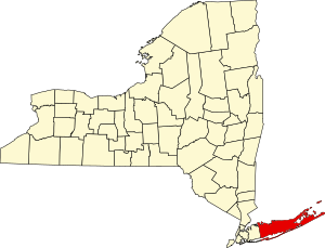
Suffolk County, New York
Suffolk County | |
|---|---|
 | |
 Location within the U.S. state of New York | |
 New York's location within the U.S. | |
| Coordinates: 40°56′N 72°41′W / 40.94°N 72.68°W | |
| Country | |
| State | |
| Founded | 1683 |
| Named for | Suffolk County in England |
| Seat | Riverhead |
| Largest town | Brookhaven |
| Area | |
| • Total | 2,373 sq mi (6,150 km2) |
| • Land | 912 sq mi (2,360 km2) |
| • Water | 1,461 sq mi (3,780 km2) 62% |
| Population | |
| • Total | 1,525,920 |
| • Density | 1,637.0/sq mi (632.0/km2) |
| Time zone | UTC−5 (Eastern) |
| • Summer (DST) | UTC−4 (EDT) |
| Congressional districts | 1st, 2nd |
| Website | www |
| Population is the official 2020 census count | |
Suffolk County is a county in the U.S. state of New York. It lies in central and eastern Long Island and makes up most of the island's territory, and is bordered by Nassau County to the west. In 2020, 1,525,920 people lived there.[1] The county seat is Riverhead.
Communities[change | change source]
Suffolk County is split into ten towns:
References[change | change source]
- ↑ 1.0 1.1 "QuickFacts: Suffolk County, New York". United States Census Bureau. Retrieved January 17, 2024.

