Shirebrook
Shirebrook is a town in the Bolsover district of Derbyshire, England, near Mansfield and Bassetlaw in Nottinghamshire, it had a population of 9,760 at the 2011 Census.Photo: al partington, CC BY-SA 2.0.
Notable Places in the Area
Holy Trinity Church, Shirebrook
Church

Photo: Dave Bevis, CC BY-SA 2.0.
Holy Trinity Church is a Grade II listed parish church in the Church of England in Shirebrook, Derbyshire.
Shirebrook railway station
Railway station
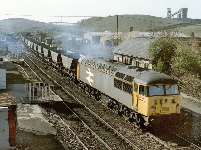
Photo: Dave Hitchborne, CC BY-SA 2.0.
Shirebrook railway station serves the town of Shirebrook in Derbyshire, England.
Shirebrook Academy
School
Shirebrook Academy is a coeducational secondary school with academy status, located in Shirebrook…
Localities in the Area
Whaley Thorns
Village

Photo: Dave Bevis, CC BY-SA 2.0.
Whaley Thorns is a former colliery village in the Bolsover district of Derbyshire, England, close to the Nottinghamshire border. Whaley Thorns is situated 2 miles north of Shirebrook.
Stony Houghton
Village

Photo: Alan Heardman, CC BY-SA 2.0.
Stony Houghton is a hamlet near Glapwell, part of the parish of Pleasley in Derbyshire, England, close to New Houghton. Stony Houghton is situated 2 miles southwest of Shirebrook.
New Houghton
Village

Photo: Dave Bevis, CC BY-SA 2.0.
New Houghton is a former mining village in the Bolsover District of Derbyshire, England, 3 miles from both Bolsover and Mansfield. New Houghton is situated 2 miles southwest of Shirebrook.
Shirebrook
- Type: Town with 10,900 residents
- Description: town and civil parish in the Bolsover District of Derbyshire, England
- Categories: civil parish and locality
- Location: Shirebrook, Bolsover District, Derbyshire, East Midlands, England, United Kingdom, Britain and Ireland, Europe
- View on OpenStreetMap
Latitude
53.2063° or 53° 12' 23" northLongitude
-1.22053° or 1° 13' 14" westPopulation
10,900Elevation
285 feet (87 metres)United Nations Location Code
GB SIOOpen Location Code
9C5W6Q4H+GQOpenStreetMap ID
node 30241135OpenStreetMap Feature
place=townGeoNames ID
2637941Wikidata ID
Q2345424Shirebrook Satellite Map
© OpenStreetMap, Mapbox and Maxar
Also Known As
- Arabic: شايربروك
- Asturian: Shirebrook
- Belarusian: Шайрбрук
- Bengali: শিরেব্রুক
- Bulgarian: Шайърбрук
- Catalan: Shirebrook
- Cebuano: Shirebrook
- Chinese: Shirebrook
- Chinese: 史艾亚布鲁克
- Chinese: 史艾亞布魯克
- Chinese: 夏尔布鲁克
- Dutch: Shirebrook
- Egyptian Arabic: شايربروك
- English: Shirebrook, Bolsover
- English: Shirebrook, Derbyshire
- French: Shirebrook
- German: Shirebrook
- Gujarati: શાયરબ્રૂક
- Hebrew: שיירברוק
- Irish: Shirebrook
- Italian: Shirebrook
- Japanese: シャーブルーク
- Kannada: ಶಿರೆಬ್ರೂಕ್
- Korean: 셔브룩
- Lithuanian: Širebrukas
- Min Nan Chinese: Shirebrook
- Persian: شایربروک
- Polish: Shirebrook
- Portuguese: Shirebrook
- Russian: Ширброк
- Silesian: Shirebrook
- South Azerbaijani: شایربروک
- Spanish: Shirebrook
- Spanish: Shirebrook (Derbyshire)
- Swedish: Shirebrook
- Tajik: Шайрбрук
- Tamil: ஷிர்புரூக்
- Telugu: శిర్బ్రూక్
- Turkish: Shirebrook
- Urdu: شائربروک
- Volapük: Shirebrook
- Welsh: Shirebrook
Other Places Named Shirebrook
Localities in the Area
- LangwithVillage
- Warsop ValeVillage, 1½ miles east
- ScarcliffeVillage, 1½ miles west
- Nether LangwithVillage, 1½ miles northeast
Landmarks in the Area
- Shirebrook Village HallCommunity center
- The Park Infant & Nursery SchoolSchool
- The Park Junior SchoolSchool
- Kingsgate CentreSports venue
- Recreation Road Post OfficePost office
Popular Destinations in Derbyshire
Discover Derby, Chesterfield, Buxton and Matlock.
Escape to a Random Place
Discover other destinations in the world.
About Mapcarta. Thanks to Mapbox for providing amazing maps. Data © OpenStreetMap contributors and available under the Open Database License. Text is available under the CC BY-SA 4.0 license, excluding photos, directions and the map. Description text is based on the Wikipdia page Shirebrook. Photo: al partington, CC BY-SA 2.0.