
Sandouping
Sandouping
三斗坪镇 San-tou-p’ing | |
|---|---|
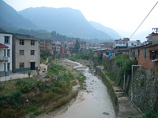
 On the Yangtze waterfront near Sandouping town center (Huanglingmiao Village), looking west toward Xiling Bridge and the Three Gorges Dam (not visible because of fog) | |
 Sandouping Location in Hubei | |
| Coordinates: 30°48′42″N 111°00′56″E / 30.81167°N 111.01556°E | |
| Country | People's Republic of China |
| Province | Hubei |
| Prefecture-level city | Yichang |
| District | Yiling District |
| Village-level divisions | 1 residential community 19 villages[1] |
| Area | |
| • Total | 178 km2 (69 sq mi) |
| Elevation (average)[2] | 480 m (1,570 ft) |
| Highest elevation | 1,197 m (3,927 ft) |
| Lowest elevation | 66 m (217 ft) |
| Population | |
| • Total | 29,494 |
| • Density | 170/km2 (430/sq mi) |
| Time zone | UTC+8 (China Standard) |
| Website | http://sdp.10.gov.cn/ |
| Sandouping | |||||||||
|---|---|---|---|---|---|---|---|---|---|
| Chinese | 三斗坪 | ||||||||
| Postal | Santouping | ||||||||
| |||||||||
Sandouping (Chinese: 三斗坪; pinyin: Sāndǒupíng[5][6]) is a town in Yiling District of Yichang prefecture-level city in the Chinese province of Hubei. It is located on the right (southern) bank of the Yangtze River, next to Yiling District's border with Zigui County to the west. Sandouping is best known as the location of the Three Gorges Dam, which is the world's largest electricity-generating plant of any kind.[7][8]
History[edit]
The predecessor of today's Sandouping, the village of Huangniupu (黄牛铺, "Yellow Cow Post Station") was established during the reign of the Hongzhi Emperor in 1496. Sandouping District was created in March 1949[9] and transformed into Sandouping Town in February 1984.[9][10]
Sandouping used to be a small fishing village until it was selected to be the site of the Three Gorges Dam. In 1999, at the peak of the construction, over 40,000 workers lived in Sandouping.[11] At the time, special permits were required to enter the town.[11]
Six out of nineteen Sandouping's villages are populated by families that have been resettled from the areas flooded by the waters of the Three Gorges Reservoir, or, earlier, the Gezhouba Reservoir.[12]
Geography[edit]
The Town of Sandouping occupies 178 km2 on the right (southern) bank of the Yangtze River, opposite the town of Letianxi (乐天溪镇), to which it is connected by Xiling Bridge.[4][13] Sandouping is the only town in Yiling District that is located south of the river.[14]
Sandouping's western neighbor is the town of Maoping, the county seat of the nearby Zigui County. Although it is only a kilometer or two west of the dam (straight-line distance), it is actually several kilometers drive on Hubei Provincial Route 134, because of the terrain.[13]
Administratively, the Town of Sandouping is divided into 19 villages (村) and 1 neighborhood committee (居民委员会).[12][15] Sandouping's central urban area, where the town government and most services are located, is technically known as Yuanyi Village (园艺村). It is situated some 5 km east of the southern end of the Three Gorges Dam. The neighborhood just to the east, known as Huanglingmiao Village (黄陵庙村), is named after Huangling Temple (黄陵庙) located there near the Yangtze River waterfront. It is being developed as a tourism area, centered around the riverboat dock.[13][12][15]
A secondary center of economic activity in the town is located in its western part, within walking distance from the service entrance to the Three Gorges Dam (Gaojiachong Village (高家冲) and Sandouping residential community).[12]
Administrative Divisions[edit]
One residential community:[1]
Nineteen villages:
- Huanglingmiao (黄陵庙村), Huangniuyan (黄牛岩村), Nantuo (南沱村), Yuanyi (园艺村), Qipanshan (棋盘山村), Zhongbao/bu/pu (中堡村), Gaojiachong (高家冲村), Shiban (石板村), Qiuqianping (秋千坪村), Huajipo (花鸡坡村), Dongyuemiao (东岳庙村), Xinsheng (新生村), Shipai (石牌村), Tianqiao (天桥村), Zhemuping (柘木坪村), Wuhe (务河村), Toudingshi (头顶石村), Muyang (暮阳村), Baiguotang (柏果埫村)
Economy[edit]
The town's economy is closely connected to the Yangtze River. Besides the Three Gorges Dam, major local enterprises include Hailun Shipyard (海轮造船厂) and Fazhong Vessel Servicing Company (发中船务有限公司).[4]
The three main agricultural products of Sandouping are citrus fruits (according to different governmental sources, 15,000 mu [ 1,000 hectares][4] or 10535 mu [702 ha][2] under cultivation, with an annual harvest of 14,000 metric tons[2]), silkworms (14400 mu/ 960 ha of mulberry plantations), and tea (3316 mu/ 221 ha).[4]
The town's authorities are working on expanding tourism in the area.
Gallery[edit]
-
 Dam facility's service entry, near Sandouping's western neighborhood. Part of the dam can be seen in the background
 -
 Workers' neighborhood in Sandouping near the southern entrance to the Three Gorges Dam
 -
 Huangling Temple
 -
 Pomelos or grapefruits in the neighboring town of Letianxi


See also[edit]
References[edit]
- ^ a b 2018年统计用区划代码和城乡划分代码:三斗坪镇 [2018 Statistical Area Numbers and Rural-Urban Area Numbers: Sandouping Town] (in Simplified Chinese). National Bureau of Statistics of the People's Republic of China. 2018. Retrieved 9 February 2019.
统计用区划代码 城乡分类代码 名称 420581001001 111 东风社区居委会 420581001002 111 胜利社区居委会 420581001003 111 清江社区居委会 420581001004 111 名都社区居委会 420581001005 111 解放社区居委会 420581001006 111 红春社区居委会 420581001007 112 中笔社区居委会 420581001008 112 头笔社区居委会 420581001009 111 八字桥社区居委会 420581001010 111 锦江社区居委会 420581001200 220 亮家垴村委会 420581001201 112 太宝湖村委会 420581001202 112 驿马冲村委会 420581001203 112 车家店村委会 420581001204 112 尾笔村委会 420581001205 112 十里铺村委会 420581001206 112 三江村委会 420581001207 220 宝塔湾村委会 420581001208 220 龙窝村委会
- ^ a b c 三斗坪镇概况 Archived 2011-07-07 at the Wayback Machine Sandouping Town Overview, at the town government's site
- ^ 夷陵区历史沿革 [Yiling District Historical Development] (in Simplified Chinese). XZQH.org. 14 July 2014. Retrieved 17 October 2018.
2010年第六次人口普查,夷陵区常住总人口520186人,其中:{...}三斗坪镇29494人,
- ^ a b c d e 三斗坪镇[permanent dead link] (Sandouping Town), at the official site of Yiling District. (The article does not specify the year when the population was estimated; but other statistics, as well as population counts for other towns in the district, are dated 2007) (in Chinese)
- ^ 三斗坪镇园艺村书记刘晓华 [Secretary Liu Xiaohua of Yuanyi Village in Sandouping Town]. 17 July 2016. Retrieved 14 February 2019.
照片的主人公叫刘晓华,是三斗(dǒu)坪园艺村党支部书记(at 0:10){...}然后,又马不停蹄地赶到三斗(dǒu)坪镇中心幼儿园旁,组织人员(at 0:50)
- ^ 三斗坪镇黄陵庙村书记杨年建 [Secretary Yang Nianjian of Huanglingmiao Village in Sandouping Town]. 17 July 2016. Retrieved 14 February 2019.
在三斗(dǒu)坪镇(at 0:09){...}
- ^ "top-100-pt-4". Industcards.com. Archived from the original on 2012-10-06. Retrieved 2009-08-01.
- ^ "Three Gorges dam wall completed". BBC News. 20 May 2006. Retrieved September 26, 2009.
- ^ a b 夷陵区历史沿革 [Yiling District Historical Development] (in Simplified Chinese). XZQH.org. 14 July 2014. Retrieved 14 February 2019.
1949年3月,宜昌县政府成立,设{...}三斗坪10区{...}1984年2月,政社分开,恢复区、乡建制,全县设小溪塔、三斗坪两个县辖镇{...
} - ^ 三峡工程所在地三斗坪镇将建国际旅游明星镇 (Sandouping Town - home to the Three Gorges Project - will transform itself into an international tourist destination) (in Chinese)
- ^ a b Kamran M. Nemati (November 1999). "Civil Engineering Delegation to the People's Republic of China". University of Washington. Retrieved September 26, 2009.
- ^ a b c d 各村概况 Archived 2011-07-07 at the Wayback Machine (Summary of [Sandouping's] individual villages)
- ^ a b c Road Atlas of Hubei (湖北省公路里程地图册; Hubei Sheng Gonglu Licheng Dituce), published by 中国地图出版社 SinoMaps Press, 2007, ISBN 978-7-5031-4380-9. Pages 26-27 (Yichang Prefecture-level City), or any other comparable atlas. Similar geographic info can be seen with Google Maps, at the coordinates in the infobox, or upon entering "Letianxi, Hubei. China" in the search box.
- ^ Schematic map showing the division of Yiling District into counties at 夷陵概况[permanent dead link] (Overview of Yiling District), compared to the county map in the provincial atlas
- ^ a b 宜昌市夷陵区三斗坪行政区划图 Archived 2011-07-07 at the Wayback Machine Sandouping Town (Yiling District, Yichang City) area planning map] - detailed map of the town (the entire administrative area) at the town government's official site (in Chinese)