
This fall, Saint Paul completed five major new bikeways, the most in the city’s history. We’ll look at all five of them and discuss some of the political and design work that enabled each of them to happen.
Como Avenue
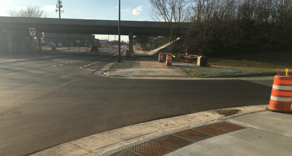
First up is a multi-use, off-street trail on Como Avenue between Raymond Avenue and Hamline Avenue (the western edge of Como Park). There were on-street bike lanes on Como from the park to Snelling Avenue but, west of Snelling, they disappeared. There were also on-street bike lanes west of Raymond Avenue but, as you headed east towards the State Fair Grounds, these also disappeared. The resulting gap between Snelling and Raymond made accessing the State Fair by bicycle a hazardous endeavor. The UMN Transitway also ended right in the middle of this gap, which made it difficult for bike commuters to safely access it. Finally, Raymond Avenue is one of the few great north-south bikeways in this part of Saint Paul and there are plans to continue it north to Larpenteur Avenue next year as an off-street trail. It needed a better east-west connection to Como.
Como Avenue is part of the Saint Paul Grand Round – a circle of parks and bike trails that goes around the entire city. Just before the Saint Paul Bicycle Plan was passed in 2015, the city made plans to complete this circle of trails and applied for federal funding to add or upgrade bikeways on Wheelock Parkway, Johnson Parkway, Pelham, Raymond and this portion of Como Avenue. Several public meetings and open houses happened for the Como project at the historic Streetcar Station in Como Park. In total, at least a hundred people attended them or submitted online comments. The portion east of Snelling was somewhat controversial due to the desire to preserve older trees and on-street parking.
The final design is excellent. It features an off-street, multi-use trail on the north side of Como Avenue from Raymond all the way to Como Park, with tabled crosswalks east of Snelling and additional on-street bike lanes on portions of the street. West of Snelling, the trail and bike lanes were made possible by doing a 4-lane to 3-lane conversion of the street. On the east end, the new trail segues nicely into the Como Park trails. On the west end, it becomes on-street bike lanes and will eventually connect with a new, off-street bikeway on Cleveland Avenue that is coming in 2021-22.
Johnson Parkway
Next up is a new off-street trail on the east side of Johnson Parkway from Lake Phalen and the Bruce Vento Trail all the way south to Burns Avenue. There were on-street bike lanes on this portion of Johnson Parkway but these were somewhat harrowing due to high-speed traffic and turning vehicles at numerous cross streets.
The new trail runs on Johnson Parkway’s eastern median for much of its length. The city closed off every other cross street to make the trail safer and more pleasant to use. This was controversial because some neighborhood residents didn’t like the idea of through traffic being closed off on their streets. But enough cyclists and trail supporters showed up to the public meetings and Council member Jane Prince ultimately argued for and supported the trail. Like Como Avenue, Johnson Parkway is part of the Saint Paul Grand Round and received some federal funding.
9th and 10th Streets

Next was the interim implementation of the Capital City Bikeway (CCB) on 9th and 10th Streets in downtown Saint Paul. Nowhere in Saint Paul is there a bigger gap in bicycle infrastructure than downtown. The Saint Paul Bicycle Plan calls for a loop or box of off-street bikeways in downtown and several spur trails to connect downtown to its various neighborhoods. The northeast side of the box is Jackson Street (and part of Sibley Street) from the Mississippi River to University Avenue and the Gateway Trail. The southeast side of the box is Kellogg Avenue, from John Ireland all the way to Mounds Boulevard on the East Side. The southwest side of the box is Saint Peter Street from Kellogg to John Ireland. And the northwest side of the box, is 9th and 10th Streets.
The city completed the Jackson Street bike facility several years ago. It’s beautiful but it cost over 16 million dollars, largely for sewer work and completely rebuilding the street, including curbs and gutters. Saint Paul has a smaller tax base than Minneapolis partly because so much property in the capital city is owned by government agencies, NGOs or non-profit organizations that don’t pay property taxes. As a result, except for a few projects, they haven’t had the funds to implement a lot of bike facilities. Instead the city has adopted a policy that, if a street is designated for bikes in the Bicycle Plan, the bikeway will be implemented when the street comes up for repaving or reconstruction. 9th and 10th weren’t being reconstructed but portions of them were getting repaved. Given that it was an area of great need, it seemed like a moment that the city could implement the promised bikeway cheaply, in an interim way, until more funding becomes available for a full reconstruction. The city held at least a dozen public meetings over the last five years to hammer out the route of these downtown bikeways and exactly how they would be designed. As always, removing parking was extremely controversial and many residents and businesses opposed the new bikeways. But bike advocates have continued to show up, write their council members and grind the project forward. Parking was saved on part of 10th Street by making it one-way and thus freeing up a driving lane for parking. Last year, this interim implementation was finally approved.
The interim implementation was done with just paint, plastic poles and concrete curb delineators. Due to a very narrow space, the portion of 10th where it crosses the LRT line at Cedar and jogs northwest is terrible and it probably won’t get better until funding – and political will – becomes available to move the retaining wall around the history theater. That said, 9th and 10th are a nice addition to downtown that connects the east side (via Broadway, Lafayette, Tedesco and Payne Avenues) to Jackson Street and the rest of downtown. Soon it will also connect to an interim bikeway on St Peter Street, which we hope will be implemented in 2021 or 2022. The new interim facility on 9th and 10th establishes what will eventually be the permanent configuration of these streets, and it creates a little more safe space for bicycles in downtown.
Robert Piram Regional Trail

Dan Marshall wrote an excellent piece for streets.mn on this new trail that includes great photos, maps and graphics, so I won’t go into a lot of detail about it. Since he wrote his piece, however, the trail has been completed and officially opened. It’s beautiful. It connects the Lilydale trail with Kaposia Landing and the Mississippi River Trail to the south, via Plato Boulevard and a nice trail along the edge of the Saint Paul airport that goes through wetlands and woods. While not politically controversial, it required easements and collaboration from multiple agencies and landowners and required federal funding that nearly expired before the project could get under way. Before this new trail, the only way for cyclists to go south along the west side of the Mississippi was via Concord Road, which has high-speed motor vehicle traffic and, in some places, narrow shoulders. This new trail makes the journey south infinitely safer and more pleasant.
Ayd Mill Trail

Finally, there’s the new Ayd Mill Trail. On November 7, the Ayd Mill Trail was officially opened with a speech by Mayor Melvin Carter, with over 100 cyclists and three city council members in attendance. It runs from Jefferson Avenue north to Selby Avenue with signalized entrance/exits at St Clair, Grand and Ashland/Hamline Avenues. To my knowledge, it’s the first time in state history that a highway lane has been converted to a multi-use trail. It’s also the most fought-over section of road and bikeway in the city and part of a struggle that stretches back almost 30 years.
I’ve written extensively on the history of Ayd Mill Road for streets.mn, as well as some of the issues involved in extending the Midtown Greenway, so I won’t rehash it here, but in the following paragraphs, I’d like to give thanks to all of the people and groups that helped to make this trail possible.
It all began with Neighborhoods First! Since the 1990s, this Union Park community group has fought to turn the Ayd Mill corridor into a linear park. They’ve attended countless city and community meetings, created websites, written letters, turned out supporters at public meetings, and organized major protests. They got the linear park chosen as the “preferred alternative” in a draft environmental impact statement in the 1990s. In the early 2000s, they fought mayor Randy Kelly’s unilateral action to open the south end of Ayd Mill Road to I-35E and his attempts to connect the north end to I-94. Some group members served on the Merriam Park and then Union Park district councils and, through it all, kept the dream of a linear park alive. Folks like Mike Madden, Debbie Meister, Steve Hauser and many others worked their butts off over the years to try and realize the linear park dream and keep Ayd Mill from becoming just a connector freeway between interstate highways.
Russ Stark, former chair of the now-defunct Bicycle Advisory Board, former city council president, and current advisor to mayor Melvin Carter, has done an enormous amount of work to move the Ayd Mill project forward. Stark has worked on transportation and land use issues for over 20 years. He supported the linear park and opposed turning Ayd Mill into a freeway connection between I-94 and I-35. In the late 2000s, he also created a Greenway Committee that Mike Madden, myself, Paul Nelson and others participated in to look into extending the Midtown Greenway across the river into Saint Paul and down the Ayd Mill corridor. It was probably because of Russ Stark that Mayor Carter proposed creating this new multi-use trail as part of an Ayd Mill repaving project.
Advocacy groups have also played a key part in making the Ayd Mill trail a reality. The Northstar chapter of the Sierra Club has collaborated on several bicycle and pedestrian projects with the Saint Paul Bicycle Coalition and other community groups. They and the Midtown Greenway Coalition organized a big event at Lake Monster Brewing last year to promote extending the Midtown Greenway into Saint Paul and promote the newly proposed Ayd Mill Trail. Hundreds of people attended, including elected officials and news media. The event generated over 300 postcards and e-mails to the mayor and Saint Paul City Council urging them to support the Ayd Mill Trail and a Greenway extension.

Then there were Bicycle Coalition members and local community activists who wrote articles, sent letters, made e-mail forms and met with each of our city council members, one-on-one to lobby for the trail. It quickly became apparent that two councilmembers – Mitra Jalali and Amy Brendmoen – supported the trail, and three others – Dai Thao, Chris Tolbert and Rebecca Noecker – opposed it. In the final days, it came down to Councilmembers Nelsie Yang and Jane Prince, who ultimately supported the trail and enabled it to happen.
The staff at the Saint Paul Department of Public Works deserve credit for committing to making the Ayd Mill project a success. Former city council president and public works director Kathy Lantry pushed the project forward, taking flack from some of the Council members who opposed it. Her successor, interim director Paul Kurtz and his staff managed to make excellent virtual presentations amid the COVID-19 pandemic and they ultimately designed a nice trail, working within the city’s severe budget constraints. When problems came up with the trail potentially destroying trees at the Eleanor Graham Community Garden (at the Ashland Avenue entrance), project managers Jary Lee and Reuben Collins worked to change the plan to reduce impacts on the garden and, in the process, created a better, safer trail.

Finally, there was the mayor himself, Melvin Carter, who proposed the trail and stuck with it, even when the cost for it escalated and drew criticism from some members of the city council, the media and the public. It took all these people talking to each other and working together to get this trail built and I’m deeply grateful to all of them. We hope this trail is just “Phase One” of a Midtown Greenway Extension along the south side of the Canadian Pacific Rail line, all the way to the Mississippi River and over to Minneapolis. But, even if we’re unable to accomplish this, the Ayd Mill Trail is an excellent community resource in its own right. Hopefully, some day in the future, we can reduce the road still further and turn the trail into a real linear park. If we all dream big and work together, anything is possible.
