Hike Mount Mansfield; 4 Routes up VT’s Tallest Mountain!
Ahh, Mount Mansfield – posturing proudly at 4,393 feet within and above the wilderness near Underhill, Vermont! Whether you’re an avid hiker looking for a challenge or if you want to drive up, read on for 3 hikes and one drive to the top of Mount Mansfield, Vermont’s tallest mountain.

I loved checking this one off my VT hiking list but admit I was intimidated at first to hike it. It was my first 4,000-footer in New England and at the time considered myself an intermediate hiker. So if you’re not a master peak bagger then I don’t want to say “you’ll be fine” because any hike up Mount Mansfield is a challenge. But if you treat it like any other hike with one foot in front of the other, you can get to the top of Vermont’s highest peak, too!
I hiked it in the summertime with a small group of people which is always a bit more motivating, because who wants to be the last one to the top of the mountain?! I was, anyway, but that’s ok! I made it and that’s what matters.
And in this post, you will choose which trail is going to get you to the top, too! No matter how long it takes. 🙂


We compare trail lengths, difficulty, highlights, and pros and cons of each hike with the info on the scenic drive listed at the end.
3 Different Hikes Up Mount Mansfield
1. Mount Mansfield via the Long Trail & Hazelton Trail: A Classic Wilderness Journey

- Miles: 7.8 miles
- Elevation: 3,720 ft elevation gain
- Level: Hard
- Trail Type: Loop
- Average Time: 5-6 hours
- Parking: Navigate here: 44.53305, -72.78655 Lot along 108/Mountain Rd near Barnes Visitor’s Center and The Lodge at Spruce Peak
- Dog-friendly: not suggested as there are ladders & some tricky climbs
- Trail Highlights: Once above tree line you’re rewarded with amazing views and a tricky climb up to the Chin from the Adams Apple and down the Forehead!
- Helpful AllTrails Review: “There’s no flat on the way up or down which is why it makes it a very difficult hike. Great view along the Ridge trail! Note that there is no such thing as a crevasse or anything close to that anywhere on the mountain as mentioned by other people. I’m scared of heights and felt comfortable the whole time on the Ridge.”
Overview: This route features the Long Trail which, in its entirety, stretches over 270 miles. From its southerly genesis in Massachusetts all the way to Canada, it’s one of the more rigorous yet rewarding trail systems in the United States.
This is the route for you if you want to hit all of Mount Mansfield’s features; the main view, the view from the Chin, and the view from the Adam’s Apple. (Note, the second trail on this list hits all of these except the Adam’s Apple! :))
This route begins at the eastern base of the mountain, offering a true pioneer-like wilderness experience as you wind your way through lush lively forests, alpine meadows, and up mazes of gnarled boulders.
Trail Guide for the Long Trail & Hazelton Trail
There’s a nice little parking area off of Route 108 in Lamoille County, Vermont where you’ll find the Long Trail and begin your climb.
The suggested route is counterclockwise, going up the Long Trail first. About 0.4 miles in you begin the It very steady and challenging climb up up the LT. You’ll ascend about 2,500 ft of elevation gain for over just 2 miles before taking a right to head to and check out the Adam’s Apple (4,128 ft). And don’t worry, it’s only a flat 0.1 miles to get to the Adam’s Apple so it’s worth it!
After checking out the view from the Apple, turn around and take the 0.1 miles to meet back up with the Long Trail and head straight to continue your loop on the Long Trail. At this point you have about a third of a mile to get to the top of Mansfield.
Take in the 360 degree views up here (it’s windy!) and then you have a choice – you can either return the same way you came, descending via the LT the 2.5 miles to your car, or you can continue south on the LT.
If you decide and continue on to finish this loop you will walk a relative flat couple of miles over the ridge here. You’ll pass over the Upper Lip (3.6 miles in), the Nose (4.2 miles in), and the Forehead (4.6 miles in), all prominent features and summits in their own right.
At about the 5-mile mark, you’ll get off the Long Trail and make a left onto the Forehead Bypass. The trail crosses over an access road and at this point, about 6.1 miles in, the long descent begins along the Hazelton Trail.
The one negative part about this trail is the steep descent…
You’ll descend about 1,700 feet in the next 1.3 miles until you get back down to the lot. (But it’s steep even if you go counterclockwise – there is no easy way up or down so expect steepness on both ends.)
Hopefully somewhere to get something good to eat or drink! Congrats, you just climbed Vermont’s tallest mountain!! 😍👏
Trail Highlights:
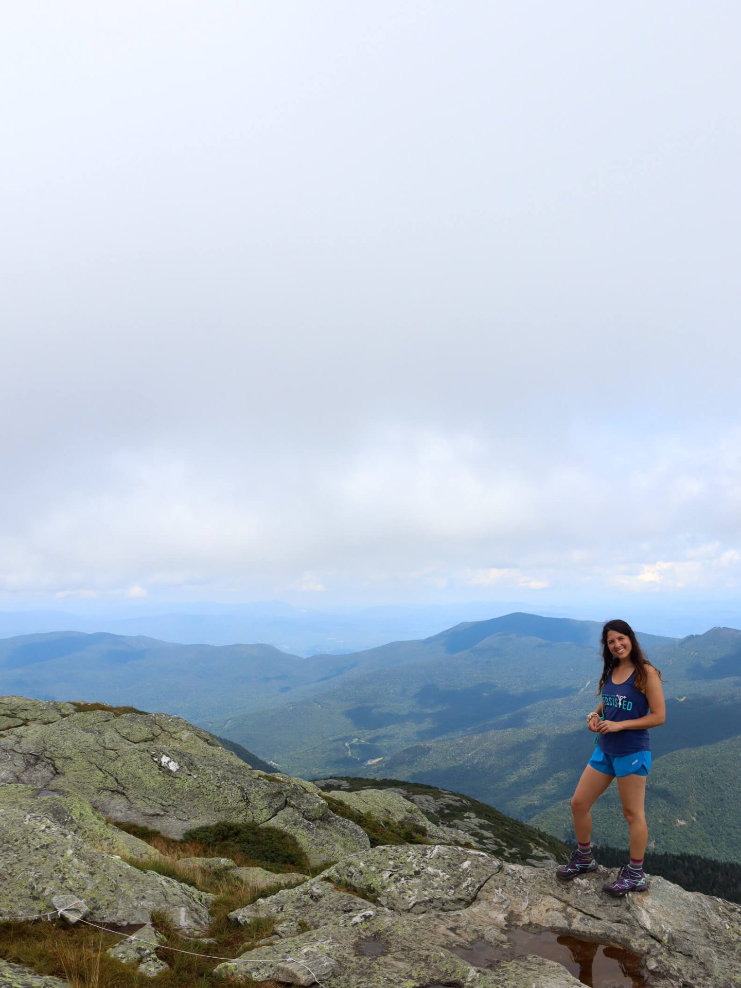
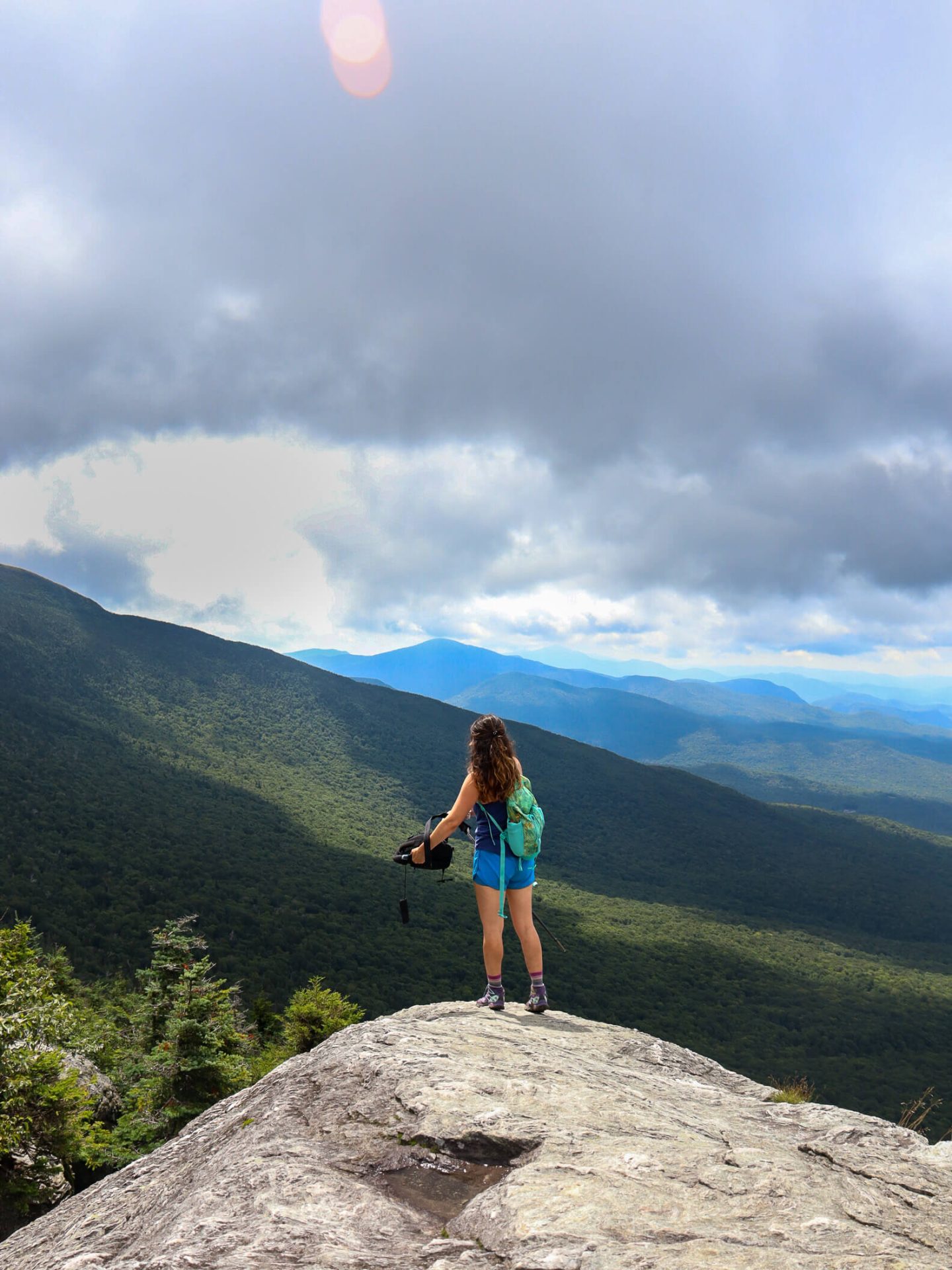
- The Chin: Strutting atop the summit, known as “The Chin,” a climber is spoiled with amazing 360-degree vista views, which include the Green Mountains and neighboring White Mountains in New Hampshire.
- Profanity Trail Connection/Option: This trail connects and offers the option to ascend via the Profanity Trail, a more technical route that adds an extra rocky layer of challenge. If you take this way you will be skipping the Adam’s Apple.
2. Mount Mansfield via Sunset Ridge & Laura Cowles Trail: A Shorter, Steeper Route


- Miles: 4.5 miles
- Elevation: 2,555 ft
- Level: Hard
- Trail Type: Loop
- Average Time: 4 hours
- Parking: Navigate Here, parking at the end of Mountain Rd
- Dog-friendly: Yes
- Trail Highlights: Once on the Long Trail ridge and much of Sunset Ridge you’ll get beautiful views of the Lamoile and Stowe Valleys.
- Helpful AllTrails Review: “What began as a total newbie choice (I thought, “this trail is half the mileage down, I’ll take it!”) ended with gratitude that I did, because it was beautiful and a technically challenging and fun choice. Wet as expected, I’d recommend waterproof gloves or at least a dry pair to change into at the bottom because you may be using 4-points of contact at various times.” Aurora River 10/29/23
Overview: The Laura Cowles Trail combined with Sunset Ridge, is renowned for its steep ascent and craggy terrain, making it a favorite among experienced hikers.
This is a great route if you’re looking for a hike that covers all of Mount Mansfield’s main views and points except for the Adam’s Apple. For just 4.5 miles, this loop will give you some of the most outstanding views in the entire state of Vermont.


Trail Guide for the Sunset Ridge & Laura Cowles Trail
Park at the end of Mountain Road in Underhill, Vermont. Follow the “CCC Road” for about .8 miles and about 500 ft of elevation gain until you reach a juncture with the Sunset Ridge trail.
Take a left to go on the Sunset Ridge Trail. We will be doing this loop clockwise.
Follow the trail for half of a mile and almost 1,000 feet up! Woah. This part of the trail is tough.
After that strenuous 0.5 miles you’ll reach the Long Trail where you’ll take a left and head north for another .2 miles until reaching the summit. There are rock scrambles in a few places! You’ll want both hands free here.
After taking int he views at the top you’ll return the way you came down that short section of the Long Trail to that juncture with the Sunset Ridge Trail. You will now go left on the Laura Cowles Trail (not the Long Trail whose left hand turn comes up right before Laura Cowles.)
Continue your way down this end of the loop.
But don’t let your guard down just yet! Coming down Sunset Ridge is mainly exposed rock for the first two-thirds of the way.
You’ll descend about 1,500 feet in just a mile here!
You’ll be happy to meet back up with the trail you started on (CCC Road) for the last much less treacherous mile. 🙂
Congrats! You just hiked Vermont’s tallest mountain at 4,393 feet (1,339 m) above sea level.
Highlights:
- Exposed rocky spine of Sunset Ridge: As the trail gains elevation, hikers are treated to stunning panoramic views of the Champlain Valley and the westerly laying Adirondack Mountains. Can watch the sunset from here!
- The Chin: Strutting atop the summit, known as “The Chin,” a climber is spoiled with amazing 360-degree vista views, which include the Green Mountains and neighboring White Mountains in New Hampshire.
- Views of the Lamoille and Stowe Valleys: Take a trip backward through time as you gaze upon these quintessential New England valleys. Carved by glaciers thousands of years ago, this land is dotted with seventeenth and eighteenth-century buildings, beautifully landscaped farmland, curling rivers, and pristine freshwater lakes.
3. Mount Mansfield Loop Trail, The Thrill Seeker’s Route
- Miles: 7.7 miles
- Elevation: 2,893 ft
- Level: Hard
- Trail Type: Loop
- Average Time: 5-6 hours
- Parking: Navigate Here, parking at the end of Mountain Rd (which is off of Pleasant Valley Rd)
- Dog-friendly: Difficult and maybe not recommended unles your dog is more like a mountain goat and can find their way along and around technical and tricky spots.
- Trail Highlights: A challenging rock wall to scale.
- Helpful AllTrails Review: “Went early November. ICY throughout. You’ll NEED spikes & highly recommend hiking poles. Steep descent, there is internet service.. So if you dislocate your shoulder you can look up how to relocate it on youtube. Cheers.” Hugo Bissonnette 🙂 11/26/23
Overview: This is a very technical climb so please read below before choosing and use caution! I have not done this one yet so I will be including all information from AllTrails below.
This is the route for you if you aren’t afraid of heights and enjoy the challenge of serious scrambles that feel more like rock climbing in parts. It will challenge the experienced hiker both physically and mentally.
Trail Guide Up the Mount Mansfield Loop Trail
The hike starts along CCC Road. You will continue on CCC Road for about 0.7 miles and about 500 ft of elevation until you reach Maple Ridge Trail.
Note from AllTrails: Maple Ridge Trail is the most technical part of the hike. Two parts of the Maple Ridge Trail stand out as scariest. One is a rock wall that has only limited grips and toe holds, and a fall off that wall would cause serious harm. The second part is a chasm about six feet deep that you have to leap over. As with climbing the rock wall, there is no margin for error with this leap. You have to commit and then execute properly.
The average adult may find it frightening but will be able to do it safely. Because of these two challenging sections, it is not recommended to attempt this hike in bad weather conditions where the rocks would be wet or icy.
After that intense and mildy scary climb, about 3.1 miles in to your hike, you will reach (and the trail will become) the Long Trail.
Continue along the Long Trail north where you’ll pass over the forehead, the nose (3.6 total miles in) and northward along the ridgeline to the Chin.
From there, the Chin you can extend the trip up to Adams Apple or turn around to meet back up with the loop and take a right to descent along the Sunset Ridge Trail.
Trail Highlights:
Ascent views: once you get to the rocky outcrops on the Maple Ridge Trail
Descent views: on the Sunset Ridge Trail.
AllTrails also notes that, “This is one of the best trails in the state of Vermont.”
4. The Toll Road: Drive and Hike Adventure
For those seeking a more relaxed and automotive ascent, the Toll Road will provide a unique blend of squirrelly driving and hiking.
Accessible by car, the Toll Road takes visitors on a scenic journey via switchbacks through dynamic landscapes, culminating in a hike to Mansfield’s summit.
- Dates: End of May through mid October
- Hours: 9:30am – 4:30pm
- Price: $32/car and $12/passenger
- Vehicle Restrictions: No trailers, RVs, campers, or vans converted to RVs.
- Bikes allowed? No motorcycles, bicyles, mopeds or scooters
- Parking: Visit Stowe.com for more details on the Auto Toll Road
Highlights:
- Auto Toll House: This journey begins at the historic Auto Toll House, where you’ll pay a fee to begin your ascent up the Toll Road. The drive features charming hairpin twists and turns, pleasantly enclosed by vibrant foliage in the fall and blooming wildflowers in the summer.
- Nosedive Trail: When you reach the parking lot near the summit, hikers can take the Nosedive Trail for a short, challenging but invigorating final uphill push. Prior to the all encompassing views that await, this trail offers glimpses of the surrounding valleys and showcases the rugged beauty of Mount Mansfield.
- Visitor’s Center: At the summit, the Visitor’s Center provides a cozy space to recharge and enjoy some refreshments while taking in some endless and awe-inspiring views. (No food or dining) This unique combination of driving and hiking makes the Toll Road a relatively accessible and easier option for getting to the top of Vermont’s tallest mountain.
Happy climbing Mount Mansfield!


Looking to climb another of Vermont’s 5 high peaks?! Check out this post here – a guide to hiking Camels Hump!

Whether you want miles of solitude in the forest, a challenging climb with open ascents and rocky ridges, or a scenic drive, I hope you found your path up Vermont’s highest peak! ⛰
Whichever route you choose remember to leave no trace, respect the natural beauty of this environment, and savor every moment of the adventure.
Mount Mansfield FAQ’s
It depends on which of the 3 routes listed here you decide to take. The average time for the 4.5-mile route up Mansfield was 4 hours and for both 7+ mile trails, it was between 5 and 6 hours.
While still designated as ‘Hard’, the hike with the least amount of elevation gain and least sketchy/technical climbs is the 4.5-mile Sunset Ridge & Laura Cowles Trail.
All three Mount Mansfield hike routes listed here are designated as ‘hard’ or difficult on AllTrails. The Sunset Ridge & Laura Cowles Trail is the least technical of the three.
The Nose, just below Mount Mansfield in the Green Mountains of Vermont, is about 4,025 feet.
There are 3 different hikes to choose from, each featured in this article, along with a scenic drive to reach the top of Mount Mansfield. Note: The drive is not open year-round.
Yes, depending on the weather, from late May to mid-October (9:30 am-4:30 pm) you can take the Auto Toll Road up to the top of Mount Mansfield. Types of vehicles allowed along with prices listed in this article.
You can hike up Mount Mansfield from a few different trails in Underhill, Vermont. Parking information and GPS navigation are listed in this article for each trail.
The most scenic trail up Mount Mansfield would be the 7.8-mile route of the Long Trail and Hazelton Trail. This hike hits all of Mount Mansfield’s features; the main view, the view from the Chin, and the view from the Adam’s Apple.