100 years after the first ascent of the world’s northernmost active volcano, this team climbed it again. Here’s why.
In remote Jan Mayen researchers retraced the steps of a British scientist to the summit of the world's northernmost active volcano. Their expedition would be part tribute, part adventure—and part examination of the world’s fastest-changing environment.

Wind in excess of 40-knots howls across the mountain and I wince as the spindrift slashes at my face. I drive my axe into the hardpacked snow, glancing ahead to the silhouettes of my teammates: Norwegian expedition sailor and marine biologist Andreas B. Heide, and filmmaker Hugo Pettit. We shorten our rope in preparation for the ascent to come. A fall here could be fatal.
We’re on the remote arctic island of Jan Mayen, we’ve been awake for 22 hours, and just 200 vertical meters separate us from the summit of the world’s northernmost active volcano. It is 21 August 2021 – almost exactly 100 years since its first ascent.
A remote Arctic outpost
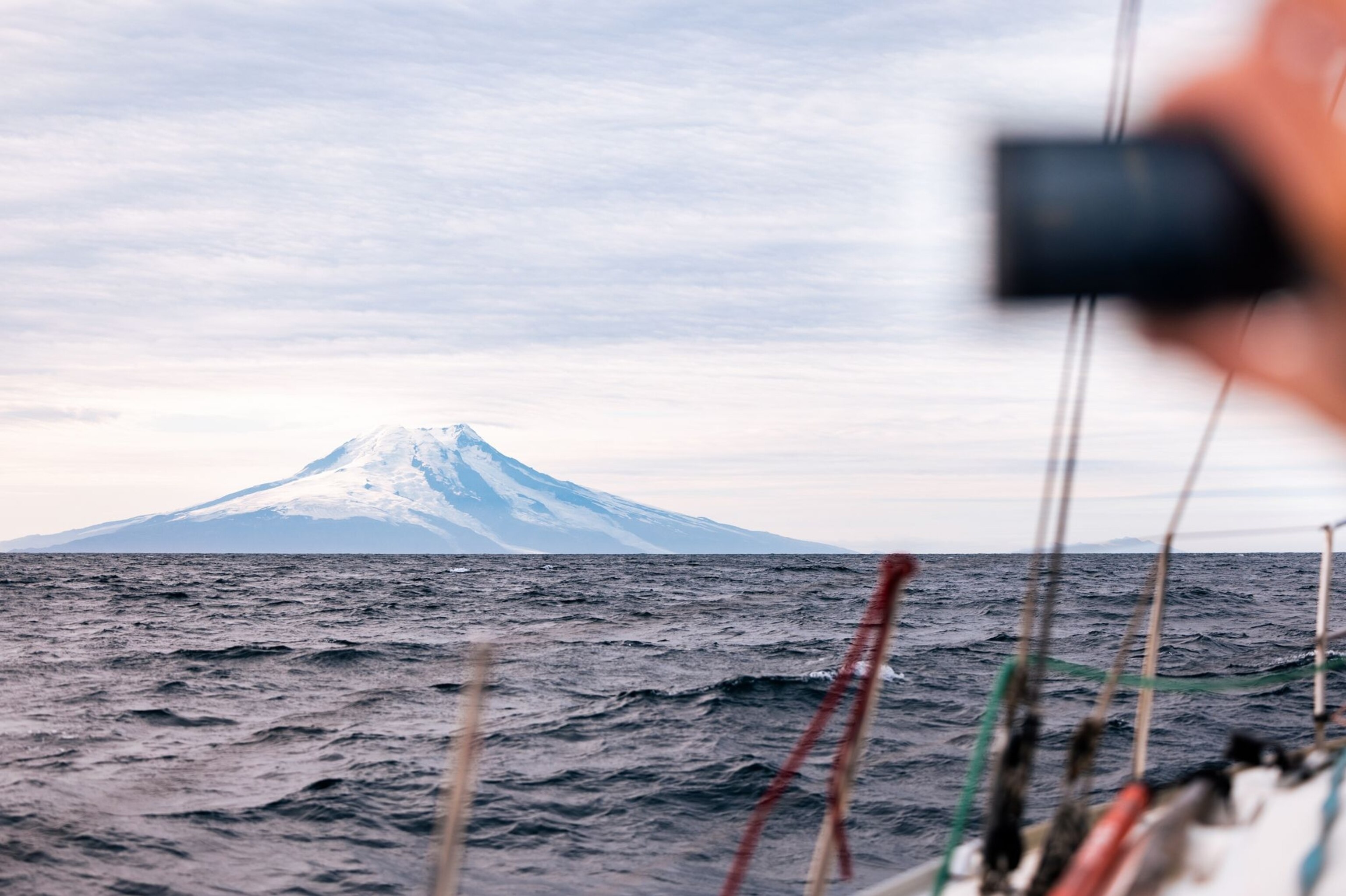
The volcanic island of Jan Mayen sprouts from the Mid-Atlantic Ridge (MAR) at 71o north between the Greenland and the Norwegian Seas, 500-km above the Arctic Circle. Its north is dominated by the stratovolcano Mount Beerenberg – an edifice sporting 20 glaciers, and topped by a 1km wide ice-filled crater with numerous peaks, including its summit, Håkon VII Toppen, at an elevation of 2,227m (7470ft).


Alone in over 2 million km2 of water and just 53km long, Jan Mayen may have first been discovered by the Vikings as early as the 9th century, appearing in Landnámabók, the medieval tome that chronicles the Norse settlement of Iceland. While an area of dispute, Henry Hudson may have first discovered the island in the modern age in 1607, naming it Hudson’s Tutches. In 1614, with the rise of whaling in the Arctic, Dutch captain Jan Jacobsz May laid territorial claims to the island which bears his name, and the Noordsche Compagnie began seasonal hunting operations on the island in 1615.
(Read: Magical places to experience the midnight sun this summer.)
Great stores of primarily bowhead whales were discovered in the Greenland Sea surrounding Jan Mayen, a result of migration routes and an abundance of prey caused by nutrient-rich meltwater from the Greenland Ice Sheet (GrIS). Dutch whaling records of the time indicate whales numbering in their thousands. Population size pre-commercial whaling is estimated to have been almost 50,000. By 1642, however, the local bowhead whale population had been hunted to near extinction, and Jan Mayen’s whaling enterprise ceased; the skeletal remains of bowheads can still be found on the island today.
(Meet the bowhead whale hunters of northern Alaska.)
In the two centuries that followed, there were numerous fleeting visits, and it was popularly romanticised by Lord Dufferin, who wrote vividly in Letters from High Latitudes about the island during his 1856 voyage. “The heavy wreaths of vapour seemed to be imperceptibly separating, and in a few minutes more the solid roof of grey suddenly split asunder, and I beheld through the gap—thousands of feet overhead, as if suspended in the crystal sky—cone of illuminated snow,” he writes of his first sighting of Mount Beerenberg.


Significant mapping was first undertaken by the Austro-Hungarians during the First International Polar Year, 1882-3. While they spent almost a year on Jan Mayen, their party was without a geologist, and they failed to summit Mount Beerenberg. It was a combination of these two factors that inspired the British, in 1921, to join a Norwegian party aiming to establish the first weather station on the island. In doing so, they also intended to assess the island’s economic viability—and claim the first ascent of the world’s northernmost volcano.
By 1930, Jan Mayen had been annexed by Norway. It was a source of much interest during WWII and has since had a continuous Norwegian military presence. A meteorological station still helps weather forecasting, and the LORAN A, then C and later EGNOS and current Galileo navigation systems are located there.
An anniversary adventure is born
In February 2020, in the Members’ room of the Royal Geographical Society (RGS), I found an original edition of the March 1922 Geographical Journal. Within it, I uncovered the 1921 Jan Mayen expedition report given by one James Mann Wordie at the Meeting of the Society in November of the same year.

As a young geologist and chief of scientific staff aboard Endurance during Ernest Shackleton’s Imperial Trans-Arctic Expedition, 1914-1917, Wordie developed a fierce passion for exploration. In 1921, the opportunity arose to join the first University of Cambridge Arctic Expedition to Jan Mayen, just months after the inauguration of the Scott Polar Research Institute (SPRI). “It (Jan Mayen) was an attractive proposition, both scientifically and personally,” writes his biographer, Michael Smith. “But what appealed most to Wordie was the prospect of climbing Mount Beerenberg.”
(Read: Endurance is finally found, frozen in time.)
The team comprised J. L. Chaworth-Musters as botanist, T.C. Lethbridge and W.S. Bristowe as naturalists, and Wordie as geologist. In cooperation with the Norwegian Hagbard Ekerold, who planned to build the weather station (now known as Eldste Metten), the Cambridge team was joined by Swiss glaciologist Paul-Louis Mercanton from Lausanne University, and they sailed from Ålesund in August 1921.
Wordie went on to become the Chairman of the Scott Polar Research Institute, President of the RGS, and in 1957 received a knighthood from King George VI for his contributions to Polar exploration. “On his return from Shackleton's Endurance expedition, Wordie became one of the most influential British scientists involved in polar work,” says Professor Julian Dowdeswell, Director, SPRI. “His support for the establishment of the SPRI, and his encouragement of a generation of young polar explorers and scientists, was of considerable significance in furthering the understanding of the Arctic and Antarctic over the next few decades.”

Reading the expedition report just weeks after returning from the Norwegian Arctic on a research mission to document sperm whales with captain Heide for National Geographic (UK), we had discussed the distant island of Jan Mayen in detail, which he had first visited in 2012 and which had left a lasting impression. Fortune had stuck and I called him immediately. With the discovery of the upcoming centenary, the decision was made. We would sail to Jan Mayen in a modern interpretation of a 100-year-old expedition.
Remote marine research
A contemporary expedition vessel, Heide uses Barba as a research and storytelling platform with a message of conservation, almost exclusively sailing in the Arctic and utilising whales as ambassadors for the oceans. As part of his 2021 mission, the Arctic Sense Expedition was formed; a 4-month, 3,000 nautical-mile scientific and communications voyage to study and document the polar Atlantic. Our Jan Mayen voyage would form part of the wider expedition.
“The impacts of climate change are unfolding far more rapidly and intensely in the Arctic than anywhere else,” says Heide. “Marine research in the Arctic is of special importance as the ecosystem is undergoing rapid change with retreating ice as a result of global warming. The retreating ice also brings with it an increased opportunity for commercial exploitation of the region, making it even more important to document what we are at risk to lose.”


As the project’s research partner, Whale Wise compiled a detailed programme to help study this remote environment. “Our aim was to monitor Arctic ecosystems, focusing on whales, in an unobtrusive way,” says Tom Grove, co-founder of Whale Wise. “Cetaceans are characteristically vocal species, allowing reliable detection through passive acoustic monitoring. Given the existence of towed systems, acoustic monitoring is well suited to the nature of an expedition like this.”
A contemporary centenary climb
Wordie’s expedition report vividly describes the ascent of Beerenberg, which they completed on the 11th of August 1921. The climbing party was comprised of Wordie, Lethbridge and Mercanton. Embarking from their basecamp near Eldste Metten, the party of three made their way up Ekerold Valley, so named in honour of their Norwegian comrade. From the advance camp they had previously established at the base of the frontal moraines of South Glacier, at an elevation of 2770ft (844m), they began the climb.
“For nearly 3000ft (914m) we toiled up a gentle uncrevassed slope to a prominent nunatak,” writes Wordie in the 1921 report. “No real difficulty was experienced, therefore, until at 7200ft (2195m) a broad crevasse had to be jumped.” Delays occurred when finding a route across the bergschrund, which Mercanton finally passed “by clever step-cutting up a short vertical ice-wall.” 150ft (45m) later, they reached the crater rim and summit proper. From the advance camp and back, the climb took them 8 hours.

Using Wordie’s report, we utilised contemporary 3D mapping software to plot the exact route the 1921 party took. As the route passed over South Glacier, we wanted to discover whether climate change had made the original route across the glacier impossible. With the help of the Deep Purple project led by Professor Martyn Tranter, Aarhus University, we also intended to discover whether there were any glaciological samples we could collect for further testing
An abundance of life
It’s a mild August evening when Barba sails into Longyearbyen following a successful circumnavigation of Svalbard. The new sailors arrive, Dutchman Jaap van Rijckevorsel and Norwegian Annik Saxegaard Falch, with Heide, Pettit and me completing the ensemble.


The water is calm, almost millpond as we sail out of Adventfjorden and into Isfjorden a few days later. There’s a hint in the air of autumn, a slight darkening to the sky and a crisp whisper in the breeze of the cold months to follow.
We continue to the mouth of Isfjorden. Rijckevorsel, who is on watch, bellows into the cockpit. “A pod of perhaps 10 fin whales are up ahead.” On deck, we spot them just 100m away. Moments later, another group appear. On the horizon, the air is filled with the blow (whale exhalation) of yet more fin whales. In total, Heide estimates there are as many as 50 individuals around us as he dons his wetsuit.
Pettit and Heide enter the water. From the surface, we see little, but beneath it is alive with marine activity. With an enormous bait ball to the stern, white-beaked dolphins and fin whales feed.


“From my experience, fin whales are hard to observe underwater, as they are shy and fast moving. But I picked out a lone individual with a behaviour indicating that it was worth approaching,” says Heide. “I have not seen any underwater footage of feeding fin whales, but during feeding, I observed large bubbles of air coming up from the deep. I do believe we have recordings of a new-to-science bubble feeding technique.”
At the edge of the MAR, the sea floor plummets from 200m to over 2000m. At many locations along its 16,000km length, it is a hotspot for cetaceans. Yet here in the Arctic, research into deep diving whales is sparse.
(Inside the unprecedented effort to decode whale language.)
As we sail onwards, Heide deploys the towed hydrophone off the stern to record and detect cetacean vocalisations. Connected to an amplifier and then to a computer with a spectrogram (to visualise vocal recordings), Heide observes the signals from the saloon. Within minutes, the familiar click of a sperm whale is heard. The hydrophone remains in situ for some 48 hours as we sail over the MAR.
For 5 long days, we follow the MAR towards Jan Mayen. Headwinds cause the bow to slam with ferocity, draining us of all energy. It’s 600 nautical miles across some of the most remote waters on earth. As the last landmass on the MAR, Jan Mayen has a varied bathymetry (seafloor elevation) which also indicates its likelihood as an area for deep-diving cetaceans. “A canyon, more than 3,500m deep in places, passes just a few kilometres from the island’s northern edge,” notes Whale Wise co-founder Allyssa Stoller. “Steep changes in bathymetry can cause upwelling, which increases phytoplankton blooms. This, in turn, increases prey stocks for cetaceans.” Heide also deploys the hydrophone in this location. “The data will be analysed in the coming months for cetacean occurrence and acoustic behaviour,” adds Stoller.
The lone volcano
At 6am on the 6th day, a gentle nudge on my shoulder wakes me. Rijckevorsel smiles down. “Do you want to see Jan Mayen?” he asks.

Ahead, partially obscured by low lying cloud, the northeast foot of Jan Mayen appears. The white slash of the Weyprecht Glacier is stark against the onyx rock as it reaches down and touches the ocean. But our first step on land comes two days later. With no harbours, only two permitted bays at which to land, and with the weather hostile and gusting at violent-storm forces of 57-knots whilst at anchor, it is a nervous time for us all.
When Jan Mayen became a Norwegian territory in 1930, and after skirmishes with the Germans during World War Two, a Norwegian military presence was established to protect the weather station. Today, the base at Olonkin City on the island’s southwest is maintained by 18 military personnel on 6-month rotations. And it is the current Station Commander, Svein Idar, who greets us when the weather abates, and we can finally paddle ashore. But he brings unfavourable news.
Jan Mayen became a nature reserve in 2010, and with it came many restrictions, including on landing locations and camping. As such, permission is denied to disembark near Eldste Metten in Jamesonbukta, where the 1921 party came ashore. We must complete the summit attempt in one 70km push from a location in Båtvika, some 20km further south.

Preliminary route planning was achieved through recent satellite imagery. From this, we observed wide crevasses toward the top of South Glacier on the original route. Conservative estimates measured these at 8 metres wide. When the summit cleared, the crevasses were confirmed; the 1921 route would not be achievable due to glacier degradation. Yet Wordie’s secondary route was achievable. As he said at the Meeting of the Society, “A prominent buttress juts south-west from the subsidiary top… we might have gained that buttress and followed it to the top by a snow bridge of fairly easy access.” Later he continued, “It (southwest buttress) probably offers the quickest if not the most interesting way to the summit.”
The long walk brings us across the now-drained, plastic-debris-strewn South Lagoon, past Eggøya and Jamesonbukta to the site of Eldste Metten. Though a wooden structure filled with volcanic sand and heavily abused by 100 years of Arctic storms, much remains as it was left. A stove with fire poker, gas lanterns, broken wine bottles. It is a historical landmark so infrequently visited that human presence has not affected the site. We document the structure and wait out the ever-darkening arctic night behind a small volcanic crater in Ekerold Valley.
At 1:52am we begin the ascent. By 7am we break through the clouds at the base of South Glacier. The artistry of the dawn light fills us with energy as we traverse its long, uncrevassed foot. But a front is coming in from the north. By midday, after crossing the crevasse field to the southwest buttress, the front has hit. In the whiteout, battered by the wind, the visibility is so poor that only the GPS lets us know we have reached the summit.


It is a short-lived moment of jubilation to stand on the top of the world’s northernmost active volcano, on the centenary of its first ascent – take a few days. The weather is worsening, our bodies are tired, and the tracker has malfunctioned. It makes for a nervous descent as there is no possibility of rescue here. Below the southwest buttress, the front finally abates, and the late afternoon sun illuminates South Glacier. We look up at the summit and embrace. It was hard-won.
A new discovery
Melting glaciers have lost an estimated mass of 267 gigatons over the past decade, contributing to over 20% of the observed sea-level rise. The largest contributor is the GrIS, and the Deep Purple project aims to document one of the causes - biological darkening produced by snow and glacier ice algae. Algal blooms create a dark zone on the west of the ice sheet, which subsequently absorbs solar radiation and contributes to increased melt rates.
“The GrIS is the biggest contributor of new water to the oceans each year,” says Tranter. “We need to know how much the Dark Zone will expand over the coming decades to accurately predict how fast sea levels will rise due to meltwater.” But biological darkening is also affecting other glaciers worldwide. On Jan Mayen, samples to test for snow and glacier ice algae had never been collected, and our descent offered the chance to change that.
Below the southwest buttress, pockets of red, pink, and green snow glisten in the fading light. At various elevations on our descent, we collect samples from these patches. Analysed at Aarhus University by principal investigator Professor Alexandre Anesio, the presence of snow algae was confirmed. “These samples are important because it just shows how widespread the colonisation of snow algae is across different glaciers worldwide,” he tells me.


“There is a massive biomass of microbes that helps the darkening of the snow, and I would not be surprised that in the next few years there is ice algae dominating the bare ice system which furthers the darkening.” In addition, Anesio discovered cryoconite material, where black carbon (soot) is likely to be found. Second only to CO2 as the major contributor to global climate change, evidence of black carbon would be alarming if not unsurprising. In the months to come, principal investigator Professor Liane G. Benning will test the samples for black carbon under an electron microscope at the GFZ German Research Centre for Geosciences.
The long journey back
36 hours and 70km since paddling ashore, we clamber back onto Barba. Our bodies have been battered by the mountain; our feet are pulps of flesh and our muscles have seized from fatigue. But rest must wait. Within 5 hours the weather has shifted, and the decision is made to set sail. What should have been a three-and-a-half day's sail to the Faroe Islands instead becomes 7 days of beating into headwinds, pushing us so far off course that we almost reach the Norwegian mainland before cutting back to the Shetland Isles.
The hostility of Jan Mayen makes it a seldom visited, infrequently studied part of the Arctic.
100 years after the Wordie party visited Jan Mayen, we have also witnessed a change in the purpose of exploration - while curiosity and the pursuit of knowledge unites us over time, our exploration today highlights the need to preserve our rapidly changing planet. “If we didn’t map the distribution of whales and the role of Arctic ecosystems, there would be no need to regulate our anthropocentric destruction of nature,” says Whale Wise's Tom Grove. “Only by knowing what life exists in a region can we ever hope to protect it.”
This article was adapted from the National Geographic U.K. website.
You May Also Like
Go Further
Animals
- What rising temperatures in the Gulf of Maine mean for wildlifeWhat rising temperatures in the Gulf of Maine mean for wildlife
- He’s called ‘omacha,’ a dolphin that transforms into a man. Why?He’s called ‘omacha,’ a dolphin that transforms into a man. Why?
- Behind the scenes at America’s biggest birding festivalBehind the scenes at America’s biggest birding festival
- How scientists are piecing together a sperm whale ‘alphabet’How scientists are piecing together a sperm whale ‘alphabet’
Environment
- What rising temperatures in the Gulf of Maine mean for wildlifeWhat rising temperatures in the Gulf of Maine mean for wildlife
- He’s called ‘omacha,’ a dolphin that transforms into a man. Why?He’s called ‘omacha,’ a dolphin that transforms into a man. Why?
- The northernmost flower living at the top of the worldThe northernmost flower living at the top of the world
- This beautiful floating flower is wreaking havoc on NigeriaThis beautiful floating flower is wreaking havoc on Nigeria
- What the Aral Sea might teach us about life after disasterWhat the Aral Sea might teach us about life after disaster
History & Culture
- This thriving society vanished into thin air. What happened?This thriving society vanished into thin air. What happened?
- These were the real rules of courtship in the ‘Bridgerton’ eraThese were the real rules of courtship in the ‘Bridgerton’ era
Science
- What will astronauts use to drive across the Moon?What will astronauts use to drive across the Moon?
- Oral contraceptives may help lower the risk of sports injuriesOral contraceptives may help lower the risk of sports injuries
- How stressed are you? Answer these 10 questions to find out.
- Science
How stressed are you? Answer these 10 questions to find out. - Does meditation actually work? Here’s what the science says.Does meditation actually work? Here’s what the science says.
- How to cope with stress at work—and avoid burning outHow to cope with stress at work—and avoid burning out
Travel
- Discover the sordid history behind these English country homesDiscover the sordid history behind these English country homes
- The 'original' High Line is in Paris — here's how to walk itThe 'original' High Line is in Paris — here's how to walk it
- These rollerskaters take over Paris every Friday nightThese rollerskaters take over Paris every Friday night
- The story of this French village is set in stone — literallyThe story of this French village is set in stone — literally
- How to spend a long weekend in Zagreb, Croatia
- Paid Content
How to spend a long weekend in Zagreb, Croatia

