Innisfail, Queensland
Town in Queensland, Australia / From Wikipedia, the free encyclopedia
Dear Wikiwand AI, let's keep it short by simply answering these key questions:
Can you list the top facts and stats about Innisfail, Queensland?
Summarize this article for a 10 year old
Innisfail (from Irish: Inis Fáil) is a regional town and locality in the Cassowary Coast Region, Queensland, Australia.[6][7] The town was originally called Geraldton until 1910. In the 2016 census, the town of Innisfail had a population of 7,236 people,[1] while the locality of Innisfail had a population of 1,145 people.[2]
| Map all coordinates using: OpenStreetMap |
Download coordinates as: |
| Innisfail Queensland | |||||||||||||||
|---|---|---|---|---|---|---|---|---|---|---|---|---|---|---|---|
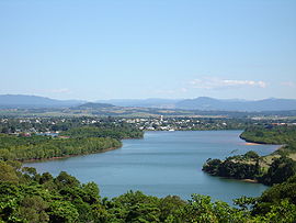
 The township of Innisfail, as seen from Coquette Point | |||||||||||||||
| Coordinates | 17.5238°S 146.0311°E / -17.5238; 146.0311 (Innisfail (town centre)) | ||||||||||||||
| Population |
| ||||||||||||||
| • Density | 703/km2 (1,820/sq mi) | ||||||||||||||
| Established | 1882/83[3][4] | ||||||||||||||
| Postcode(s) | 4860 | ||||||||||||||
| Elevation | 10 m (33 ft)[5] | ||||||||||||||
| Area | 10.3 km2 (4.0 sq mi) | ||||||||||||||
| Time zone | AEST (UTC+10:00) | ||||||||||||||
| Location |
| ||||||||||||||
| LGA(s) | Cassowary Coast Region | ||||||||||||||
| State electorate(s) | Hill | ||||||||||||||
| Federal division(s) | Kennedy | ||||||||||||||
| |||||||||||||||
| |||||||||||||||
Innisfail is the major township of the Cassowary Coast Region and is known for its sugar and banana industries, as well as for being one of Australia's wettest towns. In March 2006, Innisfail gained worldwide attention when severe Tropical Cyclone Larry passed over causing extensive damage.[8][9]
Oops something went wrong:
