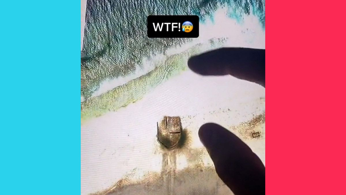
What is on Starbuck Island? This was the question that came to mind when millions of people watched a new video in July 2021. The TikTok video showed a person zooming into Starbuck Island on Google Earth, ending with a purported strange discovery. The island is located in the Pacific Ocean.
The Video
The TikTok video was posted by @hidden.on.google.earth. The account is one of several that specialize in posting videos about interesting finds made in satellite pictures and Google Street View photographs.
The person zoomed into Starbuck Island on Google Earth and displayed the letters "WTF" upon finding something on the beach.
"What is this," the person asked. There appeared to be a road or trench-like path that led to some sort of object or man-made structure. The video was viewed more than 5 million times in just two days.
TikTok Commenters Make Guesses
One of the TikTok users who responded to the Starbuck Island Google Earth video joked that it showed the Millennium Falcon from "Star Wars." Another person remarked: "That's how they delivered pizzas in the old days."
Additional guesses from commenters included Noah's Ark, a rock, a UFO, a Blockbuster Video, and an old runway from World War II.
Others joked that maybe it was a Starbucks Coffee location.
The Real Answer
While the jokes may have been funny and the video was slightly mysterious, the answer was less than thrilling.
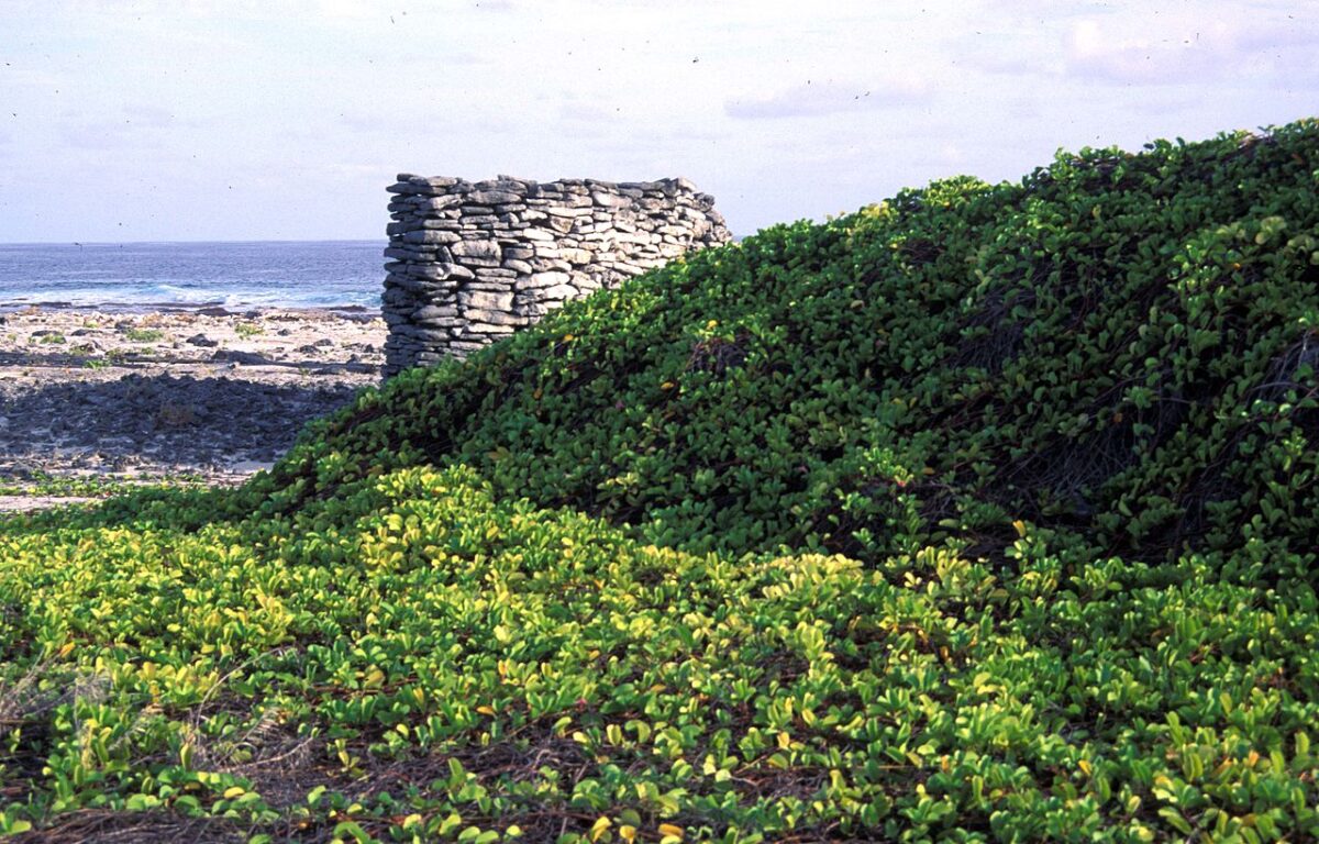
In 2009, National Geographic published two YouTube videos about Dr. Enric Sala and "members of the Ocean Now team becoming stranded on Starbuck Island during an on-shore excursion." At the 0:36 mark in the video, old dwellings are visible near the beach, explaining the Google Earth mystery.
https://www.youtube.com/watch?v=k2HpEk3RRUc&t=36s
One of the camera angles seen in the video can be compared to a satellite picture to confirm that it does, indeed, show the dwellings.
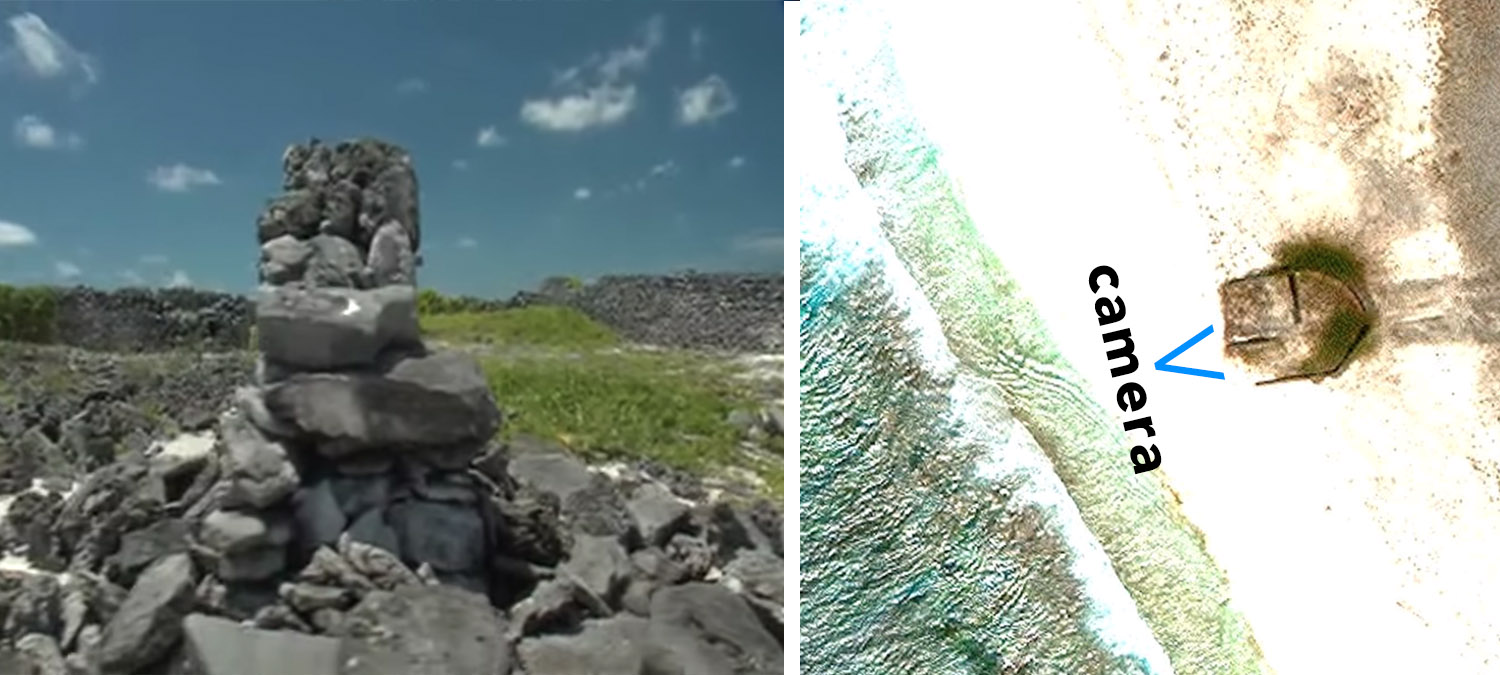
The structures that remain were purportedly featured in a photograph on Wikimedia Commons.
National Geographic also posted a second video to show the outcome of the problem presented in the first clip. According to the videos, the only trees on the island were palm trees "planted by long-gone workers."
Starbuck Island History
According to The Honolulu Star-Advertiser, Starbuck Island is part of the Line Islands in Kiribati. It's located 336 miles south of the equator and 2,000 miles south of Honolulu, Hawaii. The island measures about eight square miles and rises only 15 feet above sea level. It has seabirds, a green turtle nesting area, sharks, and manta rays.
In 1823, it was discovered by a Nantucket sailing captain named Valentine Starbuck. The island is reportedly "famous for its shipwrecks." "The guano was mined for phosphate in the 19th century," the newspaper reported.
There's no relation between Starbuck Island and the Starbucks Coffee Company. According to the Star-Advertiser, "the coffee is named after a character in 'Moby Dick' (Captain Ahab's first mate)." However, "both the fictional first mate and the real captain came from Nantucket, where Starbuck was a family name in the 19th century."
Shipwrecks
We found a number of accounts of shipwrecks on Starbuck Island, although no remnants of the long-ago disasters were visible on Google Earth.
For example, San Francisco's newspaper The Daily Examiner reported on Jan. 25, 1887, that one shipwrecked crew had to basically draw straws to see who would be able to live or potentially die.
Perils of the Sea
Loss of the Bark Diana and the Fate of a Portion of the Crew
The Melbourne Argus of December 20th says: The three-masted schooner Jerfalcon, which arrived yesterday from Maldon Island, brought as passengers Captain Myers, the first and second mates, and three men of the bark Diana, which was wrecked on August 11th through striking a reef in the vicinity of Starbuck Island.
From information supplied by Captain Myers, it appears that the Diana was loaded by Pope & Talbot of San Francisco and left Puget sound July 12th, bound for Sydney with a cargo of lumber.
Moderately fine weather was experienced until August 9th, when at midnight the weather suddenly changed to the eastward, accompanied by heavy rain and squalls, and thick, drizzling weather.
At about 2:15 o'clock the following morning, the vessel struck on a reef. Captain Myers had a raft constructed and by that means the crew reached the shore, and made the necessary arrangements by means of lines to land the others, which was ultimately done, and it was then found that the vessel had struck on a reef in the neighborhood of the east side of Starbuck Island.
On September 21st, Captain Myers and all hands started for Maldon Island. The boats proved to be too deeply laden, however, and as the seas washed over them repeatedly, a return was made to Starbuck Island on September 25th.
As the boats were unequal to the conveyance of the entire crew, it was decided to cast lots as to who should remain and who should leave. The question was settled by means of paper slips, and the two boats, with four men in each, started once more for Maldon Island on October 12th.
The attempt was not more successful than the one made previously. After being reduced to great straits for water, a course was shaped for Manahiki, or Humphreys Island.
To their great relief, the island was sighted, and a landing safely effected. There are about 500 inhabitants on the island who subsist chiefly on coconuts and fish.
The shipwrecked crew were unaware that the island was inhabited, and were agreeably surprised by the kind treatment shown them by the natives.
According to the rest of the story, a ship was sent to go retrieve the other crew who were left on the Starbuck Island. They were left with a number of provisions including "120 pounds of bread, 60 pounds of flour, 40 pounds of barley, 20 pounds of coffee, 30 pounds of tinned meats, and a quantity of beef and pork." Their fate was not documented in the 1887 article.
The story ended by reporting about one of the crew that landed on Manahiki Atoll (formerly Humphrey's Island). "One of the crew at the Humphrey's Island cast in his lot with the natives there and took one of them [as his] wife."
Aside from the Starbuck Island Google Earth video, we've reported on a number of satellite image finds and Google Street View discoveries in the past. For example, there was the time a body was purportedly found on Google Maps, a story about zombies being spotted, and even a "super rabbit" hit by a Google Street View car.