Cascade Range
Last updated| Cascade Range | |
|---|---|
| Cascade Mountains (in Canada) "The Cascades" | |
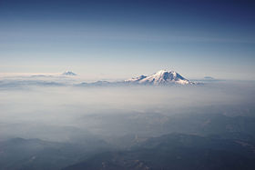 The Cascades in Washington, with Mount Rainier, the range's highest mountain, standing at 14,411 ft (4,392 m). Seen in the background (left to right) are Mount Adams, Mount Hood, and Mount St. Helens. | |
| Highest point | |
| Peak | Mount Rainier, Washington |
| Elevation | 14,411 ft (4,392 m) NAVD 88 [1] |
| Listing | |
| Coordinates | 46°51′10″N121°45′38″W / 46.8528267°N 121.7604408°W [2] |
| Dimensions | |
| Length | 700 mi (1,100 km)north-south |
| Width | 80 mi (130 km) |
| Area | 150,000 km2 (58,000 sq mi) |
| Geography | |
| Countries | United States and Canada |
| Provinces/States | British Columbia, Washington, Oregon, and California |
The Cascade Range or Cascades is a major mountain range of western North America, extending from southern British Columbia through Washington and Oregon to Northern California. It includes both non-volcanic mountains, such as many of those in the North Cascades, and the notable volcanoes known as the High Cascades. The small part of the range in British Columbia is referred to as the Canadian Cascades or, locally, as the Cascade Mountains. The highest peak in the range is Mount Rainier in Washington at 14,411 feet (4,392 m).
Contents
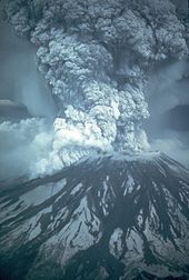
The Cascades are part of the Pacific Ocean's Ring of Fire, the ring of volcanoes and associated mountains around the Pacific Ocean. All of the eruptions in the contiguous United States over the last 200 years have been from Cascade volcanoes. The two most recent were Lassen Peak from 1914 to 1921 and a major eruption of Mount St. Helens in 1980. Minor eruptions of Mount St. Helens have also occurred since, most recently from 2004 to 2008. [3] The Cascade Range is a part of the American Cordillera, a nearly continuous chain of mountain ranges (cordillera) that form the western "backbone" of North, Central, and South America.
The Cascades are home to many national parks and protected areas, including North Cascades National Park, Mount Rainier National Park, Crater Lake National Park, and Lassen Volcanic National Park. The northern half of the Pacific Crest Trail follows the range.
Geography
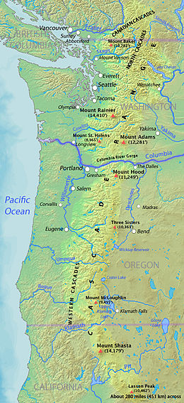
The Cascades extend northward from Lassen Peak (also known as Mount Lassen) in northern California to the confluence of the Nicola and Thompson rivers in British Columbia. The Fraser River separates the Cascades from the Coast Mountains in Canada, [4] as does the Willamette Valley from the upper portion of the Oregon Coast Range. The highest volcanoes of the Cascades, known as the High Cascades, [5] dominate their surroundings, often standing twice the height of the nearby mountains. They often have a visual height (height above nearby crestlines) of one mile or more. The highest peaks, such as the 14,411-foot (4,392 m) Mount Rainier, dominate their surroundings for 50 to 100 miles (80 to 161 km).
The northern part of the range, north of Mount Rainier, is known as the North Cascades in the United States but is formally named the Cascade Mountains north of the Canada–United States border, reaching to the northern extremity of the Cascades at Lytton Mountain. [6] Overall, the North Cascades and Canadian Cascades are extremely rugged; even the lesser peaks are steep and glaciated, and valleys are quite low relative to peaks and ridges, so there is great local relief. [7] The southern part of the Canadian Cascades, particularly the Skagit Range, is geologically and topographically similar to the North Cascades, while the northern and northeastern parts are less glaciated and more plateau-like, resembling nearby areas of the Thompson Plateau. [4]
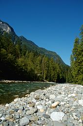
The range is near the Pacific Ocean and in the region's prevailing westerly winds, so it receives significant rain and snowfall, especially on the western slopes due to orographic lift, with annual snow accumulations of up to 1,000 inches (2,500 cm) (= 83 feet (25 m)) in some areas. Mount Baker in Washington recorded a national record single-season snowfall in the winter of 1998–99 with 1,140 inches (2,900 cm) (= 95 feet (29 m)). [8] Before that year, Mount Rainier held the American record for snow accumulation at Paradise in 1978. It is not uncommon for some places in the Cascades to have over 500 inches (1,300 cm) of annual snow accumulation, such as at Lake Helen, near Lassen Peak. [9] Most of the High Cascades are therefore white with snow and ice year-round. The western slopes are densely covered with Douglas-fir (Pseudotsuga menziesii), western hemlock (Tsuga heterophylla) and red alder (Alnus rubra), [10] while the drier eastern slopes feature mostly ponderosa pine (Pinus ponderosa), with some western larch (Larix occidentalis), mountain hemlock (Tsuga mertensiana) and subalpine fir (Abies lasiocarpa) and subalpine larch (Larix lyallii) at higher elevations. [11] Annual rainfall is as low as 9 inches (230 mm) on the eastern foothills due to a rain shadow effect. [12]
Beyond the eastern foothills is an arid plateau that was largely formed 17 to 14 million years ago by the many flows of the Columbia River Basalt Group. Together, these sequences of fluid volcanic rock form the 200,000-square-mile (520,000 km2) Columbia Plateau in eastern Washington, Oregon, and parts of western Idaho. [13]
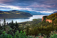
The Columbia River Gorge is the only major break of the range in the United States. When the Cascades began to rise 7 million years ago in the late Miocene, the Columbia River drained the relatively low Columbia Plateau. As the range grew, erosion from the Columbia River was able to keep pace, carving out the gorge and major pass seen today. The gorge also exposes uplifted and warped layers of basalt from the plateau. [14] [15]
History
Before European exploration, First Nations tribes named many peaks, including "Wy'east" for Mount Hood, [16] "Seekseekqua" for Mount Jefferson (Oregon), [16] "M'laiksini Yaina" for Mount McLoughlin, [16] "Tahoma", the Lushootseed name for Mount Rainier, [17] , and "Louwala-Clough", meaning "smoking mountain" for Mount St. Helens. [18]
In early 1792, British navigator George Vancouver explored Puget Sound and gave English names to the high mountains he saw. Mount Baker was named for Vancouver's third lieutenant, Joseph Baker, although the first European to see it was Manuel Quimper, who named it la gran montaña del Carmelo ("Great Mount Carmel") in 1790. [19] Mount Rainier was named after Admiral Peter Rainier. Later in 1792, Vancouver had his lieutenant William Robert Broughton explore the lower Columbia River. He named Mount Hood after Lord Samuel Hood, an admiral of the Royal Navy. Mount St. Helens was sighted by Vancouver in May 1792, from near the mouth of the Columbia River. It was named for Alleyne FitzHerbert, 1st Baron St Helens, a British diplomat. [20] Vancouver's expedition did not, however, name the mountain range which contained these peaks. He referred to it simply as the "eastern snowy range". Earlier Spanish explorers called it Sierra Nevada, meaning "snowy mountains". [19]
In 1805, the Lewis and Clark Expedition passed through the Cascades on the Columbia River, which for many years was the only practical way to pass that part of the range. They were the first non-indigenous people to see Mount Adams, but they thought it was Mount St. Helens. When they later saw Mount St. Helens they thought it was Mount Rainier. [21] On their return trip, Lewis and Clark spotted a high but distant snowy pinnacle that they named for the sponsor of the expedition, U.S. President Thomas Jefferson. [22] Lewis and Clark called the Cascade Range the "Western Mountains". [23]
The Lewis and Clark expedition, and the many settlers and traders that followed, met their last obstacle to their journey at the Cascades Rapids in the Columbia River Gorge, a feature on the river now submerged beneath the Bonneville Reservoir. Before long, the great white-capped mountains that loomed above the rapids were called the "mountains by the cascades" and later simply as the "Cascades". The earliest attested use of the name "Cascade Range" is in the writings of botanist David Douglas in 1825. [24] [25]

In 1814, Alexander Ross, a fur trader with the North West Company, seeking a viable route across the mountains, explored and crossed the northern Cascades between Fort Okanogan and Puget Sound. His report of the journey is vague about the route taken. He followed the lower Methow River into the mountains. He might have used Cascade Pass to reach the Skagit River. Ross was the first European-American to explore the Methow River area and likely the first to explore the Stehekin River and Bridge Creek region. Due to the difficulty of crossing the northern Cascades and the paucity of beaver, fur-trading companies made only a few explorations into the mountains north of the Columbia River after Ross. [26]
Exploration and settlement of the Cascades region by Europeans and Americans was accelerated by the establishment of a major trading post of the Hudson's Bay Company (HBC) at Fort Vancouver near today's Portland, Oregon. From this base HBC trapping parties traveled throughout the Cascades in search of beaver and other fur-bearing animals. For example, using what became known as the Siskiyou Trail, Hudson's Bay Company trappers were the first non-natives to explore the southern Cascades in the 1820s and 1830s, establishing trails which passed near Crater Lake, Mount McLoughlin, Medicine Lake Volcano, Mount Shasta, and Lassen Peak. [27]
The course of political history in the Pacific Northwest saw the spine of the Cascade Range being proposed as a boundary settlement during the Oregon Dispute of 1846. The United States rejected the proposal and insisted on the 49th parallel north, which cuts across the range just north of Mount Baker. Throughout the period of dispute and up to the creation of the Crown Colony of British Columbia in 1858, the Hudson's Bay Company's York Factory Express route, as well the route of fur brigades, followed the Okanogan River along the east edge of the Cascades and the Columbia River through the range. Passes across the range were not well known and little used. Naches Pass was used for driving cattle and horses to Fort Nisqually. Yakima Pass was also used by the Hudson's Bay Company. [28]
American settlement of the flanks of the Coast Range did not occur until the early 1840s, at first only marginally. Following the Oregon Treaty the inward flux of migration from the Oregon Trail intensified and the passes and back-valleys of what is now the state of Washington were explored and populated, and it was not long after that railways followed. Despite its being traversed by several major freeways and rail lines, and its lower flanks subjected to major logging in recent decades, large parts of the range remain intense and forbidding alpine wilderness. Much of the northern half of the Cascades, from Rainier north, have been preserved by U.S. national or British Columbia provincial parks (such as E.C. Manning Provincial Park), or other forms of protected area. [29]
The Canadian side of the range has a history that includes the Fraser Canyon Gold Rush of 1858–60 and its famous Cariboo Road, as well as the older Hudson's Bay Company Brigade Trail from the Canyon to the Interior, the Dewdney Trail, and older routes which connected east to the Similkameen and Okanagan valleys.
The southern mainline of the Canadian Pacific Railway penetrated the range via the passes of the Coquihalla River, along one of the steepest and snowiest routes in the entire Pacific Cordillera. Near Hope, B.C., the railway roadbed and the Othello Tunnels, now decommissioned, are popular tourist recreation destinations for hiking and bicycling. The pass is used by the Coquihalla Highway, a government megaproject built as part of the Expo 86 spending boom of the 1980s, which is now the main route from the Coast to the British Columbia interior. Traffic formerly went via the Fraser Canyon, to the west, or via Allison Pass and Manning Park along Highway 3 to the south, near the border.
The Barlow Road was the first established land path for U.S. settlers through the Cascade Range in 1845, and formed the final overland link for the Oregon Trail (previously, settlers had to raft down the treacherous rapids of the Columbia River). The Road left the Columbia at what is now Hood River and passed along the south side of Mount Hood at what is now Government Camp, terminating in Oregon City. There is an interpretive site there now at "The End of The Oregon Trail". The road was constructed as a toll road – $5 per wagon – and was very successful.
In addition, the Applegate Trail was created to allow settlers to avoid rafting down the Columbia River. The Trail used the path of the California Trail to north-central Nevada. From there, the Trail headed northwest into northern California, and continued northwest towards today's Ashland, Oregon. From there, settlers would head north along the established Siskiyou Trail into the Willamette Valley.
With the exception of the 1915 eruption of remote Lassen Peak in Northern California, the range was quiet for more than a century. Then, on May 18, 1980, the dramatic eruption of Mount St. Helens shattered the quiet and brought the world's attention to the range. Geologists were also concerned that the St. Helens eruption was a sign that long-dormant Cascade volcanoes might become active once more, as in the period from 1800 to 1857 when a total of eight erupted. None have erupted since St. Helens, but precautions are being taken nevertheless, such as the Cascades Volcano Observatory and Mount Rainier Volcano Lahar Warning System in Pierce County, Washington. [30]
Geology

The Cascade Range is made up of a band of thousands of very small, short-lived volcanoes that have built a platform of lava and volcanic debris. Rising above this volcanic platform are a few strikingly large volcanoes, like Mount Hood and Mount St. Helens, that dominate the landscape. [31]
The Cascade volcanoes define the Pacific Northwest section of the Ring of Fire, an array of volcanoes that rim the Pacific Ocean. The Ring of Fire is also known for its frequent earthquakes. The volcanoes and earthquakes arise from a common source: subduction, where the dense Juan de Fuca oceanic plate plunges beneath the North American Plate. [32] As the oceanic slab sinks deep into the Earth's interior beneath the continental plate, high temperatures and pressures allow water molecules locked in the minerals of solid rock to escape. The water vapor rises into the pliable mantle above the subducting plate, causing some of the mantle to melt. This newly formed magma rises toward the Earth's surface to erupt, forming a chain of volcanoes (the Cascade Volcanic Arc) above the subduction zone. [32]
Human uses
Soil conditions for farming are generally good, especially downwind of volcanoes. This is largely because volcanic rocks are often rich in potassium-bearing minerals such as orthoclase, and erode relatively easily. Volcanic debris, especially lahars, also helps to spread mineral-rich volcanic material, and the storage of water in the form of snow and ice is also important for agriculture. The snow-capped mountains, such as Mt. Hood and Mt. Bachelor, are used as ski resorts in the late winter, while in the summer they become popular hiking and mountaineering locations. Much of their meltwater eventually flows into reservoirs, where it is used for recreation, while its potential energy is captured to generate hydroelectric power before the water is used to irrigate crops.
Because of the abundance of powerful streams, many of the major westward-draining rivers of the Cascades have been dammed to provide hydroelectric power. One of these, Ross Dam on the Skagit River, retains a reservoir which spans the border southeast of Hope, British Columbia, extending 2 miles (3.2 km) into Canada. At the foot of the southeast flank of Mount Baker, at Concrete, Washington, the Baker River is dammed to form Lake Shannon and Baker Lake.
The Cascades harbor a largely-untapped potential for geothermal power. The U.S. Geological Survey Geothermal Research Program has been investigating this potential. Some of this energy is already being used in places like Klamath Falls, Oregon, where volcanic steam is used to heat public buildings. [33] The highest recorded underground temperature found in the range is 510 °F (266 °C) at 3,075 feet (937 m) below Newberry Volcano's caldera floor.
Ecology
Forests of large, coniferous trees (western red cedars, Douglas-firs, western hemlocks, firs, pines, spruces, and others) dominate most of the Cascade Range. Cool, wet winters and warm, dry summers (largely a result of oceanic influence) favor evergreen species, whereas mild temperatures and rich soils promote fast and prolonged growth. [34] [35]

As a traveler passes through the Cascade Range, the climate first gets colder, then warmer and drier east of the crest. [36] Most of the Cascades' lower and middle elevations are covered in coniferous forest; the higher altitudes have extensive meadows as well as alpine tundra and glaciers. The southern part of the Cascades are within the California Floristic Province, an area of high biodiversity.[ citation needed ]
Silver fir predominates above 2500 ft, while there are moors, meadows, and mountain hemlock/subalpine fir groves from 4500 to 6000 ft on the west side. The treeline is at ~6000 feet. On the east side, subalpine forests of larch trees grade to pine and interior fir forests below 4200 ft, which grade to ponderosa below 2500 ft, which in turn grades to semidesert scrub near sea level. Above 7500 ft, the landscape is barren with either no plants or only moss and lichen. [37]
Black bears, coyotes, bobcats, cougars, beavers, deer, elk, moose, mountain goats and a few wolf packs returning from Canada live in the Cascades. Fewer than 50 grizzly bears reside in the Cascades of Canada and Washington. [38]
See also
Related Research Articles

Mount St. Helens is an active stratovolcano located in Skamania County, Washington, in the Pacific Northwest region of the United States. It lies 52 miles (83 km) northeast of Portland, Oregon, and 98 miles (158 km) south of Seattle. Mount St. Helens takes its English name from that of the British diplomat Alleyne Fitzherbert, 1st Baron St Helens, a friend of explorer George Vancouver who surveyed the area in the late 18th century. The volcano is part of the Cascade Volcanic Arc, a segment of the Pacific Ring of Fire.

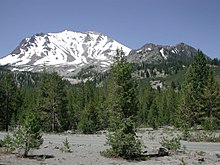
Lassen Volcanic National Park is an American national park in northeastern California. The dominant feature of the park is Lassen Peak, the largest plug dome volcano in the world and the southernmost volcano in the Cascade Range. Lassen Volcanic National Park is one of the few areas in the world where all four types of volcanoes can be found: plug dome, shield, cinder cone, and stratovolcano.

Lassen Peak, commonly referred to as Mount Lassen, is a lava dome volcano and the southernmost active volcano in the Cascade Range of the Western United States. Located in the Shasta Cascade region of Northern California, it is part of the Cascade Volcanic Arc, which stretches from southwestern British Columbia to northern California. Lassen Peak reaches an elevation of 10,457 ft (3,187 m), standing above the northern Sacramento Valley. It supports many flora and fauna among its diverse habitats, which are subject to frequent snowfall and reach high elevations.

Mount Adams, known by some Native American tribes as Pahto or Klickitat, is a potentially active stratovolcano in the Cascade Range. Although Adams has not erupted in more than 1,000 years, it is not considered extinct. It is the second-highest mountain in Washington, after Mount Rainier.

Glacier Peak or Dakobed is the most isolated of the five major stratovolcanoes of the Cascade Volcanic Arc in the U.S state of Washington. Located in the Glacier Peak Wilderness in Mount Baker–Snoqualmie National Forest, the volcano is visible from the west in Seattle, and from the north in the higher areas of eastern suburbs of Vancouver such as Coquitlam, New Westminster and Port Coquitlam. The volcano is the fourth tallest peak in Washington state, and not as much is known about it compared to other volcanoes in the area. Local Native Americans have recognized Glacier Peak and other Washington volcanoes in their histories and stories. When American explorers reached the region, they learned basic information about surrounding landforms, but did not initially understand that Glacier Peak was a volcano. Positioned in Snohomish County, the volcano is only 70 miles (110 km) northeast of downtown Seattle. From locations in northern Seattle and northward, Glacier Peak is closer than the more famous Mount Rainier (Tahoma), but as Glacier Peak is set farther into the Cascades and almost 4,000 feet (1,200 m) shorter, it is much less noticeable than Mount Rainier.

The North Cascades are a section of the Cascade Range of western North America. They span the border between the Canadian province of British Columbia and the U.S. state of Washington and are officially named in the U.S. and Canada as the Cascade Mountains. The portion in Canada is known to Americans as the Canadian Cascades, a designation that also includes the mountains above the east bank of the Fraser Canyon as far north as the town of Lytton, at the confluence of the Thompson and Fraser Rivers.

Indian Heaven is a volcanic field in Skamania County in the state of Washington, in the United States. Midway between Mount St. Helens and Mount Adams, the field dates from the Pleistocene to the early Holocene epoch. It trends north to south and is dominated by six small shield volcanoes; these shields are topped by small spatter and cinder cones, and the field includes a number of subglacial volcanoes and tuyas. The northernmost peak in the field is Sawtooth Mountain and the southernmost is Red Mountain; its highest point is Lemei Rock at an elevation of 5,925 feet (1,806 m).

Goat Rocks is an extinct stratovolcano in the Cascade Range, located between Mount Rainier and Mount Adams in southern Washington, in the United States. Part of the Cascade Volcanoes, it was formed by the subduction of the Juan de Fuca Plate under the western edge of the North American Plate. The volcano was active from 3.2 million years ago until eruptions ceased between 1 and 0.5 million years ago. Throughout its complex eruptive history, volcanism shifted from silicic explosive eruptions to voluminous, mafic activity.

Larch Mountain is an extinct volcano near Portland, Oregon. The name is misleading, as no western larch can be found there. It received that name when early lumbermen sold the noble fir wood as larch. The peak can be reached between May and November on paved Larch Mountain Road, 16 mi (26 km) east of Corbett, Oregon, although the road is closed during the winter and spring months. The road leading to Larch Mountain from the Historic Columbia River Highway is 14 miles long, which closed at milepost 10 from Nov. through late May or early June due to snow.

The Cascade Volcanoes are a number of volcanoes in a volcanic arc in western North America, extending from southwestern British Columbia through Washington and Oregon to Northern California, a distance of well over 700 miles (1,100 km). The arc formed due to subduction along the Cascadia subduction zone. Although taking its name from the Cascade Range, this term is a geologic grouping rather than a geographic one, and the Cascade Volcanoes extend north into the Coast Mountains, past the Fraser River which is the northward limit of the Cascade Range proper.

Yamsay Mountain is a large shield volcano in the Cascade Range of south-central Oregon, located about 35 miles (56 km) east of Crater Lake on the border between Klamath County and Lake County. It is part of the Cascade Volcanic Arc but is located in a mountain range 30 to 50 miles behind the main Cascade volcanic front. The best known members of this enigmatic arc are the massive shields of Newberry Volcano, about 55 miles (89 km) farther north in Oregon, and Medicine Lake Volcano, about 80 miles (130 km) south in Northern California. Yamsay is the highest volcano in the eastern arc, almost 300 feet (90 m) higher than Newberry and Medicine Lake.

The geology of the Pacific Northwest includes the composition, structure, physical properties and the processes that shape the Pacific Northwest region of North America. The region is part of the Ring of Fire: the subduction of the Pacific and Farallon Plates under the North American Plate is responsible for many of the area's scenic features as well as some of its hazards, such as volcanoes, earthquakes, and landslides.

The Cascades ecoregion is a Level III ecoregion designated by the United States Environmental Protection Agency (EPA) in the U.S. states of Washington, Oregon, and California. Somewhat smaller than the Cascade mountain range for which it is named, the ecoregion extends north to Snoqualmie Pass, near Seattle, and south to Hayden Pass, near the Oregon-California border, including the peaks and western slopes of most of the High Cascades. A discontiguous section is located on Mount Shasta in California.
Trout Creek Hill is a small Pleistocene basaltic shield volcano in Washington, United States. Located in Skamania County, Trout Creek Hill rises to an elevation of 2,946 feet (898 m). It is part of the Cascade Volcanic Arc, located in the Marble Mountain-Trout Creek Hill volcanic field.

Mount Rainier, also known as Tahoma, is a large active stratovolcano in the Cascade Range of the Pacific Northwest in the United States. The mountain is located in Mount Rainier National Park about 59 miles (95 km) south-southeast of Seattle. With a summit elevation of 14,411 ft (4,392 m), it is the highest mountain in the U.S. state of Washington, the most topographically prominent mountain in the contiguous United States, and the tallest in the Cascade Volcanic Arc.

Jumbo Peak is a 5,801 ft (1,770 m) volcanic mountain summit located in the Gifford Pinchot National Forest, in Skamania County of Washington state. It is situated in the Cascade Range, 15 mi (24 km) northwest of Mount Adams, 20 mi (32 km) east-northeast of Mount St. Helens, and 38 mi (61 km) south of Mount Rainier. Its nearest higher neighbor is Sunrise Peak, 1.7 mi (2.7 km) to the north-northeast. Precipitation runoff from Jumbo Peak drains into tributaries of the Cowlitz River drainage basin. The Juniper Ridge Trail (#261) which skirts this peak provides access to this remote peak.

Sunrise Peak is a prominent 5,892 ft (1,800 m) volcanic mountain summit located in the Gifford Pinchot National Forest, in Skamania County of Washington state. It is situated in the Cascade Range, 15.7 mi (25.3 km) northwest of Mount Adams, 21 mi (34 km) northeast of Mount St. Helens, and 36 mi (58 km) south of Mount Rainier. Its nearest higher neighbor is Burnt Rock, 12.2 mi (19.6 km) to the southeast, and Jumbo Peak lies 1.7 mi (2.7 km) to the south-southwest. Precipitation runoff from Sunrise Peak drains into tributaries of the Cowlitz River drainage basin. The Sunrise Trail (#262) and Juniper Ridge Trail provide access to this remote peak, with minor scrambling at the summit.
The Cascade-Sierra province is a physiographic region of mountains in the western United States, east and adjacent to Pacific Border province and west and adjacent to the Basin and Range Province and Columbia Plateau Province.
Spiral Butte is a cinder cone in Yakima County, Washington in the United States. The summit and most of the slopes are located within the William O. Douglas Wilderness of the Okanogan–Wenatchee National Forest between White Pass and Rimrock Lake. Historically the mountain has also been referred to as Big Peak. The present name stems from its orientation with a lava flow extending north out of the cone before spiraling east and then south. US 12 runs along the southern slope of the butte.
References
- Citations
- ↑ "Topographic map of Mount Rainier". opentopomap.org. Retrieved 2023-05-08.
- ↑ "Mount Rainier". Geographic Names Information System . United States Geological Survey, United States Department of the Interior . Retrieved 2023-05-08.
- ↑ "Mount St. Helens: 2004–2008 Renewed Volcanic Activity". Cascades Volcano Observatory. U.S. Geological Survey. February 7, 2013. Archived from the original on April 28, 2015. Retrieved November 9, 2013.
- 1 2 Beckey 2008, pp. 191–200.
- ↑ Martin 2002, p. 31.
- ↑ Duffell & McTaggart 1951, p. 8.
- ↑ Beckey 2003, pp. 9–12.
- ↑ "National Climate Extremes". National Oceanic and Atmospheric Administration. Archived from the original on June 6, 2012.
- ↑ McLaughlin, Mark (October 14, 2010). "Weather Window: The snowiest spot in California is Lake Helen near Lassen Volcanic National Park". Sierra Sun. Truckee, California. Retrieved November 9, 2013.
- ↑ Beckey 2008, p. 16.
- ↑ Mueller & Mueller 2002, p. 99.
- ↑ Ernst 2000, p. 479.
- ↑ Straub, Kristen; Link, Paul. "Columbia River Basalt Province". Digital Geology of Idaho. Idaho State University. Archived from the original on October 23, 2013. Retrieved November 3, 2013.
- ↑ Harrison, John (October 31, 2008). "Columbia River Gorge". Columbia River History. Northwest Power and Conservation Council. Retrieved November 9, 2013.
- ↑ "The Cascade Episode: Evolution of the Modern Pacific Northwest". Burke Museum of Natural History and Culture, University of Washington. Retrieved November 9, 2013.
- 1 2 3 Hale, Jamie (17 May 2019), "The native names of Pacific Northwest mountains", The Oregonian, retrieved 25 October 2021
- ↑ "Mount Rainier, Washington". Naming the Cascade Range Volcanoes. U.S. Geological Survey. Retrieved April 23, 2012.
- ↑ "Northwest Legends". Mount St. Helens Volcano, Washington. U.S. Geological Survey. Archived from the original on May 10, 2012.
- 1 2 Beckey 2003, pp. 3–7.
- ↑ "Naming the Cascade Range Volcanoes: Mount St. Helens, Washington". U.S. Geological Survey. Retrieved June 15, 2012.
- ↑ Beckey 2003, pp. 38–39.
- ↑ "The Volcanoes of Lewis and Clark, Mount Jefferson, Oregon". U.S. Geological Survey. Retrieved June 15, 2012.
- ↑ Beckey 2003, p. 28.
- ↑ Beckey 2003, p. 48.
- ↑ Majors, Harry M. (1975). Exploring Washington. Van Winkle Publishing Co. p. 150. ISBN 978-0-918664-00-6.
- ↑ Beckey 2003, pp. 41–45.
- ↑ "Museum of the Siskiyou Trail". Archived from the original on April 15, 2012.
- ↑ Beckey 2003, pp. 63–64, 98.
- ↑ "North Cascades Ecoregion". Land Scope America. Retrieved June 15, 2012.
- ↑ "Pilot Project – Mount Rainier Volcano Lahar Warning System". Volcano Hazards Program. U.S. Geological Survey. Archived from the original on May 11, 2008.
- ↑
 This article incorporates public domain material from Pacific – Cascades Volcanic Province. United States Geological Survey.
 - 1 2 This article incorporates public domain material from Pacific – Cascades Volcanic Province. United States Geological Survey.
- ↑ "Geothermal Utility". City of Klamath Falls. Archived from the original on October 6, 2010.
- ↑ This article incorporates public domain material from "Pacific Northwest" (PDF). Status and Trends of the Nation's Biological Resources.
- ↑ Waring, RH; Franklin, JF (1979). "Evergreen coniferous forests of the Pacific Northwest". Northwest Science. 204 (4400): 1380–1386. Bibcode:1979Sci...204.1380W. doi:10.1126/science.204.4400.1380. PMID 17814182. S2CID 28313427.
- ↑ "Ecoregions of Western Washington and Oregon" (PDF). U.S. Environmental Protection Agency. Archived from the original (PDF) on 2017-05-25. Retrieved November 4, 2013.
- ↑ "Life Zones in Washington".
- ↑ Rice, Nathan (November 14, 2011). "The forgotten North Cascades grizzly bear". High Country News. Paonia, Colorado.
- Sources
- Beckey, Fred W. (2003). Range of Glaciers: the Exploration and Survey of the Northern Cascade Range. Portland, Oregon: Oregon Historical Society Press. ISBN 978-0-87595-243-7.
- Beckey, Fred W. (2008). Cascade Alpine Guide: Climbing and High Routes Rainy Pass to Fraser River. Seattle, Washington: The Mountaineers Books. ISBN 978-1-59485-136-0.
- Duffell, Stanley; McTaggart, Kenneth Cunningham (1951). Ashcroft Map-Area, British Columbia. Memoir (Geological Survey of Canada). Vol. 262. Ottawa, Ontario: Natural Resources Canada; E. Cloutier, King's Printer. OCLC 3333133.
- Dzurisin, Dan; Stauffer, Peter H.; Hendley, James W. II (2000) [1997]. Living With Volcanic Risk in the Cascades. U.S. Geological Survey.
- Ernst, Wallace Gary (2000). Earth Systems: Processes and Issues. Cambridge, England: Cambridge University Press. ISBN 978-0-521-47323-1.
- Harris, Stephen L. (2005). Fire Mountains of the West: The Cascade and Mono Lake Volcanoes (3rd ed.). Missoula, Montana: Mountain Press Publishing Company. ISBN 978-0-87842-511-2.
- Holland, Stuart S. (1976). Landforms of British Columbia: A Physiographic Outline (Bulletin 48). British Columbia Department of Mines and Petroleum Resources. Archived from the original on May 4, 2005.
- Martin, James (2002). North Cascades Crest: Notes and Images from America's Alps . Seattle, Washington: Sasquatch Books. ISBN 978-1-57061-140-7.
- Mueller, Marge; Mueller, Ted (2002). Exploring Washington's Wild Areas (2nd ed.). Seattle, Washington: The Mountaineers Books. ISBN 978-0-89886-807-4.
- Wood, Charles A.; Kienle, Jürgen, eds. (1990). Volcanoes of North America. Cambridge, England: Cambridge University Press. ISBN 978-0-521-43811-7.
External links
 Media from Commons
 Texts from Wikisource
 Travel information from Wikivoyage
- Central and Southern Cascades Forests images at bioimages.vanderbilt.edu
- Eastern Cascades Forests images at bioimages.vanderbilt.edu
- Cascade Mountains Leeward Forests images at bioimages.vanderbilt.edu
- British Columbia Mainland Coastal Forests images at bioimages.vanderbilt.edu
- University of Washington Libraries Digital Collections – Dwight Watson Photographs
| International | |
|---|---|
| National | |
| Other | |
Text is available under the CC BY-SA 4.0 license; additional terms may apply.
Images, videos and audio are available under their respective licenses.