


Bizarre, Enormous 16th-Century Map Assembled for First Time
The largest known world map of its time—made of 60 individual sheets—can finally be seen as the mapmaker intended.
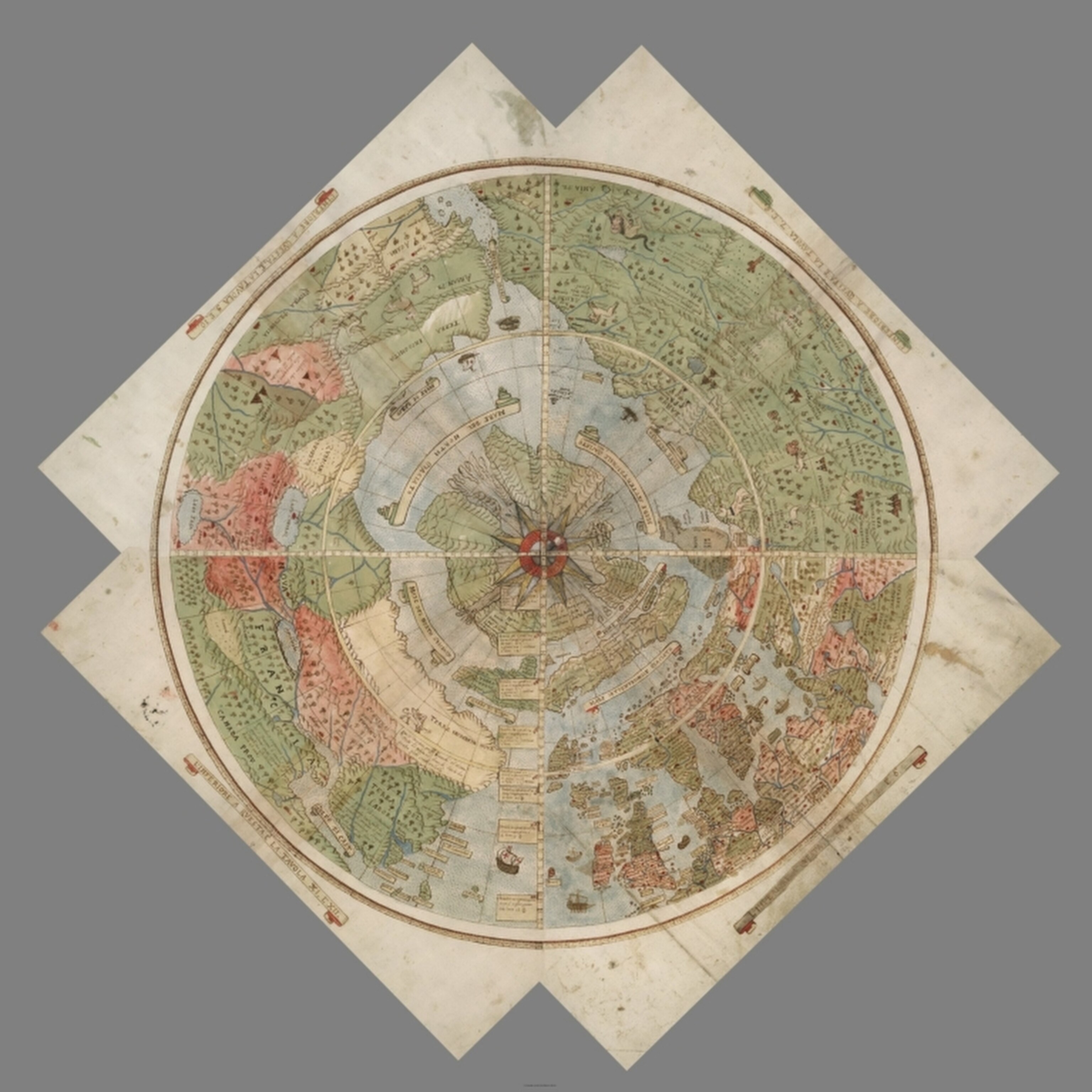
This colorful and intricately detailed map from 1587 is more than nine feet by nine feet when fully assembled. For the last 430 years, its 60 individual sheets were bound together as an atlas, but now they have finally been put together—digitally—to reveal a complete picture of the world as it was understood at the time.
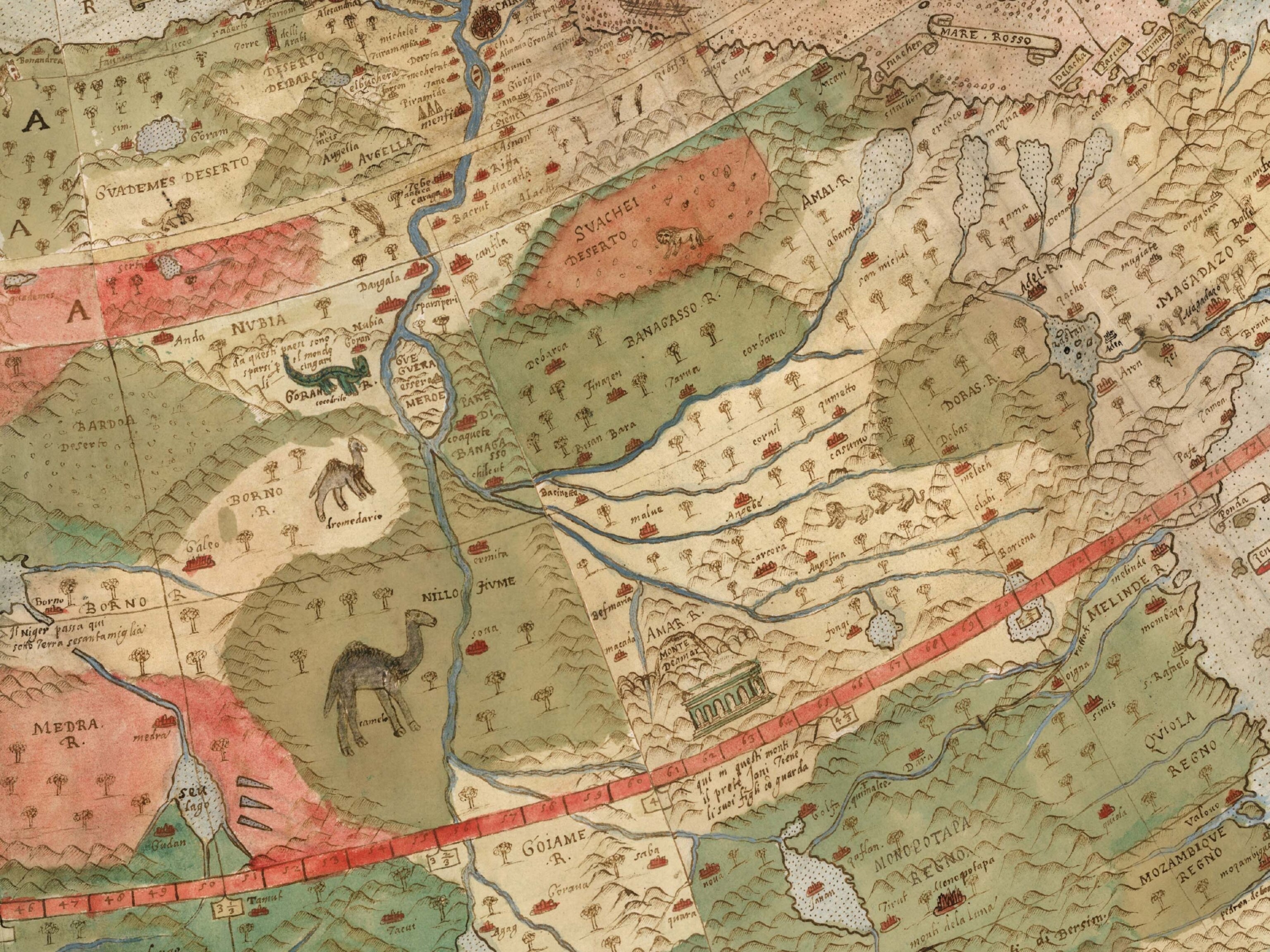
And what a world it was. The map is packed with fantastical creatures, from unicorns in Siberia to mermen frollicking in the Southern Ocean and a terrifying bird flying off with an elephant in its talons. The map reflects the geographical knowledge (and misconceptions) of its time, but in some ways it’s surprisingly advanced. It portrays the Earth as it would be seen looking directly down on the North Pole from space, a perspective not commonly used by mapmakers until the 20th century.
“It’s unique in many ways,” says G. Salim Mohammed, the head and curator of the David Rumsey Map Center at Stanford University, which recently added the map to its collection. “No one has really studied this because it’s been hidden for centuries.” Only three surviving versions of the map are known to exist.
THE MAN BEHIND THE MAP

Little is known about the mapmaker, Urbano Monte. He came from a wealthy and well-connected family in Milan, and like many gentleman scholars of his day, he had a keen interest in geography. It was, after all, an exciting age of discovery, writes Katherine Parker, a historian of cartography, in a recent essay about Monte’s map: “Their world was growing each day and Monte wanted to understand all of it.”
Monte appears to have been quite geo-savvy for his day. He drew on the works of more famous cartographers like Gerardus Mercator and Abraham Ortelius, and he included recent discoveries of his time, such as the islands of Tierra del Fuego at the tip of South America, first sighted by the Portuguese explorer Ferdinand Magellan in 1520.
Thanks to his connections in high places, Monte met with the first official Japanese delegation to visit Europe when they came to Milan in 1585. Perhaps as a result, his depiction of Japan contains many place names that don’t appear on other Western maps of the time.
Like many mapmakers of the era, Monte had a tendency to fill in the empty spaces on his map. Animals roam the land, and his oceans teem with ships and monsters. King Philip II of Spain rides what looks like a floating throne off the coast of South America, a nod to Spanish prominence on the high seas.

A more unusual feature of Monte’s map, however, is the projection—that is, the method he uses to flatten the globe onto a map. Monte’s map is circular, with the North Pole at the center and lines of longitude radiating outward from there—what modern cartographers call a polar azimuthal projection, a very unusual choice for his time. The projection became popular only with the advent of air travel in the 20th century, when the shortest route between two points often involved arcing up over the Arctic (here’s one example).
“I think Monte was really trying to show the circular nature of the Earth,” says David Rumsey, the map collector who bought the map and donated it to the center he founded last year at Stanford. The polar projection has the advantage of accurately portraying the continents of the northern hemisphere. It grossly exaggerates the size of Antarctica, but that actually fit with the cartographic thinking of the time, Rumsey says. “Most cartographers thought it had to be massive to counterbalance the large landmasses to the north,” he says—a misguided but influential idea dating back to the ancient Greeks.
BRINGING MONTE’S VISION TO LIFE
Rumsey purchased the Monte map in September, and his nephew Brandon did most of the work to scan each page and stitch the images together. They fit almost perfectly, which suggests it’s what Monte had intended all along. The individual sheets and composite are now online, as is a version of the map aligned with the modern globe in Google Earth:
Using modern technology to fulfill the vision of a 16th century cartographer is exactly the sort of thing the new map center at Stanford was set up to do, say Rumsey and Mohammed. Making the new digital version freely available should make it easier for scholars to learn more about Monte and his map. For the rest of us, it’s a chance to explore an extremely rare map that happens to be one of the most spectacular of its time.
If you’re interested in ancient maps, check out our post on why mapmakers invented things to fill the empty spaces. For more about David Rumsey and Stanford’s cutting-edge map center, see our post about its opening.
Follow All Over the Map on Twitter and Instagram.
Related Topics
You May Also Like


Go Further
Animals
- What La Palma's 'lava tubes' tell us about life on other planetsWhat La Palma's 'lava tubes' tell us about life on other planets
- This fungus turns cicadas into zombies who procreate—then dieThis fungus turns cicadas into zombies who procreate—then die
- How can we protect grizzlies from their biggest threat—trains?How can we protect grizzlies from their biggest threat—trains?
- This ‘saber-toothed’ salmon wasn’t quite what we thoughtThis ‘saber-toothed’ salmon wasn’t quite what we thought
- Why this rhino-zebra friendship makes perfect senseWhy this rhino-zebra friendship makes perfect sense
Environment
- What La Palma's 'lava tubes' tell us about life on other planetsWhat La Palma's 'lava tubes' tell us about life on other planets
- How fungi form ‘fairy rings’ and inspire superstitionsHow fungi form ‘fairy rings’ and inspire superstitions
- Your favorite foods may not taste the same in the future. Here's why.Your favorite foods may not taste the same in the future. Here's why.
- Are the Great Lakes the key to solving America’s emissions conundrum?Are the Great Lakes the key to solving America’s emissions conundrum?
- The world’s historic sites face climate change. Can Petra lead the way?The world’s historic sites face climate change. Can Petra lead the way?
History & Culture
- Hawaii's Lei Day is about so much more than flowersHawaii's Lei Day is about so much more than flowers
- When treasure hunters find artifacts, who gets to keep them?When treasure hunters find artifacts, who gets to keep them?
- Meet the original members of the tortured poets departmentMeet the original members of the tortured poets department
- When America's first ladies brought séances to the White HouseWhen America's first ladies brought séances to the White House
Science
- Should you be concerned about bird flu in your milk?Should you be concerned about bird flu in your milk?
- Here's how astronomers found one of the rarest phenomenons in spaceHere's how astronomers found one of the rarest phenomenons in space
Travel
- Are Italy's 'problem bears' a danger to travellers?Are Italy's 'problem bears' a danger to travellers?
- How to navigate Nantes’ arts and culture scene
- Paid Content
How to navigate Nantes’ arts and culture scene - This striking city is home to some of Spain's most stylish hotelsThis striking city is home to some of Spain's most stylish hotels
- Photo story: a water-borne adventure into fragile AntarcticaPhoto story: a water-borne adventure into fragile Antarctica
