2016 U.S. presidential election mapped
This post may contain affiliate links. As an Amazon Associate, we earn from qualifying purchases.
The 2016 U.S. presidential election was the 58th quadrennial presidential election, held on Tuesday, November 8, 2016. The Republican ticket of businessman Donald Trump and Indiana Governor Mike Pence won the Democratic ticket of former Secretary of State Hillary Clinton and U.S. Senator from Virginia Tim Kaine.
While Hillary Clinton got about 2.9 million more votes general, a margin of 2.1 percent of the total cast, Donald Trump conquered supremacy in the Electoral College, winning 30 U.S. states with 306 pledged electors out of 538, and reversed the permanent swing states of Florida, Ohio, and Iowa, as well as the “blue wall” of Michigan, Wisconsin, and Pennsylvania, which had been Democratic citadels in presidential elections since the 1990s. Donald Trump’s winning was predicted dubious by most media forecasts.
On December 19, there were 7 dubious electors; 2 defected from Donald Trump while 5 defected from Hilary Clinton. Three other Clinton electors tried to defect but were changed or ordered to vote again due to their particular state laws. Finally, Donald Trump received 304 electoral votes, and Hillary Clinton got 227, while Colin Powell won 3, and John Kasich, Ron Paul, Bernie Sanders, and Faith Spotted Eagle each got one.
Donald Trump became the 5th person in U.S. history to become president of the United States, notwithstanding losing the national popular vote. He is the 1st president without any previous public service experience, while Clinton was the 1st woman to be a major American party’s presidential candidate.
The maps below shows results of the 2016 U.S. presidential elections.


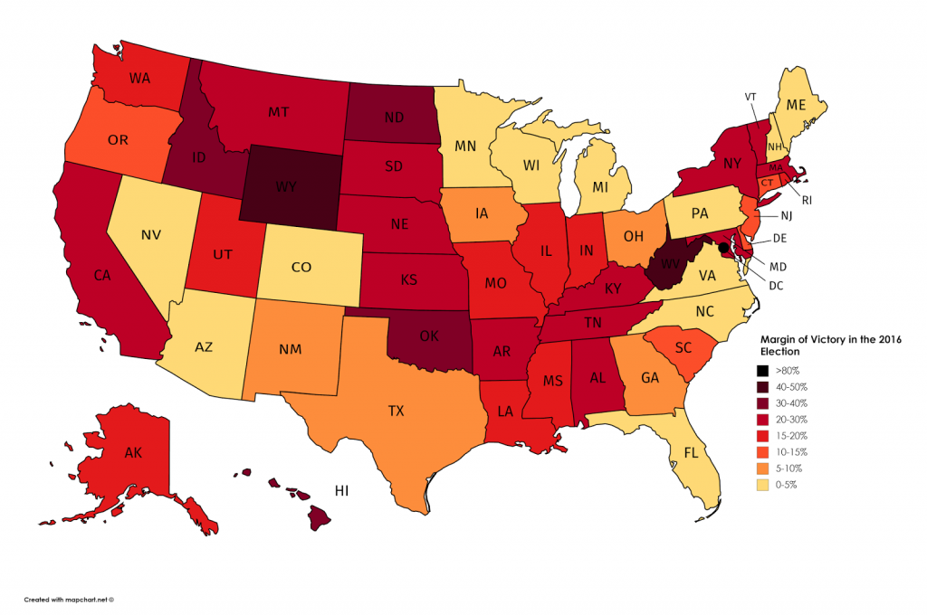
The map below shows the margin of victory in the 2016 Presidential Election by the U.S. state.

Most vividly, the election results are illustrated by the map “Trumpland and Clinton archipelago”.
Related posts:
– U.S. presidential election results in two maps (2016)
– Change in margin between 2004 & 2016 elections
– The power of small U.S. states
– 3D map of county-level election results
– Geographically approximate, population-normalized 2016 voting results using congressional districts
– Hex map of U.S. electoral votes
– Contribution of each popular vote to electoral vote outcome, in number of persons, by U.S state
– U.S. states by victors of both primaries and the presidential election (2016)
– The Clinton Archipelago and Trump’s America
– U.S. counties in which party of top vote-getter changed between 2000 & 2016 presidential elections
– U.S. Presidential Election 2016 (Cartogram)
– How America voted in every election (1824 – 2016)
– The fewest counties in the fewest states required to win the U.S. presidential election
– If “Did Not Vote” was a candidate in 2016, it would have won by a landslide
– The America That Never Wanted Hillary To Be President
– Red Shift: Change in Democratic vote share in presidential election (2012 – 2016)
– Wisconsin election results by county (2008 – 2016)
– Where each candidate outperformed election forecasts
– U.S. Presidential Election (2016)
– How the presidential election of 2016 would look like if only millennials voted
– Electoral Map Upon Trump’s Victory
– Every United States presidential elections (1788 – 2016)
– The vote across the Mexican border
– White Vote in the 2016 U.S. Election

United States presidential election
You might want to look at Utah’s 3rd party candidates results again. The map has it completely wrong. From a quick glance, it looks like Gary Johnson finished 4th in each county. Evan McMullen beat Hillary Clinton in several counties and finished 2nd or 3rd in each. https://www.politico.com/2016-election/results/map/president/utah/
Very cool representation of the results.
Beautiful map. Can see how certain influences might change outlook in the future. Although will have new constraints.
It’s positive that our fore fathers realized how the big cities with the most population could control the election. Thank you for the good sense to have the electoral college. This is a Republic we live in not a Democracy. Quote: Benjamin Franklin. “A democracy is 2 wolves and 1 lamb looking for lunch. Who will be the lunch?” The corruption must stop especially at the voting polls.