
2020 Aegean Sea earthquake
 The partially collapsed Doğanlar Apartment where 15 people died.[1] | |
 | |
| UTC time | 2020-10-30 11:51:26 |
|---|---|
| ISC event | 619514791 |
| USGS-ANSS | ComCat |
| Local date | 30 October 2020 |
| Local time | 14:51 TRT (UTC+3)[2] |
| Duration | 16 seconds[3] |
| Magnitude | 7.0 Mw[4] |
| Depth | 16.1 km (10.0 mi)[4] |
| Epicentre | 37°55′05″N 26°47′24″E / 37.918°N 26.790°E East Aegean Sea |
| Type | Normal |
| Areas affected | Turkey, Greece |
| Total damage | > $400 million |
| Max. intensity | MMI VIII (Severe) |
| Peak acceleration | 0.98 g |
| Tsunami | 5.6–6 m (18–20 ft) |
| Foreshocks | Three months prior |
| Aftershocks | 2,800+ recorded |
| Casualties | 119 dead, 1,053 injured, 15,000 homeless[5][6] |
An earthquake with a moment magnitude of 7.0[4][note 1] occurred on 30 October 2020 about 14 km (8.7 mi) northeast of the Greek island of Samos. Although Samos was closest to the epicentre, it was the Turkish city İzmir, 70 km (43 mi) northeast that was heavily affected—more than 700 residential and commercial structures were seriously damaged or destroyed. One hundred and seventeen people died in İzmir Province while an additional 1,034 were injured.[9][10] In Greece, there were two fatalities and 19 injured.[11] The earthquake is the deadliest in the year 2020, and the third major earthquake to strike Turkey that year. The event is called the Samos earthquake by the International Seismological Centre.[4]
Tectonic setting[edit]

The Aegean Sea is a seismically active region with complex plate tectonics interaction both within and surrounding the Aegean Sea Plate. The region has several major plate boundary including the North Anatolian Fault which runs through northern Turkey, where the Anatolian Plate slides past the Eurasian Plate along this right-lateral strike-slip fault. Another major boundary is the East Anatolian Fault where the Arabian Plate interacts with the Anatolian Plate. This transform fault was responsible for the 2020 Elazığ earthquake.[12]
At its southern edge, the African Plate converges north towards the Aegean Sea Plate at a rate of 5–10 mm (0.20–0.39 in)/yr. It subducts beneath the Aegean, occasionally producing great megathrust earthquakes and tsunamis including the 365 Crete earthquake. The subduction rate along the Hellenic subduction zone at 35 mm (1.4 in)/yr, however, greatly exceeds the velocity of the African Plate. North-south extension within the Aegean Sea Plate in the back-arc region compensate the subduction rate. Shallow crustal earthquakes within the Aegean Sea Plate is a result of this extension, accommodated by east-west trending normal faults.[13]
Historical seismicity[edit]
The first record of an earthquake in the Samos and İzmir region date back to 200 BC, describing an earthquake of magnitude 6.0–6.5, and intensity VII–VIII. Another earthquake with an estimated magnitude of 7.0 struck the region in 47 AD.[14] On the island of Samos, these earthquakes have minimal effects. However, nearby Izmir have suffered serious catastrophe as a result of these earthquakes. The most destructive event in the region was the 1688 Smyrna earthquake, which had an epicentre near İzmir.[15] With an estimated magnitude 7.0, the earthquake killed 15,000–20,000 people in the city.[16] Other major events took place in 1739 and 1788, causing major damage in the city.[17] On 11 August 1904, Samos was rocked by a magnitude 6.8 earthquake, causing substantial damage in Greece and Turkey, and killing four people.[18] That earthquake according to researchers, was caused by an onshore fault (Pythagorion Fault) on the island.[19]
Earthquake[edit]
The earthquake was the result of normal faulting at a shallow crustal depth within the Aegean Sea Plate in the eastern Aegean Sea, about 250 km (160 mi) north of the closest plate boundary, the Hellenic Trench, where the African Plate moves north at a rate of approximately 10 mm (0.39 in)/yr with respect to the Eurasian Plate. Due to its geological setting away from a plate boundary, it is considered an intraplate earthquake. A focal mechanism analysis indicated that the earthquake occurred on a moderately dipping normal fault striking either eastward or westward. This mechanism indicates north-south oriented extension that is common in the Aegean Sea. The United States Geological Survey stated that normal faulting events of this size typically have a fault area of 50 km (31 mi) x 20 km (12 mi).[20]
The North Samos Fault, also known as the Kaystrios Fault, is an east–west striking, north–northeast dipping normal fault located offshore, north of the coast of Samos.[14] The fault was previously determined to have the potential to produce an earthquake of magnitude 6.8.[21][22] It likely ruptured entirely during the earthquake for a length of approximately 60 km (37 mi).[23][18] The epicentral location suggests it was on the western extension of the geologically active Büyük Menderes Graben.[24] The earthquake released a seismic moment of 3.3 × 10¹⁹ N-m, corresponding to a moment magnitude of 7.0. A maximum slip of 4.6 m (15 ft) at a depth of 7 km (4.3 mi) was inferred.[25][24] The earthquake produced up to 1 m (3 ft 3 in) of slip on the seafloor, causing a moderate tsunami, and tectonic uplift and subsidence on land.[26]
Strong ground motion[edit]
.jpg)
| Modified Mercalli intensities in selected locations[14] | |
| MMI | Locations |
|---|---|
| MMI VIII (Severe) | Samos |
| MMI VI (Strong)–MMI VII (Very strong) | Gümüldür Atatürk, Kuşadası, Seferihisar, Sığacık, Bayraklı |
| MMI V (Moderate) | Balıklıova, Manisa |
| MMI IV (Light) | Sarıkemer |
The earthquake achieved a peak ground acceleration (pga) of 0.27 g in Samos. Weaker ground acceleration was recorded at 0.1 g in İzmir, however, in the Bayraklı and Karşıyaka metropolitan districts, these ground motions were amplified with longer periods of 1.5 seconds.[17][14] Ground motions were severely amplified in these districts due to the soil condition consisting of loose sediments.[27] In the Turkish town of Kuşadası, the pga was 0.18 g. At 22.27 km (13.84 mi) away from the epicentre, on Turkish soil, the highest pga was recorded 0.98 g.[28] The maximum intensity was recorded on Samos Island, VIII (Severe), a revision from X (Extreme).[29][30] Shaking was also felt on the Greek island of Crete, and in some regions of Athens.[31]
Foreshocks and aftershocks[edit]
The earthquake was preceded by a foreshock sequence consisting of 39 events over a period of three months.[32]
As of 8 November, over 2,800 aftershocks have been recorded.[33] The mainshock may have been preceded by a foreshock on 5 May the same year.[34]
| Date and time (UTC) | Location | M | MMI | Ref |
|---|---|---|---|---|
| 30 October, 12:19:09 | 5 km NW of Marathókampos, Greece | 4.4 | – | [35] |
| 30 October, 12:41:31 | 4 km N of Samos, Greece | 4.0 | V | [36] |
| 30 October, 13:00:43 | 8 km N of Kokkári, Greece | 4.9 | – | [37] |
| 30 October, 15:14:55 | 8 km NW of Kokkári, Greece | 5.3 | VI | [38] |
| 30 October, 15:19:15 | 2 km SW of Samos, Greece | 4.8 | – | [39] |
| 30 October, 17:16:03 | 7 km NE of Samos, Greece | 4.2 | – | [40] |
| 30 October, 19:09:40 | 17 km NE of Agios Kirykos, Greece | 4.2 | – | [41] |
| 30 October, 22:53:22 | 9 km NNE of Néon Karlovásion, Greece | 4.1 | – | [42] |
| 31 October, 01:40:33 | 19 km WNW of Néon Karlovásion, Greece | 4.2 | – | [43] |
| 31 October, 05:31:30 | 10 km NNW of Kokkári, Greece | 4.9 | III | [44] |
| 31 October, 12:36:20 | 5 km W of Kokkári, Greece | 4.2 | – | [45] |
| 31 October, 14:42:43 | 26 km WNW of Néon Karlovásion, Greece | 4.3 | III | [46] |
| 31 October, 22:05:43 | 4 km NNE of Kokkári, Greece | 4.0 | – | [47] |
| 1 November, 07:05:13 | 9 km NNE of Samos, Greece | 4.2 | – | [48] |
| 1 November, 07:33:08 | 1 km NNE of Kokkári, Greece | 4.2 | – | [49] |
| 1 November, 12:57:03 | 2 km NNW of Kokkári, Greece | 4.4 | – | [50] |
| 2 November, 11:58:03 | 5 km NNE of Kokkári, Greece | 4.3 | III | [51] |
| 2 November, 12:30:39 | 20 km SSW of Seferihisar, Turkey | 4.4 | II | [52] |
| 2 November, 19:16:40 | 19 km WNW of Néon Karlovásion, Greece | 4.5 | – | [53] |
| 3 November, 20:35:35 | 22 km WNW of Néon Karlovásion, Greece | 4.0 | – | [54] |
| 4 November, 13:21:31 | 6 km ENE of Megálo Chorió, Greece | 4.2 | – | [55] |
| 9 November, 20:31:00 | 12 km NNE of Kokkári, Greece | 4.3 | II | [56] |
| 11 November, 06:49:45 | 9 km NE of Kokkári, Greece | 4.6 | IV | [57] |
| 12 November, 03:34:15 | 9 km WSW of Kokkári, Greece | 4.4 | – | [58] |
| 4 December, 09:34:16 | 7 km ENE of Néon Karlovásion, Greece | 4.5 | – | [59] |
| 30 December, 13:40:13 | 7 km ENE of Agios Kirykos, Greece | 4.1 | III | [60] |
| 20 January, 23:37:57 | 10 km NNE of Néon Karlovásion, Greece | 4.8 | V | [61] |
Tsunami[edit]
Tsunami information was issued by the Kandilli Observatory Earthquake Monitoring and Tsunami Warning Center to the Earthquake Research Department of Turkey approximately 11 minutes after the earthquake, but was not broadcast to the coastal regions. The tsunami arrived between 10 and 15 minutes after the mainshock.[22]
Multiple social media posts showed water rushing through streets and ports in the region following the earthquake, along with tsunami warnings being issued for the islands of Ikaria, Kos, Chios and Samos.[62] Flooding from the coasts reached heights of 1.9 m (6 ft 3 in), however at Akarca, the tsunami reached heights of 6 m (20 ft).[63] In Azmak, the tsunami penetrated 1.3 km (0.81 mi) inland, 0.82 km (0.51 mi) in Akarca, and 0.32 km (0.20 mi) in Sigacik. Recorded heights of the tsunami from this event were larger than those of other similar magnitude earthquakes in the same region with the exception of the 1956 Amorgos earthquake.[63]
Damage to buildings caused by the tsunami in Greece and Turkey was moderate and non-structural. The tsunami produced unusually long basin oscillations, persisting for over a day after the earthquake. The earthquake itself generated an unusually large tsunami for its magnitude and normal focal mechanism.[64]
Turkish coast[edit]
In Akarca, north of Samos, the tsunami run-up heights were up to 3.8 m (12 ft), reaching as far as 290 m (950 ft) inland. The maximum wave height in this area was 6 m (20 ft).[63] A 2.2 m (7 ft 3 in) surge flooded and damaged a diving center near the coast. Garden walls and fences of homes at the shore were also damaged. Cars and boats were among the large objects picked up by the surge and moved inland. The only known tsunami fatality was reported in this town.[65][66]
In Alaçatı on the Çeşme Peninsula, the tsunami flowed up a stream and inundated inland by as much as 2.49 km (1.55 mi). It carried a fishing vessel 1.16 km (0.72 mi) inland along the stream during the inundation. Analysis of video footage on the coast showed that the tsunami had a maximum height of 1.7 m (5 ft 7 in) when it struck.[32]
East of Alaçatı is Zeytineli, where the tsunami severely damaged unoccupied resort houses along a stretch of beach. Debris from damaged structures were strewn along the beach. Concrete blocks were also displaced by as much as 25 m (82 ft). A maximum inundation of 760 m (2,490 ft) was measured, as well as a flow height of 1.9 m (6 ft 3 in) at a palm tree, 50 m (160 ft) from the shore.[32]
At Sığacık, a wave struck the coast with a run-up height of 5.0–5.6 m (16.4–18.4 ft). The tsunami waves where higher in this region due to the geometry of the coast; the presence of a shallow bay.[67]
Greek coast[edit]
On the island of Samos, the tsunami caused major flooding on its northern coast, and was recorded by multiple people on video camera. No deaths were reported by the tsunami.[68] Many offices and businesses were immediately flooded when the surge broke through windows and doors. Waves of 1.5–2.0 m (4 ft 11 in – 6 ft 7 in) traveled as far as 101 meters inland. Damage to boats and cars were widely reported in the aftermath.[69] A number of small boats and cars were carried inland or lost at sea by the tsunami. Some boats were smashed along breakwater structures as well. Shops, hotel lobbies, restaurants, offices and homes suffered slight damage when the tsunami inundated the ground level and indoors. A maximum run-up height of 3.35 m (11.0 ft) was measured on the northern coast of Samos about 5.8 km (3.6 mi) east of Karlovasi Port.[64] The tsunami caused some material damage to a home that was located at the coast.[69]
Geological effects[edit]
The earthquake produced significant coseismic uplift on the island of Samos. Surface ruptures were also observed on the island. The beaches, ports, and coasts of Samos were partially raised in the aftermath. At Karlovasi, up to 24 cm (9.4 in) of permanent uplift was measured at a breakwater off the coast. Approximately 1.5 km (0.93 mi) west of Karlovasi is the Akra coast consisting of marble, which was raised 20 cm. Between 15 cm (5.9 in) and 20 cm (7.9 in) of uplift was measured at Ayios Nikolaos, located 12 km (7.5 mi) southwest of the epicentre. An aftershock measuring Mw 4.5 on 20 January 2021 generated 8–10 cm (3.1–3.9 in) of additional uplift in the same area. Similar measurements were taken at a marina in Marathokampos. The Pythagoreio Fault in Pythagoreio, 29 km (18 mi) southeast of the earthquake, generated 29 cm (11 in) of surface deformation during the quake. An estimated uplift of 25 cm (9.8 in) is thought to have occurred at Potokaki as reported by tourists.[70] According to the Earth Applied Sciences Disasters Program of NASA, synthetic-aperture radar data revealed Samos Island was raised by as much as 10 cm (3.9 in) meanwhile its northern coast subsided by the same amount. The ground uplift and subsidence pattern suggested a coseismic rupture along a fault located north of the island, dipping at an angle towards the north.[71]
Small normal-mechanism surface ruptures were documented near the villages of Kontakaiika, Ayios Nikolaos, and Ayios Elias. Vertical displacements of up to 8 cm (3.1 in) were observed on the ground, and across roads. The coseismic surface ruptures resulted in some damage to roads and brick walls. Although these uplifts were on the order of several centimeters, it added up to a length of 1 km (0.62 mi).[70]
Small landslides, rockfalls and slope failures were reported along fault scarps on Samos. Some instances of rockfalls caused minor traffic disruption when they partially blocked roads. A small rockfall caused slight damage to an adjacent building in Kokkari.[70] Ground cracks appeared on a road at Malagari. The cracked caused part of the road, and small trees to slide several centimeters closer to the shore as a result of lateral spreading. Minor liquefaction occurred at the beach near the town as well.[70]
Impact[edit]
.jpg)
Overall, minor damage occurred on Samos despite its close proximity to the epicentre. Most of the damage and casualties were from the Bornova and Bayraklı districts of İzmir; located at least 70 km (43 mi) north of the epicentre.[73] On 4 November, the mayor of İzmir, Tunç Soyer, stated that 15,000 people in the city were made homeless.[74] Total damage is estimated to be in the millions for Greece, and over $400 million for Turkey.[75] Serious structural damage and pancake-style building collapses caused many deaths in Izmir.
Greece[edit]
Greek authorities from Samos stated that although buildings were damaged across the island, the worst sustained was in Karlovasi,[76] where a large church had partially collapsed. In Karlovasi, over 100 buildings were damaged upon inspection.[77] It was the first time since 2017 that there are earthquake-related fatalities in Greece.[78]
On-site inspections of buildings on the island began hours after the quake, and ended on 15 November. Of the 4,245 buildings inspected, 57 percent were declared unsafe for inhabitation. At least 87 percent of damaged buildings were of masonry construction while 6 percent were of reinforced concrete types. Damage mostly consisted of partial collapse or shear cracks. Churches and other religious buildings suffered significant but repairable damaged in the quake. Archeological sites and items of historical value were damaged, some of which beyond repair. At the Archaeological Museum of Pythagorion, vessels and sculptures were destroyed. The parameter wall of the Castle of Lycurgus Logothetis suffered partial collapses. A crack appeared in the marble structure of the Archaeological Museum of Vathy.[14]
Turkey[edit]

Initially, Turkish Minister of the Interior Süleyman Soylu stated that at least six buildings were destroyed in İzmir, but the city's mayor Tunç Soyer later put the number of collapsed buildings closer to 20.[62] On-site investigations by the Turkish Ministry of Environment and Urbanization revised the number of collapsed and intentionally demolished buildings to 103. At least 700 other buildings suffered serious damage, and in 814, damage was moderate. Slight structural damage was reported in across 7,889 buildings, while the other 159,000 were unaffected.[79]
Collapse apartments accounted for nearly all 117 deaths in Turkey. Among the deadliest collapse involved the Rıza Bey Apartment, where 38 people including 11 children died.[80]
Most of the buildings that collapsed were built in the 1990s, based on outdated earthquake regulations from 1975. Poor construction practices and the absence of code compliance were reasons for the collapse.[81] The buildings that totally failed were typically between 5–10 storeys tall, and at least 30 years old.[82] Additionally, the first floors of these buildings were altered for commercial use such as shops. Taller buildings with heights of 100–240 m (330–790 ft), however, did not sustain structural damages. The city is also built on soft sediments in a basin which amplified the intensity of shaking despite its distance from the epicentre.[83]
It is believed that the effects of basin amplification worsened the intensity of ground motions, causing structural failures. The observation of damage effects and instrumental data found that ground motions were amplified 2.5–3 times in the İzmir basin.[82]
Casualties[edit]

One hundred and seventeen (117) people were killed and 1,034 were injured in Turkey, all but one in the city of Izmir.[9] The other Turkish victim outside Izmir died from drowning in the advancing tsunami in the district of Seferihisar. It was the first recorded tsunami fatality in Turkey.[3] Additionally, two teenagers died in Greece after being crushed by a wall on the island of Samos; 19 others were injured in Greece.[6]
Relief operations[edit]

Immediately after the earthquake, Turkish Minister of Health Fahrettin Koca stated that about 40 ambulances, 35 emergency rescue teams and two ambulance helicopters had reached the affected region,[84] while Turkey's Ministry of National Defence stated that one of its planes had departed from Etimesgut Air Base to transport AFAD and gendarmerie teams to the scene.[85] The Turkish Red Crescent immediately deployed teams from six cities to provide food to those affected by the earthquake.[86] More than 1,200 workers were involved in rescue efforts involving at least 13 buildings in İzmir,[62] which continued into the night. According to Al Jazeera, the personnel involved in the rescue operations had reached about 8,000, including 25 search and rescue dogs.[87][88] Turkish authorities stated that 106 people were rescued, while the local government had set up tents to house about 2,000 people overnight. On 3 November, a three-year-old girl was rescued from an eight-story building—a toddler was rescued after being trapped in another building for 65 hours a day before.[89][90] A total of 17 collapsed buildings were part of the search and rescue operations, according to Mehmet Gulluoglu, head of Turkey's Disaster and Emergency Management Presidency (AFAD).[91]
Criminal investigation[edit]

Following the deadly 1999 İzmit earthquake which claimed 17,000 lives, Turkey has stepped-up its measures on building codes in respond to earthquakes. Codes have enabled increase the safety of newer buildings during seismic events[92] An earthquake tax was established that same year to make infrastructures more resistant to earthquakes.[93]
Among the residential apartments which suffered structural damage was the Yılmaz Erbek Apartment located in the Bayraklı metropolitan district. The 10-storey apartment partially collapsed, destroying the first few floors, killing 11 residents and injuring another 11. An investigation by the İzmir Chief Public Prosecutor's Office found that poor construction materials and practices, and the lack of inspections led to its collapse. During renovation works in the 2000s, the ground floor was renovated for a supermarket. Seven of the nine workspaces in the first floor were combined, which meant columns were deliberately cut to make space for the supermarket. An exterior wall of the structure was also torn down for a window.[94] A total of five indictments were filed against 29 individuals; 10 of whom have been imprisoned. Several public officials were also accused of neglect of duty in the role of the collapse.[95]
Another four individuals were involved in a lawsuit for their roles in the collapse of the Doğanlar Apartment that killed 15 and injured 12. Two of the accused were detained by authorities for "causing the death and injury of more than one person by conscious negligence", and could face jail time of up to 20 years.[96] Officials also arrested individuals involved in the construction of the Rıza Bey Apartment.[97]
International reactions[edit]
Countries:
 United States
- The US embassy has shared their condolences for the dead and wounded in the earthquake.[98]
- The NASA analysed satellite imagery and worked with the Turkish Space Agency and several universities in the affected region.[99]
 Germany – The German embassy in Ankara has shared the following message from Twitter "After the earthquake in Izmir, our thoughts are with the victims and their relatives. Get well soon, Izmir!".
 Albania – The Albanian ambassador Kastriot Robo said "Where are with our friends in this hard time".[100]
 Australia – The Australian ambassador to Turkey Marc Innes-Brown shared his condolences and said the following "After the earthquake in Izmir, our thoughts are with the victims and their relatives. Get well soon, Izmir!".
 Indonesia – General Chairperson of the Indonesian Red Cross and Former Vice President of Indonesia Jusuf Kalla shared his condolences and he said he was ready to send Indonesian Red Cross volunteers to Turkey to help evacuate earthquake victims if needed.[101]
 Azerbaijan
- The Azerbaijani President İlham Aliyev called the Turkish President Recep Tayyip Erdoğan. He said that he was sorry and they were prepared to offer aid.[100]
- The President of the National Parliament of Azerbaijan Sahibe Gafarova shared his condolences with his counterpart Mustafa Sentop.[100]
 United Kingdom – The ambassador of UK Dominick Chilcott shared his condolences and said the following "The United Kingdom as always, will be in the side with Turkey".[100]
 Denmark – The Danish ambassador Danny Annan, shared his condolences and said the following "I wish my condolences to the relatives of those who lost their lives and a speedy recovery for their benefits.".
 France – French Minister of İnternal Affairs Gérald Darmanin, has said that France was ready to offer support to Greece and Turkey.[102]
 Israel – Israeli Minister of Defense Benny Gantz said that they were ready to assist Turkey by sending a search and rescue team and a field hospital.[100]
 Qatar
Qatar
- Embassy of Qatar said the following "Due to the Earthquake that happened in Izmir we share our condolences with the Turkish Government and to our Turkish brothers".
- A Disaster Information Management Centre was set up in Izmir by the Qatar Red Crescent Society.[103]
 Kazakhstan
- The President of the Kazak Parliament Nurlan Nigmatulin, "Stating that we stand by the brotherly Turkish people and share their grief in this tragic moment, I express my urgent healing wishes to the wounded. I wish you patience and fortitude of the people of Turkey."[104]
- Kazakh Minister of Foreign Affairs Mukhtar Tleuberdi, sent the following message to his counterpart Mevlüt Çavuşoğlu, "I offer my deepest condolences to the bereaved families who lost their relatives by sharing irreplaceable grief. May Allah treat the deceased with His mercy. I wish urgent healing to the injured. We always pray for the well-being of the brotherly Turkish people.".
 Kosovo – Kosovo President Hashim Thaçi, shared his condolences and said the following from social media, "Our prayers are with the relatives of those who lost their lives and the injured, Kosovo stands by the Turkish people and state in this difficult time.".[100]
 Northern Cyprus – The President of TRNC Ersin Tatar has called the Turkish President Recep Tayyip Erdoğan and shared his condolences.
 Hungary – The Hungarian ambassador Viktor Matis shared his condolences.[105]
 Pakistan – The Pakistani Ministry of Foreign Affairs said the following, "We are always with our Turkish brothers and our prayers are with you".[106]
 Russia
- Russian President Vladimir Putin shared his condolences with the Turkish President Recep Tayyip Erdoğan.[107]
- The Russian embassy said the following "Izmir Seferihisar earthquake in Turkey thus extend our best wishes and we hope there will be no loss of life.".
 Uzbekistan – The Uzbekistani President Şevket Mirziyoyev shared his condolences.[100]
 Ukraine – The Ukrainian President Volodymyr Zelensky expressed his condolences on Twitter.[108]
 Greece – The Greek Minister of Foreign Affairs Nikos Dendias has called his counterpart Mevlüt Çavuşoğlu and shared his condolences.[109][100]
 Japan – The Japanese Prime Minister Suga Yoshihide shared his condolences and said the following, "We are deeply saddened by the news that many people have died and there is serious damage, Like Turkey, Japan has experienced serious damage from earthquakes many times, and Japan and Turkey have supported each other during past earthquakes. Japan will always be with the people of Turkey in overcoming these hardships.".[110]
 Singapore – The Minister for Foreign Affairs Vivian Balakrishnan offered his condolences to both countries, adding that the country is ready to offer assistance.[111]
International organisations:
 European Union
- EU Council President Charles Michel: "Developments related Strong earthquake off the coast of the Aegean Sea in Greece and Turkey are closely monitored.".[112]
- The EU Turkey Delegation President and Ambassador Nikolaus Meyer-Landrut heard deep sorrow for the earthquake victims "The EU expresses its deepest condolences to the families of the earthquake victims, would wish healing for a moment before the injured.".[112]
 NATO – NATO General Secretary Jens Stoltenberg said they were ready to offer assistance.
 Turkic Council – Turkic Council General Secretary Bağdad Andreyev shared his condolences.[113]
Memorial[edit]
On the first year anniversary of the event in 2021, the Çiğli municipality opened a public earthquake memorial to commemorate the event.[114] A memorial service was held at the Hacılarkır Cemetery in the Karşıyaka where most of the victims were laid to rest. Monuments were also erected near the Rıza Bey Apartment which collapsed.[115]
Gallery[edit]
- Izmir City
-
 Crowds outside of their buildings.
 -
![Removal of debris from the Yılmaz Erbek Apartman in November. Eleven people died.[116]](//upload.wikimedia.org/wikipedia/commons/thumb/2/20/Debris_removal_work.jpg/270px-Debris_removal_work.jpg) Removal of debris from the Yılmaz Erbek Apartman in November. Eleven people died.[116]
Removal of debris from the Yılmaz Erbek Apartman in November. Eleven people died.[116] -
 A victim transported to an ambulance.
 -
 Rescue and recovery operation during the day.
 -
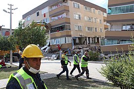 Emergency workers walk past a partially collapsed apartment.
 -
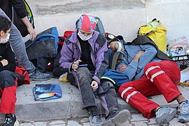 Emergency workers resting on a street.
 -
![Emrah Apartment; 32 people died.[117]](//upload.wikimedia.org/wikipedia/commons/thumb/c/c7/House_built_on_the_site_of_a_demolished_building._Excessive_ground_stiffness_in_center_led_to_such_cracks.jpg/385px-House_built_on_the_site_of_a_demolished_building._Excessive_ground_stiffness_in_center_led_to_such_cracks.jpg) Emrah Apartment; 32 people died.[117]
Emrah Apartment; 32 people died.[117]

![Removal of debris from the Yılmaz Erbek Apartman in November. Eleven people died.[116]](/wiki/File:Debris_removal_work.jpg)


![Emrah Apartment; 32 people died.[117]](/wiki/File:House_built_on_the_site_of_a_demolished_building._Excessive_ground_stiffness_in_center_led_to_such_cracks.jpg)
See also[edit]
- 2020s in environmental history
- List of earthquakes in 2020
- List of earthquakes in Greece
- List of earthquakes in Turkey
Notes[edit]
References[edit]
- ^ "Доганлар". 31 October 2020. Archived from the original on 23 October 2022. Retrieved 23 October 2022.
- ^ "Twenty one dead, more than 700 wounded in earthquake in Turkey's Izmir". Ahval. 30 October 2020. Archived from the original on 31 October 2020. Retrieved 30 October 2020.
- ^ a b Onat, Onur; Yön, Burak; Öncü, Mehmet Emin; Varolgüneş, Sadık; Karaşin, Abdulhalim; Cemalgil, Selim (2022). "Field reconnaissance and structural assessment of the October 30, 2020, Samos, Aegean Sea earthquake: an example of severe damage due to the basin effect". Natural Hazards. 112 (1): 75–117. Bibcode:2022NatHa.112...75O. doi:10.1007/s11069-021-05173-y. PMC 8782695. PMID 35095193.
- ^ a b c d International Seismological Centre. Event Bibliography. Thatcham, United Kingdom. [Event 619514791].
- ^ "Three-year-old girl rescued 91 hours after Turkey quake". Al Jazeera.
- ^ a b "Earthquake hits Greece and Turkey, bringing deaths and floods". BBC News. 30 October 2020. Retrieved 30 October 2020.
- ^ "Celal Şengör isyan etti: Lütfen şu 6,6'yı artık silin". cumhuriyet.com.tr (in Turkish). Cumhuriyet. 2 November 2020. Retrieved 2 November 2020.
- ^ "Son dakika... İzmir'de 6.9 büyüklüğünde deprem! İstanbul'da da hissedildi!" [Last minute... 6.9 magnitude earthquake in Izmir! It was felt in Istanbul too!]. sozcu.com.tr (in Turkish). Sözcü. 31 October 2020. Retrieved 2 November 2020.
- ^ a b Özmen, Merve Yıldızalp (14 November 2020). "İzmir'deki depremde can kaybı 116'ya yükseldi". Anadolu Agency.
- ^ admin (8 November 2020). "Turkey's earthquake death toll rises to 115". Time24 Story. Archived from the original on 9 November 2020. Retrieved 9 November 2020.
- ^ RTnews (31 October 2020). "Turkey's Erdogan & Greek PM Mitsotakis exchange words of SUPPORT after deadly Aegean Sea quake hits both nations". EMEA Tribune. Retrieved 5 November 2020.[permanent dead link]
- ^ Kejie Chen; Zhenguo Zhang; Cunren Liang; Changhu Xue; Peng Liu (2020). "Kinematics and Dynamics of the 24 January 2020 Mw 6.7 Elazig, Turkey Earthquake". Earth and Space Science. 7 (11). American Geophysical Union. Bibcode:2020E&SS....701452C. doi:10.1029/2020EA001452. S2CID 228829076.
- ^ Kiratzi, Anastasia A. (2014). "Mechanisms of Earthquakes in Aegean". Encyclopedia of Earthquake Engineering. Department of Geophysics. Aristotle University of Thessaloniki, Greece. pp. 1–22. doi:10.1007/978-3-642-36197-5_299-1. ISBN 978-3-642-36197-5.
{{cite book}}: CS1 maint: location missing publisher (link) - ^ a b c d e Kemal Onder Cetin; George Mylonakis; Anastasios Sextos; Jonathan Paul Stewart (31 December 2020). "Seismological and Engineering Effects of the M 7.0 Samos Island (Aegean Sea) Earthquake" (PDF). Geotechnical Extreme Events Reconnaissance Association. GEER-069. doi:10.18118/G6H088. Retrieved 23 September 2021.
- ^ Wang, Rosalynn (30 November 2020). "Earthquake Risk in the Eastern Mediterranean". air-worldwide.com. Retrieved 4 April 2021.
- ^ National Geophysical Data Center / World Data Service (NGDC/WDS): NCEI/WDS Global Significant Earthquake Database. NOAA National Centers for Environmental Information. "Significant Earthquake Information". doi:10.7289/V5TD9V7K. Retrieved 21 March 2024.
- ^ a b Aybige Akinci; Daniele Cheloni; Ahmet Anil Dindar (12 February 2021). "The 30 October 2020 Samos (Eastern Aegean Sea) Earthquake: effects of source rupture, path and local-site conditions on the observed and simulated ground motions" (PDF). Research Square. doi:10.21203/rs.3.rs-215817/v1. S2CID 233903885. Archived from the original (PDF) on 17 February 2021. Retrieved 4 April 2021.
- ^ a b Eyidoğan, Haluk (2020). "Report on the seismological characteristics and effects of the 30 October 2020 Samos-Kuşadası Bay earthquake (Mw7.0) in the western Aegean Sea".
- ^ Foumelis, M., Papazachos, C., Papadimitriou (28 March 2021). "On rapid multidisciplinary response aspects for Samos 2020 M7.0 earthquake". Acta Geophysica. 69 (3): 1025–1048. Bibcode:2021AcGeo..69.1025F. doi:10.1007/s11600-021-00578-6.
{{cite journal}}: CS1 maint: multiple names: authors list (link) - ^ "M 7.0 – 15 km NNE of Néon Karlovásion, Greece". USGS. Archived from the original on 30 October 2020. Retrieved 30 October 2020.
 This article incorporates text from this source, which is in the public domain.
- ^ Spyros PAVLIDES, Theodoros TSAPANOS, Nikos ZOUROS, Sotiris SBORAS, George KORAVOS and Alexandros CHATZIPETROS (2009). "Using active fault data for assessing seismic hazard: a case study from NE Aegean sea, Greece". Proceedings of the XVII International Conference on Soil Mechanics & Geotechnical Engineering, Earthquake Geotechnical Engineering Satellite Conference.
{{cite journal}}: CS1 maint: multiple names: authors list (link) - ^ a b P. Papadimitriou, V. Kapetanidis, A. Karakonstantis, I. Spingos, I. Kassaras, V. Sakkas, V. Kouskouna, A. Karatzetzou, K. Pavlou, G. Kaviris, N. Voulgaris (2020). "Preliminary report on the Mw=6.9 Samos earthquake of 30 October 2020". Retrieved 26 December 2020.
{{cite web}}: CS1 maint: multiple names: authors list (link) - ^ Ganas, Athanassios; Elias, Panagiotis; Briole, Pierre; Tsironi, Varvara; Valkaniotis, Sotiris; Escartin, Javier; Karasante, Ilektra; Efstathiou, Eirini (5 November 2020). "Fault responsible for Samos earthquake identified". Temblor.
- ^ a b Jiannan Meng; Ozan Sinoplu; Zhipeng Zhou; Bulent Tokay; Timothy Kusky; Erdin Bozkurt; Lu Wang (2021). "Greece and Turkey Shaken by African tectonic retreat". Scientific Reports. 11 (6486): 6486. Bibcode:2021NatSR..11.6486M. doi:10.1038/s41598-021-86063-y. PMC 7985315. PMID 33753832. S2CID 232322725.
- ^ Konstantinos Chousianitis; A. Ozgun Konca (2021). "Rupture Process of the 2020 Mw7.0 Samos Earthquake and its Effect on Surrounding Active Faults". Geophysical Research Letters. 48 (14). Bibcode:2021GeoRL..4894162C. doi:10.1029/2021GL094162. S2CID 237715488.
- ^ Vladimir Plicka; Frantisek Gallovic; Jiří Zahradník; Anna Serpetsidaki; Efthimios Sokos; Nikos Vavlas; Anastasia A. Kiratzi (2021). "The 2020 Samos (Aegean Sea) M7 earthquake: a normal fault with rupture directivity and near surface slip explaining the tsunami generation and coastal uplift". Tectonics. 105. ESSOAr. Bibcode:2021esoar.10506903P. doi:10.1002/essoar.10506903.1. S2CID 239735948.
- ^ Ayhan Nuhoğlu; Mehmet Fahrettin Erener; Çağlayan Hızal; Cem Kıncal; Devrim Şüfa Erdoğan; Özkan Cevde Özdağ; Mustafa Akgün; Emre Ercan; Emre Kalfa; Duygu Köksal; Yaprak İpek; Alper Sezer (2021). "A reconnaissance study in Izmir (Bornova Plain) affected by October 30, 2020 Samos earthquake". International Journal of Disaster Risk Reduction. 63 (102465): 102465. Bibcode:2021IJDRR..6302465N. doi:10.1016/j.ijdrr.2021.102465. hdl:11147/11835. Retrieved 24 September 2021.
- ^ Mauricio Morales; Oguz C. Celik. "EERI PERW 2021 – Part 1: Aegean Sea Earthquake". slc.eeri.org. Earthquake Engineering Research Institute. Archived from the original on 27 June 2022. Retrieved 12 October 2021.
- ^ "ITSAK ShakeMap: Northern coast of W. Turkey". Institute of Engineering Seismology and Earthquake Engineering. 30 October 2020. Retrieved 8 June 2021.
- ^ "Earthquake Seismic Stations". shakemaps.itsak.gr. Institute of Engineering Seismology and Earthquake Engineering. 30 October 2020. Retrieved 8 June 2021.
- ^ "Earthquake hits Greece and Turkey, bringing deaths and floods". BBC News. 30 October 2020.
- ^ a b c Dogan, G.G., Yalciner, A.C., Yuksel, Y. (2021). "The 30 October 2020 Aegean Sea Tsunami: Post-Event Field Survey Along Turkish Coast". Pure and Applied Geophysics. 178 (3): 785–812. Bibcode:2021PApGe.178..785D. doi:10.1007/s00024-021-02693-3. ISSN 0033-4553. PMC 7982910. PMID 33776149.
{{cite journal}}: CS1 maint: multiple names: authors list (link) - ^ "İzmir Seferihisar Depremi-Duyuru 73 (08.11.2020 – 20.00)". AFAD.
- ^ "M 3.0 – 10 km WSW of Kuşadası, Turkey".
- ^ "M 4.4 – 5 km NW of Marathókampos, Greece". USGS-ANSS. Retrieved 26 December 2020.
- ^ "M 4.0 – 4 km N of Samos, Greece". USGS-ANSS. Retrieved 26 December 2020.
- ^ "M 4.9 – 8 km N of Kokkári, Greece". USGS-ANSS. Retrieved 26 December 2020.
- ^ "M 5.3 – 8 km NW of Kokkári, Greece". USGS-ANSS. Retrieved 26 December 2020.
- ^ "M 4.8 – 2 km SW of Samos, Greece". USGS-ANSS. Retrieved 26 December 2020.
- ^ "M 4.2 – 7 km NE of Samos, Greece". USGS-ANSS. Retrieved 26 December 2020.
- ^ "M 4.2 – 17 km NE of Agios Kirykos, Greece". USGS-ANSS. Retrieved 26 December 2020.
- ^ "M 4.1 – 9 km NNE of Néon Karlovásion, Greece". USGS-ANSS. Retrieved 26 December 2020.
- ^ "M 4.2 – 19 km WNW of Néon Karlovásion, Greece". USGS-ANSS. Retrieved 26 December 2020.
- ^ "M 4.9 – 10 km NNW of Kokkári, Greece". USGS-ANSS. Retrieved 26 December 2020.
- ^ "M 4.2 – 5 km W of Kokkári, Greece". USGS-ANSS. Retrieved 26 December 2020.
- ^ "M 4.3 – 26 km WNW of Néon Karlovásion, Greece". USGS-ANSS. Retrieved 26 December 2020.
- ^ "M 4.0 – 4 km NNE of Kokkári, Greece". USGS-ANSS. Retrieved 26 December 2020.
- ^ "M 4.2 – 9 km NNE of Samos, Greece". USGS-ANSS. Retrieved 26 December 2020.
- ^ "M 4.2 – 1 km NNE of Kokkári, Greece". USGS-ANSS. Retrieved 26 December 2020.
- ^ "M 4.4 – 2 km NNW of Kokkári, Greece". USGS-ANSS. Retrieved 26 December 2020.
- ^ "M 4.3 – 5 km NNE of Kokkári, Greece". USGS-ANSS. Retrieved 26 December 2020.
- ^ "M 4.4 – 20 km SSW of Seferihisar, Turkey". USGS-ANSS. Retrieved 26 December 2020.
- ^ "M 4.5 – 19 km WNW of Néon Karlovásion, Greece". USGS-ANSS. Retrieved 26 December 2020.
- ^ "M 4.0 – 22 km WNW of Néon Karlovásion, Greece". USGS-ANSS. Retrieved 26 December 2020.
- ^ "M 4.2 – 6 km ENE of Megálo Chorió, Greece". USGS-ANSS. Retrieved 26 December 2020.
- ^ "M 4.3 – 12 km NNE of Kokkári, Greece". USGS-ANSS. Retrieved 26 December 2020.
- ^ "M 4.6 – 9 km NE of Kokkári, Greece". USGS-ANSS. Retrieved 26 December 2020.
- ^ "M 4.4 – 9 km WSW of Kokkári, Greece". USGS-ANSS. Retrieved 26 December 2020.
- ^ "M 4.5 – 7 km ENE of Néon Karlovásion, Greece". USGS-ANSS. Retrieved 26 December 2020.
- ^ "M 4.1 – 7 km ENE of Agios Kirykos, Greece". USGS-ANSS. Retrieved 31 December 2020.
- ^ "M 4.8 - 10 km NNE of Néon Karlovásion, Greece". USGS-ANSS. Retrieved 21 December 2020.
- ^ a b c Specia, Megan; Stevis-Gridneff, Matina (30 October 2020). "Earthquake Rattles Western Turkey and Greece, Leveling Buildings". The New York Times. ISSN 0362-4331. Retrieved 30 October 2020.
- ^ a b c Dağ, Burak (4 November 2020). "Turkey sees larger tsunami after latest quake". Anadolu Agency. Archived from the original on 9 November 2020. Retrieved 9 November 2020.
- ^ a b Mohammad Heidarzadeh; Ignatius Ryan Pranantyo; Ryo Okuwaki; Gozde Guney Dogan; Ahmet C. Yalciner (2021). "Long Tsunami Oscillations Following the 30 October 2020 Mw 7.0 Aegean Sea Earthquake: Observations and Modelling". Pure and Applied Geophysics. 178 (5): 1531–1548. Bibcode:2021PApGe.178.1531H. doi:10.1007/s00024-021-02761-8. S2CID 235173559.
- ^ "Seferihisar'da tsunami: Sokakları deniz suyu bastı" [Tsunami in Seferihisar: Sea water flooded the streets]. NTV. 30 October 2020. Retrieved 30 October 2020.
- ^ "Son dakika! İzmir'de tsunami paniği" [Last minute! Tsunami panic in Izmir]. Milliyet. 30 October 2020. Retrieved 30 October 2020.
- ^ M. Ersen Aksoy (24 May 2021). "Post-event field observations in the İzmir–Sığacık village for the tsunami of the 30 October 2020 Samos (Greece) Mw 6.9 earthquake". Acta Geophysica. 69 (3): 1113–1125. Bibcode:2021AcGeo..69.1113A. doi:10.1007/s11600-021-00582-w. S2CID 235128278.
- ^ "Water floods streets of Greek island of Samos after earthquake". euronews. 31 October 2020. Retrieved 5 May 2021.
- ^ a b Ιoanna Triantafyllou, Marilia Gogou, Spyridon Mavroulis, Katerina-Navsika Katsetsiadou, Efthymios Lekkas and Gerassimos A. Papadopoulos. "The tsunami caused by the 30 October 2020 Samos (Greece), East Aegean Sea, Mw6.9 earthquake: impact assessment from post-event field survey and video records (v2, 16 Nov. 2020)". Journal of Marine Science and Engineering. 9 (1). doi:10.3390/jmse9010068.
{{cite journal}}: CS1 maint: multiple names: authors list (link) - ^ a b c d Spyridon Mavroulis; Ioanna Triantafyllou; Andreas Karavias; Marilia Gogou; Katerina-Navsika Katsetsiadou; Efthymios Lekkas; Gerassimos A. Papadopoulos; Issaak Parcharidis (6 April 2021). "Primary and Secondary Environmental Effects Triggered by the 30 October 2020, Mw = 7.0, Samos (Eastern Aegean Sea, Greece) Earthquake Based on Post-Event Field Surveys and InSAR Analysis". Applied Sciences. 11 (7): 3281. doi:10.3390/app11073281.
- ^ "Aegean Sea Earthquake October 2020". NASA Applied Science. NASA. 30 October 2020. Retrieved 29 October 2021.
- ^ "İzmir depreminin yol açtığı yıkım uzaydan görüntülendi". Archived from the original on 2 November 2022. Retrieved 2 November 2022.
- ^ Stathis Stiros (2021). "Impacts of the 2020 Samos earthquake on the modeling of ancient seismic events". Turkish Journal of Earth Sciences. 30 (SI-1): 738–747. doi:10.3906/yer-2107-7. S2CID 244963829.
- ^ "İzmir Büyükşehir Belediye Başkanı Tunç Soyer depremde kaç kişinin evsiz kaldığını açıkladı". Yeni Çağ Gazetesi (in Turkish). 4 November 2020. Retrieved 29 November 2020.
- ^ "Global Catastrophe Recap November 2020 Archived 9 October 2022 at Ghost Archive" (PDF). Aon. 10 December 2020. Retrieved 18 December 2020.
- ^ Liakos, Chris; Labropoulou, Elinda (30 October 2020). "Minor injuries and building damage reported on Greek island". CNN. Retrieved 30 October 2020.
- ^ Newsroom (31 October 2020). "Samos Earthquake: Over 200 autopsies – Damage to about 100 buildings in Karlovasi". CNN Greece. Retrieved 26 December 2020.
- ^ Labropoulou, Elinda (30 October 2020). "Buildings damaged on Greek island of Samos". CNN. Retrieved 30 October 2020.
- ^ Ahmet Can Altunişik; Barbaros Atmaca; Murat Emre Kartal; Murat Günaydin; Serhat Demir; Alper Uluşan (2021). "Assessment of Structural Damage Following the October 30, 2020 Aegean Sea Earthquake and Tsunami". Journal of Earthquake and Tsunami. 15 (6): 1–43. doi:10.1142/S1793431121500299. S2CID 235554231.
- ^ "Rıza Bey Apartmanı davasında ara karar açıklandı" [A park will be built in place of Rıza Bey Apartment.]. Cumhuriyet. 10 September 2021. Retrieved 6 November 2021.
- ^ "Destroyed buildings in İzmir not earthquake resistant, reports show". Hürriyet Daily News. 1 November 2020. Retrieved 20 November 2020.
- ^ a b Hasan Emre Demirci; Mustafa Karaman; Subhamoy Bhattacharya (2 November 2021). "A survey of damage observed in Izmir due to 2020 Samos-Izmir earthquake". Natural Hazards. 111: 1047–1064. doi:10.1007/s11069-021-05085-x. hdl:11147/11875. S2CID 240358305.
- ^ Erdik, Demircioğlu, Tüzün, Mustafa, Mine B., Cüneyt (14 November 2020). "Forensic analysis reveals the causes of building damage in İzmir in the Oct. 30 Aegean Sea earthquake". Retrieved 20 November 2020.
{{cite web}}: CS1 maint: multiple names: authors list (link) - ^ Akyavas, Aziz; Smith, Saphora; Mulligan, Matthew (30 October 2020). "Strong quake hits coastal Turkey and Greece, killing at least 6 and injuring over 200". Reuters. Retrieved 30 October 2020 – via Yahoo News.
- ^ "TSK'ye ait uçak AFAD ve jandarma ekiplerini bölgeye ulaştırmak için hareket etti" [The plane belonging to the TAF moved to bring AFAD and gendarmerie teams to the region]. CNN Türk (in Turkish). 30 October 2020. Retrieved 30 October 2020.
- ^ "Turkish Red Crescent mobilizes food assistance teams". CNN (in Turkish). 30 October 2020. Retrieved 30 October 2020.
- ^ "Powerful Quake in Aegean Sea Leaves 6 Dead; Buildings Toppled in Turkey, Greece". Voice of America. 30 October 2020. Retrieved 30 October 2020.
- ^ "Three-year-old girl rescued 91 hours after Turkey quake".
- ^ Sevinclidir, Pinar (3 November 2020). "2nd little girl pulled alive from Turkey's earthquake devastation". CBS News. Retrieved 17 August 2022.
- ^ Sevinclidir, Pinar (2 November 2020). "Little girl rescued from rubble after 65 hours in Turkey as earthquake death toll hits 91". CBS News. Retrieved 17 August 2022.
- ^ "Turkey quake toll rises to 116 as rescuers conclude searches". Al Jazeera. 4 November 2020.
- ^ "Turkey indicts 29 over Izmir earthquake damage". Daily Sabah. 8 June 2021. Retrieved 4 November 2021.
- ^ "Pressure grows on Turkish government over use of earthquake taxes". Arab News. 5 November 2020. Retrieved 11 February 2023.
- ^ "Yılmaz Erbek Apartmanı'nda market için 7 işyeri birleştirilirken kolonlar kesilmiş" [Columns were cut while 7 workplaces were combined for the market in Yılmaz Erbek Apartment.] (in Turkish). Independent Türkçe. 5 November 2020. Retrieved 4 November 2021.
- ^ "İzmir depreminde yıkılan Yılmaz Erbek Apartmanı göz göre göre yıkılmış" [Yılmaz Erbek Apartment, which was destroyed in the Izmir earthquake, was demolished in plain sight.] (in Turkish). Evrensel. 13 June 2021. Retrieved 4 November 2021.
- ^ "İzmir depreminde 15 kişinin öldüğü Doğanlar Apartmanı'yla ilgili çürük iddiası" [Rotten claim about Doğanlar Apartment where 15 people died in İzmir earthquake]. NTV. 9 September 2021. Retrieved 4 November 2021.
- ^ "Rıza Bey Apartmanı davasında ara karar açıklandı" [Interim decision announced in Rıza Bey Apartment case] (in Turkish). Cumhuriyet. 10 September 2021. Retrieved 6 November 2021.
- ^ "Turkey, Greece pledge mutual aid, support after strong quake shakes Aegean". Daily Sabah. 30 October 2020. Retrieved 13 January 2021.
- ^ "Aegean Sea Earthquake October 2020 | NASA Applied Sciences". appliedsciences.nasa.gov. 30 October 2020. Retrieved 13 January 2021.
- ^ a b c d e f g h Hamit, Dilara (30 October 2020). "Condolences pour in after quake shakes Turkey". Anadolu Agency. Retrieved 25 December 2020.
- ^ "JK Siap Kirim Relawan PMI Bantu Evakuasi Korban Gempa di Turki - Nasional Tempo.co". nasional.tempo.co. Retrieved 20 January 2023.
- ^ "France ready to help Turkey, Greece after earthquake". Deccan Herald. 30 October 2020. Retrieved 25 December 2020.
- ^ Qarjouli, Asmahan (3 November 2020). "Qatar mobilizes disaster management center in Izmir earthquake response". Doha News. Retrieved 28 December 2020.
- ^ Satubaldina, Assel (3 November 2020). "President Tokayev Sends Condolences to Turkey Over Izmir Earthquake". The Astana Times. Retrieved 25 December 2020.
- ^ Emre Aytekin, Mehmet Yilmaz and Omer Erdem (2 November 2020). "Countries grieve with Turkey after deadly quake". Anadolu Agency. Retrieved 28 December 2020.
- ^ Latif, Aamir (31 October 2020). "Pakistan stands with quake-hit Turkey". Anadolu Agency. Retrieved 25 December 2020.
- ^ "Russia's Putin conveys condolences to Erdoğan over earthquake in Turkey's Izmir". Daily Sabah. 30 October 2020. Retrieved 4 December 2020.
- ^ Interfax-Ukraine (1 November 2020). "Zelensky condolences to Turkey, Greece over earthquake". Kyiv Post. Retrieved 25 December 2020.
- ^ "Athens offers to assist rescue efforts in Izmir". Kathimerini. 30 October 2020. Retrieved 4 December 2020.
- ^ Mainichi Japan (2 November 2020). "Japan offers condolences to Turkey over deadly quake". The Mainichi. Archived from the original on 2 November 2020. Retrieved 4 December 2020.
- ^ "Singapore extends condolences to Turkey and Greece after Aegean Sea earthquake". Channel News Asia. 1 November 2020. Retrieved 25 December 2020.
- ^ a b "Turkey, Greece pledge mutual aid, support after strong quake shakes Aegean". Daily Sabah. 30 October 2020. Retrieved 4 December 2020.
- ^ Turan, Rabia Iclal (30 October 2020). "EU, NATO condole with quake-hit Turkey, Greece". Anadolu Agency. Retrieved 25 December 2020.
- ^ "İzmir Depreminin yıl dönümünde Çiğli'de deprem anıtı açıldı" [An earthquake monument was opened in Çiğli on the anniversary of the Izmir Earthquake] (in Turkish). Evrensel. 30 October 2021. Retrieved 4 November 2021.
- ^ "İzmir depreminde hayatını kaybeden 117 kişi anıldı". En Son Haber (in Turkish). 30 October 2021. Retrieved 6 November 2021.
- ^ "Дом Йылмаз Ебрек". 2 November 2020. Archived from the original on 23 October 2022. Retrieved 23 October 2022.
- ^ "30 Ekim'de yıkılan Emrah apartmanının son görüntüsü." YouTube.
Further reading[edit]
- Ganas, Athanassios; Elias, Panagiotis; Briole, Pierre; Valkaniotis, Sotiris; Escartin, Javier; Tsironi, Varvara; Karasante, Ilektra; Kosma, Chrysanthi (2021). "Co-seismic and post-seismic deformation, field observations and fault model of the 30 October 2020 Mw = 7.0 Samos earthquake, Aegean Sea" (PDF). Acta Geophysica. 69 (3): 999–1024. Bibcode:2021AcGeo..69..999G. doi:10.1007/s11600-021-00599-1. ISSN 1895-6572. S2CID 234351525.
External links[edit]
- 2020 earthquakes
- 2020 disasters in Greece
- 2020 disasters in Turkey
- 2020 tsunamis
- 2020s in İzmir
- Earthquakes in Greece
- Earthquakes in Turkey
- History of the Aegean Sea
- History of İzmir Province
- History of Samos
- October 2020 events in Europe
- October 2020 events in Greece
- October 2020 events in Turkey
- Tsunamis in Greece
- Tsunamis in Turkey