Allegheny Portage Railroad
Last updatedAllegheny Portage Railroad | |
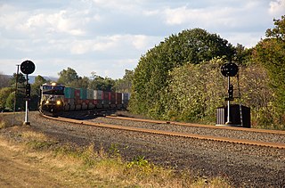
 Incline 6 Trail and Recreated Tracks | |
  | |
| Location | Blair and Cambria counties, Pennsylvania, United States |
|---|---|
| Nearest city | Altoona, Pennsylvania, U.S. |
| Coordinates | 40°27′15″N78°32′25″W / 40.45417°N 78.54028°W |
| Area | 1,296 acres (524 ha) |
| Built | 1831-1834 |
| Architectural style | Wood, Stone, Wrought Iron |
| Visitation | 118,931 [1] (2009) |
| Website | Allegheny Portage Railroad National Historic Site |
| MPS | Allegheny Portage Railroad MPS |
| NRHP reference No. | 66000648 [2] |
| Significant dates | |
| Added to NRHP | October 15, 1966 |
| Designated NHL | December 29, 1962 [3] |
| Designated PHMC | April 01, 1947 [4] |
The Allegheny Portage Railroad was the first railroad constructed through the Allegheny Mountains in central Pennsylvania. It operated from 1834 to 1854 as the first transportation infrastructure through the gaps of the Allegheny that connected the midwest to the eastern seaboard across the barrier range of the Allegheny Front. Approximately 36 miles (58 km) long overall, both ends connected to the Pennsylvania Canal, and the system was primarily used as a portage railway, hauling river boats and barges over the divide between the Ohio and the Susquehanna Rivers. Today, the remains of the railroad are preserved within the Allegheny Portage Railroad National Historic Site operated by the National Park Service.
Contents
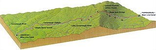
The railroad was authorized as part of the Main Line of Public Works legislation in 1824. It had five inclines on either side of the drainage divide running athwart the ridge line from Blair Gap through along the kinked saddle at the summit into Cresson, Pennsylvania. The endpoints connected to the Canal at Johnstown on the west through the relative flats to Hollidaysburg on the east. The Railroad utilized cleverly designed wheeled barges to ride a narrow-gauge rail track with steam-powered stationary engines lifting the vehicles. The roadbed of the railroad did not incline monotonically upwards, but rose in relatively long, saw-toothed stretches of slightly-sloped flat terrain suitable to animal powered towing, alternating with steep cable railway inclined planes using static steam engine powered windlasses, similar to mechanisms of modern ski lifts.
Except for peak moments of severe storms, it was an all-weather, all-seasons operation. Along with the rest of the Main Works, it cut transport time from Philadelphia to the Ohio River from weeks to just 3–5 days. Considered a technological marvel in its day, it played a critical role in opening the interior of the United States beyond the Appalachian Mountains to settlement and commerce. It included the first railroad tunnel in the United States, the Staple Bend Tunnel, and its inauguration was marked with great fanfare.
History

Construction of the Old Portage Railroad from Hollidaysburg to Johnstown, thirty six miles long, began in 1831 and took three years to complete. It included a tunnel 900 feet (274 m) long as well as a viaduct over the Little Conemaugh River upstream from Johnstown. The vertical ascent from Johnstown was 1,172 feet (357 m). The vertical ascent from Hollidaysburg was 1,399 feet (426 m). The project was financed by the Commonwealth of Pennsylvania as a means to compete with the Erie Canal in New York and the Chesapeake and Ohio Canal and Baltimore and Ohio Railroad in Maryland. The work was done largely through private contractors. The railroad utilized eleven grade lines and ten cable inclined planes, five on either side of the summit of the Allegheny Ridge, to carry loaded canal boats on flatbed railroad cars. Trains of two-three cars were pulled on grade lines by mules. On inclined planes, stationary steam engines pulled up and lowered down cars by hemp ropes switching to wire ropes in 1842. [5]
The entire Main Line system connecting Philadelphia and Pittsburgh via the Philadelphia-Columbia railroad, the Columbia-Hollidaysburg canal, the Portage railroad linking Hollidaysburg to Johnstown, and a canal from Johnstown to Pittsburgh, was 400 miles (644 km) long. A typical ride took 4 days instead of the former 23-day horse-wagon journey. [6] The Old Portage Railroad was in operation for twenty years being considered "the wonder of America." [7] Charles Dickens wrote a contemporary account of travel on the railroad in Chapter 10 of his American Notes. [8] Quoted at length in the Pennsylvania guide, Dickens "described travel on the Portage in 1842," describing aspects of the Portage Railroad's immediate social and geographic context, as well as mechanical strategies used by the Railroad for coping with the steep grades encountered on the route : [9]
. . . Occasionally the rails were laid upon the extreme verge of a giddy precipice; and looking from the carriage window, the traveler gazes sheer down, without a stone or scrap of fence between, into the mountain depths below . . . It was very pretty travelling thus at a rapid pace along the heights of the mountains in a keen wind, to look down into a valley full of light and softness; catching glimpses, through the treetops, of scattered cabins; . . . men in their shirt sleeves, looking on at their unfinished houses, planning out tomorrow's work; and we riding onward, high above them, like a whirlwind. It was amusing, too, when we had dined, and rattled down a steep pass, having no other moving power than the weight of the carriages themselves, to see the engine, released long after us, come buzzing down alone, like a great insect, its back of green and gold so shining in the sun . . . It stopped short of us . . . when we reached the canal, and, before we left the wharf, went panting up this hill again, with the passengers who had waited our arrival for the means of traversing the road by which we had come.
— Federal Writers'Project, "Part III: Tours", Pennsylvania: A Guide to the Keystone State (1940)
In the 1850s, the Main Line of Public Works and its portage railroad was rendered obsolete by the advance of railway technology and railroad engineering. Early in 1846 the Legislature chartered the Pennsylvania Railroad (PRR) to cross the entire state in response to plans by the Baltimore and Ohio Railroad to reach the Ohio Valley through Virginia. In December 1852 trains started to run between Philadelphia and Pittsburgh shortening the travel time from 4 days to 13 hours. [10]
Construction on the New Portage Railroad, a 40-mile realignment to cross the Allegheny Ridge bypassing inclines, started in 1851 and cost $2.14 million. The PRR raised sufficient investment and had enough quick success that they bought the existing Portage railroad and other parts of the Main Line of Public Works from the state on July 31, 1857. The PRR abandoned most of the line and used the rest as local branches; "anything of value was either sold or stripped from the Allegheny Portage Railroad." [11]
Nearly half a century later, the graded roadbeds of the descending section east of the Gallitzin Tunnel were re-railed with standard gauge freight tracks. The line reopened as a freight bypass line in 1904.
Pennsylvania Railroad successor Conrail abandoned this line to Hollidaysburg and most of the branch trackage along the Juniata River in 1981 and removed the rails.
The Allegheny Portage Railroad was designated as a National Historic Civil Engineering Landmark by the American Society of Civil Engineers in 1987. [12] [13]

National Historic Site
The National Historic Site was established on 1,296 acres (524 ha) in 1964 and is about 12 miles (19.3 km) west of Altoona, [14] in Blair and Cambria counties. [15]
The park service operates a visitor center with interpretive exhibits near the old line. [14] [16] Nearby is the Samuel Lemon House, a tavern located alongside the railroad near Cresson that was a popular stop for railroad passengers; it has been converted into a historical museum by the National Park Service. The NPS also maintains a length of reconstructed track, an engine house with exhibits, a picnic area, and hiking trails. [16]
A skew arch bridge, a masterwork of cut stone construction, is another feature of the site near the Lemon House. The bridge is 60.4 feet (18.4 m) long on the south elevation, 54.9 feet (16.7 m) long on the north elevation, and 22.2 feet (6.8 m) high. [17] It was the only bridge on the line that was built to carry a road. [17]
The Staple Bend Tunnel is preserved in a separate unit of the historic site, 5 miles (8.0 km) east of Johnstown. [18]
Gallery
 Exterior of Engine House 6 Exhibit Building
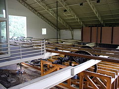 Interior of Engine House 6 Exhibit Building
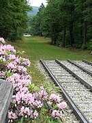 Incline looking from the Engine house
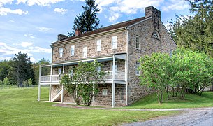 Exterior of the Lemon House
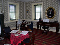 Inside the Lemon House
 Inside the Lemon House
 North face of the Skew Arch Bridge at the National Historic Site
 South face of the Skew Arch Bridge
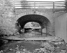 Lilly Culvert, built 1832, along the APRR


See also
Related Research Articles
The Little Conemaugh River is a tributary of the Conemaugh River, approximately 30 mi (48 km) long, in western Pennsylvania in the United States.

The Horseshoe Curve is a three-track railroad curve on Norfolk Southern Railway's Pittsburgh Line in Blair County, Pennsylvania. The curve is roughly 2,375 feet (700 m) long and 1,300 feet (400 m) in diameter. Completed in 1854 by the Pennsylvania Railroad as a way to reduce the westbound grade to the summit of the Allegheny Mountains, it replaced the time-consuming Allegheny Portage Railroad, which was the only other route across the mountains for large vehicles. The curve was later owned and used by three Pennsylvania Railroad successors: Penn Central, Conrail, and Norfolk Southern.

Union Station, also known as Pennsylvania Station and commonly called Penn Station, is a historic train station in Downtown Pittsburgh, Pennsylvania. It was one of several passenger rail stations that served Pittsburgh during the 20th century; others included the Pittsburgh & Lake Erie Railroad Station, the Baltimore and Ohio Station, and Wabash Pittsburgh Terminal, and it is the only surviving station in active use.

The Laurel Highlands is a region in southwestern Pennsylvania made up of Fayette County, Somerset County, and Westmoreland County. It has a population of about 600,000 people.

This is a list of the earliest railroads in North America, including various railroad-like precursors to the general modern form of a company or government agency operating locomotive-drawn trains on metal tracks.

The Main Line of Public Works was a package of legislation passed by the Commonwealth of Pennsylvania in 1826 to establish a means of transporting freight between Philadelphia and Pittsburgh. It funded the construction of various long-proposed canal and road projects, mostly in southern Pennsylvania, that became a canal system and later added railroads. Built between 1826 and 1834, it established the Pennsylvania Canal System and the Allegheny Portage Railroad.
Philadelphia and Columbia Railroad (P&CR) (1834) was one of the earliest commercial railroads in the United States, running 82 miles (132 km) from Philadelphia to Columbia, Pennsylvania, it was built by the Pennsylvania Canal Commission in lieu of a canal from Columbia to Philadelphia; in 1857 it became part of the Pennsylvania Railroad. It is currently owned and operated by Amtrak as its electrified Keystone Corridor. The Philadelphia and Columbia Railroad's western terminus was located near the former ferry site known as Wright's Ferry, in the town once of that name, but now Columbia in Lancaster County. There the P&CR met with the Pennsylvania Canal—navigations and improvements on the Susquehanna River east bank approximately 30 miles (48.3 km) south of Harrisburg, Pennsylvania. Most of its right-of-way was obtained by the actions of the Pennsylvania Canal Commission which operated the railroad under the various enabling acts of the Pennsylvania legislature known as the Main Line of Public Works in support of a far sighted plan to link the whole state by canals. With an engineering study reporting back a finding that obtaining sufficient waters to flood the intended 80+ mile canal from Philadelphia to Columbia, the Canal Commission and legislature authorized the railway on the right of way intended for the canal.

The Gallitzin Tunnels in Gallitzin, Pennsylvania, are a set of three adjacent tunnels through the Allegheny Mountains in western Pennsylvania. They were completed in 1854, 1855, and 1902 by the Pennsylvania Railroad as part of the cross-state route that includes the nearby Horseshoe Curve to the east. Their ownership has since passed to Penn Central Transportation Company, then to Conrail, and most recently to the Norfolk Southern Railway. The tunnels are currently used by Norfolk Southern freight trains and Amtrak Pennsylvanian passenger trains.

The Staple Bend Tunnel, about 4 miles (6.4 km) east of Johnstown, Pennsylvania, in a town called Mineral Point, was constructed between 1831 and 1834 for the Allegheny Portage Railroad. Construction began on April 12, 1831. This tunnel, at 901 feet (275 m) in length, was the first railway tunnel constructed in the United States. It is rock-bored and stone-lined.

This is a list of properties and districts listed on the National Register of Historic Places in Pennsylvania. As of 2015, there are over 3,000 listed sites in Pennsylvania. All 67 counties in Pennsylvania have listings on the National Register.

Transportation in Pittsburgh, Pennsylvania is different than in many other major American cities. A large metropolitan area that is surrounded by rivers and hills, Pittsburgh has an infrastructure system that has been built out over the years to include roads, tunnels, bridges, railroads, inclines, bike paths, and stairways; however, the hills and rivers still form many barriers to transportation within the city.

The Main Line of the Pennsylvania Railroad was a rail line in Pennsylvania connecting Philadelphia with Pittsburgh via Harrisburg. The rail line was split into two rail lines, and now all of its right-of-way is a cross-state corridor, composed of Amtrak's Philadelphia to Harrisburg Main Line and the Norfolk Southern Railway's Pittsburgh Line.
The Pennsylvania Canal, sometimes known as the Pennsylvania Canal system, was a complex system of transportation infrastructure improvements, including canals, dams, locks, tow paths, aqueducts, and viaducts. The canal was constructed and assembled over several decades beginning in 1824, the year of the first enabling act and budget items.

The Pennsylvania Railroad Old Bridge over Standing Stone Creek, also known as the Conrail Old Bridge over Standing Stone Creek, is an historic, American, multi-span, stone arch bridge that spans Standing Stone Creek and is located in Huntingdon, Huntingdon County, Pennsylvania.

Bridge in Portage Township is a historic stone arch bridge located at Portage Township in Cambria County, Pennsylvania. It was built by the Allegheny Portage Railroad in 1832, and is an 18-foot-long (5.5 m) bridge, with a semi-circular arch. It is built of coursed ashlar and crosses Bens Creek.

Lilly Bridge is a historic stone arch bridge located at Lilly in Cambria County, Pennsylvania. It was built by the Allegheny Portage Railroad in 1832, and is an 18-foot-long (5.5 m) bridge, with an elliptical shape and curved wingalls. It is built of roughly squared ashlar and crosses Burgoon Run.
The Pittsburgh Line is the Norfolk Southern Railway's primary east–west artery in its Pittsburgh Division and Harrisburg Division across the U.S. state of Pennsylvania and is part of the Keystone Corridor, Amtrak-Norfolk Southern's combined rail corridor.
Foot of Ten is a census-designated place in Allegheny and Juniata Townships in Blair County, Pennsylvania, United States. It is located approximately one mile west of the small borough Duncansville on Foot of Ten Road, and about 2.5 miles (4 km) north of the even smaller borough Newry. It is often considered a region of Duncansville, despite lying outside the borough limits. As of the 2010 census, the population was 672 residents.
The New Portage Branch was a rail line which ran between the New Portage Tunnel and Duncansville, Pennsylvania.
References
- ↑ "NPS Annual Recreation Visits Report". National Park Service.
- ↑ "National Register Information System". National Register of Historic Places . National Park Service. March 15, 2006.
- ↑ "Allegheny Portage Railroad of the Pennsylvania Canal". National Historic Landmark summary listing. National Park Service. Archived from the original on October 7, 2012. Retrieved July 1, 2008.
- ↑ "PHMC Historical Markers". Historical Marker Database. Pennsylvania Historical & Museum Commission. Archived from the original on December 7, 2013. Retrieved December 10, 2013.
- ↑ Modern History of Wire Rope by Donald Sayenga
- ↑ Ten inclined planes on the Allegheny Portage Railroad, National Park Service
- ↑ Boucher, John N. History of Westmoreland County, Pennsylvania. New York: The Lewis Publishing Company, 1906.
- ↑ Dickens, Charles (2007) [Written 1842]. American notes for general circulation. Barnes & Noble Books. ISBN 978-0-7607-6892-1.
- ↑ Federal Writers' Project (1940). Pennsylvania: A Guide to the Keystone State (1st ed.). New York: Oxford University Press. p. 391.
- ↑ Allegheny Portage Railroad, Gallitzin, PA: Life on the Portage
- ↑ Lindeman, Teresa F. Allegheny Portage Railroad National Historic Site: An engineering marvel, Pittsburgh Post-Gazette, April 19, 2016.
- ↑ "Allegheny Portage Railroad Historical Marker". The Historical Marker Database. Retrieved February 6, 2022.
- ↑ Hansen, Brett (January 2008). "Climbing the Mountain: The Allegheny Portage Railroad". Civil Engineering. Vol. 78, no. 1. American Society of Civil Engineers. pp. 36–37. doi:10.1061/ciegag.0000806 . Retrieved February 6, 2022.
- 1 2 "Basic Information". Allegheny Portage Railroad National Historic Site, Pennsylvania. National Park Service. December 10, 2016. Retrieved November 7, 2017.
- ↑ 107th Congress (September 4, 2002), H. R. 4682 [Report No. 107–634]: To revise the boundary of the Allegheny Portage Railroad National Historic Site, and for other purposes (the "Allegheny Portage Railroad National Historic Site Boundary Revision Act") (PDF), U.S. Government Publishing Office, retrieved October 21, 2009
- 1 2 "Things to Do". Allegheny Portage Railroad National Historic Site, Pennsylvania. National Park Service. October 31, 2017. Retrieved November 7, 2017.
- 1 2 Allegheny Portage Railroad: Skew Arch Bridge (PDF), National Park Service, August 2010, retrieved November 7, 2017
- ↑ "Staple Bend Tunnel". Allegheny Portage Railroad National Historic Site, Pennsylvania. National Park Service. December 10, 2016. Retrieved November 7, 2017.
Bibliography
- Baumgardner, Mahlon J.; Hoenstine, Floyd G. (1952). The Allegheny Old Portage Railroad 1834-1854: Building Operation and travel between Hollidaysburg and Johnstown Pennsylvania. Cresson, Pennsylvania: Self Published by the Blair County Chapter and Cambria County Chapter of the Sons of the American Revolution.
- McKee, Harley J. (1980). Introduction to Early American Masonry: Stone, Brick, Mortar, and Plaster. The Preservation Press. ISBN 978-0891330066.
External links
- Historic American Buildings Survey (HABS) No. PA-1232, " Skew Arch Bridge, Spanning Incline No. 6 ", 3 photos, 5 measured drawings, 1 photo caption page
- HABS No. PA-1233, " Staple Bend Tunnel ", 2 photos, 2 measured drawings, 1 photo caption page
- Historic American Engineering Record (HAER) No. PA-239, " Skew Arch Bridge, Spanning Incline No. 6 ", 3 photos, 3 data pages, 1 photo caption page
- HAER No. PA-240, " Staple Bend Tunnel ", 2 photos, 3 data pages, 1 photo caption page
- HAER No. PA-483, " Bens Creek Culvert ", 5 photos, 1 color transparency, 11 data pages, 1 photo caption page
- National Park Service: Allegheny Portage Railroad National Historic Site
- Allegheny Portage Railroad: Developing Transportation Technology
- Map of the Route Archived May 16, 2004, at the Wayback Machine
- Allegheny Portage Railroad: Developing Transportation Technology, a National Park Service Teaching with Historic Places (TwHP) lesson plan
- The short film Allegheny Portage Railroad (1993) is available for free viewing and download at the Internet Archive .
- American Society of Civil Engineers - National Historic Civil Engineering Landmark

| International | |
|---|---|
| National | |
Text is available under the CC BY-SA 4.0 license; additional terms may apply.
Images, videos and audio are available under their respective licenses.