


Active Pattern for the Center of the Nation
Critical fire weather conditions, severe thunderstorms capable of producing severe wind gusts, large hail, strong tornadoes and heavy rainfall remain on tap for the central U.S. this evening. Flash flooding is also possible for portions of the Plains and Mississippi Valley. Very large hail up to 3 inches in diameter will be possible this evening across western Kansas. Read More >
LOADING...
Click a location below for detailed forecast.
Last Map Update: Thu, Apr. 25, 2024 at 5:09:26 pm CDT
Severe Weather Risk Fri-Sun
Flood Threat
Rain Chances Tonight
Low Temperatures Tonight
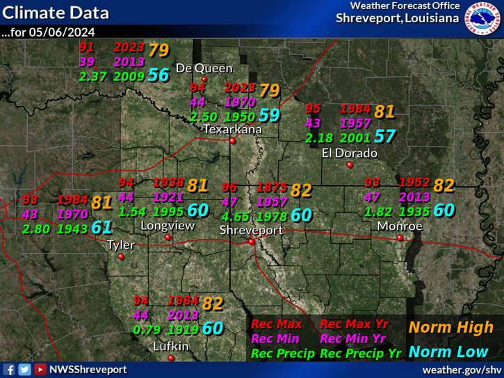
Climate
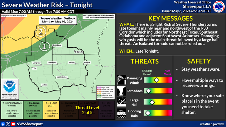
There is a risk for severe thunderstorms starting late Friday and continuing through the weekend. The severe risk expands to include a larger part of the region on Sunday. Stay tuned to the latest forecast, and review your severe weather safety plan with this potential threat increasing into this weekend.
The threat for heavy rainfall returns across the Four State Region as we head into the weekend. Multiple rounds of strong to severe storms moving over the same locations will support the the threat for possible flooding.
A chance for showers and thunderstorms along and north of Interstate 30 overnight. Can't rule out a strong to severe thunderstorm near daybreak.
Expect overnight low temperatures to range from the mid to upper 60s, with mostly cloudy skies and breezy south winds.
| Latest Text Product Selector (Selected product opens in a new window) | |
Current Weather Observations... | |||||||||||||||||||||||||||||||||||||||||||||||||||||||||||||||||||||||||||||||||||||||||||||||||||||||||||||||||||||||||||||||||||||||||||||||||||||||
|


 Regional Radar
 Shreveport Radar
 Weather Map
 Follow us on YouTube