

LOADING...
- 2011
- 2012
- 2013
- 2014
- 2015
- 2016
- 2017
- 2018
- 2019
- 2020
- 2021
- 2022
- 2023
- Major Floods
- Major Winter Storms
- Major Severe Thunderstorm Events
- Other Sources
|
|
January 12: Nor'easter
January 24: Arctic Blast
February 1-2: Winter Storm
February 19: High Winds
February 25: Winter Storm
March 6-7: Winter Storm, Flooding & Ice Jams
March: River Flooding & Ice Jams
April 28: EF1 Tornado - Frankfort NY Herkmier County
April-May River Flooding
-
Hydrographs
-
Brief summary of flood of April 27 - May 2, 2011 - US Geological Survey
May 26: Severe Weather
May 28: Flash Flooding & Severe Weather - Warren County
June 1: Severe Weather - Large /Historical Hail
-
Local Storm Reports
-
Pictures Large Hail: East Windsor MA Berkshire County & Shaftsbury VT Bennington County
-
NWS Storm Surveys - Tornadoes in Massachusetts - NWS Boston/Taunton
June 8: Severe Weather mainly hail
June 9: Severe Weather including Tornado & Microburst Litchfield County
July 20-23: Heat Wave
July 26: Severe Weather including Microburst Colonie, NY
August 19: Severe Weather
August 21: Severe Weather
Tropical Storm Irene: August 28
-
Rainfall Reports
-
Maps of 24-hour precipitation ending at 8 am on: August 28th & August 29th
-
Peak River Crests USGS gages
-
Local Storm Reports
-
Peak Wind Gusts
-
Post Tropical Cyclone Report
September 4: EF1 Tornado - Montgomery & Schenectady Counties
Remnants Tropical Storm Lee: Flooding - September 5-8
-
Local Storm Reports
-
Rainfall Reports
-
Maps of 24-hour precipitation ending at 8 am on: Sept 5th, Sept 6th, Sept 7th & Sept 8th
September 22: EF0 Tornado - Montgomery County
First Snowfall 2011-12 Season: October 27-28
Early Season Nor'easter: October 29-30
February 29-March 1: Snowstorm
May 16: Severe Weather
May 29: Severe Weather - Large Hail
September 8: Severe Weather
September 18: Damaging Winds & Torrential Rains
SANDY: October 29
-
Local Storm Reports
-
Peak Winds
-
Rainfall Reports
-
24-hour Precipitation ending 8am EDT October 30th
-
Tidal Flooding up the Hudson River: at Poughkeepsie NY & at Albany NY
-
Advisory Archive - National Hurricane Center
-
Precipitation Graphics - National Hurricane Center
November 7: Nor'Easter
December 26-27: Heavy Snowfall & Mixed Precipitation
February 8-9: Northeast Blizzard
March 7-8: Winter Storm
March 18-19: Winter Storm
May 21: Severe Weather
May 22: Severe Weather & Flash Flooding
May 29: Severe Weather, Tornadoes & Flash Flooding
-
SPC Storm Reports - Local Reports
-
Local Radar - Reflectivity Loop
-
NWS Storm Surveys:
June 2: Severe Weather
June 14: Flash Flooding - Schoharie County
June 23: Flash Flooding - Herkimer County
-
Local Storm Reports
-
Local Radar - Reflectivity Loop
-
Map of 24-hour Precipitation ending at 8 am EDT June 24th
-
Hydrographs: West Canada Creak at Kast Bridge & Mohawk River at Little Falls
June 24: Severe Weather & Flash Flooding
June 28: Flash Flooding - Herkimer & Montgomery counties
-
Local Storm Reports
-
Rainfall Reports
-
Map of 24-hour Precipitation ending at 8 am EDT June 28th
-
Hydrographs: West Canada Creak at Kast Bridge & Mohawk River at Little Falls
June 30: Severe Weather & Flash Flooding
July 1: Flash Flooding - Columbia, Dutchess, Ulster, Herkimer & Montgomery counties
July 2: Flash Flooding - Saratoga & Windham counties
July 19: Severe Weather
July 14-20: Heat Wave
August 9: Flash Flooding - Dutchess, Ulster, Berkshire & Litchfield counties
September 11-12: Severe Weather, Flash Flooding & Heat
-
September 11th: SPC Storm Reports & Local Reports
-
September 12th: SPC Storm Reports & Local Reports
-
Map of Maximum Temperatures September 11th
October 7: Severe Weather
-
SPC Storm Reports - Local reports
-
Local Radar (Reflectivity) @ 102 pm, 203 pm, 303 pm, 404 pm & 502 pm
December 14-15: Winter Storm
January 1-3: Long Duration Snowstorm
February 5-6: Significant Winter Storm
February 13-14: Exceptional Winter Storm
March 12-13: Heavy Snow & Ice
May 22: Severe Weather & EF3 Tornado - Schenectady & Albany counties
May 27: Microburst Litchfield County Connecticut
June 3: Severe Weather & Flash Flooding
-
SPC Storm Reports - Local Reports
-
Rainfall Reports
-
Map of 24-hour Precipitation ending at 8 am EDT June 4th
June 17-18: Widespread Thunderstorm Wind Damage
June 25: Severe Weather & Flash Flooding
-
SPC Storm Reports - Local Reports
-
Rainfall Reports
-
Map of 24-hour Precipitation ending at 8 am EDT June 26th
July 2: Widespread Severe Weather
July 3: Significant Severe Weather
July 8: Significant Severe Weather & EF0 Tornado - North Creek Warren County
July 9: Severe Weather
July 13: Severe Weather
July 23: Severe Weather
July 27: Severe Weather, Flash Flooding and Tornado & Microburst - Berkshire County
-
NWS Storm Survey - SPC Storm Reports - Local Reports
-
Map of 24-hour Precipitation ending at 8 am EDT July 28th
July 28: Severe Weather & Flash Flooding
August 5: Severe Weather (Lake George Area/Capital District) & Flash Flooding (Albany/Latham)
August 20-22: Flash Flooding - Montgomery County
-
Local Reports
-
Rainfall Reports
-
Map of 24-hour Precipitation ending at 8 am EDT August 21st
-
Map of 24-hour Precipitation ending at 8 am EDT August 22nd
November 26-27: Early Season Nor'easter
December 9-11: Slow Moving Coastal Storm
-
Final Snowfall: Reports & Map
-
Round #1 Snowfall: Reports & Map
-
NESIS Category 1 - Notable
|
|
January 26-27: New England / Long Island Blizzard
-
Snowfall Map - Local Area
-
Snowfall Map - Regional
-
Zoomed in on snowfall gradient
-
NESIS Category 2 - Significant
January 30: Bitterly Cold Temperatures & Dangeroulsy Low Wind Chills
February 2: Snowstorm
February 3: Bitterly Cold Temperatures & Dangeroulsy Low Wind Chills
February 7-9: Snowstorm
February 13: Bitterly Cold Temperatures & Dangeroulsy Low Wind Chills
February 14-15: Snowstorm
February 20: Bitterly Cold Temperatures & Dangeroulsy Low Wind Chills
February 24: Bitterly Cold Temperatures & Dangeroulsy Low Wind Chills
February 2015:
-
Albany NY: 4th Coldest Month, 2nd Coldest February & 5th Snowiest February
-
Glens Falls NY: 4th Coldest Month & Coldest February
-
Poughkeepsie NY: 2nd Coldest Month & Coldest February
-
Temperature Anomaly: Maximum Temp & Minimum Temp
-
Mean Temperature
June 9: Microburst & EF0 Tornado Scotia New York (Schenectady County)
-
NWS Storm Survey: Microburst & Tornado
-
SPC Storm Reports - Local Reports
-
Radar Loop
June 12: Severe Thunderstorms
-
SPC Storm Reports - Local Reports
-
Supercell Guilderland NY - photo credit Ian Lee NWS Albany
-
Surface Maps: 5 pm & 11 pm
June 23: Severe Thunderstorms
July 19: Severe Thunderstorms
July 24: Severe Thunderstorms
August 3: Microburst Fort Plain New York (Montgomery County)
August 4: Severe Thunderstorms (Hail)
December 28-29: Wintry Mix
-
First Measurable Snowfall of the Season
-
Snowfall-Sleet and Ice Reports
-
2nd Most Consecutive Days bewteen Measurable Snowfalls
|
|
January 23: Nor'easter / Blizzard
-
Snowfall Map - regional view
-
Visible Satellite showing cutoff of snowfall across area
-
RSI Category 5 (Extreme) for the Northeast
-
NESIS Category 4 - Crippling
February 12-14: Bitterly Cold Temperatures & Life-Threatening Cold Wind Chills
February 23-26: Heavy Rainfall, Flooding, Severe Weather, Snowfall and Strong Wind Gusts
-
Rainfall Map
-
Public Information Statements:
April 4: Late Season Snowfall
April 7: Damaging Convective Wind Event: Capital District & Saratoga/Glens Falls area
June 20-21: Nocturnal Severe Thunderstorms: Herkimer & Fulton counties
July 14: Severe Thunderstorms: Capital District
July 15: Severe Thunderstorms: Mohawk Valley & Capital District
July 1: Severe Thunderstorms: greater Capital District & mid-Hudson Valley
July 16: Isolated Severe Thunderstorm: Ulster Couty
July 18: Severe Thunderstorms
August 12: Severe Thunderstorms
August 13: Widespread Severe Thunderstorms
August 16: Severe Thunderstorms: western Adirondacks
September 11: Severe Thunderstorms: Columbia, Berkshire & Litchfield counties
October 22: First Snowfall of the Season
October 26-27: Heavy Wet Snowfall (first widespread measurable snowfall)
November 20-22: Synoptic, Lake Effect & Upslope Snowfall
December 11-12: Snowfall
December 14-15: Lake Effect, Strong Gusty Winds & Cold
December 17: Snowfall
December 29: Snowfall
|
|
January 7: Snowfall
January 23-24: Mixed Precipitation Storm
January 27-29: Heavy Lake Effect
Feburary 1-2: Heavy Lake Effect
February 7-8: Mixed Precipitation
Feburary 9: Snowstorm
Feburary 12-13: Snowstorm
Feburary 25: Severe Weather & Record Warmth
March 14: Nor'easter / Blizzard
-
Local Snowfall Map
-
New York State Snowfall Map
-
Snowfall Reports
-
Record Daily Snowfall for Albany
-
One of the Top 10 Greatest March Snowstorms for Albany
May 18: Severe Thunderstorms
May 31: Severe Thunderstorms
June 30: Broadalbin Tornado and Severe Thunderstorms
July 1: Flash Flooding and Severe Thunderstorms
October 29-30: Damaging Winds, Heavy Rainfall and Flooding
December 12: Snow and Mixed Precip
December 25: Christmas Snow
|
|
January 4: Snowfall
February 7: Snowfall and Mixed Precip
March 2: Nor'easter
March 7-8: Nor'easter
March 13-15: Nor'easter and March 1-15 Snowfall Totals Map
May 4 Severe Thunderstorms
May 15 Severe Thunderstorms/Tornadoes
|
|
January 19-20: Snowfall
January 24: Heavy Rain and Flooding
February 25th: Damaging Winds
June 26th: Severe Thunderstorms
October 31-November 1: Record Flooding and High Winds
December 1-3: Major Winter Storm
|
|
May 15: Severe Thunderstorms & Wilton Tornado
August 4: Tropical Storm Isaias
October 7: Derecho
December 16-17 Winter Storm
|
|
April 21, 2021: Tornadoes
July 2021: Heavy Rain and Flooding
September 1-2, 2021: Tropical Cyclone Ida
|
|
|
|
February 3-4, 2022: Winter/Ice Storm
April 7-8, 2022: Heavy Rain and Flooding
April 18-19, 2022: Late Season Winter Storm
July 12-13, 2022: Severe Weather
December 15-17, 2022: Nor'easter
|
|
February 1857
Highest flood ever recorded in Albany, 21.71 feet, caused by ice jammed on the sandbars south of the city.
March 1913
Major flooding in the Northeast. Highest water on record for the Hudson River from Hadley and Glens Falls south to and including Troy. Stages of 29.7 feet on the Hudson River at Troy, 21.45 feet on the Hudson River at Albany, 228.9 feet on the Mohawk River at Schenectady, and around 19 feet on the Mohawk River at Little Falls.
March 28, 1914
Flood of Record at Schenectady, 232.9 feet, water reached Broadway and flooded the former American Locomotive Plant on Maxon Road. Caused by an ice jam.
November 3-5, 1927
Disastrous flooding in New England with devastation over the northern 2/3 of Vermont. Floods of record for White, Winooski, Lamoille, Missisquoi rivers and Otter Creek. Flood of record for Batten Kill, 17.7 feet, and major flood for Hoosic River, 18.8 feet, also caused a significant flood on the Hudson River at Albany, 15.96 feet. Flooding was the result of rains from the remains of a late season hurricane.
March 12 -18, 1936
Major flooding throughout the Northeast as a result of extremely heavy snowpack and a double dose of spring rains. Caused highest stages on Hudson River at Troy, 29.5 feet and Albany, 17.9 feet, since completion of Conklingville Dam. Flood of Record on Connecticut River at Thompsonville Connectciut; just north of Hartford.
The Great Hurricane of 1938 "Long Island Express" (September 22, 1938)
One of the most destructive and powerful storms ever to strike Long Island and southern New England. Severe flooding occurred across almost all of the region's rivers. Most severe across New England. The Hudson River at Albany reached 16.5 feet.
October 2, 1945
Severe flood in upper Mohawk area including record flood on East Canada Creek at Dolgeville, 15.1 feet. Record flow on West Canada Creek at Kast Bridge, 8 feet, nearly destroyed the Daniel Greene Factory in Dolgeville.
December 31, 1948 - January 2, 1949
Major flooding occurred in the Hudson, Housatonic and Connecticut River drainages as a slow moving storm brought heavy rain. Liquid equivalent precipitation (mostly rain) was 5-12 inches across these river basins. Rainfall was heaviest December 29 into December 31. Snowmelt and ground frost were limited due to unseasonably warm temperatures during the late fall and early winter. Precipitation changed to snow at the tail end of the storm. Major flooding along the Hudson River at Albany. The famed New Years ice storm and flood which caused the flood of record on the Hoosic River at Kinderhook along with other streams. 17.5 feet crest in Albany. Involved a significant sleet storm as well as rain. Major flooding occurred in the Hudson, Housatonic and Connecticut River drainages as a slow moving storm brought heavy rain. Liquid equivalent precipitation (mostly rain) was 5-12 inches across these river basins. Rainfall was heaviest December 29 into December 31. Snowmelt and ground frost were limited due to unseasonably warm temperatures during the late fall and early winter. Precipitation changed to snow at the tail end of the storm. A flood of record occurred on the Hoosic River at Kinderhook with major flooding along the Hudson River at Albany with a crest of 17.5 feet on January 1st).
Hurricanes Connie and Diane, August 1955
Back to back hurricanes, Connie and Diane made landfall on the coast of North Carolina only 5 days apart, significantly impacting southern New England. Hurricane force wind and storm surge caused only minor damages, but rainfall created devastating impacts. Significant rainfall amounts from Connie set the stage for the devastating floods caused by the rainfall from Diane. Connie dumped over 10 inches of rain at Slide Mountain in the Catskills of New York brought the Esopus Creek only up to 12 feet. Five days later, on August 17th, Hurricane Diane came right into the Hudson River Valley, which resulted in the worst flood disaster in the Lower Hudson Valley of New York and in the State of Connecticut. Diane dropped over 19 inches of rain at Westfield MA. Floods of record on the Housatonic River at Gaylordsville, 18.6 feet, Stevenson, 24.5 feet, Shepaug, 17 feet, and Tenmile River, as well as Rondout and Wappingers Creek. The Village of Ellenville was nearly washed off the map, while the riverfront in Kingston was under nearly 4 feet of water. Eight states were declared federal disaster areas. Known as the $1 billion hurricane (1955 dollars), Diane caused record flooding in the Lower Hudson Valley of New York and in the State of Connecticut, including along the Housatonic, Mad, Naugatuck and Farmington rivers.
October 1955
Severe flooding on the Schoharie Creek caused by a slow-moving coastal storm with produced 16 to 18 inches of rainfall over the Tannersville area and devastation in the Schoharie Valley (Burtonsville 12.4 feet, second highest of record).
Hurricane Anges, June 1972
Agnes made secondary landfall near New York City as a strong tropical storm then merged with a low pressure system resulting in heavy rains. Flooding that began in Westchester County on June 19, was followed by widespread flooding in the Southern Tier and Finger Lakes on June 23. This was a devastating flood event in Elmira and Corning, NY. This storm produced widespread heavy rains of 6 to 12 inches across Pennsylvania and western New York. Although more than 10 inches of rain was recorded at Slide Mountain, NY, flooding along the Esopus Creek was relatively minor. At Great Sacandaga Lake, the water level reached a record height for the 42-year history of the lake.
September 1975
Hurricane Eloise, caused significant flooding on the Susquehanna River and in parts of Catskills.
March 13-15, 1977
Worst regional flood across the area since the New Years Flood nearly 30 years earlier. An early warm spell with temperatures into the 70s and 80s, combined with a heavy snowpack, and 3 inches of rain produced a record flood on the Mohawk River at Little Falls and near record flood on Kaydeross in the Saratoga area. Ice jams caused flooding along many small creeks and along the Connecticut River in Windham County, VT. The Pontoosuc Dam in Pittsfield, MA was threatened by overtopping but held. Ramps to new Interstate 787 in downtown Albany were flooded, and the current in the Hudson River undermined the Green Island Bridge causing it to collapse into the river on March 15 around 2:30 PM with, miraculously, no fatalities or injuries.
January 1978
Severe ice jam in Prattsville NY effectively blocked the streamflow from the full reservoir. Widespread flooding in the region with an entire herd of dairy cattle drowned in their barn.
March 1979
Severe ice jamming caused flooding of many rivers including the Hudson, Mohawk, Susquehanna, and Chenango Rivers, as well as the Schoharie Creek.
November 1979
Severe flash flood on the Boquet and the Branch in and near Elizabethtown. Numerous washouts on the road between Elizabethtown and Keene caused the deaths of four Olympic Bobsled hopefuls.
March 1980
The "Great Catskill Toilet Flush" with around 10 inches of rain on nearly bare and frozen ground which led to rapidly developing and severe floods on Schoharie, Catskill, and Esopus Creeks. A fatality occurred when a motorist ignored a roadblock.
February 1981
Severe ice jamming on Mohawk River which nearly flooded the New York State Thruway (I-90) near Fonda.
April - May 1983
"Spring Monsoon" with over 18 inches of rain over two months in Ellenville and New York City. Sacandaga Reservoir spilled over on May 1st for the first time since the project was completed in 1930.
April 4-6, 1987
Snowmelt and large rainfall amounts on March 31st and April 4th-7th led to flooding from eastern Pennsylvania and New Jersey, northeast across eastern New York into much of New England. Severe flooding occur on the Mohawk River and in the Catskills. Damage from flooding was widespread in this area and led to numerous evacuations. 500 people were evacuated from their homes in the Berkshires in western Massachusetts. In New Milford, CT, the Housatonic River ravaged through town damaging many roads. In Vermont, Corp of Engineers reservoirs spilled for the first time in their history. On the morning of April 5, the New York State Thruway Bridge over the Schoharie Creek suddenly collapsed. At least 10 people died when their vehicles plunged into the flood swollen creek.
February 1990
Severe Ice jam on the Ausable East Branch with much of Ausable Forks village under water.
January 19-20, 1996
The Northeast Floods of January 1996 were the result of a very rapid snowmelt punctuated by a short but intense rainfall; 2 to 4 inches of rain. What made this event so unusual was the nature and the intensity of the snowmelt, combined with the intense rainfall for this time of year, over such a large geographical area. The flooding was compounded by ice movement and jamming in many of the rivers and streams. The floods were described by some as a "flash flood" for main-stem rivers due to the unprecedented rates of rise recorded during this event. Record flooding on Schoharie Creek and significant floods on Mohawk River at Schenectady, and on the Hudson at Albany (15.5 feet; greatest since New Years 1949).
Hurricane Bertha, July 1996
Hurricane Bertha was an early season Category 2 storm when it made landfall on the coast of North Carolina on July 12, 1996. The storm continued up the east coast into southeast New England. Heavy rains of 5 to 7 inches were reported in the Lower to Mid Hudson Valley and in the Catskills. Due to heavy precipitation flash flooding occurred in Columbia and Dutchess counties causing states of emergency. In Albany County several roads and small streams were flooded. The Normans Kill Creek spilled over its banks. Flooding was most widespread in the Towns of Bethlehem, New Scotland and Rensselaerville. High winds contributed to scattered power outages across Eastern New York State. Across Berkshire (MA) and Litchfield (CT) counties rain totals ranged from 3 to 5 inches and minor river flooding occurred across the area.
January 1998
A catastrophic ice storm and flood event struck northern New England and northern New York during the first two week of January 1998. Heavy rain associated with a warm moist air mass overspread a shallow but dense layer of cold air producing ice accumulations in excess of 3 inches. Heavy rainfall, exceeding 4 inches in some areas, combined with significant runoff from melting snowpack to produce record flooding. NWS: Service Assessment - The Ice Storm and Flood of January 1998.
Tropical Storm Floyd- September 1999
Tropical Storm Floyd dumped very heavy rains, 3 to almost 12 inches, across the region. National Hurricane Center - Tropical Cyclone Report. NWS: Service Assessment - Hurricane Floyd Floods of September 1999.
September 17-18, 2004
The remnants of Hurricane Ivan dumped dumped heavy rains across the region, up to 6 inches in some locales.
January 2005
In mid January warm, breezy conditions combined with high dew points melted most of the snow across the area. Runoff from the melt combined with runoff from heavy rains to cause some flooding and flash flooding. The stage below Stevenson Dam on the Housatonic was the highest since 1960. The stage on the Wappingers Creek at Wappingers Falls was the highest since 1987.
April 2005
Combination of high pre-storm flows, rain plus snowmelt. A slow moving storm moved up through the Appalachians and into the Northeast, producing an extended period rainfall on April 2-4th. The heaviest rain and worst flooding occurred in Ulster and Greene Counties. Upslope flow enhanced rainfall amounts in the Catskills, where generally 3 to 6 inches fell. Flood of record occurred on the Esopus Creek (Mount Marion 26.24 feet). U.S.G.S. estimated it as 100 year event for the Upper Hudson Basin. Sacandaga Lake and Indian lake were nearly empty and were able to cut half the peak flow off the Hudson. As a result moderate as opposed to devastating flooding resulted on the Hudson River.
Flash Flooding: Warren County - June 13, 2005
Thunderstorms moving from west to east repeatedly affected the same areas of central Warren County between about 6 pm and 9 pm with over 6 inches of rain fell at Bolton Landing. Flash flooding which washed out a portion of the Northway between Exit 23 and 24.
October 2005
According to the Drought Monitor of September 27th, 2005, the southern part of the Albany Hydrologic Service Area was in a moderate drought. This changed dramatically in October 2005 as two rain events dumped a total 1 to 2 feet of rain across the driest areas. The first event, October 7-9th, the remnants of Tropical Storm Tammy interacted with a cold front; then a stationary low pressure sat south of Long Island and brought periods of heavy rain to New York and New England the 12th through 14th. The worst flooding occurred in Dutchess County, New York and Litchfield County, Connecticut where moderate to major flooding was reported.
End of June 2006
Widespread flooding in the Mohawk and Hudson river basins and eastern Catskills was occurred. Flooding was most severe along the Mohawk River and its tributaries. On Tuesday, June 27th, a frontal boundary stalled across the region. The boundary extended from southern Quebec across central New York and to Florida. A weak disturbance, tropical in origin, moved along the boundary across southeast New York Wednesday morning, June 28th. A strong low level jet also developed which transported more tropical moisture into central and eastern New York. Rainfall amounts from June 26th through the 30th ranged from as little as around an inch up to around a foot in the eastern Catskills. Departures from normal for June 2006.
April 15-16, 2007
An intense and powerful storm brought flooding rains and a heavy wet snowfall to the region. Rainfall amounts of 6 to 8 inches were reported across the eastern Catskills, mid Hudson Valley and western New England resulting in widespread flooding. Snowfall accumulations of 1 to 1 1/2 feet were reported across the southern Adirondacks, eastern Catskills, Berkshires and southern Green Mountains with resulting power outages.
Low pressure system developed over the deep south by Friday morning, April 13th. The low pressure system then track eastward across the southeastern United States early in the weekend. By Sunday morning, the low center was over the Carolina and precipitation had spread northward across the local area. The storm rapidly intensified as it headed northeast into the mid Atlantic Region Sunday, April 15th. The storm was a its deepest around sunrise Monday, April 17th, with a surface pressure of 28.61 inches (969 millibars) over Nassau County (Long Island) New York. The low moved little throughout the day Monday and finally began to drift southeastward Monday night.
January 25-26, 2010
Flooding occurred across East Central New York and adjacent western New England on January 25th and 26th from a combination of rainfall and snowmelt. Rain was heaviest in the Catskill Mountains where 3 to 5 inches of rain fell. Elsewhere, just under 1 to around 2 inches of rain was reported. There was some snow melt, but the mountains did not lose their snow cover. Flash flooding also occurred due to heavy rain on frozen ground. In addition, some ice jam flooding was reported. Some mud and rock slides were also reported. River flooding was widespread and ranged from minor to moderate. Significant ice jam flooding was reported on January 26th in the Town of Dolgeville, NY along the East Canada Creek (Herkimer and Fulton Counties) and in Rotterdam Junction, NY and Scotia, NY along the Mohawk River in Schenectady County. Minor ice jam flooding was reported along the Mohawk River in Schenectady, NY. Also, minor tidal flooding occurred along the Hudson River in the vicinity of Poughkeepsie, NY.
September 30 - October 1, 2010
The remnants of Tropical Storm Nicole moved northward along a nearly stationary boundary along the east coast bringing abundant tropical moisture into the region. A very strong low level jet help fuel the heavy rainfall which lead to widespread flooding and produced strong gusty southerly winds with resulted in damage to trees and power lines. Rainfall reports ranged from just over 3 inches up to 9 inches across east central New York and adjacent western New England. At the Albany International Airport daily rainfall records were set for September 30th and October 1st. Widespread urban and small stream flooding was reported. Major flooding occurred on the Esopus Creek at Cold Brook and on the Schoharie Creek at Prattsville with widespread minor river flooding occurring along portions of the Esopus Creek, Rondout Creek, Schoharie Creek, Mohawk River, West Canada Creek, Hudson River, Sacandaga River and Still River.
Prior to this rainfall deficits were running around 6 to 9 inches across east central New York and western New England. There were moderate drought conditions across southern Vermont, the Berkshires and northwestern Connecticut into the Taconics of New York with abnormally dry conditions across much of east central New York. Drought conditions eased after the event.
March 11-13, 2011
The combination of the heavy rainfall and runoff from the snowmelt due to mild temperatures caused flooding of rivers, streams, creeks, roads, and some urban low lying areas. Moderate flooding occurred along the Esopus and Schoharie Creeks. Generally 1 to 3 inches fell with locally higher amounts of 4 to 5 1/2 inches reported across portions of the eastern Catskills. An ice jam formed on the Mohawk River which resulted in flooding along the river in parts of Albany, Saratoga and Schenectady counties. The combination of increased flow from the upper Mohawk Basin and out of the Schoharie Creek due to runoff from the heavy rainfall and snowmelt caused ice to move. On Friday, March 11th, an ice jam in place in Schenectady County at Lock 9 and Lock 8 broke up and moved downstream. Another ice jam formed and extended from the Twin Bridges back towards Lock 7 in Niskayuna and caused flooding of some properties and houses along the river. The ice jam broke up and moved down river without any additional flooding on Sunday, March 13th.
Record flooding occurred on the Hudson River at North Creek as a result of an ice jam. The ice jam extended from about 1 1/2 miles downriver from the Route 28N Bridge and northward about 3 miles. An ice jam began to form on Monday, March 7th, near the Route 28N Bridge in North Creek after heavy rainfall and snowmelt. Water backed up from the ice jam began flooding Old River Road early Thursday morning, March 10th, prompting the evacuation of some residents and the closure of the road. The water began to recede early Sunday afternoon, March 13th, when the ice jam released and moved downstream. The ice jam moved down river and ripped trees from the river bank. The jam became lodged along the Route 418 Bridge in the town of Thurman Sunday evening, March 13th, with water levels receding behind the jam.
Tropical Storm Irene: August 28, 2011
The storm made tertiary landfall near New York City and moved north northeast over Vermont. It produced widespread, devastating flooding in Vermont, New Hampshire, New York, and New Jersey. The observed sudden and tremendous increases in river stages in a 2–3 hour timeframe were more characteristic of flash flooding in small streams than expected behavior from main stem rivers. A rainfall maximum of over 18 inches was recorded in the Catskills. In addition to the widespread and significant flooding, tropical storm force winds took down many trees and resulted in nearly one million people without power, some for up to a week. Several towns in Vermont and in the Catskill Mountains in southeast New York were entirely isolated and eventually received airlifted disaster supplies until roadways were made passable again. Interstate 88 in New York was closed from Exit 22 to 24 from 28 August 2011 through 31 August 2011 due to flooding concerns, including evaluation of a bridge affected by high water (later deemed to be safe). Portions of Interstate 87 southbound (New York State Thruway) were closed on 28 August 2011 for flooding as well as for downed trees and power lines.
Heavy to extreme rainfall resulted catastrophic flooding. Rainfall amounts were generally 4 to 12 inches with locally up to 18 inches. Maps of 24-hour precipitation ending at 8 am on: August 28th & August 29th. Peak River Crest USGS gages. Peak Wind Gusts. Local Storm Reports. Post Tropical Cyclone Report. National Hurricane Center - Tropical Cyclone Rerport. NWS: Service Assessment Hurricane Irene August 21-30, 2011
Remnants of Tropical Storm Lee: September 5-8, 2011
Heavy rainfall, combined with saturated soil from the excessive rains which fell in late August associated with the passage of Irene, led to widespread minor to moderate flooding on rivers, as well as small streams and creeks across eastern New York and adjacent western New England. Rainfall amounts of just over 2 inches to 9 inches occurred. Some major flooding did occur across portions of the western Mohawk River. In addition, flash flooding occurred across portions of the eastern Catskills and western Mohawk River Valley. Maps of 24-hour precipitation ending at 8 am on: September 5th, September 6th, September 7th, and September 8th. National Hurricane Center - Tropical Cyclone Report.
Flash Flooding: Schoharie County- June 14, 2013
On June 14th, On showers and thunderstorms moved (trained) over areas that had received significant rainfall over the past several weeks from convection. Flash flooding occurred with the town of Middleburgh in Schoharie County the hardest hit as small creeks and tributaries (surprisingly not the Schoharie Creek itself) (combined with elevation influences) resulted in much of the town experiencing flash flooding. Flash flooding was also reported in Sharon Springs, Schoharie, Richmondville, and Cobleskill. A group of elementary students at a school in Middleburgh were sheltered in place during the flooding, since there was no way to get into Middleburgh during the height of the flooding.
Flash Flooding: Herkimer County- June 23, 2013
On June 23rd, slow-moving thunderstorms moved over the same areas (trained) of southern Herkimer County which were already saturated from previous rainfall events over the last several weeks. Flash flooding occurred with the towns of Middleville and Herkimer hardest hit with several road washouts, reports of debris in roadways, and homes being flooded. Little Falls also experienced flash flooding with roads being washed out. Homes in Kast Bridge were flooded as well as roads being closed. Multiple roads were also washed out in Fairfield. West Canada Creek at Kast Bridge and Mohawk River at Little Falls.
Flash Flooding: Herkimer & Montgomery counties - June 28, 2013
After several weeks of very wet weather, the ground across the region was already quite saturated due to recent flooding making the region susceptible to flooding. On June 28th, heavy rainfall occurred across the Mohawk Valley and western Adirondacks with rainfall fell at rates of nearly one inch per hour at times with a On total rainfall of three to five inches. This led to significant flash flooding across both the Mohawk Valley and Adirondacks. Many roads were washed out and closed, including a portion of the New York State Thruway between exits 29 (Canajoharie) and 29A (Little Falls). In addition, urbanized areas along the Mohawk River experienced dangerous amounts of flooding. The entire town of Fort Plain was under water and many swift water rescues had to take place. The West Canada Creek at Kast Bridge and the Mohawk River at Little Falls both experienced major flooding.
Flash Flooding: Herkimer, Fulton, Warren, Washington & Rensselaer Counties - July 1, 2017
Several rounds of thunderstorms moved across the area mainly along and north of Interstate 90. The storms resulted in torrential rainfall and flash flooding in portions of Herkimer, Fulton, Warren, Washington, and Rensselaer Counties. It was the second straight day of heavy rainfall for some of these areas. The village of Hoosick Falls was hit particularly hard by flash flooding, with many residences experiencing basement and first-floor flooding and several roads washed out as Woods Brook overwhelmed its flood protection system and coursed through the town. A state of emergency was declared for the village, where an estimated $300,000 in damage occurred. Across Rensselaer County, flooding resulted in an estimated $3.6 million in damage. Rainfall amounts up to 4 inches were recorded in Washington County where several roads were washed out. Neighboring Warren County estimated $1 million in flood damage. In Herkimer County, a mudslide closed a state highway, and people had to be evacuated from locations in the villages of Herkimer and Frankfort due to rising water. Several area rivers reached minor and moderate flood stage, including the Mettawee River at Granville and West Canada Creek at Kast Bridge which crested just below major flood stage.
January/February 2018: Ice Jam Flooding
Frigid temperatures over a two week period from late December 2017 into early January 2018 very quickly formed thick ice on rivers across the local area. On January 12th, an unseasonably warm air mass coupled with heavy rain led to river rises which broke up the river ice and caused ice to jam in many locations. A dozen separate jams were reported with numerous other road closures reported due to ice jam flooding on smaller creeks and streams. The ice jam on the Mohawk River was the biggest ice jam seen in decades. The ice jam stretched up to 17 miles from Rexford to Crane Hollow in February. Flooding occurred in the Stockade district and water levels rose into the parking lot at Jumpin' Jacks from January 13-16. The ice jam mainly remained in place into late February and received a large amount of media and government attention. Two ice jams on the Housatonic River spanning a mile caused flooding in Kent, CT beginning on the morning of January 13th. Flood waters surrounded parked cars and an indoor ice rink on the Kent School and students were sent home as flood waters rendered the campus inaccessible. Waters continued to rise during the afternoon, surrounding houses and necessitating technical rescues of residents on Johnson Road and South Main Street. A total of 12 people in four homes were evacuated and a number of area roads were closed. Additional ice jams occurred on the Hudson River between Warrensburg and The Glen as well as on the Hoosic River near Buskirk. As the flood waters began to recede, a strong cold front passed through the forecast area, freezing many of the ice jams, and in some cases their associated floodwaters, in place. It was not until March 7 that the ice jam flood threat abated across the local area.
Halloween 2019 (October 31- November 1): Record Flooding and High Winds
A strengthening low pressure system moving from Ohio to Lake Ontario drew anomalous warmth and moisture northward on Halloween, with temperatures surging into the 60s and 70s over eastern New York and western New England. Showers across the southern Adirondacks and Mohawk Valley became steadier and heavier during the evening ahead of a strong cold front as the low continued to strengthen. Strong winds aloft mixed down to the surface as an intense line of showers developed along the front, resulting in sporadic wind damage over eastern New York and western New England. A large swath of rainfall totaling 2-5 inches occurred over the Mohawk Valley and southern Adirondacks (where October had been a very wet month already), resulting in flash flooding. The runoff caused rapid rises on area creeks and streams, with four river gages reaching record levels: West Canada Creek at Hinckley Dam, West Canada Creek at Kast Bridge, Mohawk River at Little Falls, and Sacandaga River at Hope. The three of these floods of record that were recorded at USGS streamgages West Canada Creek at Kast Bridge, Mohawk River at Little Falls, and Sacandaga River at Hope all are based on periods of record in the 100 year vicinity (99, 92 and 108 years, respectively), which is a significant period of record for streamgaging. The fourth flood of record was at a New York State Canal Corporation reservoir and this was the highest recorded elevation since reservoir storage began in 1914. There were also 5 moderate and 4 minor flood crests at river forecast points. The flooding was extensive over portions of the area, damaging numerous roads and structures and resulting in water rescues. There was one fatality as a result of the flooding.
Behind the cold front, strong gusty westerly winds developed and persisted into the afternoon November 1st. The winds gusted as high as 63 mph, resulting in numerous reports of downed trees and thousands of power outages.
Christmas 2020
A storm system brought mild air into the region along with moderate to heavy rainfall and gusty winds later Christmas Eve into early Christmas Day. Widespread minor flooding occurred with moderate to major flooding in the eastern Catskills. From December 24th through the 25th, widespread rainfall of 1 to 2 inches, with totals in the eastern Catskills ranging from one and a half to a maximum of 5.72 inches. Additionally, the warm temperatures led to significant snowmelt: 1 to 3 inches across much of the local area with up to 3 to 4 inches of melt in the eastern Catskills. As a result of this combined rainfall and snowmelt, major flood crests occurred at Mount Tremper on the Esopus as well as on the Schoharie at Prattsville and Gilboa Bridge. Farther down the Schoharie Creek, Breakabeen and Burtonsville experienced moderate flooding. Minor flooding occurred at 10 additional river forecast points.
Back to Past Weather Events Page
December 18-22, 1887
This storm stands as the 3rd greatest snowstorm for December and is one of the greatest ever for Albany. The winter of 1887-88 is the 2nd snowiest on record for Albany with 110.0 inches.
The Blizzard of 1888 (March 11-14, 1888)
The blizzard by which all others are measured. This storm formed over northern Georgia on the 11th as an offshoot of a storm that was passing through the upper Great Lakes. The storm moved off the Delaware coast on the 12th and moved to southern New England on the 13th. The storm stalled making a tight loop and circled back to sea passing east of Cape Cod on the 14th.
Flurries started around 10:30 am with the light snow beginning around 3 PM on Sunday the 11th, accumulating to near 3 inches by midnight. The snow intensified overnight and there was 18 inches on the ground by daybreak on Monday the 12th. Moderate to heavy snow continued throughout the day accumulating to 33 inches by midnight. Snow continued on and off through Tuesday the 13th, adding roughly another foot, until finally ending around 3 AM on the 14th. After 60 hours a total snowfall of 46.7 inches was reported, but the drifts were significantly higher. This storm stills holds the record snowfall for a storm for Albany. March 1888 stands as the 2nd snowiest month on record for Albany. The winter of 1886-87 is the snowiest on record for Albany with 94.2 inches.
The city of Albany was virtually shut down. There were no coal deliveries, and thus, no heat. Doctors were unable to make house calls, and it took many days to clear the snow off of country roads to make them passable. At the time it was called the "worst storm in living memory," and it still holds the distinction of the worst winter storm on record in many areas of the northeast.
February 14, 1914
Very cold and windy with blizzard conditions. To the south of Albany 10 to 20 inches of snow fell with 20 to more than 30 inches accumualated across portions of eastern and central New York. In Albany 23.5 inches fell. This storm stands as the greatest snowstorm for February and one of the greatest ever for Albany.
December 13-15, 1915
Twenty-five to 35 inches of snow fell across eastern and southeastern New York. In Albany 24.7 inches of snow was measured. This storm stands as the 2nd greatest snowstorm for December and 4th greatest ever for Albany. The winter of 1915-16 is one of the snowiest on record for Albany with 94.7 inches.
May 10, 1945
Many areas across the region saw snow accumulation. The 5.4 inches of snow recorded at Albany, made it the largest May snowstorm to date. 60,000 power outages were reported across the Capital District of NY from downed trees and wires. Some locations were without power for a few days. Largest number of power outages since ice storm of 1929. In the City of Albany alone, 10 DPW trucks were assigned to debris removal. Glens Falls reported 3 inches of snow. Locations in Western New England reported 3 to 8 inches of snow. In the hill towns, snowplows had to rescue stranded motorists.
The Great Appalachian Storm (November 24-25, 1950)
The rain and snow associated with the storm was not that great, but the winds were a different story. A very severe wind event occurred across the region as a storm rapidly deepened as it tracked inland along the eastern slopes of the Appalachians. The storm was situated between two very strong high pressure centers, one east of Labrador and another over the Mississippi Valley, producing a very tight pressure gradient. Gale to hurricane force winds were experienced throughout the area resulting devastating damage. A wind gust of 83 mph was recorded at Albany from the east between 6 and 7 pm (the strongest ever) with sustained winds of 50 to 60 mph. The storm was at its greatest intensity between 4 and 10 pm. Roads were impassable to fallen trees, fire towers, telephone and power lines were blown down across the region, and wind damage was extensive in New York State, totaling 20 million dollars at the time. Rain and snow fell across the region. Some places across southwestern New York received 20+ inches of snowfall. No snow fell in Albany however 1.08 inches of rain was reported with 7.78 inches of rainfall at Slide Mountain in the Catskills.
The Blizzard of '58 (February 15-16, 1958)
A coastal storm brought strong winds and heavy snow to the northeast. Over 30 inches of snow was reported across the Catskills and in western New England, with 17.9 inches at Albany making it the third greatest February storm. Travel of any sort became impossible, and drifting of the snow blocked most roads and highways and marooning many. Operation "Haylift" was instituted, where helicopters dropped food for stranded cattle.
The Blizzard of '64 (January 13-14, 1964)
Widespread 10 to 15 inches of snow across Albany Forecast Area, with up to 30 inches in Catskills, and around 20 inches in southern Vermont and the Berkshires. 15.4 inches reported at Albany, NY making it one of the top 10 greatest snowstorms from January. Winds gusting 50 to 60 MPH caused near zero visibility and snow drifts of 3 to 8 feet were reported. Route 9 in Vermont was closed from Bennington to Brattleboro. Winds downed trees and power lines in Massachusetts causing power outages.
Northeast Snowfall Impact Scale: Category 4 - Crippling
The Worst Ice Storm on Record (December 4-5, 1964)
Freezing rain caused ice accumulations of up to 1.5 inches and crippled east central New York. Many residents were without power for up to two weeks and schools had to be shut down for a week. Damage was estimates approached 5 million dollars. Temporary shelters were opened in Massachusetts and New York. Thawing of ice on December 11 caused additional power outages as wires snapped from sudden release of weight. Icing conditions extended from Buffalo to Boston. Worst glazing since December 29-30, 1942. During storm, precipitation was mostly snow in southern Vermont (6-10” reported) and plain rain in northwest Connecticut.
The Blizzard of '66 (January 29-31, 1966)
Intense coastal storm followed by heavy lake effect snows/squalls. This storm is not so much known for it's blizzard conditions, which produced a foot of snow at Albany on the 29th and 30th, but for the intense lake squalls that developed as arctic air streamed across Lake Ontario on the 30th and 31st. Oswego reported 75 inches inches, with some unofficial reports of around 100 inches in that vicinity. Rome, which is approximately 75 miles from Lake Ontario, received 41 inches.
Northeast Snowfall Impact Scale: Category 3 - Major
Post Christmas Snowstorm of 1969 (December 25-28,1969)
A foot of snow had already fallen on December 22nd, 1969, but this was outdone by another storm system which began moving northward along the east coast Christmas night. On the morning of the 27th, with 15 inches already on the ground at Albany, the storm stalled off the New England coast. It then began to move inland for a short period before heading back out to sea on the 28th. A total of 26.7 inches of snow fell at Albany, making it the greatest snowstorm for December and the 3rd greatest stormsnow on record. However, Vermont surpassed that, with 30 inches at Burlington and 44 inches at Waitsfield, southwest of Montpelier. In and around the Capital District, it was a heavy, wet snowfall, and the snow mixed with freezing rain at times. Snow removal became quite difficult, and some streets were not cleared for 3-4 weeks. The city of Albany public works continued round the clock snow removal for over a month before things returned near normal. Two million dollars were spent on snow removal, a record at the time. December 1969 stands as the snowiest month on record for Albany. In addition, a record low temperature was set in Albany on December 25th, 1969: -22 degrees.
Northeast Snowfall Impact Scale: Category 4 - Crippling
Thanksgiving Snowstorm of 1971 (November 24-25, 1971)
Heavy snow in Catskills and acorss the Upper Hudson Valley. This heavy snow began on the day before Thanksgiving and continued into Thanksgiving day. Albany picked up 22.5 inches with amounts up to 30" reported elsewhere. This storm turned the busiest travel day of the year into a nightmare, with many stranded travelers not making it to their destinations on Thanksgiving. This storm was the greatest November snowstorms on record and one of the greatest ever,
February 2, 1976 Flash Freeze and Brief Blizzard
At Albany, NY, the temperature fell from 41°F at midnight, to 1°F at 10:30 AM, with a 30 degree drop in the few hours before sunrise. Rain changed to snow and winds at Albany increased to 50 MPH with gusts to 67 MPH. Officially, only 3” of snow was measured at Albany, but visibility was near zero during morning commute. Roads were very icy and travel was seriously hampered. Two fatalities were reported; a man died from exposure to cold and another man was blown off a tug boat into the Hudson River and drowned. Winds downed trees and power lines and caused some power outages and isolated structural damage. Brief blizzard conditions occurred across New York State with blizzard conditions reported in Buffalo and New York City. A long stretch of the NYS Thruway was closed. Strong northwest winds also caused a record low tide in New York Harbor.
Blizzard of 1978 (February 6-7, 1978)
This storm is more well known for its impact on coastal New England and Long Island, but it still had quite an impact on eastern New York and western New England. The Green Mountains of Vermont were hit hard, with many areas reporting around two feet of snow. East Wallingford, near Rutland had 30 inches. The Catskills also had quite a bit, with Prattsville reporting 25 inches. Albany received 13.4 inches of snow. Wind also caused quite a bit of drifting of the snow. On the coast, Boston received 26.7 inches of snow. The storm also produced strong winds, Logan Airport reported an 83 mph gust and there was a report of 92 mph on Cape Cod. The winter of 1977-78 is one of the snowiest on record for Albany with 92.4 inches.
Northeast Snowfall Impact Scale: Category 3 - Major
April 6-7 1982
Shutting down highways, offices and schools this weather event is considered the worst April snowstorm in local history. The April snowstorm was accompanied by heavy snowfall, high winds, blizzard conditions and most notably; extensive thunderstorm activity. Most areas saw one to two feet of snow Albany received 17.7 inches of snow from this storm which stands as the greatest snowstorm for April for Albany. The winter of 1981-82 is one the snowiest on record for Albany with 97.1 inches. Wind gusts of 40 MPH were recorded in Rensselaer, NY while gusts of 70 to 80 MPH were observed in Massachusetts and Connecticut.
Northeast Snowfall Impact Scale: Category 2 - Significant
January Snowstorm of 1983 (January 15-16, 1983)
Although well-predicted, this classic nor'easter raised havoc across eastern New York and New England. Albany reported 24.5 inches with amounts of almost 30 inches reported in Saratoga County, but less than a foot in the lower Hudson Valley. Up to 20” of snow in the Berkshires with 12-18 inches in southern Vermont and Northwest Connecticut. For Albany, this storm is the greatest January snowfall on record and one of the greatest stormsnows. The heavy snow brought travel to a standstill across many locations, and may injuries were reported due to auto accidents.
Unprecedented Early Season Snowstorm (October 4, 1987)
Three inches up to about 2 feet of extremely wet snow fell across eastern New York and western New England resulting in many deaths and injuries and an enormous amount property damage. Snow to liquid ratios were as low as 3.5 to 1. The storm wreaked havoc on the area causing widespread power outages. The trees still had their leaves which was a major contributing factor to the number of trees and limbs that came down taking out power lines. Numerous branches and trees were felled taking down power lines with them, blocking roads and damaging houses. Albany was described as "looking like a war zone." Hundreds of thousands of people were without power; some for up to two weeks. It was the most snow that ever fell during the month of October in Albany and is the earliest measurable snowfall for Albany, 6.5; inches were reported. An updated case study of this storm was done by Finch and Frank (2010).
The Downslope Nor'easter (December 10-12, 1992)
This storm produced incredible snowfall totals across many mountainous locations, while barely having any effect on valley locations. Strong east winds caused the air to "downslope" off the Berkshires and Taconics, and "dry it out." Snowfall totals in the Berkshires ranged from 30 to 48 inches with drifts up to 12 feet. Schools were closed for a week and the national guard had to bring in heavy equipment to remove the snow. The Catskills and Helderbergs also got their share of snow with 18 to 39 inches reported. On Friday, December 11, at the height of the storm, the city of Albany received a half inch of snow with temperatures in the middle 30's. Albany did eventually get 6", but most of that fell toward the end of the storm, on Saturday the 12th, after the winds turned more northerly. The winter of 1992-93 is one of the snowiest on record for Albany with 94.2 inches.
May 18, 2002 - Snowstorm
A low pressure system tracking east across the Tennessee Valley moved into the region early on the 18th. The colder air the storm brought in from the north turned rain into a wet heavy snow across much of Eastern New York in the morning hours. Many elevated locations saw significant snowfall, 8 inches was reported at Prattsville, Greene County while Summit in Schoharie County received 6.5 inches. In higher elevation regions snow caused tree limbs and wires to come down, and power outages were reported in the Catskills. The 2.2 inches that fell at Albany International Airport was officially the latest measurable snowfall ever recorded in the season and the second greatest snowfall for the entire month of May.
Superstorm of 1993 (March 13-14, 1993)
It was called a superstorm because it affected the entire eastern third of the U.S. There was a major severe weather event in the southeast, flooding and snow in the Mid-Atlantic states and blizzard conditions in the northeast. An intense area of low pressure moved out of the Gulf of Mexico and northward along the east coast, dropping the pressure to record levels at many locations along the eastern seaboard, Albany reported 28.68 inches of mercury, the fifth lowest pressure on record. The storm dumped 26.6 inches at Albany, the 2nd greatest March snowstorm record and the 2nd greatest snowstorm on record, while other areas received as much as 40 inches, with Halcott Center reporting 40 inches and Prattsville coming in with 36 inches. During the peak of the storm, snow was falling at the rate of 5 or 6 inches an hour in some locations. Strong winds compounded the problem as there was significant blowing and drifting of the snow, as well as structural damage. Travel was extremely difficult and a state of emergency was declared across most of eastern and central New York state. The winter of 1992-93 is one of the snowiest on record for Albany with 94.2 inches.
Northeast Snowfall Impact Scale: Category 5 - Extreme - Rated #1
Doubled-Barrel Nor'easters (December 25-26, 2002 & January 3-4, 2003)
Unprecedented back to back snowstorms buried parts of the Northeast during the Christmas and New Years 2002-2003 holiday season. Both storms produced over 20 inches of snow in Albany. During the Fall and early Winter an active subtropical jet stream had helped produced an active storm track up the Atlantic Seaboard. The first storm on Christmas Day was the biggest snowstorm since the “Superstorm” of 1993. 21” of snow reported at Albany with 6-16 inches in western New England and considerable blowing and drifting. The New York State Thruway was closed between the cities of Catskill and Syracuse. Many stranded in the Albany International Airport on Christmas Night as flights were cancelled. The second storm produced 20.8 inches of snow at Albany. It was the first time since 1887-88 that two storms of more than 20 inches were recorded at Albany during the same winter. The second storm combined with ice left on trees from an ice storm that occurred January 1-2 to bring down numerous trees and bring many power outages. The December 25-26 nor'easter is one the greatest snowstorms for December and greatest ever; while the January 3-4 nor'easter is the 2nd greatest snowstorm for January and also one of the greatest ever for Albany. The winter of 2002-03 is the 3rd snowiest on record for Albany with 105.4 inches.
President Day Storm - February 2003
This was the third major snowstorm of the season affected much of eastern New York and adjacent western New England on President's Day. Although the heaviest snow from the storm fell from the mid Atlantic Region to New York City and southern New England, plenty of snow fell in Albany's forecast area. The heaviest totals were south and east of Capital District with up 2 feet in the Berkshires. The winter of 2002-03 is the 3rd snowiest on record for Albany with 105.4 inches.
Northeast Snowfall Impact Scale: Category 4 - Crippling
April 3-5, 2003 - Snow and Sleet Storm
The storm mainly impacted areas north of a line from Schoharie County, NY east to northern Berkshire County, MA. 12-18” of snow fell across the southern Adirondacks, Lake George and Glens Falls areas east to northern Bennington and Windham Counties in Vermont. South of that, a mixture of snow, sleet and freezing rain fell. Ice accumulations of ½” to 1” were reported on the third and fourth. All areas saw precipitation change to and end as snow on the fifth. The weight of ice and snow caused many downed trees and limbs and power outages. The storm was followed by gusty winds and below freezing temperatures through April 6 which resulted in additional power outages. Power was not fully restored to all areas until Tuesday evening, April 8.
December 6-7, 2003
There was very little snow across eastern New York and Western New England during November but that change dramatically with the December 6-7 snowstorm. The main area of low pressure eventually developed along the New Jersey coast Friday night and moved slowly toward Cape Cod Saturday and by Sunday afternoon had only reached a point just east of Cape Cod. This slow movement contributed to the large snow totals. Another factor that helped localize the snow was mesoscale banding. Forces in the atmosphere help concentrate upward vertical motion in bands during some storms and this can help concentrated heavy snow, especially if the band remains quasi-stationary for a long time. A major snow band set up late Saturday morning just east of the Hudson River and remained there into Saturday evening. Averill Park in Rensselaer County picked up 32 inches of snow. This snowstorm is one of the greatest for December for Albany.
February 12, 2006
A low pressure system formed over the southeastern United States and move northeast off the mid Atlantic coast Saturday night, the 11th. The low then intensified as it moved east-northeast passing south of Long Island Sunday morning. A very intense band of heavy snow developed producing snowfall rates as high as 3 to 4 inches an hour across extreme southeastern New York and across southern New England. The Albany Forecast Area was on the western edge of the precipitation field. Snowfall totals ranged from amounts over a foot across portions of Litchfield County in Connecticut to just under an inch at the NWS Office in Albany.
Northeast Snowfall Impact Scale: Category 3 - Major
January 14-15, 2007: Ice Storm
An arctic boundary moved southward across the region Saturday and stalled over the mid Atlantic region Saturday night. With the passage of the boundary, cold air was drawn in at and near the surface on northerly winds. Waves of low pressure moved eastward along the boundary over the long weekend resulting in an ice storm. A weak low passed to our south on Sunday resulting in periods of light freezing rain. However, the primary/deeper low moved from the Ohio Valley eastward across the local area Monday bringing heavier precipitation. The precipitation did start out as a period of sleet late Sunday night into early Monday morning with snow across the southern Adirondacks, however everything eventually changed to freezing rain. Significant ice accumulations occurred with over 100,000 utility customers losing power. Saratoga County was hit particularly hard with up to an inch of ice and accounting for about half the power outages. Ice acummulations from Albany County: pole & berries. To make matters worse, winds increased Monday evening placing additional strain on the already burden trees and power lines leading to additional power outages even after the freezing rain ended. The low deepened and moved off to the northeast across the Canadian Maritimes Monday night and Tuesday drawing arctic air across the region. By Wednesday morning, temperatures fell into the single digits to below zero.
Valentine's Day Storm: February 14, 2007
Low pressure formed over the deep south early on Monday, February 12th. This system headed eastward into the southeastern United States on Tuesday, February 13th and redeveloped along the mid Atlantic coast by Wednesday morning, Valentine's Day. The low rapidly intensified as it passed just south of Long Island during the day Valentine's Day. The local area was pummeled with 1 to over 3 feet of snowfall (map). Intense mesoscale snow bands developed resulting in snowfall rates of 2 to 4 inches in an hour with localized amounts of 6 inches an hour occurring. Blowing and drifting occurred in the Capital District making some roads impassable. Some motorists abandoned cars in the road. Warmer air moved in aloft at 6000 to 8000 feet resulting in sleet mixing in with the snow at Albany and to the south. Six inches or more of sleet was reported in northwest Connecticut and the southern Berkshires of Massachusetts. Once the storm moved to our east Wednesday afternoon cold air was rapidly drawn back into the area. This storm is one of the greatest snowstorms for February for Albany.
Northeast Snowfall Impact Scale: Category 3 - Major
December 11-12, 2008: Ice & Snow Storm
The precipitation came down heavy at times Thursday night, December 11th. Hourly precipitation rates of quarter to a third of an inch were reported for several hours in the form freezing rain across much of the forecast area. Thunder was even reported. By the time the precipitation tapered off Friday morning, December 12th, ice accumulations ranged from around half of an inch up to an inch across portions of the Capital District and the Berkshires. North and west of the Capital District temperatures were colder and frozen precipitation fell. Snowfall reports ranged from 2 to 4 inches just north and west of the Capital District, where sleet mixed in along with lesser ice accumulations, up to 8 to 12 inches across portions of the southern Adirondacks. (Rain/Snow/Ice Reports) There was widespread tree and power line damage across the local area. An estimated 350,000 utility customers lost power across East Central New York and adjacent western New England. Over 60,000 customers were still out of power Monday morning, December 15th and over 10,000 customers were still out of power Wednesday morning, December 17th.
February 23-24 Heavy Snow (Part I) and 25-27 Heavy Snow & Heavy Rains (Part II) 2010
Part I: Generally, 1 to 2 feet of snow accumulated across much of east central New York and western New England with the highest amounts above 1500 feet. The heavy wet snow resulted in treacherous travel conditions, widespread power outages and even some building collapses. The power outages impacted six of Central Hudson Gas and Electric major transmission lines. Numerous trains were delayed and or canceled on Amtrak between Albany-Rensselaer and Poughkeepsie due to power outages. Part II: A powerful storm, the second in just a couple of days brought heavy rainfall and a heavy wet snow to the area. The heavy wet snow resulted in additional and continued widespread power outages, downed trees and power lines, treacherous travel, road closures, train delays, building collapses and snow emergencies.
Northeast Snowfall Impact Scale: Category 3 - Major
December 26-27, 2010: Nor'Easter
A major nor'easter brought significant snows and blizzard conditions to much of the northeastern United States Sunday, December 26th into Monday, December 27th. Bands of heavy snow with snowfall rates of 1 to 3 inches an hour occurred across the region. Snowfall totals of 1 to 2 feet occurred mainly east of the Hudson River and across adjacent western New England. Explosive deepening (cyclogenesis) occurred Sunday night as the low moved northward toward Long Island. Snowfall amounts dropped off dramatically to the northwest of the Capital District. Strong and gusty winds caused significant blowing and drifting of the snow. Winds gusts across the local area were 35 to 45 mph with gusts of 50 to 70 mph reported across southeastern New York, Connecticut and eastern Massachusetts.
Northeast Snowfall Impact Scale: Category 3 - Major
Early Season Nor'Easter: October 29-30, 2011
An early season Nor'easter dumped heavy wet snow on across the area mainly to the south and east of the Capital District with snowfall amounts dropping off rapidly to the north and west. The storm tapped both Atlantic and subtropical moisture. Snowfall rates were as high as 2 to 4 inches an hour in mesoscale snowbands. Power outages occurred as trees and wires came down due to the heavy snow. The outages were the most widespread and prolonged in areas where leaves were still on the trees. Across east central New York snowfall amounts ranged from as little 1 to 4 inches across the northern portion of the Capital District, to 5 to 10 inches in the Hudson Valley including the southern portion of the Capital District, with 10 to 16 inches in the eastern Catskills, and 12 inches to almost 2 feet across the Taconics. Snow ratios across the area varied with lower ratios in the Hudson River Valley and higher ratio across the higher terrain. Across western New England snowfall amounts ranged from 1 to 1 1/2 feet in Litchfield County, in Berkshires from a foot to over 2 feet across the higher terrain of the northern Berkshires and across southern Vermont snowfall amounts ranged from 10 to 16 inches across Windham County and from 5 to 14 inches across Bennington County. With the 3.8 inchesof snow reported at Albany from this storm combined with the 1.6 inches that fell on the 27th made October 2011 the 2nd snowiest on record for Albany.
February 12-13, 2014
An exceptional winter storm impacted the region. Well ahead of the storm system, a heavy band of snowfall moved from south to north across the region. Snow fell at rates of up to three inches per hour, causing significant travel issues across the region. After a break in the steady snowfall heavy precipitation returned with significant snowfall rates of up to three inches per hour. Some sleet and freezing rain mixed in with the snow across the mid-Hudson Valley and Taconics region for a period. Between 1 to 2 feet of snow fell across much of the Lake George Saratoga Region, Capital Region, Schoharie Valley, eastern Catskills, Taconics, and mid-Hudson Valley. Somewhat lower amounts of 4 to 10 inches fell across the Adirondacks and western Mohawk Valley. Very strong winds, gusting as high as 40 mph led to significant blowing and drifting of the snowfall. Many towns and cities had difficultly with snow removal, as much of the snowfall also remained from a recent early February snowstorm. The weight of snow caused a few roof collapses across the region. The Albany International Airport reported 14.4 inches , so this storm missed making it into the Top 1o greatest snowstorms for February by only 0.2 inches. However, this storm helped place February 2014 as one of the Top 10 snowiest for February.
Northeast Snowfall Impact Scale: Category 3 - Major
November 26-27, 2014
Early season nor'easter brought heavy snowfall to the region. The storm tapped gulf moisture as it developed along the gulf coast. The storm then tracked northeast along a frontal boundary eventually passing around 50 to 60 nautical miles southeast of Cape Cod on the evening of the 26th. The situation was complicated by the approach of an upper level disturbance. Snowfall reported ranged from as little as about 5 inches to 16 inches. At Albany, 10.4 inches of snow accumulated making it one of the greatest November snowstorms on record. November 2014 was one of the snowiest on record for Albany.
Northeast Snowfall Impact Scale: Category 1 - Notable
March 14, 2017: Nor'easter / Pi Day Blizzard
A very significant coastal snowstorm impacted the region March 14th featuring extremely heavy snowfall and blizzard conditions. This snowstorm was regarded as the largest snowstorm to impact the area since the Valentines Day 2007 Snowstorm/Blizzard. Snowfall reports ranged mainly from 1 to 3 feet, with some portions of the area picking up an amazing 36 to 42 inches of snowfall. The snow fell at 1 to 4 inches per hour for much of the day. A particularly heavy band of snow rotated northward across the region during the late morning into the early afternoon and stalled out over portions of the Mohawk Valley, resulting in an incredible report of 11.5 inches in 2 hours in Herkimer County. At the Albany International Airport 17.0 inches of snow accumulated making it one of the greatest March snowstorms on record and set a new daily record snowfall for the date.
Northeast Snowfall Impact Scale:
There was a widespread extreme public impact, with many roads severely impacted and schools closed for two days. A state of emergency was issued for all New York Counties, and tractor-trailers were banned on most area interstates. Numerous counties issued travel bans on county roads. The governor of Connecticut issued a statewide travel ban on state roads. Travel restrictions were issued for the Massachusetts Turnpike. Much of the train service across the region was cancelled, and all flights were grounded at Albany International Airport. The weight of the snow resulted in two barn collapses in Schoharie County, one of which was a 20,000 square-foot structure housing 150 cows. In addition to the snowfall, gusty winds up to 40 to 50 mph resulted in near-zero visibility and blizzard conditions across the Mid-Hudson Valley, Catskills, Capital District, Taconics, Lake George-Saratoga Region, Berkshires, Litchfield Hills and much of southern Vermont. At higher elevations across the Berkshires, winds gusted as high as 74 mph. The winds brought considerable blowing and drifting of snow.
March 2, 2018 Nor'Easter
A powerful coastal storm impacted the region bringing heavy wet snow, heavy rain and strong-damaging winds. Precipitation type was be dependent on temperature and elevation. A new daily record snowfall record was set for March 2nd with 11.9 inches. Northeast Snowfall Impact Scale: Category 1 - Notable.
March 7-8, 2018 Nor'Easter
A weakening low pressure system brought some light snow to eastern New York and western New England during the early to mid morning hours of March 7, 2018. Meanwhile, a Nor'easter strengthened rapidly along the Atlantic Coast, which resulted in increasing snow intensity during the afternoon and evening hours. Heavy snow bands rotated northeastward and stalled across portions of the Mid- Hudson Valley, Taconics, and western New England, resulting in one to three feet of accumulation by the morning of March 8. West of the heaviest bands, 8 to 12 inches of snow accumulated across the Capital District. This event was the second major winter storm in less than a week. Northeast Snowfall Impact Scale: Category 2 - Significant.
March 13-15, 2018 Nor'Easter
Shortly after midnight on Tuesday, March 13th, a rapidly developing area of low pressure was off the mid-Atlantic coast. Light snow began to overspread the region during the early morning hours and began to increase in intensity towards daybreak. Much of the snow was located from the Hudson Valley on eastward, with the steadiest and heaviest snowfall over the Taconics and into southern Vermont and eastern parts of the Berkshires. During the day on Tuesday, this low pressure lifted northeast and was located well east of Cape Cod by late in the day on March 13th, when pressure dropped to around 968 mb. Despite the storm taking a rather far easterly track, our area saw fairly steady snowfall through the day, thanks to a large upper level low that tracked across the Great Lakes and along the NY/PA border region.
Even into the evening hours, areas of snowfall continued, especially across eastern parts of the Capital Region, thanks to a combination of strong upper level lift and low-level convergence. By the early-morning on Wednesday, March 14th, the steady accumulating snowfall became more tied to upslope and lake-enhanced areas, and most valley areas were not seeing much additional accumulation at this time, as the large upper level low slowly slid eastward into New England through the day on Wednesday.
The cyclonic, moist flow and westerly winds allowed for upslope across western New England, the western Adirondacks and the Taconics into early parts of the day on Thursday, March 15th, as the upper level low finally lifted towards Atlantic Canada. Moisture started to become more limited during the day on Thursday, which allowed upslope snowfall to slowly dwindle down and end. 3-day totals across these upslope areas were significant across western New England, with up to 48 inches locally in Woodford, VT. Snowfall totals were variable elsewhere, with around a foot in portions of the Capital District, Catskills, Schoharie Valley, southern Adirondacks, and northwest Connecticut. The Berkshires generally saw 12-18", while the Lake George Saratoga Region and Mid-Hudson Valley saw only a few inches.
This was the third heavy snowfall event in the first half of March, 2018. Albany recorded around a foot of snow in each of the events, bringing their March total to 36.0" through the 15th, and making 2018 one of snowiest Marchs on record. An observer in Woodford, VT, reported an incredible 98" in these three storms!
Northeast Snowfall Impact Scale: Category 2 - Significant.
December 1-3, 2019
A major winter storm impacted eastern New York and western New England December 1-3, 2019. Snowfall began during the late morning and early afternoon of the 1st ahead of a weakening low pressure system approaching from the western Great Lakes. Snowfall rates of 1-2" per hour occurred from the afternoon into the evening, with the heaviest along the I-90 corridor. As the primary low pressure system weakened, it transferred its energy to a coastal low, which strengthened as it remained nearly stationary for much of the 2nd. This allowed snow to continue to accumulate throughout the day. As the low finally pulled away late on the 2nd into the early morning hours of the 3rd, one final heavy snow band crossed the area before the snow finally pulled out prior to daybreak on the 3rd. Storm total snowfall amounts were heaviest in the central Mohawk Valley, Helderbergs, northeastern Catskills, Capital District, southern Vermont, and the Berkshires, where totals of 18-28" were common. The 22.6" recorded at Albany International Airport made it one of largest snowstorm on record, one of the largest December storms, and the largest since the March 1993 superstorm. It snowed for 39 hours and 14 minutes consecutively. Many schools were closed for two consecutive days, and numerous flights were delayed or cancelled. The governor declared a state of emergency for several of the hard-hit counties, and deployed the National Guard to assist in cleanup efforts. Speed restrictions were also placed on area interstate highways. Amounts of 8-18" were common elsewhere, except for southern portions of Dutchess and Litchfield Counties due to warmer temperatures and mixed precipitation, and northern portions of Herkimer, Hamilton, Warren, and Washington Counties which were on the fringe of the heavier precipitation.
December 16-17, 2020
A significant coastal snowstorm impacted the region December 16-17th. Low pressure moved northward from the Outer Banks of North Carolina to just south of Long Island from Wednesday, December 16th into the early morning hours of Thursday, December 17th. Copious moisture was lifted over a dome of cold air over the Northeastern US, allowing snow to spread into eastern New York and western New England during the afternoon and evening hours of the 16th. Heavy snow bands of 1- 2" per hour were common with this initial activity. The heavy snow bands slowed their northward progress and pivoted, resulting in incredible snowfall rates of up to 6" per hour after midnight on the 17th through the late morning. A swath of very heavy snow occurred where these bands pivoted across Schoharie, Schenectady, Saratoga, southeast Warren, Washington, and northern Bennington Counties. Snowfall amounts of 2-3 feet were common in these areas before the snow finally ended in the late morning/early afternoon of the 17th. Elsewhere in the region, snow amounts of 1-2 feet were common most places aside from the southern Adirondacks which were on the periphery of the storm. At the Albany International Airport 22.9 inches of snow accumulated making it one of the greatest storms on record for Albany, one of the greatest December snowstorms on record and set a new daily record snowfall for December 17th with 19.7 inches. Northeast Snowfall Impact Scale: Category 3 - Major.
Back to Past Weather Events Page
July 1995 Adirondack Derecho
 |
Please acknowledge the NWS as the source of any news information accessed from this site | |
 Follow us on YouTube
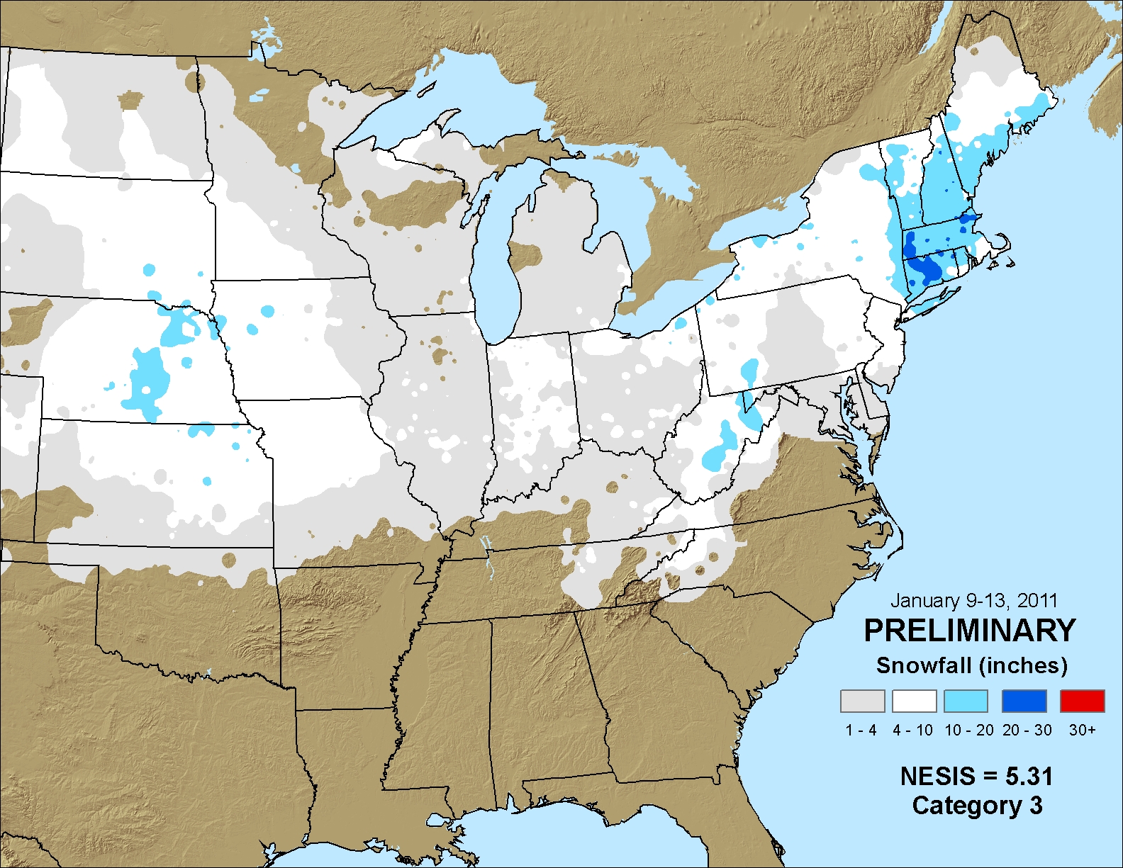
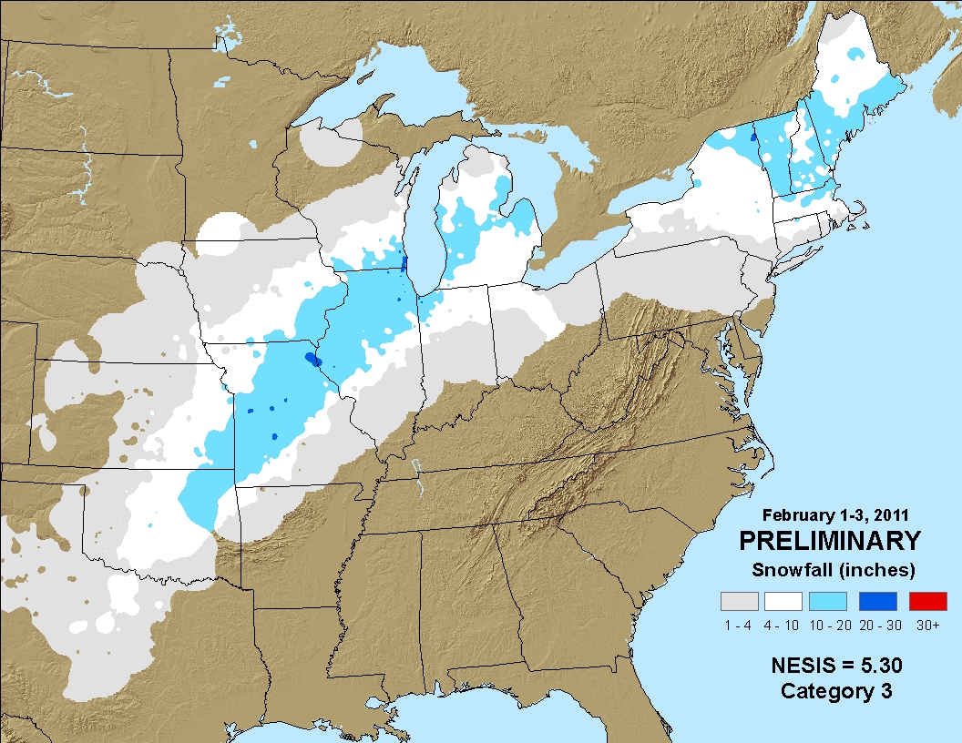
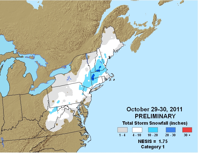
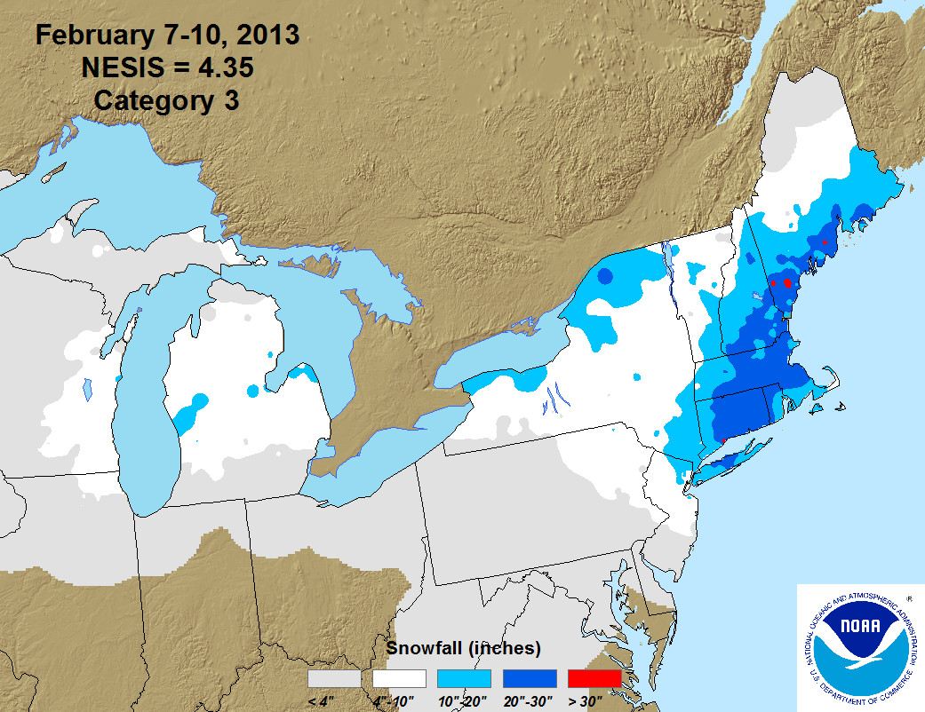
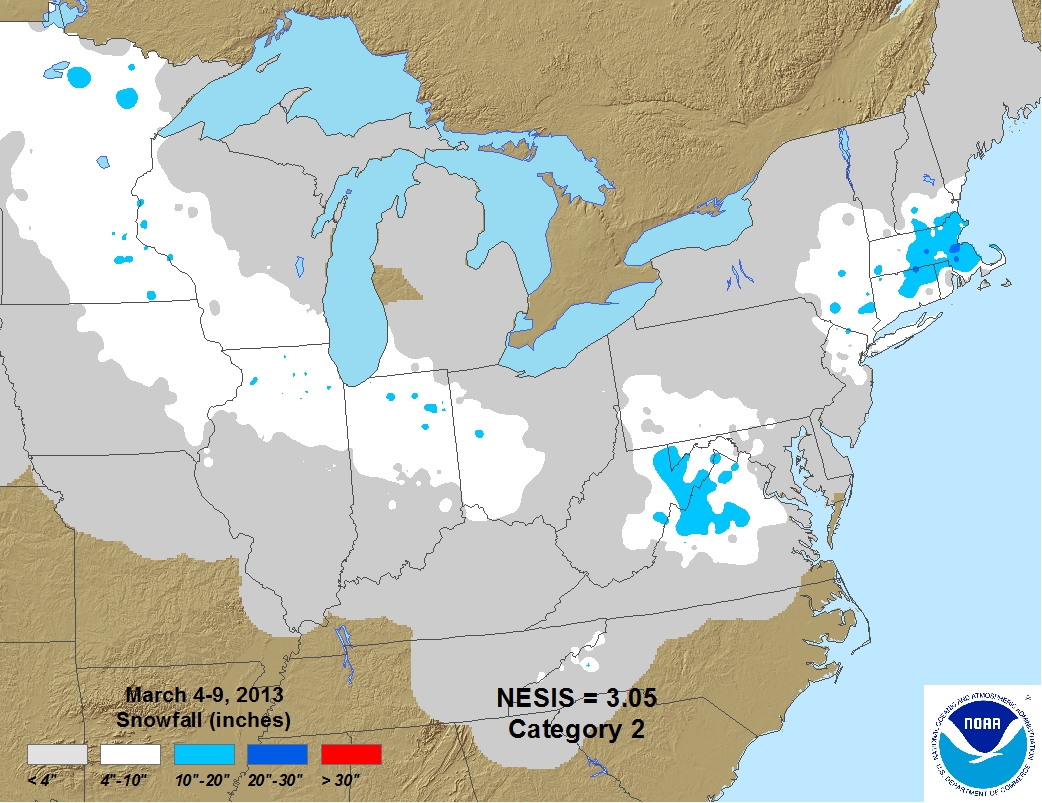
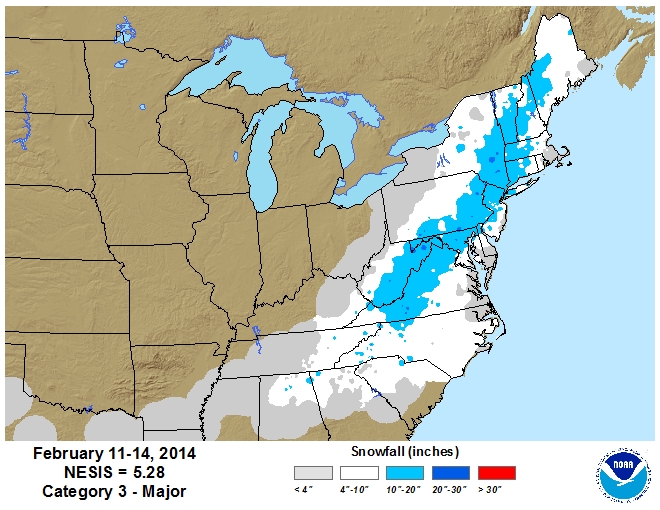
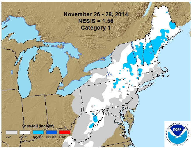
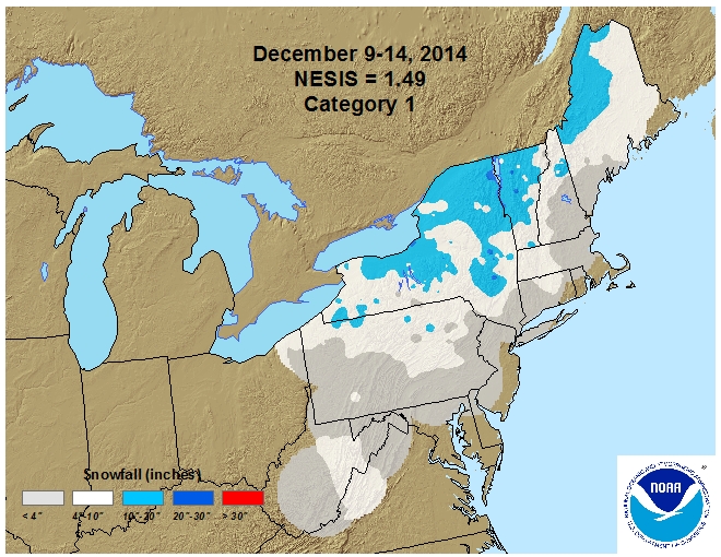
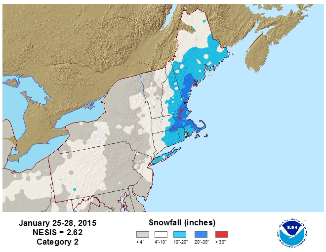
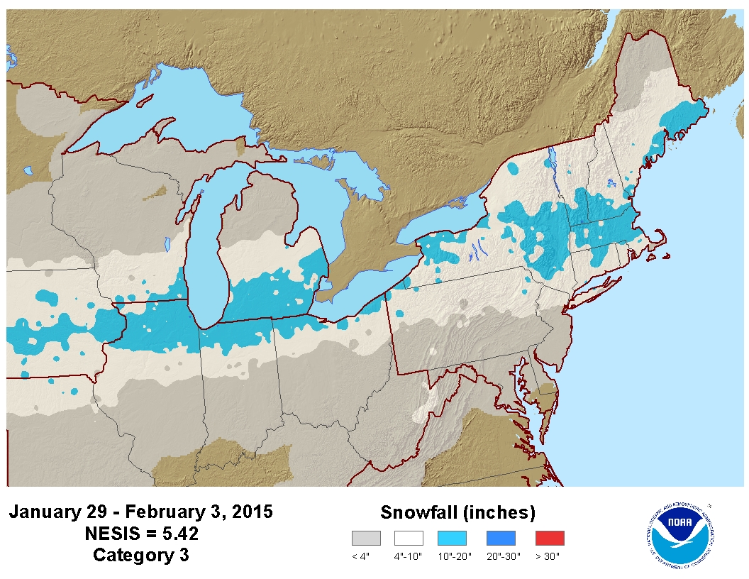
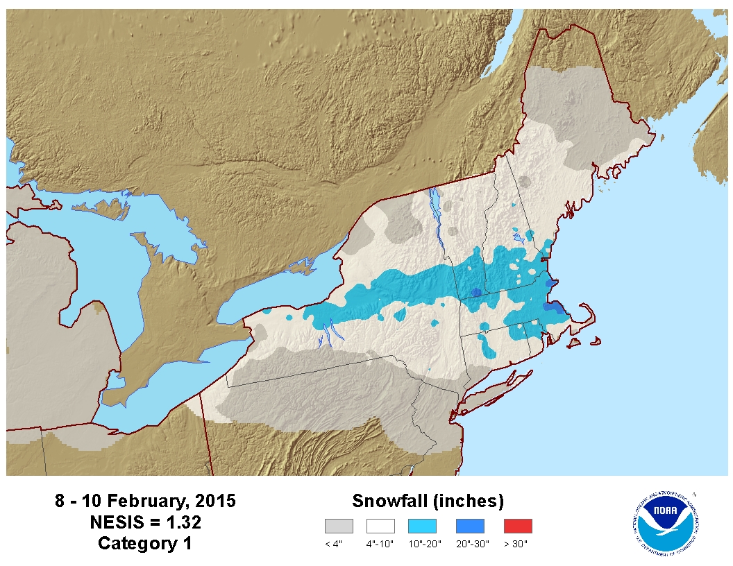
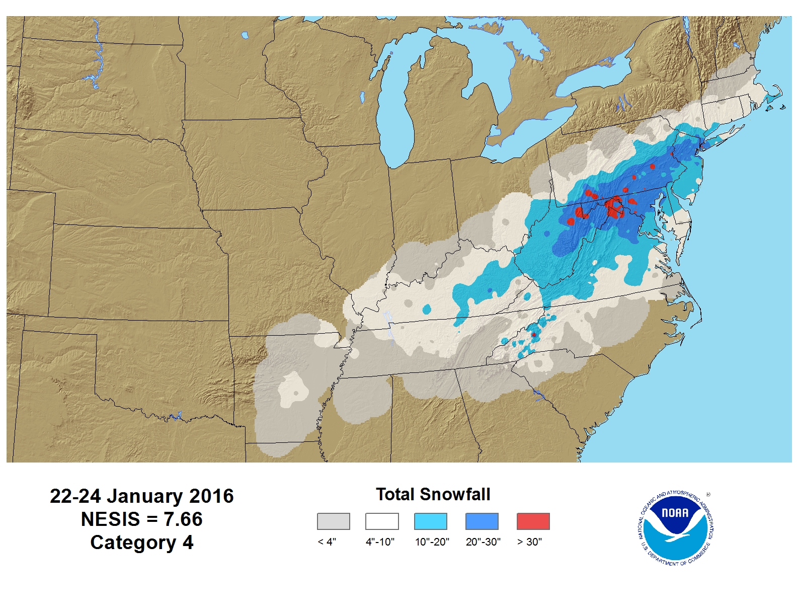
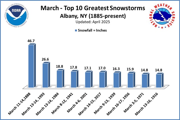
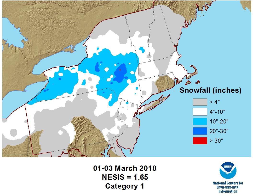