Check out our variations of a printable Europe map political or a Europe Map with countries! You can download any political map of Europe for free as a PDF file. Print out as many copies as you need to teach or learn about the countries of the European continent! Of course, you can also use our maps for other personal or professional purposes.
We also offer other free continent maps and of course a blank map of Europe. So get your free maps now and also take a look at our fun and interactive Europe map worksheets!
Contents
Europe Political Map
The continent of Europe is not to be confused with the European Union. While the geographical region of Europe includes more than 40 countries, the EU only consists of 27 member states. The European Union is an economic and political union while Europe is a continent.
Our first political map of Europe includes only those countries that entirely belong to the continent. However, parts of Russia (until the Ural mountains) and Turkey (the region of East Thrace and a part of Istanbul) geographically belong to Europe as well.

The map does not only show the countries of Europe, but also the European capitals as well as some of the major cities.
Map of Europe with Countries
Here is an alternative map of Europe printable showing today’s political divisions of the European continent. However, this map does not include any capitals or other cities, only the country names.
We also offer labeled and blank maps of all the other continents.
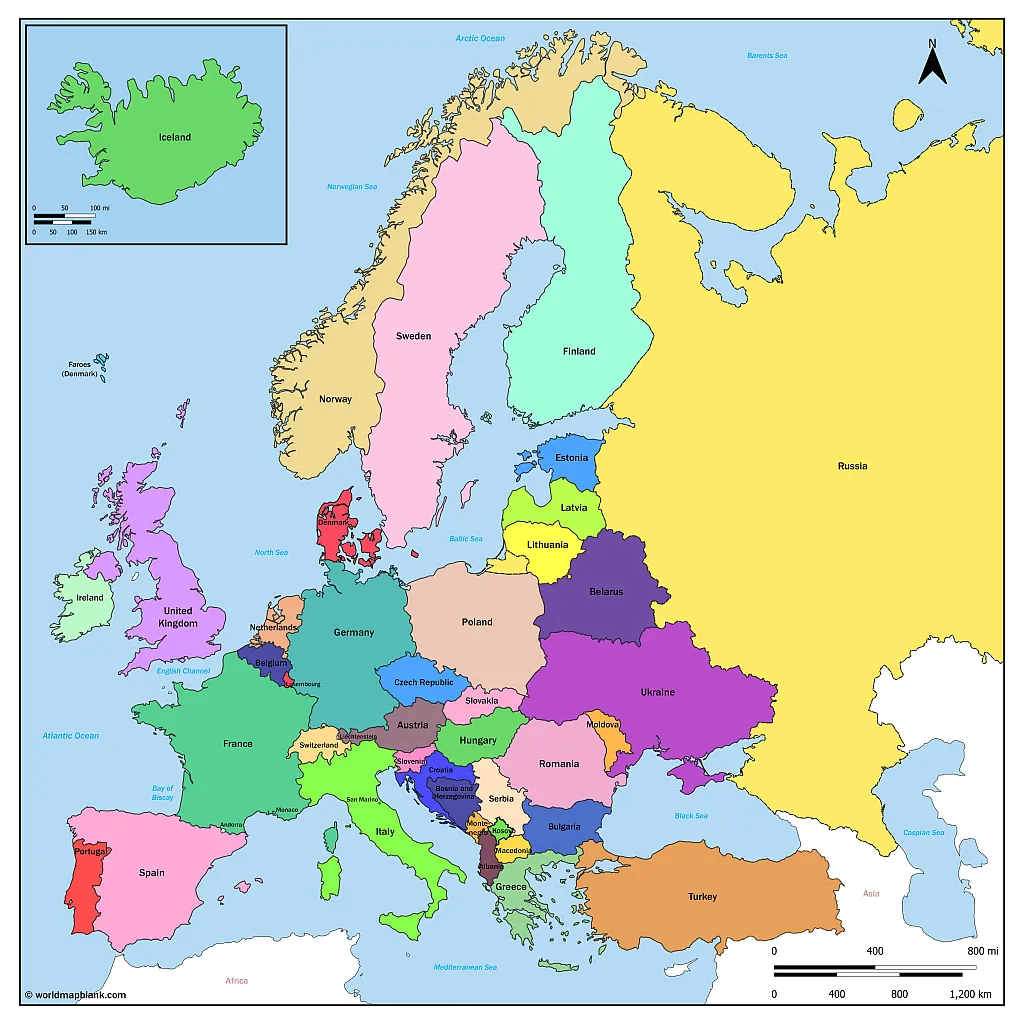
The map also shows the names of oceans and seas in Europe such as the Black Sea, the Mediterranean Sea or the Atlantic Ocean. Additionally, you might want to take a look at our physical map of Europe page.
Cold War Map of Europe Political
Until the fall of the Berlin Wall and the collapse of the Soviet Union, the map of political Europe looked quite different from today. As you can see in the map below, Germany was still divided into two separate states. At the same time, Yugoslavia, Czechoslovakia as well as the USSR still existed as cohesive countries. Today, there are all split up into several independent states.
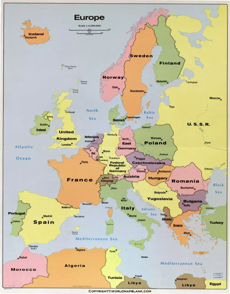
During the times of the Cold war Europe was divided into western Europe and eastern Europe approximately alongside the inner German border. Today, the United Nations suggest the following subdivision:
Northern Europe: UK, Ireland, Iceland, Norway, Sweden, Finland, Denmark, Estonia, Latvia, Lithuania
Southern Europe: Portugal, Spain, Italy, San Marino, Slovenia, Croatia, Bosnia and Herzegovina, Serbia, Kosovo, Albania, Montenegro, North Macedonia, Greece and the European part of Turkey
Eastern Europe: Poland, Czechia, Slovakia, Hungary, Romania, Belarus, Ukraine, Bulgaria, Moldova and the European part of Russia
Western Europe: France, the Netherlands, Belgium, Luxembourg, Germany, Austria, Switzerland and Liechtenstein
One could also argue that countries like Germany, Poland, Austria, Switzerland and others form a separate area of central Europe.
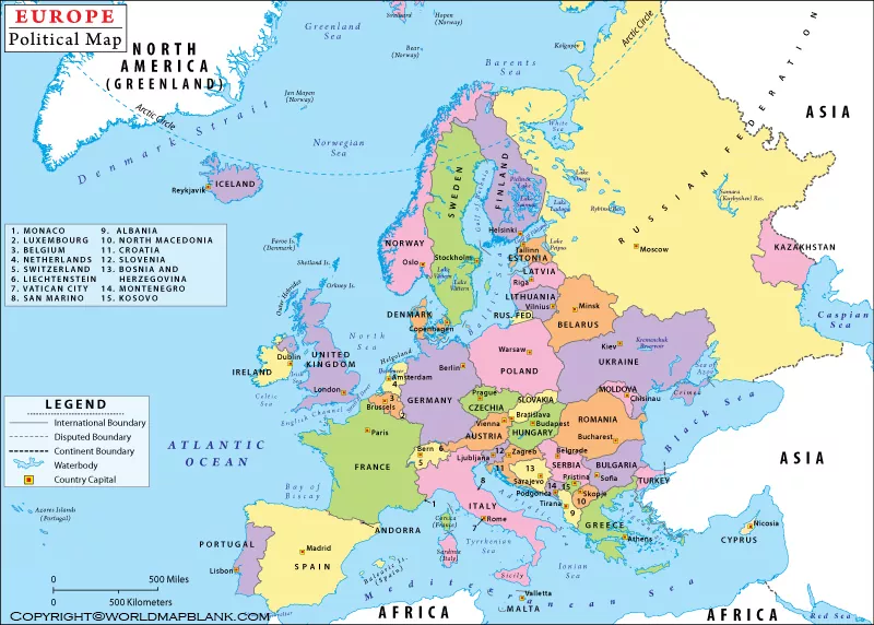
Political Map of Europe with Capitals
The next version below is a Europe map with countries and capitals. Just like the similar map further above, it includes Russia and Turkey into the continent, even if only parts of these countries are in Europe.

Apart from the printable Europe maps on this page, we also provide different variations of a labeled map of Europe. Also, you might want to enhance your teaching or learning experience with a blank map of Europe.
Printable Europe Political Map
The following map shows the European Union with its member states according to the year they became part of the union. In 2022, also the Ukraine was granted EU candidate status as a reaction to the Russian military attack on the country.
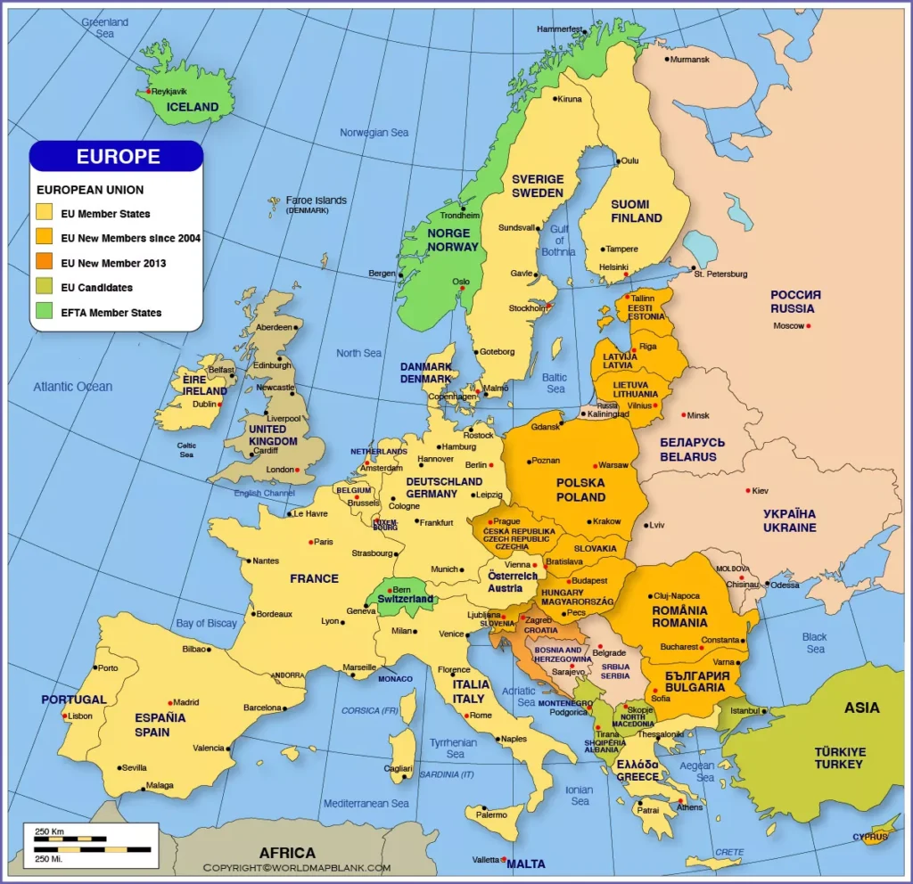
At the time of writing, the European Union consists of 27 member states. Its history can be traced back to 1957, when Belgium, France, Italy, Luxembourg, the Netherlands and the Federal Republic of Germany founded the European Economic Community. The goal was to promote the European integration by a common economic policy.
Europe Political Map Labeled
The European continent stretches from the Atlantic Ocean via the British Isles in the west and north-west to the North Sea and the Baltic Sea in the north and then all the way down to the Black Sea and the Caucasus Mountains in the east – not to forget the Mediterranean Sea in the south.
Among the largest European cities are Istanbul, London, Moscow, Saint Petersburg, Madrid, Berlin, Kyiv, Paris, Rome and Bucharest. Dowload below another Europe map PDF.
Here is a list of all the European countries and capital cities:
- Andorra – Andorra la vella
- Austria – Vienna
- Belarus – Minsk
- Belgium – Brussels
- Bosnia and Herzegovina – Sarajevo
- Bulgaria – Sofia
- Croatia – Zagreb
- Czechia – Prague
- Denmark – Copenhagen
- England – London
- Estonia – Tallinn
- Finland – Helsinki
- France – Paris
- Germany – Berlin
- Greece – Athens
- Hungary – Budapest
- Iceland – Reykjavík
- Ireland – Dublin
- Italy – Rome
- Kosovo – Pristina
- Latvia – Riga
- Liechtenstein – Vaduz
- Lithuania – Vilnius
- Luxembourg – Luxembourg
- Moldova – Chișinău
- Montenegro – Podgorica
- Netherlands – Amsterdam
- North Macedonia – Skopje
- Northern Ireland – Belfast
- Norway – Oslo
- Poland – Warsaw
- Portugal – Lisbon
- Romania – Bucharest
- Russia – Moscow
- San Marino – San Marino
- Scotland – Edinburgh
- Serbia – Belgrade
- Slovakia – Bratislava
- Slovenia – Ljubljana
- Spain – Madrid
- Sweden – Stockholm
- Switzerland – Bern
- Turkey – Ankara
- Ukraine – Kyiv
- Wales – Cardiff
More Free Maps to Download and Print
Have you found the political Europe map you were looking for? If not, maybe you will find a convenient map of Europe or any other map you might need via the link selection below. You can also use our search bar at the top of the page to find more maps of the world, its continents and many countries.
We offer physical, blank and political maps but also river and mountain maps of different regions of the world. You can download them all as PDF files and print them out as often as you like.
Other Maps of Europe
European Country Maps
Map of Germany with States and Cities
Map of Sweden with States and Cities
Other Country Maps
US State Maps
Continent Maps
Labeled Map of Africa with Countries