Wilson County, North Carolina
Wilson County | |
|---|---|
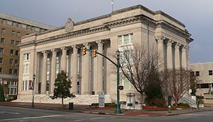
 Wilson County Courthouse | |
 Location within the U.S. state of North Carolina | |
 North Carolina's location within the U.S. | |
| Coordinates: 35°42′01″N 77°55′18″W / 35.700357°N 77.921598°W | |
| Country | |
| State | |
| Founded | 1855 |
| Named for | Col. Louis D. Wilson |
| Seat | Wilson |
| Largest community | Wilson |
| Area | |
| • Total | 373.10 sq mi (966.3 km2) |
| • Land | 367.57 sq mi (952.0 km2) |
| • Water | 5.53 sq mi (14.3 km2) 1.48% |
| Population (2020) | |
| • Total | 78,784 |
| • Density | 214.34/sq mi (82.76/km2) |
| Time zone | UTC−5 (Eastern) |
| • Summer (DST) | UTC−4 (EDT) |
| ZIP Codes | 27542, 27557, 27803, 27807, 27813, 27822, 27829, 27830, 27851, 27852, 27873, 27878, 27880, 27883, 27888, 27893, 27895, 27896 |
| Area code | 252 |
| Congressional district | 1st |
| Website | www |
Wilson County is a county located in the U.S. state of North Carolina. As of the 2020 Census, the population was 78,784.[1] The county seat is Wilson.[2]
References[change | change source]
- ↑ "QuickFacts: Wilson County, North Carolina". United States Census Bureau. Retrieved January 18, 2024.
- ↑ "Find a County". National Association of Counties. Retrieved 2011-06-07.


