Review Highlights

“But we saw two others coming our way, we waited for them, and the 4 of us managed to get to Trail Crest by 7 am.” in 21 reviews

“There are maybe about 8 river/water crossings, but the second one is the hardest (maybe about 1/3 of a mile from Whitney Portal).” in 23 reviews

“8 mile hike to Lone Pine Lake to take pictures and look at the trail I would be hiking at night.” in 11 reviews
Location & Hours

You Might Also Consider

in Kids Activities, Party & Event Planning, Indoor Playcentre
Amenities and More
Ask the Community
Q:
Anyone hiking up on May 17th? Few people that attempted the hike suggested to start at 1am and bring crampons and ice axes. A lot of packed/slushy snow just before lone pine lake. Slow and easy!!!
A:
We have a permit for the 28th. Not sure if we'll be able to summit, may change plans.
Candace L.7 years ago
Recommended Reviews
Overall rating
110 reviews
5 stars
4 stars
3 stars
2 stars
1 star
- Mar 12, 2023
Was camping in Death Valley for a few days and we decided to go check out Mt Whitney and the Whitney portals.
It was cold about 35 degrees, wind blowing, snow covering the ground and a little melt on the road. Luckily it was not raining when we were there.
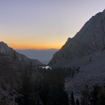
Pretty incredible views, they speak for themselves.
We were there about an hour but the wind was really causing havoc and the temperature was dropping fast so we decided to head out and will go back another time.
With the nearby Alabama Hills to also explore, this is a photographer's dream.


 Helpful 9
 Thanks 1
 Love this 10
 Oh no 0
  MyReviews A.San Diego, CA081Nov 16, 2023
Take a hike!! Pretty amazing experience. Not an easy hike to the top but totally worth it. Second highest peak in the US. Do it!
Helpful 0Thanks 0Love this 0Oh no 0 3566181144Apr 10, 2022
Few things in my life have been as difficult or challenging as this hike.
We applied for the single day hike lottery and won. I believe our date was sometime in August of 2020.
After a nice early turn in at the lone pine Campground. We began our journey at about 1am. Under the cover of darkness we set out by partial moonlight and headlamp.
We packed fairly light. As this was just a day trip. We brought multiple layers of clothing. Beanie caps. Hats for the sun, sunscreen, sunglasses, an e-tool (folding shovel), wipes, a h2o pump/filter, 4 hydration systems, 4 field stripped MRES, and a bunch of snacks like jerkey, trail mix, cliff bars etc.
We didn't really do anything all that special to prepare for this hike other than a few measly hikes. And our normal work out routines.
We did hike crystal lake near Mammoth two days prior. And we hiked methuselahs trail at the ancient bristlecone pine forest in Bishop,CA the day prior. I feel both of these hikes got our lungs acclimated and our legs stretched and ready to go.
I do wish we would have done more to prepare for this. As it had taken us a whopping 22 hours to complete the 22 miles of this journey.
This was both my wife and I's first ever 14er.
A few things I'd change for the next one. I would pack lighter! And train up for it.
In all this was one of the best experiences of my life. Hands down the hardest hike I've ever done. I would highly recommend this adventure to anyone feeling brave enough!Helpful 2Thanks 0Love this 1Oh no 0 678258533Sep 27, 2022
i had the most difficult yet rewarding hike of my life here. there are many things to consider with this hike, so i suggest you spend a good amount of time researching what is necessary before embarking on this trip. i'll break it down simply-
1st, you need to get a permit. you go to recreation.gov and apply, and if it's your first time i hiiiiiiighly suggest doing a backpacking permit and not the 1 day permit. it will make a world of difference. if you get the 1 day anyway start no later than 2am tbh. better earlier cuz the sun hits harder at 10,000 ft.
2nd, you'll need to train. i found that running/swimming/biking many times a week was not enough. altitude sickness doesn't really care, so you'll have to hike a few peaks to train. if you are in so cal like me, i suggest doing the 6 packs of peaks challenge, which is local mtns in the angeles crest, idyllwild, etc. i got really bad altitude sickness due to the elevation of 13,000 ft. it was one of the most uncomfortable feelings i've ever felt. so, be sure to train, on a mountain peak, multiple times and get your way up to at least 12,000 ft, i'd say.
thirdly, you'll need to pack layers thin and warm due to the variance of alpine temperatures. double socks, one thin one thick, to prevent blisters. sunscreen/sunhoodies. water filter, and use the farout app to find a map with water markings. i do like using all trails too, to anticipate elevation gain and distance. kinda worth it to get the pro i think. trekking poles allow you to use your arms to be more agile, highly recommend. watch out for the marmots, they are not afraid of you and will try to eat your snacks/go through your backpack. at the beginning of the trailhead, you'll pick up a "wag bag" which is a poo poo bag basically, they do it to protect the nature or whatever. completely uncomfortable experience. try not to eat too much and probably best to take pills such as imodium (makes you not poop much) or diamox (makes you pee more and your blood vessels expand so you can feel better at high altitudes. do not go all the way up if you get alpine fever or whatever, it's not worth it. anyway, i hope my guide helped. it's beautiful out here and i've never been more amazed by a landscape before. 10/10 recommend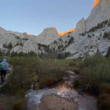 Helpful 2Thanks 0Love this 2Oh no 0
 2704692065Sep 18, 2022
A tale of things not to do.
On February 1, eight of us applied for overnight permits of 6 people with Sat Sep 3 (Labor day weekend) as a preferred day and Sat Sep 17 as a back up. As luck would have it, on Mar 24 I was the only one who landed an overnight permit on Sep 17. As more luck would have it, we also landed half dome permits for the weekend before on Sep 9. To top it off, the weather at the summit for Sep 17 looked super gnarly, from snow to rain to 35mph (the weather on Sep 3 was perfect). Apparently this year's weather conditions changed hour by hour.
Three of us not cowed by half dome the week before teetered on cancelling all week leading up to the Friday when we would head up. We decided we had two options: 1) Hike to mile 6 at Trail Camp, drop off gear, and summit on day 1, hike back down and sleep at Trial Camp. If we failed on day 1, we could try again the next day. 2) Hike to mile 6 at Trail Camp, camp for the night to acclimate, then summit on day 2, hike back down and drive home. We would either suffer on the front end or the back end. The team opted for 1.
What could have been a 3.5-4h commute turned into a 6.5h commute due to traffic and a shopping excursion (one disorganized member of our party disclosed he had forgotten to bring hiking pants). We arrived at Whitney Portal at 730pm, set up our tents, packed for the next morning, agreed to wake up at 330am, and slept by 930pm. At 430am our disorganized friend finished repacking his pack. We drove the 2 miles from Whitney Portal campground to the trailhead overflow lot, deposited our smellies into the bear box, and waited again for our disorganized friend to continue to repack his pack. I walked us right past the trailhead in the dark. At 615am we finally started our hike. Almost immediately, we started overheating and stripped down to our base layers to hike. We continued to sweat through that. About 30 minutes in, it started to dawn on the two newbie backpackers that they may have overpacked, weighing in at at least 40lb+ each. We crawled up the mountain to the tune of an hour an mile.
At about 3 miles in, our disorganized friend took a pee break and waved us on. We encountered a hiker who stayed at Trail Camp and said that in the 4-5 times he's summited, he's never been so cold as last night. With that warning in mind, we stopped at the beautiful outpost camp (3.8 miles), made breakfast and put on layers while we waited an hour for our friend who was taking a "pee" break. Our friend eventually showed up, we set up our tent, and continued to try for a summit at 10am.
I pushed the crew to stop stopping for breaks but we still clocked in at about an hour a mile. We finally reached Trail Camp (12000ft) at around 130pm, took too long of a break, and started up the 99 switchbacks. At about an hour in, one of our party started to feel dizzy. He had tried to obtain a prescription for Diamox but his physician talked him out of it by claiming the side effects were as bad as altitude sickness. The other still wanted to carry on. We decided I would try to summit that day with one, and I would summit again the next day with the other. Not long after, all the while harassing my buddy to pick up the pace, I talked to some folks coming down the switchbacks. They were nervous about our trying to summit this late in the day, as we had maybe 30 minutes left of the switchbacks, then 2.5 hours of trail crest, would boulder through trail crest when the wind was picking up, and have to boulder down in the dark. I called it at that point, around 13000ft and about 7 miles in, as I should have earlier but in a fit of stupid righteousness magnanimous overture I let my friends' eagerness to summit override my frustration at our snail's pace. We arrived back at Outpost at 7pm. My friend's altitude sickness had not only not subsided, it had gotten worse and he didn't want to try to summit the next day. The other friend also admitted to altitude sickness manifesting as extreme fatigue, having not taking his Diamox because he was concerned about side effects. He also did not want to try to summit the next day. I didn't actually care about summiting as I only hike in order to camp, but as the group leader this situation was frustrating. I should have hustled the group along so we could start earlier, but the fact of the matter is you are only as early as your most disorganized member, and as fast as your slowest member.
The silver lining was that we were able to get home at a decent hour. Whitney is one of the prettiest sceneries around. We expected hail and ice but got great weather. Even if we had tried to summit on Sunday, the winds were blowing up to 35mph at the summit, leading to single digit temperatures. Many, many lessons were learned.Helpful 2Thanks 0Love this 2Oh no 0 4675401293Jul 5, 2020
Summiting Mt. Whitney was one of the hardest backpacking/hiking trips I've done. From getting the permits, to my ENTIRE group of six completing the summit, the stars all aligned for us this trip. Read this hiking guide to help with planning (it is much more detailed that I ever could be):
https://hikingguy.com/hike/hiking-trails/hikes-around-mt-whitney/
This is the breakdown of our 48 hour trip:
Day 1- Meet at Whitney Portal and backpack to Trail Camp (~6.3 miles)
Day 2 - Summit Mt. Whitney (~ 4.7 miles) return to camp to eat and pack up (~4.7 miles) backpack out to Whitney Portal (~6.3 miles)
TIPS:
*the mosquitos here are REAL big and hungry - drench yourself in bug spray
*use a water filter instead of carrying all your water - there are plenty of good water sources
*eat and drink frequently
*wear sunscreen
Overall, a really cool trip but probably won't re-do due to the altitude and post trip pains. Still... highly recommend!Helpful 5Thanks 0Love this 3Oh no 0- Mar 16, 2022
Hate the lottery system for permits, and I don't particularly enjoy summer hiking anyway. Winter climbs here are way less crowded and so beautiful just be sure you're safe and have the correct equipment and know-how
Helpful 1Thanks 0Love this 0Oh no 0 - Oct 24, 2018
This has been on my bucket list and would never thought I'd be able to hike it but the day has come.
With the popularity of the place, permits always gets sold out but luckily a friend got a day permit on this late season. Anyways here's how it went.
Saturday morning arrival of 4am into Lone Pine to TRY to get acclimated to the altitude. Got to camp and took a nap. Woke up at 1pm and went for a warmup hike (6.3 miles). Got back, ate dinner and went to bed at 8pm.
Sunday morning 2am wake up. Pack away the tents and other stuff.
3am rolls around and we are off on the trail. It's dark, weather is 34 degrees and roughly 11 miles til we reach the summit. The trail is situated in between two sheer mountains and zig zags within it. You're already starting at 8600+ ft of elevation so it's already up there in altitude. After about mile six you're above the tree line and into the Rocky Mountain terrain. Stopped to refill on some fresh ice cold mountain water and started up the famous 99 Switchbacks. These was hell and torture. All 3 miles worth and not only that it was icy and snowy at some parts.
After 2-3 hours we made it to the Trail crest and was greeted with such a spectacular view and now know the summit is so near with only 3 miles remaining. However it's the hardest 3 miles when you can see the end is near but yet so far. With deadly steep edges on one side and sheer walls on the other, topped with icy narrow trails, one slip and it's over.
Another 2 hours and we are at summit, greeted with blue skies and some clouds in the distance. The Views here is just gorgeous and infinite with 360 degrees of the surrounding valley.
After taking pics with the signs and officially signing the log book, we make our way down towards camp. However as we are leaving, I can see a huge rain cloud coming our way and little do you know we crossed path at the crest and was greeted with a hour long snow shower that blanketed the upper half of the hike. Now we have to slow down and trek carefully back to trail camp at mile 6 where we refilled on water again before making the last stretch down. Now you would think it's all downhill from the top and would be a piece of cake?
NOPE!!!! The last six miles was the worse and brutal part of a hike I've ever experienced. From the lack of real food to altitude to the cold weather and pain from the feet to the whole body, every step was excruciating. Well 4 hours later we are back at camp. What a experience
Mt. Whitney has to offer.
Trail is well laid out and clear with beautiful wooded area. Many lakes and streams to enjoy and refill water from. Amazing views all throughout the hike. But don't let this fool you, as this is one tough hike and we sure as hell underestimated the mountain. Not that I would do it again but if I did, I'd definitely be training for it.
This is a once in a lifetime experience for me and a check off my bucket list.
If you're a outdoor person and love nature and hiking you just give it a shot.
Sorry for the long review but I had to share.Helpful 7Thanks 0Love this 6Oh no 0  Ju L.Washington, DC7770Jul 30, 2022
Pros: Mount Whitney Portal Road has spectacular views for 11 miles. Turn off onto the well maintained dirt Movie Road is highly recommended. Waterfall. Fishing pond.
Cons: N/AHelpful 0Thanks 0Love this 0Oh no 0- Apr 19, 2018
On September 5th, 2017; my climbing partner and I summitted Mt Whitney by the East Face route!
This route goes up from Iceberg Lake and skips the long, switchbacking hiker's trail to the top. We descended the "Mountaineer's Route" which is pretty much a scramble/snow climb.
The upper mountain is an alien landscape devoid of most vegetation. There's a "cabin" on the top where you can huddle up close with other climbers/hikers.
The approach up to Iceberg Lake was...not very straight-forward. Calling it a "trail" is probably giving it a bit too much credit. Make sure you read lots of beta on the approach (summitpost is a good place to start) as well as the climb.
The climbing? Spectacular. Bomber, golden granite. Lots of great holds, lots of great cracks for protection, and lots of exposure. It's pretty much everything you want alpine rock climbing to be!
When we reached the summit we were treated to...a small snow storm! By the time we were back down at camp it was sunny again. This mountain is known for afternoon storms, so start EARLY.
I'd love to come back and climb the East Buttress or even...Fishhook Arête on nearby Mt Russell!Helpful 4Thanks 0Love this 6Oh no 0